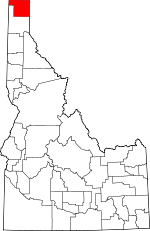
Boundary County, Idaho Basics:


Boundary County Idaho - Government Site

Population: 10,832
Area: 1269 square miles
County seat: Bonners Ferry
Area code(s) in use: 208
Time zone: PST
High school graduate or higher: 83.8%
Bachelor's degree or higher: 14.2%
Median household income: $36,300
Persons in poverty: 16.1%
Home ownership rate: 75.6%
Mean travel time to work: 19.6 minutes


Adjacent counties:
Bonner  Lincoln (MT)  Pend Oreille (WA)  
Find in Idaho

Map of the Boundary County area


Our detail map of Boundary County shows the Boundary County, Idaho boundary lines and other interesting items.

Places in Boundary County, Idaho

  Airports     show all on map

Boundary County Airport, Eckhart International Airport

  Benches     show all on map

North Bench

  Bridges     show all on map

Twin Bridges

  Buildings     show all on map

Bonners Ferry Fire Department Station 1, Bonners Ferry Fire Department Station 2, Bonners Ferry Police Department, Boundary County Sheriff's Office, Curley Creek Volunteer Fire Department, Curley Creek Volunteer Fire Department Station 2, Hall Mountain Volunteer Fire Department Station 1, Hall Mountain Volunteer Fire Department Station 2, Hall Mountain Volunteer Fire Department Station 3, Kootenai Valley Forest Protection District, Moyie Springs Fire Department, North Bench Fire Department, North Bench Fire Department Station 2, Paradise Valley Fire Department, South Boundary Fire Protection District Station 1, South Boundary Fire Protection District Station 2

  Cemeteries     show all on map

Boulder Creek Cemetery, Copeland Cemetery, Grandview Cemetery, Independent Order of Odd Fellows Cemetery, Moravia Cemetery, Paradise Valley Cemetery

  Churches     show all on map

Indian Mission

  Dams     show all on map

Ansley Dam, Erickson Dam, McArthur Dam, Moyie Dam, Nixon Number One Dam, Nixon Number Two Dam

  Falls     show all on map

Caribou Falls, Copper Falls, Moyie Falls, Smith Falls, Snow Creek Falls, Upper Priest Falls

  Flats     show all on map

Deer Park, Highland Flats, Hughes Meadows, Kootenai Orchard, Round Prairie

  Gaps     show all on map

Cabinet Pass, Canuck Pass, Caribou Pass, Cooks Pass, Katka Pass, Kelly Pass, Long Canyon Pass, Pyramid Pass, Ruby Pass, Twentymile Pass

  Hospitals     show all on map

Boundary Community Hospital

  Islands     show all on map

O'Callaghans Island

  Lakes     show all on map

Ball Lakes, Bass Lake, Beaver Lake, Beehive lake, Beehive Lakes, Big Fisher Lake, Bloom Lake, Blue Lake, Bond Lake, Bonner Lake, Bottleneck Lake, Bradley Lake, Brooks Lake, Brush Lake, Bussard Lake, Canyon Lake, Caribou Lakes, Continental Lake, Cooks Lake, Copper Lake, Corner Lake, Cutoff Lake, Dawson Lake, Deer Lake Swamp, Divide Lake, Fault Lake, Geyselman Lake, Harrison Lake, Herman Lake, Hidden Lake, Hunt Lake, Jerome Slu, Joe Lake, Kent Lake, Kerr Lake, Long Mountain Lake, Lookout Lake, Marsh Lake, McCormick Lake, Mollies Lake, Myrtle Lake, Parker Lake, Perkins Lake, Pyramid Lake, Queen Lake, Robinson Lake, Roman Nose Lakes, Saddle Lake, Search Lake, Sinclair Lake, Smith Lake, Snow Lake, Solomon Lake, Spruce Lake, Stampede Lake, Standard Lakes, Templeman Lake, Trap Lake, Trout Lake, Two Mouth Lakes, Upper Standard Lake, West Fork Lake

  Locales     show all on map

Bass Lake Access, Black Mountain Lookout, Bonner Lake Access Area, Bonners Ferry Ranger Station, Bonners Ferry Substation, Borthill Ferry, Brush Lake Campground, Camp Eight, Camp Five, Camp Nine, Copeland Ferry, Copper Creek Campground, Dawson Lake Access Area, Deep Creek, Deep Creek Access Area, Deep Creek Campground, Deer Park Community Hall, DeVoignes Spur, Dirt Oven Campground, Dugals Loop, Edwards Spur, Harpers Spur, Highland Flats Community Hall, Houcks Spur, Hughes Meadows Fire Station, Hughes Ridge Viewpoint, KV Farm Spur, MacDonalds Number 1, McArthur Lake Access, McArthur Wildlife Management Area, Meadow Creek Campground, Movie River Sportsmans Access, Moyie River Access Area, Osburn Vista, Red Top Lookout, Robinson Lake Boat Launch, Robinson Lake Campground, Russell Mountain Lookout, Seelovers Spur, Selkirk Crest Management Area, Sheridan School, Shorty Peak Lookout, Smith Creek Guard Station, Smith Lake Campground, United States Forest Service Camp 216, Watson Spur, West Fork Cabin

  Mines     show all on map

American Girl Mine, Bethlehem Mine, Boulder Mine, Buckhorn Mine, Continental Mine, Golen Scepter Mine, Homestake Mine, Idamont Mine, McLean Mine, Miller Brothers Mine, Montgomery Mine, Parker Mine, Queen Mine, Regal Mine, Rideout Mine, Tilley Mine, Tungsten Hill Mine

  Parks     show all on map

Deep Creek Picnic Area, Hunt Girl Creek Research Natural Area, Kootenai National Wildlife Refuge, Myrtle Creek Game Preserve, Priest Lake State Forest

  Populated Places     show all on map

Addie, Allens Spur, Bonners Ferry, Boulder City (historical), Burns, Copeland, Crossport, Deep Creek, Eastport, Eileen, Good Grief, Katka, Leonia, Mc Arthur, Meadow Creek, Moravia, Moyie Springs, Naples, Porthill, Ritz, Schnoors, Shiloh, Sinclair, Threemile Corner

  Post Offices     show all on map

Klockmann Post Office (historical)

  Ranges     show all on map

Selkirk Mountains, Seven Sisters

  Reservoirs     show all on map

Lower Standard Lake, McArthur Lake, Smith Lake

  Ridges     show all on map

Apache Ridge, Buckhorn Ridge, Bugle Ridge, Camels Prairie, Caribou Ridge, Cascade Ridge, Copper Ridge, Dawson Ridge, Deer Ridge, Farnham Ridge, Horton Ridge, Hughes Ridge, Jeru Ridge, Katka Ridge, Lions Head Ridge, McCormick Ridge, McGinty Ridge, Ruby Ridge, Ruby Ridge, Russell Ridge, Slate Ridge, Snow Ridge

  Schools     show all on map

Bonners Ferry High School, Boundary County Junior High School, Evergreen Elementary School, Mount Hall Elementary School, Naples Elementary-Junior High School, North Side School, Praise Church Christian Academy, Rocky Mountain Academy, Valley View Elementary-Junior High School

  Springs     show all on map

Leslie Springs

  Streams     show all on map

Abandon Creek, Adverse Creek, Bad River, Ball Creek, Bane Creek, Bear Creek, Beaver Creek, Beehive Creek, Bench Creek, Big Canyon Creek, Black Creek, Blanc Creek, Blue Joe Creek, Bog Creek, Boulder Creek, Boundary Creek, Brass Creek, Brown Creek, Brush Creek, Brush Creek, Burton Creek, Bussard Creek, Cabin Creek, Cabin Creek, Caboose Creek, Camp Creek, Caribou Creek, Cascade Creek, Cedar Creek, Cedar Creek, Chimney Creek, Clark Creek, Clifty Creek, Cone Creek, Continental Creek, Contrary Creek, Cooks Creek, Copper Creek, Corner Creek, Cottonwood Creek, Cow Creek, Cow Creek, Curley Creek, Curve Creek, Cutoff Creek, Davis Creek, Deep Creek, Deer Creek, Dobson Creek, Dodge Creek, Dodge Creek, Dutch Creek, East Fork Boulder Creek, East Fork Meadow Creek, East Fork Mission Creek, English Creek, Fall Creek, Fan Creek, Farnham Creek, Faro Creek, Feist Creek, Fern Creek, Finn Creek, Fisher Creek, Fleming Creek, Found Girl Creek, French Creek, Frost Creek, Fry Creek, Gable Creek, Gillon Creek, Gin Creek, Gold Creek, Grass Creek, Gunsight Creek, Hall Creek, Ham Creek, Harvey Creek, Hellroaring Creek, Highland Creek, Homestead Creek, Hunt Girl Creek, Irish Creek, Italian Creek, Jackson Creek, Jeru Creek, Jim Creek, John Crown Creek, Katka Creek, Keno Creek, Kent Creek, Kingsley Creek, Kreist Creek, Lime Creek, Lime Creek, Line Creek, Little Hellroaring Creek, Long Canyon Creek, Lost Creek, Lucas Creek, Mack Creek, Malcom Creek, Marsh Creek, Martin Creek, McCormick Creek, McDougal Creek, McGinty Creek, Meadow Creek, Middle Fork Boulder Creek, Mill Creek, Miller Creek, Mission Creek, Molar Creek, Moyie River, Myrtle Creek, Olds Creek, Orser Creek, Parker Creek, Peak Creek, Pearson Creek, Pinochle Creek, Placer Creek, Poker Creek, Pouch Creek, Prohibition Creek, Pulp Creek, Rock Creek, Rock Creek, Roman Nose Creek, Round Prairie Creek, Ruby Creek, Rummy Creek, Rutledge Creek, Saddle Creek, Sand Creek, Scotch Creek, Search Creek, Seed Creek, Shorty Creek, Silver Creek, Skin Creek, Slide Creek, Slide Creek, Smith Creek, Snow Creek, Snow Creek, Snyder Creek, Solomon Creek, South Fork Dodge Creek, Spanish Creek, Spread Creek, Spruce Creek, Swede Creek, Swiss Creek, Templeman Creek, Thor Creek, Toot Creek, Torrent Creek, Trail Creek, Treble Creek, Trout Creek, Turk Creek, Twentymile Creek, Wall Creek, Webber Slough, West Branch Deer Creek, West Branch Pack River, West Fork Smith Creek, Wishbone Creek, Yellow Pine Creek, Youngs Creek, Zee Creek, Zion Creek, Zuni Creek

  Summits     show all on map

Abandon Mountain, Bald Eagle Mountain, Bethlehem Mountain, Black Mountain, Blue Joe Mountain, Border Mountain, Bottleneck Peak, Boulder Mountain, Buck Mountain, Buckhorn Mountain, Burton Peak, Bussard Mountain, Canida Peak, Chimney Rock Middle Cairn, Clifty Mountain, Continental Mountain, Cooks Peak, Copper Mountain, Cutoff Peak, Dodge Peak, Eddy Peak, Eneas Peak, Farnham Peak, Fisher Peak, Goat Mountain, Goblin Knob, Grass Mountain, Green Bonnet Mountain, Hall Mountain, Harrison Peak, Harvey Mountain, Hogue Mountain, Hunt Peak, Iron Mountain, Italian Peak, Jay Peak, Jeru Park, Joe Peak, Kaniksu Mountain, Katka Peak, Kent Peak, Klootch Mountain, Kootenai Point, Lake Mountain, Leonia Knob, Line Point, Little Snowy Top, Lone Tree Peak, Long Mountain, Lookout Mountain, Middle Mountain, Mission Hill, Mission Mountain, Mount Roothaan, Myrtle Peak, Parker Peak, Phoebe Tip, Pyramid Peak, Queen Mountain, Red Top, Reno Mountain, Roman Nose, Round Mountain, Ruby Mountain, Russell Mountain, Saddle Mountain, Sand Mountain, Shorty Peak, Silver Dollar Peak, Silver Mountain, Smith Peak, Snow Peak, Snowy Top, Solomon Mountain, Star Mountain, Stein Mountain, Temple Mountain, The Lions Head, The Scout, The Wigwams, Timber Mountain, Trapper Peak, Tungsten Mountain, Twentymile Peak, Twin Peaks, Two Tail Peak, Wall Mountain, West Fork Mountain, White Mountain

  Towers     show all on map

Camels Prairie Lookout Tower, Deer Ridge Lookout, KBFI-AM (Bonners Ferry)

  Trails     show all on map

Beaver Lake Trail, Buck Mountain Trail, Burro Ridge Trail, Copper Creek Trail, Danquist Trail, Dobson Creek Trail, East Fork Boulder Creek Trail, Gable Creek Trail, Grouse Mountain Trail, Hall Mountain Trail, Hellroaring Ridge Trail, Iron Mountain Trail, Katka Peak Trail, Kelly Pass Trail, Leonia Trail, Queen Mountain Trail, Ruby Ridge Trail, Rutledge Creek Trail, Sidehill Trail, Smythe Trail, Timber Mountain Trail, Upper North Fork Grouse Creek Trail, White Mountain Trail

  Valleys     show all on map

Paradise Valley, Purcell Trench,

Boundary County, Idaho Population By Race (2012 estimate)

RacePopulation
WhiteBoundary County White population 10,26910,268  
American IndianBoundary County American Indian population 238238
MixedBoundary County Mixed population 217216
AsianBoundary County Asian population 6564
BlackBoundary County Black population 4343
Hawaiian & Pacific IslanderBoundary County Hawaiian & Pacific Islander population 1110

Additional population tables :
State population table
Idaho population by county