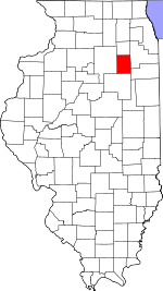
Grundy County, Illinois Basics:
Grundy County Illinois - Government Site
Population: 50,208
Area: 418 square miles
County seat: Morris
Area code(s) in use: 815
Time zone: CST
High school graduate or higher: 91.1%
Bachelor's degree or higher: 19.1%
Median household income: $63,840
Persons in poverty: 8.6%
Home ownership rate: 76.1%
Mean travel time to work: 29.0 minutes
Adjacent counties:
Kankakee Kendall La Salle Livingston Will
Places in Grundy County, Illinois
Curanda Airport,
Dwight Airport,
J B Fillman Airport,
Matteson RLA Airport,
Morris Hospital Heliport,
Morris Municipal Airport-James R. Washburn Field,
Nelson Airport,
Three Rivers Farm Airport Goose Lake Prairie Pine Bluff Bridge Braceville Fire Department,
Coal City Fire Protection District,
Gardner Volunteer Fire Department - Gardner Emergency Medical Services,
Grundy County Courthouse,
Lyondell Chemical Company,
Mazon Community Fire Department,
Minooka Fire Department Station 1,
Minooka Fire Department Station 2,
Morris City Hall,
Morris Fire Protection and Ambulance District Station 1,
Morris Fire Protection and Ambulance District Station 2,
Morris Healthcare Rehabilitation Center,
MVK Ambulance Service,
Norman Town Hall,
South Wilmington Volunteer Fire Department,
Verona - Kinsman Fire Protection District Aux Sable Aqueduct,
Claypool Ditch,
Nettle Creek Aqueduct Anderson Cemetery, Augustine Cemetery,
Aux Sable Cemetery, Barner Cemetery,
Brookside Cemetery,
Catholic North Cemetery, Cholera Cemetery, Claypool Cemetery,
Cotton Cemetery,
Cryder Cemetery,
Dresden Cemetery,
Evergreen Cemetery, Farmingdale Cemetery, Garfield Cemetery,
Goodfarm Cemetery,
Grand Prairie Lutheran Cemetery, Hartford Cemetery, Hoge-Holderman Cemetery,
Holderman and Hoge Cemetery,
Holderman Cemetery, Hollenbeck Cemetery, Italian Cemetery, Lamb Property Cemetery,
Mount Carmel Cemetery, Norman Cemetery, Oak Ridge Cemetery, Oak Ridge Cemetery,
Old Mazon Cemetery, Reniff Cemetery, Saint George Cemetery,
Saint Marys Cemetery,
Sample Cemetery,
Saratoga Cemetery, Seneca Cemetery,
Short Cemetery, Stevens Cemetery, Verona Cemetery,
Ward Cemetery,
Wheeler Cemetery, Woodbury Cemetery
Assumption Catholic Church,
Aux Sable Church,
Bethlehem Lutheran Church,
Calvary Baptist Church,
Church of Christ,
Faith Church,
First Baptist Church,
First Baptist Church,
First Baptist Church,
First Church of the Nazarene,
First Presbyterian Church,
First United Methodist Church,
Grace Baptist Church,
Grace Lutheran Church,
Immaculate Conception Catholic Church,
Minooka Bible Church,
Minooka United Methodist Church,
New Hope Lutheran Church,
New Hope Presbyterian Church,
Our Saviors Church,
Peace Chapel Assembly of God Church,
Peace Lutheran Church,
Prairie Church,
Saint Lawrence Catholic Church,
Saint Marys Church,
Saint Thomas Episcopal Church,
Trinity Church Holderman Hill,
Kankakee Bluffs Interchange 105,
Interchange 112,
Interchange 122,
Interchange 220,
Interchange 227,
Interchange 233 Aux Sable Lock,
Collins Station Cooling Lake Dam,
Dresden Cooling Lake Dam,
Dresden Island Lock and Dam Peacock Slough Morris Hospital and Health Care Center Aux Sable Island,
Barry Island,
Dresden Island,
Grist Island,
Little Dresden Island,
Peacocks Island,
Skinner Island,
Sugar Island Aux Sable Lake,
Goose Lake,
Negro Slough Dell Abbey,
Dollinger Family Farm,
Dresden Station Nuclear Powerplant,
Grundy County Farm (historical),
Morris City Landfill,
Prairie Grove Picnic Area,
Scott School (historical),
Wood Spur Big Four Wilmington Number 1 Mine,
Big Four Wilmington Number 3 Mine,
Big Four Wilmington Number 4 Mine,
Big Four Wilmington Number 5 Mine,
Braceville Number 5 Mine,
Braceville Number 6 Mine,
Coal City Number 1 Mine,
Diamond Number 2 Mine,
Diamond Number 3 Mine,
Diamond Number 4 Mine,
Diamond Number 5 Mine,
E Mine,
Eureka Number 4 Mine,
Grand Prairie Mine,
K Mine,
Maria Mine,
P Mine,
Pit 12 Northern Mine,
Pit 14 Northern Mine,
Pit 6 Northern Mine,
Pit 7 Northern Mine,
Pit 8 Northern Mine,
Star Number 2 Mine,
Star Number 4 Mine,
Will County Mine,
Wilmington Star Number 3 Mine,
Wilmington Star Number 4 Mine,
Wilmington Star Number 5 Mine,
Wilmington Star Number 6 Mine,
Wilmington Star Number 7 Mine Chapin Park,
Gebhard Woods State Park,
Goold Park,
Goose Lake Prairie Nature Preserve,
Goose Lake Prairie State Park,
Grundy County Fairground,
Heidecke State Fish and Wildlife Area,
Illinois and Michigan Canal National Heritage Corridor,
Mazonia State Fish and Wildlife Area,
North Park,
Short Pioneer Cemetery Prairie Nature Preserve,
William Stratton State Access Area Aux Sable,
Braceville,
Bradley Subdivision,
Carbon Hill,
Centerville (historical),
Central City,
Claypool,
Claypool Woods,
Coal City,
Diamond,
Divine,
East Brooklyn,
Eileen,
Fields of Saratoga,
Gardner,
Gaslight Village,
Goode Subdivision,
Gorman,
Harrisonville,
Heatherfield,
Highland Town (historical),
Kinsman,
Langham,
Lisbon North,
Lori-Sue Subdivision,
Mazon,
Mazonia,
Minooka,
Morris,
Nettle Creek,
Paytonville,
Pebble Beach,
Pine Grove,
Pine Meadow Estates,
Richards Park,
Ridgecrest,
Sand Ridge,
Saratoga,
South Wilmington,
Stockdale,
Van Peterson Subdivision,
Verona,
Wauponsee,
Willow Ridge Coal City Post Office,
Minooka Post Office,
Morris Post Office Collins Cooling Pond,
Dresden Island Pool,
Heidecke Lake Sand Ridge Adam School,
Aux Sable School (historical),
Barry School (historical),
Braceville Elementary School,
Broadway School (historical),
Brown School (historical),
Bungalow School (historical),
Burleigh School,
Cassem School (historical),
Center Elementary School,
Claypool School (historical),
Coal City Elementary School,
Coal City High School,
Coal City Middle School,
Collins School (historical),
Conklin School (historical),
Cryder School (historical),
Curtain School,
Danish School,
Dix School (historical),
Dresden Heights School (historical),
Erienna Elementary School,
Eureka School (historical),
Franklin School,
Gardner Elementary School,
Gardner-South Wilmington Township High School,
Garfield Elementary School,
Gibson School (historical),
Goodfarm School,
Goose Lake School,
Goose Lake School (historical),
Gore School (historical),
Gorham School,
Gray School (historical),
Hamilton School,
Haymond School (historical),
Hoge School (historical),
Hoge School (historical),
Holderman School (historical),
Hull School (historical),
Hume School,
Immaculate Conception School,
Jugtown School (historical),
Lanphere School,
Lea School,
Leech School (historical),
Long Point School (historical),
Madison School (historical),
Maher School,
Maxwell School,
Mazon-Verona-Kinsman Elementary School,
Mazon-Verona-Kinsman Middle School,
Minooka Community High School,
Minooka Elementary School,
Minooka Junior High School,
Morey School (historical),
Morris High School,
Munson School,
Ness School (historical),
Nettle Creek Elementary School,
O'Malley School (historical),
Old Mazon School,
Opdyke School,
Parker School,
Pine Bluff School,
Plum School (historical),
Raymond School (historical),
Robinson School (historical),
Saint Angela School,
Sandbank School,
Saratoga Elementary School,
Shabbona Middle School,
Short School (historical),
South Wilmington Consoldiated Elementary School,
Stamm School,
Stein School,
Stephenson School (historical),
Sulphur Springs School (historical),
Thum School,
Vickery School (historical),
Vinson School (historical),
Walley School (historical),
Woodbury School (historical),
Young School (historical) Armstrong Run,
Aux Sable Creek,
Bills Run,
Carson Creek,
Collins Run,
Des Plaines River,
Dresden Run,
East Fork Mazon River,
East Fork Nettle Creek,
Gooseberry Creek,
Gooseberry Creek,
Granary Creek,
Hog Run,
Johnny Run,
Kankakee River,
Long Point Creek,
Mazon River,
McNellis Bayou,
Moody Bayou,
Mud Slough,
Murray Slough,
Nettle Creek,
O'Brien Run,
Reddick Run,
Saratoga Creek,
Spring Run,
Stanton Creek,
Thunder Creek,
Valley Run,
Walley Run,
Waupecan Creek,
West Fork Mazon River,
Woods Run WCFL-FM (Morris),
WCFL-FM (Morris),
WCSJ-AM (Morris),
WJCH-FM (Joliet) Tallgrass Nature Trail,

