Kendall County, Illinois Basics:


Kendall County Illinois - Government Site

Population: 118,108
Area: 320 square miles
County seat: Yorkville
Area code(s) in use: 630 815
Time zone: CST
High school graduate or higher: 92.6%
Bachelor's degree or higher: 34.2%
Median household income: $83,835
Persons in poverty: 3.9%
Home ownership rate: 85.2%
Mean travel time to work: 33.5 minutes
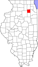
Adjacent counties:
Dekalb  Dupage  Grundy  Kane  La Salle  Will  

Find in Illinois

Map of the Kendall County area


Our detail map of Kendall County shows the Kendall County, Illinois boundary lines and other interesting items.

Places in Kendall County, Illinois

  Airports     show all on map

Bushby RLA Airport, Caterpillar Aurora Heliport, Flying M Farm Airport, Peterson Farms Airport, Riley's Field Airport, Rossi's Farm Airport, Updike Landing Strip, Vogen RLA Airport, Wheatland Field, Wiley Updike Airport, Wormley Airport

  Bridges     show all on map

Shurtliffe Bridge

  Buildings     show all on map

Beecher Community Building, Bristol - Kendall Fire Protection District Station 1, Bristol - Kendall Fire Protection District Station 2, Bristol - Kendall Fire Protection District Station 3, Head of the Grove, Joliet Fire Department Station 10, Kendall County Courthouse, Lisbon - Seward Fire Protection District 1, Lisbon - Seward Fire Protection District Station 2, Little Rock Fox Fire Department Station 1 Plano, Little Rock Fox Fire Department Station 2 Millbrook, Little White School Museum, Newark Ambulance District, Newark Fire Protection District, Oswego Fire Protection District Station 1, Oswego Fire Protection District Station 2, Oswego Fire Protection District Station 3, Oswego Fire Protection District Station 4, Oswego Public Library, Oswego Village Hall, Yorkville Public Library

  Cemeteries     show all on map

Albee Cemetery, Albert Hassel Cemetery, Bristol Burying Ground (historical), Chapman Cemetery, Collins Cemetery, Cowdrey Cemetery, Cross Lutheran Cemetery, Darnell Cemetery, Doud Cemetery, Elmwood Cemetery, Evergreen Cemetery, Fox Township Cemetery, Greefield Farm Cemetery, Griswold Cemetery, Helmar Lutheran Cemetery, Howland Cemetery, Hubbell Cemetery, Immanuel Lutheran Cemetery, Keck Memorial Cemetery, Lincoln Memorial Park, Lisbon Cemetery, Lyon Farm Cemetery, Millington-Newark Cemetery, Munger Cemetery, NaAuSay Cemetery, Oak Grove Cemetery, Oswego Cemetery, Oswego Prairie Cemetery, Oswego Township Cemetery, Ovitt Cemetery, Pavillion Cemetery, Pearce Cemetery, Plano Cemetery, Plattville Cemetery, Plattville Evangelical Lutheran Cemetery, Saint Patrick's Catholic Cemetery, Sandy Bluff Cemetery, Scott Cemetery, Shonts Cemetery, West Lisbon Lutheran Cemetery, Wormley Cemetery

  Census     show all on map

Boulder Hill Census Designated Place

  Churches     show all on map

Au Sable Grove Church, Bethlehem Lutheran Church, Bible Baptist Church, Bible Church, Bristol United Methodist Church, Christian Church of Oswegoland, Church of the Good Shepherd, Cross Lutheran Church, Emanuel Church, Gospel Assembly Church, Helmar Lutheran Church, Landmark Missionary Baptist Church, Lynwood Baptist Church, Neighborhood Church of the Brethren, New Life Assembly Church, Newark Lutheran Church, Oswego Prairie United Methodist Church, Oswego Presbyterian Church, Plano Christian Church, Plattville Lutheran Church, Plattville United Methodist Church, Reorganized Church of Jesus Christ of Latter Day Saints, Saint Annes Church, Saint Luke's Lutheran Church, Saint Patrick Catholic Church, Saint Patricks Parish Center, Valley Baptist Church, West Lisbon Lutheran Church, Yorkville Baptist Church, Yorkville Congregational Church, Yorkville United Methodist Church

  Dams     show all on map

Milhurst Lake Dam

  Hospitals     show all on map

Rush-Copley Healthcare Center

  Lakes     show all on map

Lake Plano

  Locales     show all on map

Brentwood Farm, Cedar Ridge Primitive Campground, Countryside Center Shopping Center, Fox Bend Golf Course, Fox Industrial Park, Fox View Picnic Area, Glen D Palmer State Game Farm, Marina Shopping Center, Oswego Station (historical), Settlers Landing Mall Shopping Center, Tall Oaks Picnic Area, Townes Crossing Shopping Center, Tukaway Farm

  Mines     show all on map

Central Quarry

  Parks     show all on map

Augusta Lake Park, Baker County Forest Preserve, Briarcliff Woods Park, Civic Center Park, Foli Park, Harris County Forest Preserve, Heritage Park, Houses Grove Forest Preserve, Jaycee Park, John Moore Park, Klatt Field, Lyon County Forest Preserve, Maramach Forest Preserve, Maramech Woods Nature Preserve, Millhurst Fen Nature Preserve, Northampton Park, Saw Wee Kee Park, Silver Springs State Park, Stonegate Park, Susan John Park, Violet Patch Park, Waa Kee Sha Park, Winrock Park, Yorkville City Park, Yorkville Prairie Nature Preserve

  Populated Places     show all on map

Ament Corners, Boulder Hill, Bristol, Central, Countryside, Fox, Helmar, Kentland, Knob Hill, Lisbon, Lisbon Center, Little Rock, Lynwood, Millbrook, Millhurst, Millington, Mount Vernon, Newark, Oswego, Pavillion, Plano, Plattville, White Willow (historical), Wolfs, Yorkville

  Post Offices     show all on map

Bristol Post Office, Kendall Post Office (historical), Millbrook Post Office, Oswego Post Office, Plano Post Office, White Willow Post Office (historical), Yorkville Post Office

  Reservoirs     show all on map

Beaver Lake, Loon Lake, Milhurst Lake

  Schools     show all on map

Anderson School (historical), Bell School (historical), Bethel School (historical), Boomer School (historical), Booth School (historical), Boulder Hill Elementary School, Bristol Grade School, Bronk School (historical), Brown School (historical), Centennial Elementary School, Chapman School (historical), Cherry School (historical), Circle Center Middle School, Collins School (historical), Cross School, Cutler School (historical), East View Elementary School, Emanuel School (historical), Faxon School, Fern Dell School (historical), Gaylord School (historical), Gorton School (historical), Greenfield School (historical), Harvey School (historical), Heap School (historical), Heddleson School (historical), Henderson School (historical), Hollenback School (historical), Jones School (historical), Keck School (historical), Kendall School (historical), Lisbon Grade School, Lisbon School, Long Beach Elementary School, Martin School (historical), Martner School (historical), Marysville School (historical), McCauley School (historical), McKanna School (historical), Millbrook Junior High School, Minkler School (historical), Naden School (historical), Needham School (historical), Newark Community High School, Newark Elementary School, Oswego High School, P H Miller Elementary School, Parkview Grade School (historical), Plano High School, Plano Middle School, Plecher School, Raymond School (historical), Richard School (historical), Russell School (historical), Saint Marys School, Sandy Bluff School (historical), Scott School (historical), Sears School (historical), Sleezer School (historical), Squires School (historical), Stephens School (historical), Thompson Junior High School, Traughber Junior High School, Union School (historical), Walker School (historical), Waubonsee College-Yorkville Campus, Weeks School (historical), White Willow School (historical), Wilcox School (historical), Willow Hill School, Wormely School (historical), Wyne School (historical), Yorkville Grade School, Yorkville High School

  Streams     show all on map

Ackleys Run, Big Rock Creek, Blackberry Creek, Clear Creek, East Aux Sable Creek, Hollenback Creek, Knutson Creek, Lisbon Creek, Little Rock Creek, Little Slough Creek, Middle Aux Sable Creek, Morgan Creek, Rob Roy Creek, Waubonsie Creek, West Aux Sable Creek

  Summits     show all on map

Maramech Hill

  Swamps     show all on map

Big Slough (historical)

  Towers     show all on map

WAUR-AM (Sandwich), WSPY-FM (Plano)

  Trails     show all on map

Beaver Dam Hiking and Cross-Country Ski Trail, Fox Ridge Nature Trail, Prairie View Equestrian Trail

  Woods     show all on map

Apakeska Grove (historical), Aux Sable Grove (historical), Big Grove (historical), Collins Grove (historical), Holdermans Grove (historical), Kelloggs Grove, Lone Tree Grove, Long Grove, Pappoose Grove, Specie Grove,

Kendall County, Illinois Population By Race (2012 estimate)

RacePopulation
WhiteKendall County White population 104,289104,289  
BlackKendall County Black population 7,2057,204
AsianKendall County Asian population 3,8983,897
MixedKendall County Mixed population 2,1262,125
American IndianKendall County American Indian population 472472
Hawaiian & Pacific IslanderKendall County Hawaiian & Pacific Islander population 00

Additional population tables :
State population table
Illinois population by county