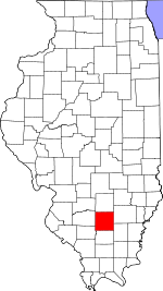
Jefferson County, Illinois Basics:
Jefferson County Illinois - Government Site
Population: 38,677
Area: 571 square miles
County seat: Mount Vernon
Area code(s) in use: 618
Time zone: CST
High school graduate or higher: 86.9%
Bachelor's degree or higher: 15.9%
Median household income: $42,272
Persons in poverty: 16.4%
Home ownership rate: 73.2%
Mean travel time to work: 19.7 minutes
Adjacent counties:
Franklin Hamilton Marion Perry Washington Wayne
Places in Jefferson County, Illinois
Davy Jones (Private) Airport,
Good Samaritan Regional Health Care Center Heliport,
Mount Vernon Airport,
Mount Vernon Bullock Heliport,
Prairie Airport Rock Bridge Air Evac Lifeteam 11,
Bald Hill Townhall,
Belle Rive Fire Department,
Big Muddy River Correctional Center,
Blissville Polling House (historical),
Blissville Townhall,
C E Brehm Memorial Library,
Carl L Schweinfurth Museum and Interpretive Center,
Cedarhurst Cultural Center,
Fifth District Appellate Court,
Jefferson County Animal Shelter,
Jefferson County Courthouse,
Jefferson Fire Protection District,
Jefferson Fire Protection District Station 2,
Jefferson Fire Protection District Station 3,
Jefferson Fire Protection District Station 4,
Litton Ambulance Service,
McClellan Townhall,
Moores Prairie Townhall,
Mount Vernon City Hall,
Mount Vernon Fire Department,
Mount Vernon Fire Department Station 2,
Mount Vernon Fire Department Station 3,
Mount Vernon Fire Department Station 4,
Rolland W Lewis Community Center,
Vantage Point Substance Abuse Services Center,
Waltonville Fire Protection District,
Webber Township Fire Protection District,
Woodlawn Fire Protection District Casey Ditch Abner Cemetery, Adams Farm Cemetery,
Antioch Cemetery,
Arnold Cemetery,
Atkinson Cemetery,
Bald Hill Cemetery, Baldridge Cemetery, Baldwin Farm Cemetery, Bell River Cemetery,
Bethel Memorial Cemetery,
Black Cemetery,
Black Oak Ridge Cemetery, Bond Cemetery, Boswell Cemetery,
Boyd Cemetery,
Boyd Farm Cemetery, Boyette Cemetery, Bradford Cemetery, Brown Farm Cemetery, Buffington Cemetery, Calvary Cemetery,
Carroll Cemetery, Casner Cemetery,
Clampet Cemetery,
Clark Cemetery, Clark Farm Cemetery, Cockran Farm Cemetery, County Farm Cemetery, Creel Cemetery,
Cub Prairie Cemetery, Davenport Cemetery, Delashment Cemetery, Dodds Cemetery,
Dryden Cemetery,
East Hickory Hill Cemetery,
East Salem Cemetery,
Ebenezer Cemetery,
Etheridge Cemetery,
Falley Cemetery, Feltz Farm Cemetery, Fisher Farm Cemetery,
Fitzgerrell Cemetery,
Flint Cemetery,
Four Graves,
Fouts Cemetery,
Gaston Cemetery,
Gilbert Cemetery,
Gilead Cemetery,
Gilead Cemetery,
Greenwalt Cemetery,
Grothoff Cemetery,
Hall Cemetery,
Hams Grove Cemetery, Harlow Cemetery,
Harmony Cemetery,
Hickey Cemetery,
Hicory Hill Cemetery,
Hope Cemetery,
Hopewell Cemetery, Horse Prairie Cemetery, Howe Cemetery,
Jennings Farm Cemetery,
Jordan Chapel Cemetery, Kell Cemetery,
Kirk Cemetery,
Knob Prairie Cemetery,
Knowles Cemetery,
Laird Cemetery,
Little Grove Cemetery,
Locust Grove Cemetery, Long Farm Cemetery,
Lowery Cemetery,
Lowry Hill Cemetery,
Mason Cemetery,
McConnaughhay Cemetery,
Meddows Cemetery,
Memorial Garden Cemetery,
Mifflin Cemetery,
Minson Cemetery,
Mount Catherine Cemetery,
Mount Olive Cemetery,
Mount Zion Cemetery,
Mount Zion Cemetery,
New Hope Cemetery,
New Shiloh Cemetery,
Newton Farm Cemetery,
Oak Dale Cemetery,
Oak Grove Cemetery,
Oakwood Cemetery,
Oddfellows Cemetery,
Old Baptist Cemetery,
Old Orchard Cemetery,
Old Panther Fork Cemetery,
Old Shiloh Cemetery,
Old Union Cemetery,
Opdyke Cemetery,
Panther Fork Cemetery,
Piskey Cemetery,
Pleasant Grove Cemetery,
Pleasant Hill Cemetery,
Quinn Cemetery,
Randolph Cemetery,
Rentchler Cemetery,
Reynolds Cemetery,
Richardson Farm Cemetery,
Rightnower Cemetery,
Round Knob Cemetery,
Saint Barbara Cemetery,
Saint Marys Cemetery,
Shelton Cemetery,
Shelton Cemetery,
Slade Cemetery,
Smith Cemetery,
Smith Cemetery,
South Hickory Hill Cemetery,
Stephens Cemetery,
Sugar Camp Cemetery,
Sunset Memorial Cemetery,
Taylor Cemetery,
Union Chapel Cemetery,
Wall Farm Cemetery,
Ward Cemetery,
Warren Cemetery,
Wells Chapel Cemetery,
West Salem Cemetery,
Wilbanks Cemetery,
Williams Cemetery,
Wolf Prairie Cemetery Opdyke Census Designated Place Antioch Church,
Antioch Church,
Bethany Church (historical),
Bethel Church,
Bethel Tabernacle Church,
Blackwell Temple African Methodist Episcopal Zion Church,
Camp Ground Baptist Church,
Casey Avenue Baptist Church,
Central Church of Christ,
Church of Christ,
Church of God,
Church of God,
Church of Jesus Christ,
Community Church,
Corinthian Baptist Church,
East Salem Baptist Church,
Eastside Baptist Church,
Elk Prairie Church,
Epworth United Methodist Church,
Faith Lutheran Church,
First Baptist Church,
First Baptist Church of Bluford,
First Church of the Nazarene,
First General Baptist Church,
First Presbyterian Church,
First United Methodist Church,
Fouts Church,
Free Methodist Church,
Freewill Baptist Church,
Full Gospel Tabernacle,
Gilead Church,
Hams Grove Church,
Hickory Hill Church,
Hoits Church,
Hopewell Church,
Howard Chapel,
Laird Church,
Lebanon Baptist Church,
Liberty Church,
Little Grove Church,
Lively Stone Apostolic Church,
Lively Stone Pentecostal Church (historical),
Logan Street Baptist Church,
Long Prairie Church,
Marcoe Church,
Meadowbrook Christian Church,
Minson Church (historical),
Moores Prairie Church,
Mount Catherine Church,
Mount Olive Church,
Mount Pisgah Church,
Mount Zion Church,
Mount Zion Church,
New Home Church,
New Hope Church,
New Hope Church,
Oak Grove Church,
Oak Grove Church,
Oakdale Church,
Oakland Church,
Old Shiloh Church (historical),
Old Union Missionary Baptist Church,
Panther Fork Church,
Park Avenue Baptist Church,
Pentecostal Revival Center,
Pilgrim Rest Baptist Church,
Pleasant Grove Church,
Pleasant Hill Church,
Pleasant View Church,
Primitive Church,
Providence Church,
Reorganized Church of Jesus Christ of Latter Day Saints,
Saint Marys Roman Catholic Church,
Second Baptist Church,
Second General Baptist Church (historical),
Seventh Day Adventist Church,
Shiloh Baptist Church (historical),
Shiloh Church,
Solid Rock Church of God,
South Hickory Hill Church,
South Side Baptist Church,
Springer Church,
Sugar Camp Church,
Summersville Baptist Church,
Trinity Episcopal Church,
Union Chapel,
Union Church,
United Brethren Church (historical),
Wells Chapel,
Wesley Methodist Church (historical),
Wesley United Methodist Church,
West Salem Trinity United Methodist Church,
West Side Baptist Church,
White Swan Church,
Wolf Prairie Church (historical),
Zion Church Interchange 103,
Interchange 69,
Interchange 73,
Interchange 78,
Interchange 80,
Interchange 83,
Interchange 89,
Interchange 92,
Interchange 95,
Interchange 96 Auxiliary Reservoir Impoundment Structure Dam,
Big Muddy Subimpoundment Dam,
Casey Fork Subimpoundment Dam,
East Lake Impoundment Dam,
Hawthorne Hills Lake Dam,
Illinois Central Reservoir Dam,
Illinois No Name Number 2014 Dam,
Illinois No Name Number 2016 Dam,
L and N Reservoir Dam,
Lake Jaycee Dam,
Lake Normandy Dam,
Miller Lake Dam,
Number 2 Portal Lake Dam,
O'Daniel Lodge Lake Dam Number 1,
O'Daniel Lodge Lake Dam Number 2,
Raw Water Reservoir Dam,
Superior Lake Dam,
Waltonville Lake Dam Crossroads Community Hospital,
Jefferson County Memorial Hospital,
Mount Vernon State Tuberculosis Sanitarium,
Saint Marys Good Samaritan Regional Health Center Scheller Lakes Cherry Creek Golf Center,
Fortysecond Street Plaza Shopping Center,
Fountain Place Industrial Park,
Green Hills Country Club,
Holiness Camp,
Homestead Hills Country Club,
Indian Hills Country Club,
King City Square Shopping Center,
Mount Vernon Wastewater Treatment Facility,
Park Plaza Shopping Center,
Rend Lake Camp,
Times Square Mall Shopping Center Inland Mine,
Orient Number 3 Mine,
Orient Number 6 Mine Bluford Oil Field,
Boyd Oil Field,
Coil West Oil Field,
Cravat Oil Field,
Cravat West Oil Field,
Divide Oil Field,
Dix Oil Field,
East Divide Oil Field,
Irvington East Oil Field,
King Oil Field,
Markham City Oil Field,
Markham City Oil Field,
Woodlawn Oil Field A L Dawson Senior Park,
Airport Park,
Bob Strothman Baseball Park,
Bonnie Public Use Area,
Fairmont Ballpark,
Highland Park,
Jefferson County Fairground,
Mount Vernon State Game Farm,
Nason Public Use Area,
Optimist Park,
Rend Lake State Waterfowl Management Area,
Rend Lake State Wildlife Refuge,
Waltonville Public Use Area Bakerville,
Baldwin Heights,
Belle Rive,
Bluford,
Bonnie,
Boyd,
Camp Ground,
Cravat,
Dareville,
Divide,
Dix,
Drivers,
Emerson City,
Fitzgerrell (historical),
Harmony,
Harris Grove (historical), Horse Prairie (historical),
Idlewood,
Ina,
Jefferson City,
Lynchburg (historical),
Marcoe,
Markham City,
Marlow,
Morganville,
Mount Vernon,
Nason,
Opdyke,
Pigeon (historical),
Roaches,
Scheller,
Shields,
Shirley,
Spring Garden,
Stratton,
Summersville,
Texico,
Waltonville,
Webster Hill Estates,
Williamsburg,
Woodlawn Fitzgerrell Post Office (historical),
Grand Arm Post Office (historical),
Logansville Post Office (historical),
Moores Prairie Post Office (historical),
Mount Vernon Post Office,
Opdyke Post Office,
Scheller Post Office Auxiliary Reservoir,
East Lake Impoundment,
Hawthorne Hills Lake,
Illinois Central Reservoir,
Lake Jaycee,
Lake Normandy,
Louisville and Nashville Reservoir,
Miller Lake,
Number 2 Portal Lake,
O'Daniel Lodge Lake,
O'Daniel Lodge Lake,
Peckerwood Lake,
Raw Water Reservoir,
Superior Lake,
Waltonville Lake Arlington School (historical),
Bald Hill School (historical),
Baldridge School (historical),
Barren School (historical),
Bell Point School (historical),
Belle Rive Attendence Center,
Bethel Grade School,
Birkhead School (historical),
Blackoak School (historical),
Block School (historical),
Bluford Elementary School,
Booker T Washington Grade School (historical),
Breeze School (historical),
Brush College School (historical),
Burlington School (historical),
Camp Ground School (historical),
Carful School (historical),
Carter School (historical),
Casey Junior High School,
Casner School (historical),
Center School (historical),
Centerville School (historical),
Central School (historical),
Central School (historical),
Clay Hill School (historical),
Climax School (historical),
Coats College School (historical),
College School (historical),
Copple School (historical),
Crossroads School (historical),
Dees School (historical),
Doctor Andy Hall Elementary School,
Dodds Elementary School,
Dryden School (historical),
Ebenezer School (historical),
Edison School,
Fairplay School (historical),
Farrington Elementary School,
Farrington School (historical),
Farrington School (historical),
Field Elementary School,
Forest Hill School (historical),
Four Corners School (historical),
Four Corners School (historical),
Franklin Elementary School,
Frog Ridge School (historical),
George College School (historical),
Gold Hill School (historical),
Grand Prairie Elementary School,
Green College School (historical),
Green School (historical),
Ham Grove School (historical),
Harlow School (historical),
Hawkins School (historical),
Hebron School (historical),
Hickory Hill School (historical),
Hickory Hill School (historical),
Hopewell School (historical),
Hopper School (historical),
Horace Mann Elementary School,
Howard School (historical),
Howe School (historical),
Hungry Hill School (historical),
Ina Community Consolidated School,
J L Buford Elementary School,
Laurel Hill School (historical),
Liberty School (historical),
Lincoln Elementary School,
Little Grove School (historical),
Locust Grove School (historical),
Lone Oak School (historical),
Lynchburg School (historical),
Maple Grove School (historical),
Maple Grove School (historical),
McClellan Elementary School,
McLaughlin School (historical),
Milliner School (historical),
Mount Pleasant School (historical),
Mount Vernon High School,
Mulberry School (historical),
Myer School (historical),
New Bradford School (historical),
New Hope School (historical),
Number Nine School (historical),
Oak Grove School (historical),
Oak Grove School (historical),
Oak Grove School (historical),
Oak Grove School (historical),
Oak Ridge School (historical),
Oakdale School (historical),
Oakland School (historical),
Old Union School,
Opdyke Attendance Center,
Osborne School (historical),
Pleasant Grove School (historical),
Pleasant Grove School (historical),
Pleasant Hill School (historical),
Pleasant Valley School (historical),
Pleasant View School (historical),
Post Oak School (historical),
Progress School (historical),
Rapp School (historical),
Rend Lake College,
Rightnowar School (historical),
Riley School (historical),
Robinson School (historical),
Rome Community Consolidated Elementary School,
Rosewood School (historical),
Ross Hill School (historical),
Saint Elmo School (historical),
Saint Marys School,
Sanders School (historical),
Science School (historical),
Shady Grove School (historical),
Shiloh School (historical),
Simmons School (historical),
Springer School (historical),
Summersville Grade School,
Toney Point School (historical),
Union Grove School (historical),
Utah School (historical),
Valley Breeze School (historical),
Waltonville Grade School,
Waltonville High School,
Webb School (historical),
Webber Grove School (historical),
Webber Township High School,
West Salem School,
White Swan School (historical),
Whiteoak School (historical),
Whiteoak School (historical),
Williams School (historical),
Williamson School (historical),
Witherspoon School (historical),
Wolf Prairie School (historical),
Woodlawn Community High Shool,
Woodlawn School,
Woods School (historical) Akward Creek,
Atchison Creek,
Back Branch,
Bald Hill Creek,
Bear Creek,
Buck Creek,
Coal Bank Creek,
Cub Branch,
Dodds Creek,
East Creek,
East Hurricane Creek,
Harlow Creek,
Harper Creek,
Hartley Branch,
Hurricane Creek,
Jones Branch,
Knob Prairie Creek,
Limestone Creek,
Novak Creek,
Panther Fork,
Pierce Creek,
Pigeon Creek,
Poplar Branch,
Puncheon Creek,
Rayse Creek,
Rocky Branch,
Sevenmile Creek,
Snow Creek,
Twomile Creek,
Ward Branch,
West Creek,
White Feather Creek Lowry Hill,
The Pinnacle WMIX-AM (Mount Vernon),
WMIX-AM (Mount Vernon),
WMIX-FM (Mount Vernon),
WUID-FM (Woodlawn),

