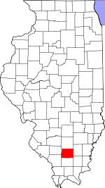
Franklin County, Illinois Basics:


Franklin County Illinois - Government Site

Population: 39,482
Area: 409 square miles
County seat: Benton
Area code(s) in use: 618
Time zone: CST
High school graduate or higher: 86.8%
Bachelor's degree or higher: 12.9%
Median household income: $37,158
Persons in poverty: 18.8%
Home ownership rate: 77.3%
Mean travel time to work: 24.1 minutes


Adjacent counties:
Hamilton  Jackson  Jefferson  Perry  Saline  Williamson  

Find in Illinois

Map of the Franklin County area


Our detail map of Franklin County shows the Franklin County, Illinois boundary lines and other interesting items.

Places in Franklin County, Illinois

  Airports     show all on map

Adams Private Airport, Benton Municipal Airport, Bessie RLA Airport, Rend Lake Conservancy District Heliport

  Bridges     show all on map

Gallaway Bridge (historical), Jackson Bridge

  Buildings     show all on map

Barren Townhall, Benton Ambulance Service, Benton Civic Center, Benton Fire Department, Benton Public Library, Benton Township Gymnasium, Buckner Volunteer Fire Department, Cave Eastern Fire Protection District Station 1, Cave Eastern Fire Protection District Station 2, Christopher Fire Department, Coello Volunteer Fire Department, Ewing - Northern Fire Protection District Station 1, Ewing - Northern Fire Protection District Station 2, Ewing - Northern Fire Protection District Station 3, Franklin County Courthouse, Franklin County Jail, Mercy Regional Health System, Royalton Volunteer Fire Department, Sesser Fire Protection District, Sesser Fire Protection District Station 2, United Jewish Community Center, Valier Fire Department, West City Fire Department, West Frankfort City Hall, West Frankfort Fire Department, West Frankfort Public Library, Zeigler Fire Department

  Cemeteries     show all on map

Baxter Cemetery, Bear Point Cemetery, Bonner Cemetery, Brady Cemetery, Browning Cemetery, Browning Cemetery, Browning Cemetery, Butler Cemetery, Clayton Cemetery, Clem Cemetery, Cook Cemetery, Cook Cemetery, County Cemetery, County Farm Cemetery, Crawford Cemetery, Cypher Cemetery, Dawson Cemetery, Denning Cemetery, Downs Cemetery, Drummond Cemetery, Follis Cemetery, Franklin Cemetery, Franklin Cemetery, Gilgal Cemetery, Grammer Cemetery, Greenwood Cemetery, Hammond Cemetery, Hanes Cemetery, Harrison Cemetery, Hickory Corners Cemetery, Isaacs Cemetery, Jacksonville Cemetery, Jones Cemetery, Joplin Cemetery, King Cemetery, Knight Cemetery, Lithuanian Cemetery, Manion Cemetery, Maple Hill Cemetery, Masonic-Oddfellow Cemetery, Melvin Cemetery, Memorial Park Cemetery, Middle Fork Cemetery, Miller Cemetery, Miners Cemetery, Miners Cemetery, Mitchell Cemetery, Moser Cemetery, Moyers Cemetery, Mulkeytown Cemetery, Naylor Cemetery, Neal Cemetery, Neal Cemetery, New Union Cemetery, Oddfellow Cemetery, Old Mulkeytown Cemetery, Osage Cemetery, Otterson Cemetery, Overturf Cemetery, Phillips Cemetery, Rea Cemetery, Reed Cemetery, Rose Cemetery, Saint Aloysius Cemetery, Saint Andrews Cemetery, Saint Johns Cemetery, Saint Joseph Cemetery, Saint Marys Cemetery, Saint Marys Cemetery, Shiloh Cemetery, Smith Cemetery, Smith Cemetery, Smothers Cemetery, Swofford Cemetery, Thurmond Cemetery, Tower Height Cemetery, Trinity Cemetery, Vaughn Cemetery, Walnut Grove Cemetery, Ward Cemetery, Wayman Cemetery, Wells Cemetery, Winemiller Cemetery, Youngblood Cemetery, Zeigler Cemetery

  Census     show all on map

Mulkeytown Census Designated Place

  Churches     show all on map

Antioch Church, Apostolic Church, Apostolic Church of Royalton, Apostolic Faith Assembly Church, Assembly of God Church, Bear Point Church, Benton Christian Church, Bethel Church, Bethel Church, Bethel Church (historical), Bible Way Revival Center, Boner Chapel, Buggtussel Church, Caldwell Church, Calvary Southern Baptist Church, Carters Temple, Central United Methodist Church, Church of Christ, Church of Christ, Church of Christ, Church of God, Church of God, Church of God, Community Church, Creek Nation Church, Eakin Grove Church, East Benton Baptist Church, East Fork Church, First Apostolic Church, First Baptist Church, First Baptist Church, First Baptist Church of Benton, First Christian Church, First Christian Church, First Christian Church, First Christian Church, First Church of Christ Scientist, First Church of God, First Church of the Nazarene, First Church of the Nazarene, First Free Will Baptist Church, First Northern Baptist Church, First Presbyterian Church, First United Methodist Church, First United Methodist Church, First United Methodist Church, Forest Church, Glad Tidings Church, Greenwood Church, Harmony Church, Harmony Free Baptist Church (historical), Hazel Dell Free Will Baptist Church, Heights Church of God, Holy Protection Orthodox Church, Horse Prairie Baptist Church, Immanuel Baptist Church, Jackson Grove Baptist Church, Kingdom Hall of Jehovahs Witnesses, Knob Prairie Church, Liberty Church, Liberty Church, Minor Church, Mormon Church (historical), Mount Etna Church, Mount Olive Church, Mount Pleasant Church, Mount Zion Church, Mount Zion Church, New Beginnings Free Will Baptist Church, New Hope Church, North Benton Missionary Baptist Church, Oak Hill Church, Palestine Church, Plaster Grove Church, Pleasant Hill Church, Rescue Church, Saint Aloysius Catholic Church, Saint Johns Roman Catholic Church, Saint Joseph Catholic Church, Saint Marks Episcopal Church, Saint Marys Catholic Church, Saint Pauls Lutheran Church, Salem Church, Second Baptist Church, Shiloh Church (historical), Sixmile Church (historical), Third Baptist Church, Townmount Church, Trinity Baptist Church, Trinity United Methodist Church, Union Church, Walnut Grove Church (historical), Webbs Prairie Church, Wesleyan Church, West City First Baptist Church, Westminister Presbyterian Church, White Oak Church, Williams Chapel, Zeigler Christian Church

  Cliffs     show all on map

Bluebell Bluff

  Crossings     show all on map

Interchange 65, Interchange 71, Interchange 77

  Dams     show all on map

Beaver Lake Dam, Buckner Reservoir Dam, Cambon Lake Dam, Christopher New Reservoir Dam, Christopher Old Reservoir Dam, City of Sesser Reservoir Dam, Illinois No Name Number 3 Dam, Illinois No Name Number 63 Dam, Lake Benton Dam, Lake Hamilton Dam, Lake Helen Dam, Lake Moses Dam, Mine Number 21 Dam, New City Lake Dam, Old City Lake Dam, Rend Lake Dam, Valier Lake Dam, Zeigler City Lake Dam

  Hospitals     show all on map

Franklin Hospital, Miners Hospital, Miners Memorial Health Center, Moore Hospital (historical)

  Lakes     show all on map

B and A Lake, Buckner Pond, Buster Pond, Vernons Lake, West Frankfort City Lake

  Locales     show all on map

Airport Industrial Park, Benton Country Club, Frankfort Community Park, Lake Benton Camp, Odum Spur, Rend Lake Marina, Rend Lake Plaza Shopping Center, Royalton Waterworks, University of Illinois Experimental Farm, West Frankfort Water Works, Whispering Pines Group Camp

  Mines     show all on map

Old Ben Number 21 Mine, Old Ben Number 21 Mine, Old Ben Number 24 Mine, Old Ben Number 26 Mine, Old Ben Number 26 Mine, Old Keller Mine, Orient Number 5 Mine

  Oilfields     show all on map

Benton North Oil Field, Benton Oil Field, Sesser Oil Field, West Frankfort Oil Field, West Frankfort South Oil Field, Whittington Oil Field, Zeigler Oil Field

  Parks     show all on map

Benton City Park, Franklin County Fairground, Gun Creek Public Use Area, Marcum Branch North Public Use Area, Marcum Branch South Public Use Area, Rend Lake Dam West Public Use Area, Sandusky Creek North Public Use Area, Sandusky Creek South Public Use Area, Sandusky Creek South Public Use Area, Sandusky Creek West Public Use Area, Sesser Public Use Area, Spillway Public Use Area, Super-Koll Park, Wayne Fitzgerrell State Park

  Populated Places     show all on map

Akin, Akin Junction, Benton, Benton Park, Bessie, Boothby, Buckner, Cambon, Christopher, Cleburne, Coello, Deering City, Diana, Ewing, Ferber, Frankfort, Frisco, Greenville (historical), Groat, Hickory Corners, Kegley, Lake Creek, Locust Grove (historical), Logan, Macedonia, Meyer, Mitchell, Mulkeytown, Orient, Parrish, Pershing, Plumfield, Rend City, Royalton, Rust, Sesser, Smothersville, Steel City, Taylor Hill, Thompsonville, Urbain, Valier, Valier Patch, West City, West Frankfort, Whittington, Zeigler

  Post Offices     show all on map

Akin Post Office, Benton Post Office, Big Muddy Post Office (historical), Eastern Post Office (historical), Fitts Hill Post Office (historical), Mulkeytown Post Office, Prosperity Post Office (historical), Taylor Hill Post Office (historical), Webbs Prairie Post Office (historical), West Frankfort Post Office

  Reservoirs     show all on map

Beaver Lake, Buckner Reservoir, Cambon Lake, Christopher Lake, Christopher New Reservoir, Christopher Reservoir, Hilyn Lake, Izaac Walton Lake, Lake Benton, Lake Hamilton, Lake Helen, Lake Moses, Mine Number 21 Reservoir, New City Lake, Old City Lake, Rend Lake, Sesser Lake, Thompsonville Lake, Valier Lake, Valier Mine Pond, West Frankfort Reservoir, Zeigler City Lake, Zeigler Reservoir

  Schools     show all on map

Accommodation School (historical), Akin Community Consolidated Elementary School, Arkansas School (historical), Barnes School (historical), Bear Point School (historical), Benton Consolidated High School, Benton Middle School, Bluegrass School (historical), Bucktown School (historical), Center School (historical), Central Junior High School, Central School (historical), Christopher Community High School, Christopher Elementary School, Clam School (historical), Conner College (historical), Coon Ridge School (historical), Corner School (historical), Crawford School (historical), Cuba School (historical), Denning Elementary School, Denning School (historical), Denning School (historical), Douglas Public School (historical), East Center School (historical), East Crown Point School (historical), Edwards School, Ewing-Northern Elementary School, Flatts School, Fourmile School (historical), Frankfort Elementary School, Frankfort High School, Franklin School, Franklin School (historical), Franklin School (historical), Grant Elementary School, Hazel Dell School (historical), Hickory Hill School (historical), Hill City School, Independence School (historical), Jacksonville School, Joiner School, Keller School (historical), King College (historical), King Creek School (historical), Knob Prairie School (historical), Lincoln School, Lincoln School, Logan Elementary School, Logan Public School (historical), Logan School, Long Branch School (historical), Long Prairie School (historical), Manion School (historical), Martin School (historical), McClasson School (historical), McGuire School (historical), Meyers School (historical), Moore School (historical), Mount Pleasant School (historical), Mount Zion School (historical), Neal School (historical), New Harmony School (historical), North School (historical), Old Akin School (historical), Orton School (historical), Palestine School (historical), Pierce School (historical), Pleasant Hill School (historical), Postoak School (historical), Robtown School (historical), Rodgers School (historical), Rollinson School (historical), Saint Andrews School, Saint Johns School, Saul School (historical), Sesser-Valier High School, Shiloh School (historical), South School (historical), Stockwell School (historical), Sugarcamp School (historical), Taylor Hill School (historical), Thistle Ridge School (historical), Thompsonville Grade School, Thompsonville High School, Union School (historical), Washington School, Webbs Prairie School (historical), Webster School, West Center School (historical), West Crown Point School (historical), West Franklin High School, Whiteoak School (historical), Wilson School

  Streams     show all on map

Akin Creek, Andy Creek, Cane Creek, Carlton Branch, Casey Fork, Drummond Branch, Ewing Creek, Fallet Branch, Gatling Branch, Goose Creek, Granny Creek, Green River, Gun Creek, Hamilton Branch, Jackie Branch, Jordan Creek, Little Bessie Creek, Little Indian Creek, Marcum Branch, Middle Fork Big Muddy River, Prairie Creek, Sandusky Creek, Stevens Creek, Sugar Camp Creek, Sugar Creek, Taylor Branch, Tilley Creek, Webbs Hill Branch, White Oak Creek

  Summits     show all on map

Browning Hill, Grammer Hill, Moores Hill, Turkey Knob, Webbs Hill

  Towers     show all on map

Benton Lookout Tower, Royalton Lookout Tower, WFRX-AM (West Frankfort), WFRX-FM (West Frankfort), WQRL-FM (Benton), WUEZ-FM (Christopher),

Franklin County, Illinois Population By Race (2012 estimate)

RacePopulation
WhiteFranklin County White population 38,57438,573  
MixedFranklin County Mixed population 434434
BlackFranklin County Black population 197197
AsianFranklin County Asian population 158157
American IndianFranklin County American Indian population 118118
Hawaiian & Pacific IslanderFranklin County Hawaiian & Pacific Islander population 00

Additional population tables :
State population table
Illinois population by county