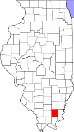
Saline County, Illinois Basics:
Saline County Illinois - Government Site
Population: 25,007
Area: 380 square miles
County seat: Harrisburg
Area code(s) in use: 618
Time zone: CST
High school graduate or higher: 83.9%
Bachelor's degree or higher: 13.8%
Median household income: $37,139
Persons in poverty: 18.6%
Home ownership rate: 73.2%
Mean travel time to work: 22.1 minutes
Adjacent counties:
Franklin Gallatin Hamilton Hardin Johnson Pope White Williamson
Places in Saline County, Illinois
Harrisburg Medical Center Heliport,
Harrisburg-Raleigh Airport,
Kerr-McGee Coal Corporation Heliport Carrier Mills Fire Department,
Eldorado City Hall,
Eldorado Fire Department,
Galatia Volunteer Fire and Rescue,
Harrisburg Fire Department,
Illinois Youth Center - Harrisburg,
Miller Emergency Medical Services,
Miller Emergency Medical Services,
Rector Townhall,
Saline County Ambulance Service,
Saline County Courthouse,
Stonefort Fire and Rescue,
Tate Townhall Abney Family Cemetery,
Abney Family Number 2 Cemetery,
Baker Family Cemetery, Bankston Cemetery, Baptist Cemetery,
Barton Family Cemetery, Big Ridge Church Cemetery,
Big Saline Church Cemetery,
Blackman Cemetery, Blackman Family Cemetery, Blake Family Cemetery,
Blockhouse Cemetery,
Bramlet Family Cemetery, Bramlet Family Cemetery,
Brooks Cemetery, Brothers Family Cemetery, Brushy Fork Cemetery,
Butler Family Cemetery, Cain Cemetery, Cain Family Cemetery, Calatia Cemetery,
Campground Cemetery,
Cardwell Cemetery, Carr Cemetery, Carrier Family Cemetery, Carter Family Cemetery, City of Harrisburg Cemetery,
Colbert Family Cemetery, Cottage Grove Cemetery, Courthouse Lawn Cemetery,
Dodd Family Cemetery, Dorrisville Cemetery, Douglas Cemetery, Duncan Cemetery, Duncan Family Cemetery,
Durham Cemetery,
Ebenezer Cemetery, Ebenezer Presbyterian Church Cemetery, Eldorado Cemetery, Evans Cemetery, Field Family Cemetery,
Gaines Family Cemetery, Garris Family Cemetery,
Gulley Cemetery,
Hall Town Cemetery,
Jenny Ridge Cemetery,
Jones Cemetery,
Joyner Cemetery,
Kious Cemetery,
Lambert Family Cemetery,
Ledford Family Cemetery,
Lindale Memorial Gardens,
McFarland Cemetery,
Moore-Vinson Family Cemetery,
Mount Pleasant Cemetery,
Old Ebenezer Cemetery,
Old Ruff Cemetery,
Read Family Cemetery,
Rhine Church Cemetery,
Rice Cemetery,
Saint Mary Cemetery,
Simpson Family Cemetery,
Stricklin Family Cemetery,
Sunset HillCemetery,
Trout Family Cemetery,
Tuttle Cemetery,
Wallace Family Cemetery,
Ward Cemetery,
Winkleman Cemetery,
Wolf Creek Primitive Baptist Church Cemetery Bethel Church,
Bethel Creek Church,
Beulah Heights Methodist Church (historical),
Big Ridge Church,
Big Saline Church,
Calvary Baptist Church,
Church of God of Eldorado,
College Heights Baptist Church,
Dallasania Church (historical),
Ebenezer Church (historical),
First Baptist Church,
First Church of Christ,
First Presbyterian Church,
First United Methodist Church,
Free Methodist Church,
Gospel Assembly Church,
Holy Bible Mission,
Ingram Hill Church,
Lakeview Church,
Lebanon Church,
Little Chapel,
Little Saline Church,
Lone Oak Church,
Macedonia Church,
Mount Grove Church,
Mount Moriah Church,
Mount Pleasant Church,
Mount Pleasant Church,
Mount Zion Church,
New Prospect Church,
Palestine Church,
Pleasant Grove Church,
Pleasant Valley Church,
Providence Church,
Reids Chapel,
Saint Mary Catholic Church,
Salem Church,
Saline Ridge Church,
Saline Valley Church,
Scott Street Baptist Church,
South America Church,
Spring Valley Church,
Star Church,
Sulphur Springs Church,
Tate Chapel,
Union Chapel,
Union Grove Church,
Walnut Grove Church,
Wesley Chapel Stone Face,
Stonefort Bluff Grocery Ford Eldorado Reservoir Dam,
Glen O Jones Lake Dam,
Harrisburg Reservoir Dam,
Harrisburg Reservoir Dam,
Illinois No Name Number 2026 Dam Davis Slough,
Setten Slough Ferrell Hospital,
Harrisburg Medical Center,
Lightner Hospital Berkel Lake,
Cottonwood Pond,
Gaskin Lake,
Lost Lake,
Open Pond,
Parker Lakes,
Snockey Pond Garden of the Gods Recreation Area,
Martin Swine Farm,
Pharaoh Camp and Picnic Area,
West End Disposal Facility Sahara Mine Number 16,
Sahara Mine Number 5,
Sahara Mine Number 7,
Vinyard Mine,
Wasson Mine Number 2 Eldorado Oil Field Carrier Mills Park,
Karel Park,
Mahoney Park,
Moores Grove Park,
Saline County State Conservation Area Beulah Heights,
Buena Vista,
Carrier Mills,
Cottage Grove,
Delta,
Derby,
Dorris Heights,
Dorrisville,
Eagle,
Eldorado,
Francis,
Galatia,
Garden Heights,
Gaskins City,
Halltown (historical),
Harco,
Harrisburg,
Horseshoe,
Ledford,
Liberty,
Long Branch,
Mitchellsville,
Muddy,
New Hope,
Newcastle,
Oldtown,
Pankeyville,
Raleigh,
Red Bud (historical),
Rudement,
Saline,
Saline City,
Saline Valley Store (historical),
Somerset,
Texas City,
Tison,
Wasson,
West End,
Whitesville (historical) Eldorado Post Office, Whiteside Post Office (historical)
Eagle Mountains Garden of the Gods Wilderness Eldorado Reservoir,
Glen Jones Lake,
Glen O Jones Lake,
Harrisburg Reservoir,
Willow Lake Big Ridge Arkansas School (historical),
Beulah Heights Public School (historical),
Bramlet School (historical),
Bunker Hill School (historical),
Cain School,
Cain School (historical),
Carrier Mills Elementary School,
Carrier Mills High School,
Cedar Point School (historical),
Chenault School (historical),
Colbert School,
Dorrisville School,
Duncan School (historical),
East Big Ridge School (historical),
East Ingram Hill School (historical),
East Side Grade School,
Ebenezer School (historical),
Eldorado High School,
Eldorado Middle School,
Fisher Bend School (historical),
Galatia Elementary Schools,
Galatia High School,
Hancock School,
Harris School (historical),
Harrisburg High School,
Henshaw School (historical),
Hillcrest School,
Holmes School (historical),
Independence School,
Jefferson School,
Jones School (historical),
Lake View School (historical),
Liberty School,
Lincoln Public School (historical),
Lincoln School,
Logan School,
Macedonia School (historical),
Malan Junior High School,
McKinley School,
New Hope School (historical),
Newcastle School (historical),
North Walnut School (historical),
Oakgrove School (historical),
Oldtown School (historical),
Pierson School (historical),
Possum Flat School (historical),
Rhine School (historical),
Rocky Branch School,
Sadler School (historical),
Saint Marys School,
Salem School (historical),
Saline Valley School (historical),
Shelton School (historical),
Smith School (historical),
South Walnut School (historical),
Southeastern Illinois College,
Spring Valley School (historical),
Taylor School (historical),
Union School (historical),
Ward School (historical),
West Big Ridge School (historical),
West Side Grade School,
West Sulphur School (historical),
Wiggins School (historical),
Winkeman School (historical) Bankston Fork,
Battle Ford Creek,
Black Slough,
Blackman Creek,
Brier Creek,
Brier Creek,
Brush Creek,
Brushy Creek,
De Neal Branch,
Gassaway Branch,
Grassy Creek,
Halltown Creek,
Indian Creek,
Little Saline River,
Long Branch,
Middle Fork Saline River,
Old Channel,
Pankey Branch,
Pond Creek,
Pruett Branch,
Rector Creek,
Rocky Branch,
Rocky Branch,
Rose Creek,
Sandy Branch,
South Fork Saline River,
Spring Valley Creek,
Wolf Creek Bald Knob,
Cave Hill,
Colbert Hill,
Horton Hill,
Murray Bluff,
Wamble Mountain WEBQ-AM (Harrisburg),
WEBQ-FM (Eldorado),
WUBS-AM (Harrisburg) River to River Trail,
River to River Trail Beech Hollow,
Bill Hill Hollow,
Blue Spring Hollow,
Buzzard Roost Hollow,
Cochran Hollow,
Dennison Hollow,
Flatrock Hollow,
Forwe Hollow,
Hargrave Hollow,
Horseshoe Hollow,
Lockwood Hollow,
Mud Springs Hollow,
Rocky Branch Hollow,
Stillhouse Hollow,
Three Springs Hollow,
Wiedeman Hollow,

