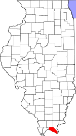
Massac County, Illinois Basics:


Massac County Illinois - Government Site

Population: 15,174
Area: 237 square miles
County seat: Metropolis
Area code(s) in use: 618
Time zone: CST
High school graduate or higher: 84.9%
Bachelor's degree or higher: 16.7%
Median household income: $42,190
Persons in poverty: 16.0%
Home ownership rate: 78.4%
Mean travel time to work: 20.8 minutes


Adjacent counties:
Ballard (KY)  Johnson  Livingston (KY)  McCracken (KY)  Pope  Pulaski  

Find in Illinois

Map of the Massac County area


Our detail map of Massac County shows the Massac County, Illinois boundary lines and other interesting items.

Places in Massac County, Illinois

  Airports     show all on map

Metropolis Municipal Airport

  Areas     show all on map

Devils Washboard

  Bends     show all on map

Black Bottom

  Bridges     show all on map

Irvin S Cobb Bridge

  Buildings     show all on map

Brookport Fire Department, Good Samaritan Nursing Home, Hillerman Rock Post Light, Joppa Fire Department, Joppa Generating Station, Massac County Courthouse, Massac County Fire Protection District Station 1, Massac County Fire Protection District Station 2, Massac Memorial Ambulance Service, Metropolis Fire Department, Metropolis Public Library

  Canals     show all on map

Bear Creek Ditch, Bucker Pond Ditch, Clifty Creek Ditch, Dry Ridge Ditch, Gurley Ditch, Main Ditch, New Columbia Ditch, Q Ditch, Sen Beck Ditch, Tucker Ditch

  Cemeteries     show all on map

Aikins Cemetery, Allard Cemetery, Armstrong Cemetery, Barrett Cemetery, Bethel Cemetery, Bigley Cemetery, Brookport Cemetery, Bumgardner Cemetery, Burnham Cemetery, Buzzard Roost Cemetery, Cagle Cemetery, Canaan Cemetery, Carr Cemetery, Clendenon Cemetery, Copland Cemetery, Curtis Cemetery, Douglas Cemetery, Fritts Cemetery, Golightly Cemetery, Hitchcock Cemetery, Howard Cemetery, Johnson Cemetery, Keckolie Cemetery, Kennedy Cemetery, Kidd Cemetery, Kingston Cemetery, Kirkendall Cemetery, Liberty Ridge Cemetery, Masonic Cemetery, Massac Memorial Gardens, Massonic Cemetery, McCormick Cemetery, Morrison Cemetery, Morse Cemetery, Mosley Cemetery, Murray Cemetery, Nineveh Cemetery, Odd Fellows Cemetery, Pell Cemetery, Poco Cemetery, Round Spring Cemetery, Westerman Cemetery, Wilkins Cemetery

  Churches     show all on map

Anderson Church, Broadway Church of Christ, Brookport United Methodist Church, Cherry Street Pentecostal Church, Church of Christ, Church of Christ, Church of God, Cumberland Church, Eastland Baptist Church, First Baptist Church, First Missionary Baptist Church, First United Methodist Church, Hillerman Church, Immanuel Baptist Church, Kingdom Hall Jehovahs Witnesses, Little Rock Church, Lower Salem Church, Lutheran Church of the Cross, Macedonia Church, Mount Hebron Church, Mount Horeb Freewilll Baptist Church, Mount Mission Church, Mount Pleasant Church, Mount Sterling Church, New Hope Church, Oak Grove Cumberland Presbyterian Church, Powers United Methodist Church, Saint Johns Church, Saint Johns Church, Saint Paul Lutheran Church, Saint Rose of Family Catholic Church, Seven Mile Baptist Church, Siloam Church, Trinity Presbyterian Church, Unity Missionary Baptist Church, Upper Salem Church, Waldo Baptist Church, Weaver Creek Church, Zion Church, Zion Church

  Cliffs     show all on map

Cagle Bluff, New Columbia Bluffs, Wildcat Bluff

  Crossings     show all on map

Interchange 37, Owens Ferry (historical)

  Dams     show all on map

Dam Number 52, Hohman Lake Dam, Mann Lake Dam

  Hospitals     show all on map

Massac Memorial Hospital

  Lakes     show all on map

Allard Lake, Beaverdam Lake, Brushy Lake, Cagle Pond, Hunnerkoch Lake, Kinneman Lake, Loon Lake, Old Bay, Round Lake (historical)

  Locales     show all on map

Courtney Spur, Fletchers Landing, Fort Massac Rest Area, Frontier Picnic Area, Long Knife Picnic Area, Metropolis Country Club, Musketeer Campground, Paducah and Illinois Fishing Camp, Pearcy Camp, Risinger Spur, River Forest Picnic Area

  Military     show all on map

Fort Massac (historical)

  Parks     show all on map

Fort Massac State Park, Franklin Park, Lincoln Park, Massac Forest Nature Preserve, Memorial Park, Mermet Lake State Conservation Area, Mermet Swamp Nature Preserve, Washington Park

  Pillars     show all on map

Hillerman Rock

  Populated Places     show all on map

Big Bay, Boaz, Brookport, Choat, Grinnell, Hillerman, Joppa, Massac City, Mermet, Metropolis, Midway, New Columbia, Round Knob, Samoth, Shady Grove, Unionville

  Post Offices     show all on map

Ash Ridge Post Office (historical), Metropolis Post Office

  Reservoirs     show all on map

Hohman Lake, Mann Lake, Mermet Lake, Oak Glen Lake

  Ridges     show all on map

Gray Ridge, Redbird Ridge

  Schools     show all on map

Aikins School (historical), Anderson School (historical), Benton School (historical), Bethlehem School (historical), Black Bottom School (historical), Black Hill School (historical), Brookport Elemenatary School, Central Elementary School, Central School (historical), Clifty Creek School (historical), Enterprise School (historical), Fairview School (historical), Franklin Elementary School, George R Clark Elementary School, Glenwood School (historical), Good Hope School (historical), Independence School (historical), Jefferson Elementary School, Joppa High School, Lincoln School, Little Park School (historical), Logan School Number 6, Maple Grove Elementary School, Massac County High School, Metropolis Junior High School, Metropolis Middle School, Mount Mission School (historical), Mount Pleasant School (historical), Neely School (historical), Oak Grove School (historical), Palmar School (historical), Pleasant Grove School (historical), Pleasant Union School (historical), Point Pleasant School (historical), Powers School (historical), Round Spring School (historical), Saint Rose School, Shady Grove School (historical), Tucker School (historical), Union School (historical), Unity Elementary School, Upper Union School (historical), Washington School, Washington School (historical), Weaver Creek School (historical)

  Springs     show all on map

Mill Spring

  Streams     show all on map

Barnes Creek, Bayou Creek, Bear Creek, Cave Creek, Clifty Creek, Crenshaw Creek, Fourmile Creek, Georges Creek, Mallard Creek, Massac Creek, Mud Creek, Mud Creek, Patterson Branch, Rocky Branch, Sevenmile Creek, Weaver Creek

  Summits     show all on map

Kincaid Mounds, Round Knob

  Towers     show all on map

WMOK-AM (Metropolis), WREZ-FM (Metropolis), WRIK-AM (Brookport), WRIK-FM (Metropolis),

Massac County, Illinois Population By Race (2012 estimate)

RacePopulation
WhiteMassac County White population 13,89913,899  
BlackMassac County Black population 880880
MixedMassac County Mixed population 288288
American IndianMassac County American Indian population 6160
AsianMassac County Asian population 4645
Hawaiian & Pacific IslanderMassac County Hawaiian & Pacific Islander population 00

Additional population tables :
State population table
Illinois population by county