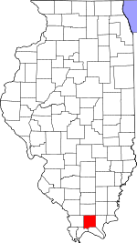
Johnson County, Illinois Basics:


Johnson County Illinois - Government Site

Population: 12,786
Area: 344 square miles
County seat: Vienna
Area code(s) in use: 618
Time zone: CST
High school graduate or higher: 81.7%
Bachelor's degree or higher: 14.9%
Median household income: $42,027
Persons in poverty: 11.3%
Home ownership rate: 82.9%
Mean travel time to work: 26.2 minutes


Adjacent counties:
Massac  Pope  Pulaski  Saline  Union  Williamson  

Find in Illinois

Map of the Johnson County area


Our detail map of Johnson County shows the Johnson County, Illinois boundary lines and other interesting items.

Places in Johnson County, Illinois

  Airports     show all on map

Covey Airport, Kellums Airport, Vienna Correctional Center Heliport

  Arches     show all on map

Cedar Wonders Arch, Rainbow Arch

  Bays     show all on map

Bethlehem Bay, Shawnee Bay

  Buildings     show all on map

Belknap Volunteer Fire Department, Buncombe Volunteer Fire Department, Carnegie Library, Cypress Volunteer Fire Department, Goreville Volunteer Fire Department, Johnson County Ambulance Service, Johnson County Courthouse, Lake Egypt Fire Protection District Station 2, Lake Egypt Fire Protection District Station 3, New Burnside Fire Protection District, Shawnee Correctional Center, Vienna Correctional Center, Vienna Correctional Center, Vienna Volunteer Fire Department

  Canals     show all on map

Gann Ditch

  Cemeteries     show all on map

Albright Cemetery, Allen Cemetery, Bridges Cemetery, Calhoun Cemetery, Caney Cemetery, Catholic Cemetery, Cedar Creek Cemetery, Central Cemetery, Chapman Cemetery, Choate Cemetery, Clymore Cemetery, Concord Cemetery, County Line Cemetery, County Line Cemetery, Ebenezer Cemetery, Fain Cemetery, Fern Cemetery, File Cemetery, Francis Cemetery, Gibson Cemetery, Gurley Cemetery, Harrett Cemetery, Holt Cemetery, Howard Cemetery, Island Cemetery, Jenkins Cemetery, Johnson Cemetery, Kerley Cemetery, Ledbetter Cemetery, Masonic Cemetery, Masonic Cemetery, McClanahan Cemetery, McCorkle Cemetery, Miller Cemetery, Morgan Cemetery, Morray Cemetery, Mosley Cemetery, Mount Pisgah Cemetery, Mount Zion Cemetery, Murrie Cemetery, Nelson Cemetery, Newbold Cemetery, Odd Fellows Cemetery, Oliver Cemetery, Peterson Cemetery, Rentfro Cemetery, Rich Cemetery, Robertson Cemetery, Rose Hill Cemetery, Rushing Cemetery, Scoggins Cemetery, Shiloh Cemetery, Simmons Cemetery, Simpson Cemetery, Stanton Cemetery, Stewart Cemetery, Sutliff Cemetery, Thomas Cemetery, Toler Cemetery, Utley Cemetery, Vienna Cemetery, Webb Cemetery, West Eden Cemetery, Whiteside Cemetery, Wildcat Cemetery, Woodside Cemetery, Wymore Cemetery

  Churches     show all on map

Ballowe Church, Benton Church, Berea Church, Bethlehem Church, Bethlehem Church, Buncombe Methodist Church (historical), Busby Church, Casey Spring Church, Cedar Grove Church, Church of Christ, Church of Christ, Church of Christ (historical), Church of God, Concord Church, Farmers Bluff Church (historical), Finley Chapel (historical), First Baptist Church, First Baptist Church of Goreville, First Christian Church, Friendship Church, Gilead Church, Goreville Apostolic Church, Goreville United Methodist Church, Hopewell Church, Little Flock Church, Luther Chapel, Mount Joy Church (historical), Mount Olive Church, Mount Zion Missionary Baptist Church, New Salem Church, Oak Grove Church, Pleasant Ridge Church, Pleasant Valley Church, Ridenhower Church, Rock Springs Church, Taylor Methodist Church, United Methodist Church of Vienna, Walnut Grove Church, Webbtown Church, Wesley Chapel (historical), West Eden Church

  Cliffs     show all on map

Cedar Bluff, George Bluff, Indian Point, Round Bluff, Turner Bluff

  Crossings     show all on map

Interchange 14, Interchange 16, Interchange 40, Interchange 7

  Dams     show all on map

Bay Creek Structure Number 4 Dam, Cedar Lake Dam, Correctional Center Dam, Ferne Clyffe Dam, Fetter Lake Dam, Lake Como Dam, Lake Echon Dam, Lake Thunderhawk Dam, Little Cache Structure Number 1 Dam, Little Cache Structure Number 10 Dam, Little Cache Structure Number 12 Dam, Little Cache Structure Number 5 Dam, Little Cache Structure Number 8 Dam, Simpson Lake Dam, Tall Tree Lake Dam, Vienna Reservoir Dam

  Falls     show all on map

Cedar Falls

  Forests     show all on map

Shawnee National Forest

  Islands     show all on map

Boss Island

  Lakes     show all on map

Ivy Haneline Pond

  Locales     show all on map

Buck Ridge Campground, Fox Point Picnic Area, Hollins Spur (historical), Lake of Egypt Recreation Area, Ondessonk Camp, Scanlin Spur, Shawnee Correctional Center

  Parks     show all on map

Cache River State Natural Area, Cave Creek Glade Nature Preserve, Deer Pond Nature Preserve, Ferne Clyffe State Park, Heron Pond Preserve, Little Black Slough Nature Preserve, Round Bluff Nature Preserve

  Pillars     show all on map

Footprint Rock

  Populated Places     show all on map

Belknap, Bender (historical), Bloomfield, Buncombe, Cross Roads (historical), Crossroads, Cypress, Deer Ridge, Eagle Point Bay, Egyptian Hills, Elvira, Flatwoods, Forman, Ganntown, Goreville, Grantsburg, Joppa Junction, New Burnside, Omar, Ozark, Parker, Pharoahs Gardens, Pleasant Grove, Pond, Reevesville, Reynoldsburg, Robinwood, Sandburn, Simpson, Sugar Creek Ranch, Tunnel Hill, Vienna, Wagon Creek Heaven, Wartrace, West Vienna, White Hill

  Post Offices     show all on map

Boles Post Office, Buncombe Post Office, Cedar Bluff Post Office (historical), Cypress Creek Post Office (historical), Grantsburg Post Office, Lincoln Green Post Office (historical), Ozark Post Office, Reynoldsburg Post Office (historical), Tunnel Hill Post Office

  Reservoirs     show all on map

Cedar Lake, Dutchman Lake, Ferne Clyffe Lake, Fetter Lake, Gould Lake, Lake Como, Lake Echon, Lake Thunderhawk, Little Cache Number 1 Reservoir, Little Cache Number 5 Reservoir, Simpson Lake, Tall Tree Lake, Vienna City Lake, Vienna Correctional Center Lake, Vienna Reservoir

  Ridges     show all on map

Wise Ridge

  Schools     show all on map

Ballowe School (historical), Benton School (historical), Berea School (historical), Bidwell School (historical), Buncombe Consolidated School, Burklow School (historical), Caney School (historical), Cedar Bluff School (historical), Cedar Grove School (historical), Central School (historical), Chapel School (historical), County Line Church (historical), Crossroads School (historical), Cypress Elementary School, Double Ridges School (historical), Dunntown School (historical), Edmonson School (historical), Elvira School (historical), Franklin School (historical), Goreville Elementary School, Goreville High School, Grantsburg School, Greenbrier School (historical), Hailey School (historical), Johnson School (historical), McKee School (historical), Mount Olive School (historical), Mount Pleasant School (historical), Murrie School (historical), New Burnside Center, Oak Grove School (historical), Oakland School (historical), Oliver School (historical), Parrish Ridge School (historical), Pisgah School (historical), Reagan School, Redden School (historical), Regent School (historical), Ridenhower School (historical), Robertson School (historical), School Number 9 (historical), Simpson Springs School (historical), Smith School (historical), Stringtown (historical), Sullins School (historical), Tall Tree School (historical), Taylor School (historical), Tunnel Hill Center, Veach School (historical), Vienna Elementary School, Vienna High School, Walkerville School (historical), Walnut Grove School (historical), Wartrace School (historical), West Eden School (historical), Whiteside School (historical), Wise School (historical), Wittenburg School (historical), Wolf Creek School (historical)

  Springs     show all on map

Casey Spring, Shoemaker Spring

  Streams     show all on map

Anderson Creek, Beaver Creek, Blue Branch, Buck Branch, Buck Run, Caney Creek, Cedar Creek, Clifty Creek, Clifty Creek, Dry Fork, Dry Fork Creek, Dutchman Creek, East Branch Cedar Creek, Grasshoppers Creek, Grassy Creek, Johnson Creek, Larkin Creek, Lick Creek, Little Cache Creek, Max Creek, McCorkle Creek, Mill Creek, Old Cache River, Ozark Creek, Sugar Creek, Wagon Creek

  Summits     show all on map

Blue Knob, Hairy Hill, Island Hill, Taylor Bluff

  Swamps     show all on map

Bell Pond, Little Black Slough

  Towers     show all on map

Cypress Lookout Tower, WTCT-TV (Marion)

  Valleys     show all on map

Happy Hollow,

Johnson County, Illinois Population By Race (2012 estimate)

RacePopulation
WhiteJohnson County White population 11,53311,532  
BlackJohnson County Black population 1,0481,048
MixedJohnson County Mixed population 115115
American IndianJohnson County American Indian population 5151
AsianJohnson County Asian population 2625
Hawaiian & Pacific IslanderJohnson County Hawaiian & Pacific Islander population 00

Additional population tables :
State population table
Illinois population by county