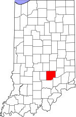
Bartholomew County, Indiana Basics:


Bartholomew County Indiana - Government Site

Population: 78,966
Area: 407 square miles
County seat: Columbus
Area code(s) in use: 812
Time zone: EST
High school graduate or higher: 89.1%
Bachelor's degree or higher: 26.6%
Median household income: $54,481
Persons in poverty: 11.8%
Home ownership rate: 72.2%
Mean travel time to work: 19.3 minutes


Adjacent counties:
Brown  Decatur  Jackson  Jennings  Johnson  Shelby  

Find in Indiana

Map of the Bartholomew County area


Our detail map of Bartholomew County shows the Bartholomew County, Indiana boundary lines and other interesting items.

Places in Bartholomew County, Indiana

  Airports     show all on map

Bartholomew County Hospital Airport, Columbus Municipal Airport, Himsel Army Airfield, Strietelmeier Flying Field Airport

  Bridges     show all on map

Tannehill Covered Bridge

  Buildings     show all on map

Clay Township Fire Department, Clifford Volunteer Fire Department, Columbus Fire Department Station 1, Columbus Fire Department Station 2, Columbus Fire Department Station 3, Columbus Fire Department Station 4, Columbus Fire Department Station 5, Columbus Fire Department Station 6, Columbus Regional Hospital Ambulance Service Station 1, Columbus Regional Hospital Ambulance Service Station 3, Columbus Regional Hospital Emergency Medical Service, East Columbus Independent Fire Department, East Columbus Independent Fire Department Station 221 Headquarters, East Columbus Independent Fire Department Station 222, Elizabethtown Fire and Rescue, German Township Fire Department, Harrison Township Volunteer Fire Department Station 25, Hartsville Volunteer Fire Department, Hope Volunteer Fire Department, Jonesville Fire Department Station 1, Jonesville Fire Department Station 2, Southwest Bartholomew County Volunteer Fire Company, Stat Ambulance Service

  Canals     show all on map

Armuth Ditch, Chambers Ditch

  Cemeteries     show all on map

Carter Cemeteries, Columbus City Cemetery, Daugherty Cemetery, Donaldson Cemetery, Flat Rock Cemetery, Fletcher Cemetery, Galbraith Cemetery, Garland Brook Cemetery, Haislup Cemetery, Hartsville College Cemetery, Kansas Cemetery, Lambert Cemetery, Lawton Cemetery, Liberty Cemetery, Little Sand Creek Cemetery, Moravian Cemetery, Mount Pleasant Cemetery, Mount Pleasant Cemetery, New Harmony Cemetery, Old Saint Louis Cemetery, Parkison Cemetery, Roth Cemetery, Saint Paul Cemetery, Sand Creek Cemetery, Sand Hill Cemetery, Sharon Cemetery, Sidener Cemetery, Sidney Branch Cemetery, Simmons Cemetery, Spaugh Cemetery, Springer Cemetery, Steenbarger Cemetery, Tannehill Cemetery, Thompson Cemetery, Treadway Cemetery

  Census     show all on map

Taylorsville Census Designated Place

  Churches     show all on map

Asbury Church, Berea Church, East Columbus Church, Enon Church, Friends Meetinghouse, Friendship Church, Grace Church, Haw Creek Church, Mount Carmel Church, Mount Healthy Church, Mount Olive Church, Mount Pleasant Church, New Hope Church, New Zion Church, Ogilville Church, Ohio Chapel, Old Bethel Church, Old Union Church, Saint Johns Church, Saint Johns Church, Saint Pauls Church, Saint Peters Church, Shiloh Church, Shiloh Church, Trinity Church, United Separate Church, Walker Chapel, Wesley Chapel, White Creek Church

  Crossings     show all on map

Interchange 76

  Dams     show all on map

Echo Lake Dam, Fred C Owen Lodge Lake Dam, Grandview Dam, Grouse Ridge Lake Dam, Harrison North Lake Dam, Harrison South Lake Dam, Indian Lake Dam, Jean Williamson Lake Dam, Lawsons Lake Dam, Meyer Lake Dam, Schaefer Lake Dam, Schultz Lake Dam, Staller Lake Dam, Suhre Lake Dam, Terrace Lake Dam, Thompson Lake Dam, Youth Camp Lake Dam

  Hospitals     show all on map

Columbus Behavioral Center for Children and Adolescents, Columbus Regional Hospital

  Lakes     show all on map

Long Lake, Twin Lakes, Wood Lake

  Locales     show all on map

25th Street Shopping Center, Corya Pork Farm, Eastbrook Plaza, Harrison Lake Country Club, Holiday Center Shopping Center, Shireman Hog Farm, West Hill Shopping Center

  Military     show all on map

Atterbury Army Air Field (historical), Camp Atterbury Joint Maneuver Training Center

  Mines     show all on map

Meshberger Quarry

  Parks     show all on map

Clifty Creek Park, Donner Park, Grouse Ridge Public Fishing Area, Lincoln Park

  Populated Places     show all on map

Azalia, Bethany, Bethel Village, Burnsville, Clifford, Columbus, Corn Brook, Cuba, East Columbus, Elizabethtown, Everroad Park, Flat Rock Park, Forest Park, Galader Station, Garden City, Grammer, Grandview Lake, Hartsville, Hope, Jewell Village, Jonesville, Kansas, Lowell, Mount Healthy, Newbern, North Columbus, North Gate, North Ogilville, North Park, Northcliff, Nortonburg, Ogilville, Old Saint Louis, Parkside, Petersville, Pleasant View Village, Riverview Acres, Rosstown, Rugby, Saint Louis Crossing, Stony Lonesome, Taylorsville, Twin Crest, Walesboro, Waymansville, Waynesville

  Post Offices     show all on map

Azalia Post Office

  Reservoirs     show all on map

Crystal Lake, Echo Lake, Everroad Lake, Fraternal Order Columbus Police Lake, Grandview Lake, Grouse Ridge Lake, Harrison Lake, Jean Williamson Lake, Lake Barbara, Lawsons Lake, Lutheran Lake, Noblitt Lake, North Harrison Lake, Schaefer Lake, Schultz Lake, South Harrison Lake, Staller Lake, Suhre Lake, Tamerix Lake, Terrace Lake, Thompson Lake, Thompsons Lake, Youth Camp Lake

  Schools     show all on map

Booth-Setser School, Central Junior High School, Clifty Creek Elementary School, Columbus North High School, Cross Cliff Elementary School, Garfield School, Hauser Junior-Senior High School, Hope Elementary School, Jefferson Elementary School, Kent Elementary School, Lillian Schmitt Elementary School, Lincoln Elementary School, McDowell School, McKinley School, Northside Elementary School, Ogilville School, Parkside Elementary School, Saint Bartholomews School, Saint Peter Lutheran School, State Street School, Taylorsville Elementary School, The International School of Columbus, White Creek Lutheran School

  Streams     show all on map

Brush Creek, Catherine Creek, Chicken Creek, Cooks Creek, Denios Creek, Fishers Fork, Flatrock River, Horse Creek, Lick Creek, Little Sand Creek, Mud Creek, Muddy Branch Creek, North Branch Wolf Creek, Opossum Creek, Otter Creek, Prince Creek, Saddle Creek, Sand Branch, Slash-Loesch Ditch, Sloan Branch, South Fork White Creek, Trimnell Branch, Wolf Creek

  Summits     show all on map

Dowell Hill, Dug Hill, Gilmore Hill, Guffy Hill, Patterson Hill, Taylor Hill, Wrights Hill

  Towers     show all on map

WCSI-AM (Columbus), WCSI-FM (Colombus), WWWY-FM (Columbus),

Bartholomew County, Indiana Population By Race (2012 estimate)

RacePopulation
WhiteBartholomew County White population 72,09672,095  
AsianBartholomew County Asian population 3,5533,553
BlackBartholomew County Black population 1,6581,658
MixedBartholomew County Mixed population 1,1841,184
American IndianBartholomew County American Indian population 395394
Hawaiian & Pacific IslanderBartholomew County Hawaiian & Pacific Islander population 7978

Additional population tables :
State population table
Indiana population by county