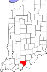
Crawford County, Indiana Basics:


Crawford County Indiana - Government Site

Population: 10,647
Area: 306 square miles
County seat: English
Area code(s) in use: 812
Time zone: EST
High school graduate or higher: 81.1%
Bachelor's degree or higher: 12.5%
Median household income: $40,027
Persons in poverty: 19.6%
Home ownership rate: 82.7%
Mean travel time to work: 32.6 minutes


Adjacent counties:
Dubois  Harrison  Meade (KY)  Orange  Perry  Washington  

Find in Indiana

Map of the Crawford County area


Our detail map of Crawford County shows the Crawford County, Indiana boundary lines and other interesting items.

Places in Crawford County, Indiana

  Airports     show all on map

Roberson Airport

  Arches     show all on map

Arrowhead Arch, Ravine Arch

  Bends     show all on map

Oxbow Bend

  Buildings     show all on map

Crawford County Ambulance Service, English Volunteer Fire Department, English Volunteer Fire Department Patoka Station, English Volunteer Fire Department Union Station, Leavenworth Fire Department Station 2, Leavenworth Volunteer Fire Department, Marengo Liberty Township Volunteer Fire Department, Milltown Volunteer Fire Department

  Cemeteries     show all on map

Birds Cemetery, Blunk Cemetery, Brown Cemetery, Cunningham Cemetery, Davis Cemetery, Denbo Cemetery, Doan Cemetery, Eckerty Cemetery, Everton Cemetery, Fessler Cemetery, Flower Point Cemetery, Gilmore Cemetery, Goad Cemetery, Grant Cemetery, Hamilton Cemetery, Hedden Cemetery, Keysacker Cemetery, Land Cemetery, Leavenworth Memorial Garden, Marengo Cemetery, Marengo Cemetery New Section, Marengo Cemetery Old Section, Mount Eden Cemetery, Old Leavenworth Cemetery, Old Union Cemetery, Orchard Hill Cemetery, Parker Moore Cemetery, Pleasant Green Cemetery, Potter Cemetery, Purkhiser Cemetery, Riddle Cemetery, Saint Josephs Cemetery, Seton Cemetery, Sheckell Cemetery, Sloan Cemetery, Stewart Cemetery, Totten Cemetery, White Cemetery, Williams Cemetery, Wiseman Cemetery

  Churches     show all on map

Bethany Church, Bogard Church, Crawford Church, Dillman Church, Dry Run Church, Fairview Church, Goodman Ridge Church, Harvey Flat Church, Highfill Chapel, Liberty View Church, Mathers Chapel, Mount Lebanon Church, Mount Sterling Church, Mount Zion Church, Old Union Church, Pilot Knob Church, Pleasant Ridge Church, Pleasant Ridge Church, Rock Springs Church, Saint Josephs Church, Shafer Ridge Church, Simpson Chapel, Union Chapel, Union Church, Wyandotte Church

  Cliffs     show all on map

Hemlock Cliffs

  Dams     show all on map

Wyandotte Lake Dam

  Gaps     show all on map

The Narrows

  Islands     show all on map

Self Island

  Lakes     show all on map

Bluegill Pond, Grant Lake, Spring Lake

  Locales     show all on map

Hemlock Cliffs Recreation Area

  Mines     show all on map

Cape Sandy Quarry Number 1, Cape Sandy Quarry Number 2, Eckerty Quarry, Temple Quarry

  Oilfields     show all on map

Dexter Well (historical)

  Parks     show all on map

Hilands Overlook State Park, Sulphur Lake Picinic Area

  Populated Places     show all on map

Alton, Artist Point, Beechwood, Brownstown, Cape Sandy, Carefree, Curby, Deuchars, Eckerty, English, Fredonia, Grantsburg, Hogtown, Jericho, Leavenworth, Magnolia, Marengo, Mifflin, Milltown, Pilot Knob, Riceville, Riddle, Schooler Point Landing, Sulphur, Sulphur Springs, Switzer Crossroads, Taswell, Temple, West Fork, Wickliffe, Wyandotte

  Post Offices     show all on map

Eckerty Post Office, Grantsburg Post Office, Padora Post Office (historical)

  Reservoirs     show all on map

English Reservoir, English Water Supply Dam, Patoka Lake, Timberlin Lake, Whispering Pines Pond, Wyandotte Lake

  Ridges     show all on map

Doan Ridge, Indian Ridge, McKensie Ridge, Shafer Ridge, Tick Ridge, White Oak Ridge

  Schools     show all on map

Allstott School, Allstott School, English School, Jericho School, Johnson Township School, Leavenworth School, Milltown School, Patoka School, Pedora School, Pedora School, Township School

  Springs     show all on map

Union Tar Spring (historical)

  Streams     show all on map

Allen Creek, Bailey Creek, Bird Hollow Creek, Bogard Creek, Brandywine Fork, Brownstown Creek, Brushy Creek, Camp Fork Creek, Dog Creek, Dry Run, Highfill Creek, Huffman Branch, Jaby Creek, Jordan Creek, Little Patoka River, Low Gap Branch, Mitchell Creek, Otter Creek, Reasor Branch, Russell Branch, Sharpe Creek, Slick Run, Sycamore Creek, Texas Creek, Turkey Fork, Whiskey Run

  Summits     show all on map

Benz Hill, Pilot Knob, Scott Hill, Seton Knob, Tunnel Hill

  Towers     show all on map

Spears Lookout Tower, West Fork Lookout Tower, WSWI-AM (Evansville)

  Valleys     show all on map

Bird Hollow, Devils Hollow, Golden Hollow, Houghland Hollow, Indian Hollow, Pophins Hollow, Smith Hollow,

Crawford County, Indiana Population By Race (2012 estimate)

RacePopulation
WhiteCrawford County White population 10,41310,412  
MixedCrawford County Mixed population 106106
American IndianCrawford County American Indian population 4342
AsianCrawford County Asian population 2121
Hawaiian & Pacific IslanderCrawford County Hawaiian & Pacific Islander population 1110

Additional population tables :
State population table
Indiana population by county