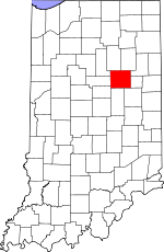
Grant County, Indiana Basics:


Grant County Indiana - Government Site

Population: 69,344
Area: 414 square miles
County seat: Marion
Area code(s) in use: 765
Time zone: EST
High school graduate or higher: 84.6%
Bachelor's degree or higher: 17.2%
Median household income: $39,751
Persons in poverty: 17.5%
Home ownership rate: 69.6%
Mean travel time to work: 19.0 minutes


Adjacent counties:
Blackford  Delaware  Howard  Huntington  Madison  Miami  Tipton  Wabash  Wells  

Find in Indiana

Map of the Grant County area


Our detail map of Grant County shows the Grant County, Indiana boundary lines and other interesting items.

Places in Grant County, Indiana

  Airports     show all on map

Dupouy Airport, Fox Station Airport, Marion Municipal Airport, Peacock Farms Airport

  Buildings     show all on map

Able Ambulance, Center Township Volunteer Fire Department, Emily Flynn Home, Fairmount Fire Department, Gas City Volunteer Fire Department, Grant County Emergency Medical Services - Fairmount Medic 7, Grant County Emergency Medical Services - Gas City Medic 9 and 12, Grant County Emergency Medical Services - Matthews Medic 10, Grant County Emergency Medical Services - Van Buren Medic 6, Grant County Emergency Medical Services Headquarters, Grant County Emergency Medical Services Washington Medic 11, Green Township Volunteer Fire Department, Jonesboro Volunteer Fire Department, Marion Fire Department Station 1, Marion Fire Department Station 2, Marion Fire Department Station 4, Marion Fire Department Station 5, Marion Fire Department Station 6, Matthews Volunteer Fire Department, Mill Township Volunteer Fire Department, Miller Purdue Agricultural Center, Pleasant Township Volunteer Fire Department, Quality Care Ambulance, Southwest Medic Ambulance, Swayzee Fire Department, TransCare Ambulance Service, Upland Volunteer Fire Department, Van Buren Volunteer Fire Department, Washington Township Volunteer Fire Department Marion

  Canals     show all on map

Baker Ditch, Brown Ditch, Buck Run Ditch, Doyle Ditch, Dry Fork Ditch, Dry Fork Ditch, Enoch Lee Ditch, Farley Ditch, Ferguson Ditch, Fowler Ditch, Galatia Ditch, Goff Ditch, Hailies Prairie Ditch, Hanes Ditch, Hodson Ditch, Hollis Ditch, Hyer Ditch, Jefferson Ditch, Johnson Ditch, Keaton Ditch, Leisure Ditch, Little Crane Pond Ditch, Little Newby Ditch, Lloyd Ditch, Lomax Ditch, Ludlum Ditch, Maddox Ditch, Mathews Ditch, Monroe Ditch, Moriarity Ditch, Necessity Ditch, Pattison Ditch, Pulley Ditch, Rich Ditch, Sims-Franklin Ditch, Smith Ditch, Steelman Ditch, Stuckey Ditch, Sweetser Ditch, Sweetser Improvement Ditch, Tappin Ditch, Thompson Ditch, Tinkle Ditch, Tippey Ditch, Unthank Ditch, Waters Ditch, Wimmer Ditch, Winslow Ditch, Woods Ditch, Zirkle Ditch

  Cemeteries     show all on map

Alel Cemetery, Atkinson Cemetery, Bethel Cemetery, Burson Cemetery, Cory Cemetery, Doyle Cemetery, Fairview Cemetery, Farrville Cemetery, Grant Memorial Park, Hummel-Lobdell Cemetery, Independent Order of Odd Fellows Cemetery, Independent Order of Odd Fellows Cemetery, Landess Cemetery, Lee Cemetery, Maple Grove Cemetery, Marion National Cemetery, Masonic Cemetery, Meshingomesia Cemetery, Park Cemetery, Riverside Cemetery, Rowland Cemetery, Salem Cemetery, Shiloh Cemetery, Thraikill Cemetery, Walnut Creek Cemetery

  Census     show all on map

Herbst Census Designated Place, Jalapa Census Designated Place, Landess Census Designated Place, Mier Census Designated Place, Point Isabel Census Designated Place, Sims Census Designated Place

  Churches     show all on map

Antioch Church, Antioch Church, Back Creek Church, Back Creek Church, Bethel Church, Calvary Temple, Center Chapel, Center Church, Covenant Presbyterian Church, Fletcher Church, Griffin Church, Harmony Church, Hill Chapel, Jefferson Church, Jones Chapel, Knox Chapel, Liberty Chapel, Little Ridge Church, Locust Chapel, Lugar Creek Church, Lugar Creek Church, Maple Run Church, Morris Chapel, Mount Olive Church, Northwestern Church, Oak Chapel, Oak Ridge Church, Radley Church, Richland Chapel, Union Chapel, Union Chapel, Upland Community Church

  Dams     show all on map

Brookhaven Addition Lake Dam, Glendale Lake Dam, Lincoln Country Club Lake Dam, Loew Lake Dam South, Sports Lake Dam, Taylor Lake Dam

  Hospitals     show all on map

Cornerstone Behavioral Health Center, Marion General Hospital, Veterans Affairs Northern Indiana Health Care System Marion Campus

  Lakes     show all on map

Crane Pond, Dollar Lake, Lake Marion

  Locales     show all on map

Marion Plaza, Meshingomesta Country Club, North Park Plaza Shopping Center, Northgate Shopping Center, Panorama Shopping Center, Purdue University Memorial Farm, Shady Lawn Hog Farm

  Parks     show all on map

Barnes Park, Bell Park, Clear Water Park, Franklin Park, Home Park, Lincoln Park, Matter Park, Riverside Park, Seventh Michigan Park, Sunnyacres Park, Webster Park, Westlea Park

  Populated Places     show all on map

Arcana, Bethevan, Brookhaven, Cole, Dooville, Doyle Ferguson, Fairmount, Farrville, Fowlerton, Fox, Friendly Corner, Gas City, Hackleman, Hanfield, Herbst, Home Corner, Jadden, Jalapa, Jonesboro, Kiley, Lake Wood, Landess, Marion, Matthews, Michaelsville, Mier, Normal, Point Isabel, Radley, Rigdon, Roseburg, Shadeland, Shady Hills, Sims, Swayzee, Sweetser, Upland, Van Buren, Weaver, Westwood Square

  Reservoirs     show all on map

Brookhaven Addition Lake, Glendale Lake, Lincoln Country Club Lake, Loew Lake, Sports Lake, Taylor Lake, Wagner Lake

  Schools     show all on map

Allen Elementary School, Bennett School, Center Elementary School, Clayton Brownlee Elementary School, East Elementary School, Emerson School, Evans School, Fairmount Middle School, Frances Slocum Elementary School, Franklin School, Grant School, Highland School, Indiana Wesleyan University, J C Knight Elementary School, John L McCulloch Junior High School, John W Kendall Elementary School, Lincoln Elementary School, Mann School, Marion High School, Martin Boots Elementary School, Matthews Elementary School, Mississinewa High School, Oak Hill High School, Park Elementary School, R J Baskett Middle School, Riverview Elementary School, Roosevelt School, Saint Paul School, Swayzee Elementary School, Sweetser Elementary School, Taylor University, Thomas Jefferson Elementary School, Upland Elementary and Middle School, Van Buren Elementary and Middle School, Washington Elementary School, Washington Elementary School, Westview Elementary School

  Streams     show all on map

Ball Run, Barren Creek, Bean Run, Bell Creek, Big Lick Creek, Boots Creek, Branch Creek, Brushy Run, Cane Run, City Run, Club Run, Crawford Creek, Deer Creek, Ethel Run, Fowlerton Drain, Hummel Creek, Jocinah Creek, Lake Branch, Little Black Creek, Little Creek, Little Deer Creek, Little Walnut Creek, Long Branch, Lugar Creek, Massey Creek, Mat Run, Monroe Prairie Creek, New Prairie Creek, Octain Creek, Regular Run, Roods Run, Round Run, Shell Run, Sports Run, Stoney Creek, Taylor Creek, Upland Drain, Van Run, Walnut Creek

  Swamps     show all on map

Cypress Swamps

  Towers     show all on map

WBAT-AM (Marion), WGOM-AM (Marion), WMRI-FM (Marion),

Grant County, Indiana Population By Race (2012 estimate)

RacePopulation
WhiteGrant County White population 62,06362,062  
BlackGrant County Black population 4,9234,923
MixedGrant County Mixed population 1,5261,525
AsianGrant County Asian population 485485
American IndianGrant County American Indian population 277277
Hawaiian & Pacific IslanderGrant County Hawaiian & Pacific Islander population 00

Additional population tables :
State population table
Indiana population by county