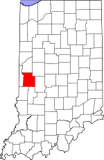
Parke County, Indiana Basics:


Parke County Indiana - Government Site

Population: 17,107
Area: 445 square miles
County seat: Rockville
Area code(s) in use: 765
Time zone: EST
High school graduate or higher: 82.0%
Bachelor's degree or higher: 14.3%
Median household income: $45,489
Persons in poverty: 14.9%
Home ownership rate: 84.7%
Mean travel time to work: 24.9 minutes


Adjacent counties:
Clay  Fountain  Montgomery  Putnam  Vermillion  Vigo  

Find in Indiana

Map of the Parke County area


Our detail map of Parke County shows the Parke County, Indiana boundary lines and other interesting items.

Places in Parke County, Indiana

  Airports     show all on map

Butler Field Airport, Heaton Private Airport, Reinoehl Field Airport

  Bends     show all on map

Hethcoe Bottoms, Russell Bend

  Bridges     show all on map

Adams Covered Bridge (historical), Beeson Covered Bridge, Billie Creek Bridge, Bowsher Ford Bridge, Bridgeton Bridge, Catlin Bridge, Coal Creek Covered Bridge, Conleys Ford Covered Bridge, Cox Ford Covered Bridge, Crooks Covered Bridge, Grange Corner Covered Bridge (historical), Harry Evans Covered Bridge, Jackson Bridge, Jeffries Ford Bridge, Jessup Covered Bridge, Leatherwood Station Bridge, Mansfield Bridge, Marshall Covered Bridge, McAllisters Covered Bridge, Mecca Bridge, Melcher Bridge, Mill Creek Bridge, Narrows Bridge, Neet Covered Bridge, Nevins Covered Bridge, Phillips Bridge, Portland Mills Bridge, Red Covered Bridge (historical), Rocky Fork Covered Bridge, Roseville Covered Bridge, Rush Creek Bridge, Sim Smith Bridge, State Sanatorium Bridge, Thorpe Ford Covered Bridge, West Union Bridge, Wilkins Mill Covered Bridge, Zacke Cox Bridge

  Buildings     show all on map

Bellmore Fire Department, Bellmore Volunteer Fire Department, Bloomingdale Fire Department, Bridgeton Fire Department, Bridgeton Volunteer Fire Department, Lyford Volunteer Fire Department, Marshall Volunteer Fire Department, Mecca - Wabash Township Volunteer Fire Department, Montezuma Reserve Township Volunteer Fire Department, Parke County Emergency Medical Services and Transport Service, Rockville Fire Department, Rockville Fire Department / Parke County Rescue Squad, Rosedale Volunteer Fire Department

  Canals     show all on map

Lyford Dike and Levee Association Ditch

  Cemeteries     show all on map

Adams Cemetery, Arabia Cemetery, Armiesburg Cemetery, Barnes Cemetery, Bethany Cemetery, Blake Cemetery, Bloomingdale Cemetery, Bound Cemetery, Bristleridge Cemetery, Brockway Cemetery, Bruin Cemetery, Brunot Cemetery, Buchanan Cemetery, Burton Cemetery, Cashatt Cemetery, Causey Cemetery, Clear Run Cemetery, Clodfelter Cemetery, Coffin Cemetery, DeBaun Cemetery, Denman Cemetery, Elder Cemetery, Ephlin Cemetery, Hartmans Cemetery, Harvey Cemetery, Hatfield Cemetery, Hethcoe Cemetery, Hixon Cemetery, Jacks Cemetery, Jarvis Cemetery, Lane Cemetery, Lough Cemetery, Martin Cemetery, Memory Garden Cemetery, Moore Cemetery, Mount Moriah Cemetery, Mount Pleasant Cemetery, Oakland Cemetery, Orlea Cemetery, Overman Cemetery, Philadelphia Cemetery, Poplar Cemetery, Raccoon Cemetery, Rawlings Cemetery, Roach Cemetery, Rowe Cemetery, Rukes Cemetery, Rush Creek Cemetery, Russell Cemetery, Seybold Cemetery, Shirk Cemetery, Spencer Cemetery, Thomas Cemetery, Union Cemetery, Warner Cemetery, Watts Cemetery, Webster Cemetery

  Churches     show all on map

Daily Chapel, Fairview Church, Friendly Grove Church, Friends Church, Friends Union Church, Liberty Church, Linebarger Chapel, Lusk Chapel, Mount Hermon Church, Mount Olivet Church, New Bethel Church, New Discovery Church, North Union Church, Otterbein Church, Parkville Church, Pleasant Valley Church, Portland Mills Church, Rush Creek Church, Saint Marys Church, Sand Creek Church, Waterman Church, Wolf Creek Church, Zion Chapel

  Dams     show all on map

Aitken Lake Dam, Cecil M Harden Lake Dam, Lakeview Estates Lake Dam, Little Raccoon Structure Number 11, Little Raccoon Structure Number 15, Little Raccoon Structure Number 16, Little Raccoon Structure Number 2-C, Little Raccoon Structure Number 3, Rocky Fork Lake Dam, Stockton Lake Dam, Terre Haute Boys Club Lake Dam

  Falls     show all on map

Groundhog Falls

  Gaps     show all on map

Narrows

  Lakes     show all on map

Alma Lake, Zellors Pond

  Locales     show all on map

Cornstalk (historical), Dooley Station (historical), Lakeland (historical), Mansfield Ramp, Needmore (historical), Parke County Golf Course, Raccoon Ramp, Russellville, Sand Creek Station, Walker Ramp

  Military     show all on map

Rockville Air Force Station (historical)

  Parks     show all on map

Camp Gulick, Camp Weeapahko, Four-H Club Fairgrounds, Jungle Park, Raccoon Lake State Recreation Area, Turkey Run State Park

  Pillars     show all on map

Pedestal Rock

  Populated Places     show all on map

Alma Lake, Annapolis, Arabia, Armiesburg, Banner Mills, Bellmore, Bethany, Billie Creek Village, Bloomingdale, Bradfield Corner, Bridgeton, Byron, Catlin, Cincinnati, Coke Oven Hollow, Coloma, Coxville, Diamond, Ferndale, Grange Corner, Guion, Hollandsburg, Howard, Hudnut, Jessup, Judson, Klondyke, Leatherwood, Lena, Lodi, Lusks Mills (historical), Lyford, Madalline, Mansfield, Marshall, Mecca, Melcher (historical), Midway, Milligan, Minshall, Montezuma, New Discovery, Numa, Nyesville, Parkeville, Piattsville, Pin Hook, Pottertown (historical), Rockport, Rockville, Rosedale, Smockville, Snow Hill, Stumptown, Superior, Sylvania, Tangier, Walton (historical), West Atherton, West Melcher, West Union

  Post Offices     show all on map

Annapolis Post Office (historical), Russellville Post Office (historical)

  Reservoirs     show all on map

Case Lake, Cecil M Harden Lake, Lakeview Estates Lake, Rocky Fork Lake, Terre Haute Boys Club Lake

  Schools     show all on map

Bridgeton Elementary and Junior High School, Mecca Elementary School, Montezuma Elementary School, Montezuma Junior High and Senior High School, Rockville Elementary School, Rockville Junior-Senior High School, Rockville Training Center, Rosedale Elementary and High School, Turkey Run Elementary School, Turkey Run High School

  Slopes     show all on map

Devils Den

  Springs     show all on map

Lusks Springs (historical)

  Streams     show all on map

Alma Creek, Bains Branch, Big Branch, Bill Diddle Creek, Black Run, Calcutta Run, Carbon Stream, Cat Creek, Clear Run, Coal Creek, Cumberland Creek, Diamond Creek, East Fork Rush Creek, East Prong Green Creek, Ebenezer Creek, Ford Run, Gold Run, Green Creek, Groundhog Branch, Hopper Branch, Indian Branch, Jack Brook, Jeffries Run, Jim Branch, Keller Branch, Lakeys Branch, Leatherwood Branch, Leatherwood Creek, Lena Drain, Limestone Branch, Little Leatherwood Creek, Little Raccoon Creek, Little Rocky Fork Creek, Maxwell Branch, Maxwell Branch, Middle Prong Green Creek, Molasses Creek, Montgomery Branch, No Brook, Panther Creek, Rass Clore Branch, Rays Branch, Readys Creek, Roaring Creek, Rock Run, Rocky Fork Creek, Rocky Run, Rush Creek, Sand Creek, Scrouge Branch, Springdale Run, Straight Branch, Strange Branch, Sugar Creek, Sugar Mill Creek, Sulphur Branch, Sunderland Branch, Sutherlin Branch, Troutman Branch, Turkey Run, Wapalo Creek, Weisner Creek, Welchel Branch, West Fork Rush Creek, West Prong Green Creek, Williams Creek

  Towers     show all on map

WAXI-FM (Rockville), WRFT-FM (Indianapolis)

  Valleys     show all on map

Happy Hollow, Pleasant Valley, Pot Rock Hollow, Rocky Hollow,

Parke County, Indiana Population By Race (2012 estimate)

RacePopulation
WhiteParke County White population 16,47416,474  
BlackParke County Black population 411410
MixedParke County Mixed population 103102
American IndianParke County American Indian population 6868
AsianParke County Asian population 3434
Hawaiian & Pacific IslanderParke County Hawaiian & Pacific Islander population 00

Additional population tables :
State population table
Indiana population by county