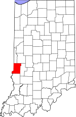
Vigo County, Indiana Basics:


Vigo County Indiana - Government Site

Population: 108,534
Area: 403 square miles
County seat: Terre Haute
Area code(s) in use: 812 317
Time zone: EST
High school graduate or higher: 86.2%
Bachelor's degree or higher: 21.4%
Median household income: $40,547
Persons in poverty: 19.0%
Home ownership rate: 65.2%
Mean travel time to work: 20.2 minutes


Adjacent counties:
Clark (IL)  Clay  Edgar (IL)  Parke  Sullivan  Vermillion  

Find in Indiana

Map of the Vigo County area


Our detail map of Vigo County shows the Vigo County, Indiana boundary lines and other interesting items.

Places in Vigo County, Indiana

  Airports     show all on map

Aero Plaines Airport, Ellis Fly-In Airport, Higginbotham Field, Kester Fly Inn Airport, Shure Airport, Sky King Airport, Terre Haute International Airport-Hulman Field

  Bends     show all on map

Aurora Bend

  Buildings     show all on map

Alcan Aluminum Fire Brigade, Bunch Nurseries, Fayette Township Volunteer Fire Department of Sanford, Honey Creek Department of Fire and Rescue Station 1 Headquarters, Honey Creek Department of Fire and Rescue Station 2, Honey Creek Department of Fire and Rescue Station 3, Honey Creek Department of Fire and Rescue Station 4, Linton Township Volunteer Fire Protection Company, Nevins Township Volunteer Fire Department, New Goshen Fire and Rescue, Otter Creek Township Fire Department Station 1 North Terre Haute Headquarters, Otter Creek Township Fire Department Station 2 Sandcut, Otter Creek Township Fire Department Station 3 Burnett, Pierson Volunteer Fire Department, Prairie Creek Township Fire Department, Prairieton Fire Department, Riley Volunteer Fire Department, Seelyville Volunteer Fire Department, Shepardsville Volunteer Fire Department, Sugar Creek Fire Department Station 41 Headquarters, Sugar Creek Fire Department Station 42, Terre Haute Fire Department Station 11, Terre Haute Fire Department Station 2, Terre Haute Fire Department Station 3, Terre Haute Fire Department Station 5, Terre Haute Fire Department Station 6, Terre Haute Fire Department Station 7, Terre Haute Fire Department Station 8, Terre Haute Fire Department Station 9, Terre Haute International Airport - Hulman Field Fire Station, Torner House, TransCare Ambulance Service

  Canals     show all on map

Cox Number One Ditch, Cox Number Two Ditch, Gundy Ditch, McFarland Ditch, Negro Ditch, Swope Ditch, Thompson Ditch

  Cemeteries     show all on map

Armstrong Cemetery, Barbour Cemetery, Brown Cemetery, Calvary Cemetery, Chamberlain Cemetery, Coltrin Cemetery, Cooper Cemetery, Cress Cemetery, Denny Cemetery, Donham Cemetery, Durham Cemetery, Evans Cemetery, Grandview Cemetery, Harpold Cemetery, Haven Cemetery, Highland Lawn Cemetery, Hobmeyer Cemetery, Hull Cemetery, Hyde Cemetery, Jones Cemetery, Kennedy Cemetery, Kester Cemetery, Liberty Cemetery, Lykens Cemetery, Markles Cemetery, Mewhinney Cemetery, Mewhinney Cemetery, Miner Cemetery, Moses Cemetery, New Harmony Cemetery, Phillips Cemetery, Pleasantview Cemetery, Richer Cemetery, Roberts Cemetery, Rogers Cemetery, Roselawn Memorial Park, Ruggles Cemetery, Shattuck Cemetery, Sheets Cemetery, Smith Cemetery, Stephens Cemetery, Steveson Cemetery, Stewart Cemetery, Sullian Cemetery, Swalls Cemetery, Taylor Cemetery, Union Cemetery, Watson Cemetery, West Prairie Creek Cemetery, Wood Cemetery, Woodlawn Cemetery

  Census     show all on map

Dresser Census Designated Place, Fontanet Census Designated Place, New Goshen Census Designated Place, North Terre Haute Census Designated Place, Saint Mary of the Woods Census Designated Place, Shepardsville Census Designated Place, Tecumseh Census Designated Place, Toad Hop Census Designated Place

  Churches     show all on map

Bethesda Church, Calvary Church, Center Hill Church, Christus Victor Church, Farmers Chapel, Fletcher Chapel, Friendship Church, Lost Creek Church, Lost Creek Church, Mount Aetna Church, Mount Olive Church, New Vermillion Church, Oak Hill Church, Oregon Church, Otter Creek Church, Pleasant Valley Church, Prairie Creek Church, Shady Grove Church, Sulphur Spring Church, Trinity Church, Union Church, Union Church

  Dams     show all on map

Boyll Lake Dam, Busseron Dam Number G-10, Busseron Dam Number G-4, Farmers Lake Dam East, Felstein Lake Dam, Forest Park Swimming Pool Dam, Fowler Park Dam, Green Valley Mine Pond Dam, Highway Dam, Hulman Lodge Dam, Hulman Street Dam, Kieweg Lake Dam, Lakewood Subdivision Dam, Lost Creek Conservation Club Lake Dam, Maple Avenue Lake Dam, Morey Lake Dam, Move Over Lake Dam, Paint Mill Lake Dam, Patton Lake Dam, Prairie Dam Number 2, Saint Mary of the Woods Lake Dam, Tri-Land Estates Lake Dam, Wadsworth Lake Dam, Wanda Lake Dam, Windmere Lake Dam

  Hospitals     show all on map

Hamilton Center, Terre Haute Regional Hospital, Union Hospital

  Lakes     show all on map

Blue Hole, Blue Hole, Chestnut Bayou, French Lake, Goose Pond (historical), Grant Mine Pond, Green Valley Mine Pond, Greenfield Bayou, Hickory Grove Pond, Izaak Walton Lake, Lee Lake, Little Grassy Pond, Malone Pond, Moore Pond (historical), Muskrat Pond, North Lake, Round Pond, South Lake, Wonder Lake

  Locales     show all on map

Darwin Ferry, Dresser Power Plant, Elsworth Station, Fort Harrison Country Club, Honey Creek Square Shopping Center, Milton Station, Phoenix Country Club, Rea Park Golf Course, Richardson Hog Farm, Riley Conservation Club, Sycamore Ridge Landfill, Terre Haute Federal Penitentiary, Terre Haute Saddle Club

  Military     show all on map

Fort Harrison (historical)

  Mines     show all on map

Mount Pleasant Mine

  Parks     show all on map

Camp Illana, Camp Maumee, Collett Park, Dresser Memorial Park, Fairbanks Park, Green Valley Public Fishing Area, Lost Creek Community Grove, Memorial Park, Sheridan Park, Spencer Park, Sycamore Park, Vorrhees Park, Wildwood Camp

  Populated Places     show all on map

Allendale, Atherton, Barnhart Town, Blackhawk, Brown Jug Corner, Burnett, Cherryvale, Coal Bluff, Cobb, Deming Park, Deming Woods, Dewey, Duane Yards, East Glenn, Ehrmandale, Ferguson Hill, Fontanet, Glen Ayre, Glenn Ayr, Gospel Grove, Grange Corner, Harrison, Hickory Island, Hutton, Keller, Larimer Hill, Lewis, Libertyville, Liggett, Marion Heights, Markles, New Goshen, North Terre Haute, Otter Creek Junction, Parkview, Pimento, Pine Ridge, Prairie Creek, Prairieton, Preston, Riley, Saint Mary-of-the-Woods, Sandcut, Sandford, Seelyville, Shepardsville, Shirkieville, Southwood, Spelterville, Spring Hill, State Line, Swalls, Tabertown, Taylorville, Tecumseh, Terre Haute, Terre Town, Toad Hop, Twelve Points, Vigo, West New Goshen, West Terre Haute, Whitcomb Heights, Woodgate, Youngstown

  Post Offices     show all on map

Nelson Post Office (historical), Pimento Post Office

  Reservoirs     show all on map

Boyle Lake, Crystal Lake, Farmer Lake, Forest Park Swimming Pool, Fowler Park Lake, Hulman Lodge Lake, Hulman Street Reservoir, Israel Lake, Kieweg Lake, Lake Noji, Lakewood Subdivision Lake, Llewellyn Lake, Lost Creek Conservation Club Lake, Maple Avenue Lake, Morey Lake, Paint Mill Lake, Patton Lake, Pennington Pond, Pine Ridge Mine Pond, Saint Marys Lake, Spring Lake, Strip Lake, Thompson Lake, Tri-Land Estates Lake, Wadsworth Lake, Wanda Lake, Windemere Lake

  Schools     show all on map

Blanche E Fuqua Elementary School, Cocannon School, Collett School, Crawford School, Cruft School, Davis Park Elementary School, Deming Elementary School, Fairbanks Elementary School, Garfield High School, Gerstmeyer High School, Gilbault School, Greenwood Elementary School, Honey Creek Junior High School, Indiana State University, Lange School, Lincoln School, Lost Creek Elementary School, Maple Avenue School, Maryland School, McKeen School, McLean Junior High School, Meadows Elementary School, Montrose School (historical), Otter Creek Junior High School, Rankin School, Rea School, Riley Elementary School, Rose Polytechnic Institute, Sacred Heart School, Saint Anns School, Saint Benedicts School, Saint Margaret Marys School, Saint Mary-of-the-Woods College, Saint Patrick School, Sandison School, Sarah Scott Junior High School, Schulte School, State High School, Sugar Creek School, Sugar Grove Elementary School, Terre Town Elementary School, Thompson School, Thornton School, Warren Elementary School, Washington School, Wiley High School, Woodrow Wilson Junior High School

  Streams     show all on map

Blue Brook, Brouilletts Creek, Brush Creek, Busseron Creek, Chowning Creek, Clago Creek, Clear Creek, Coal Creek, Crooked Creek, Crooked Creek, Dive Branch, East Little Sugar Creek, Flo Run, Green Brook, Harpold Run, Hawks Creek, Hayworth Slough, Honey Creek, Hooker Creek, Kokomo Creek, Little Creek, Little Honey Creek, Little Lost Creek, Little Sugar Creek, Lost Creek, Lost Creek, No End Creek, North Branch Otter Creek, North Coal Creek, North Salt Creek, Otter Creek, Owl Creek, Oxendine Bayou, Pit Run, Rio Grande Stream, Sharon Brook, Snake Creek, South Salt Creek, Splunge Creek, Spring Creek, Stone Quarry Branch, Sugar Creek, Sulphur Creek, Swim Brook, Turman Creek, Waterworks Creek, Watkins Creek, Web Run, Webster Creek, West Fork Busseron Creek, West Fork Turman Creek, West Little Sugar Creek, Wolf Creek

  Summits     show all on map

Big Knoll, Pottsville Hill, Sanford Hill, Trimmer Hill, Yaw Hill

  Towers     show all on map

WBOW-AM (Terre Haute), WISU-FM (Terre Haute), WISU-TV (Terre Haute), WMHD-FM (Terre Haute), WPFR-FM (Terra Haute), WTHI-FM (Terre Haute), WVTS-FM (Terre Haute), WWVR-FM (West Terre Haute), WZZQ-FM (Terra Haute),

Vigo County, Indiana Population By Race (2012 estimate)

RacePopulation
WhiteVigo County White population 96,05396,052  
BlackVigo County Black population 7,7067,705
MixedVigo County Mixed population 2,3882,387
AsianVigo County Asian population 1,9541,953
American IndianVigo County American Indian population 434434
Hawaiian & Pacific IslanderVigo County Hawaiian & Pacific Islander population 00

Additional population tables :
State population table
Indiana population by county