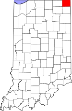
Steuben County, Indiana Basics:


Steuben County Indiana - Government Site

Population: 34,180
Area: 309 square miles
County seat: Angola
Area code(s) in use: 260
Time zone: EST
High school graduate or higher: 89.1%
Bachelor's degree or higher: 19.7%
Median household income: $48,291
Persons in poverty: 10.0%
Home ownership rate: 79.0%
Mean travel time to work: 21.7 minutes


Adjacent counties:
Branch (MI)  De Kalb  Hillsdale (MI)  Lagrange  Noble  Williams (OH)  

Find in Indiana

Map of the Steuben County area


Our detail map of Steuben County shows the Steuben County, Indiana boundary lines and other interesting items.

Places in Steuben County, Indiana

  Airports     show all on map

Pigeon Airport, Tri-State Steuben County Airport

  Bays     show all on map

Muskrat Bay

  Bridges     show all on map

Anspaugh Bridge, Enfield Bridge, Shaffer Bridge, Shaffer Bridge, Stallman Bridge

  Buildings     show all on map

Angola Fire Department, Fremont Volunteer Fire Department, Hamilton Volunteer Fire Department, Helmer Volunteer Fire Department, Hudson Fire Department, Metz Volunteer Fire Department, National Guard Armory, Orland Volunteer Fire Department and Rescue, Pleasant Lake Volunteer Fire Department, Salem Center Volunteer Fire Department, Steuben County Emergency Medical Services - Central Station, Steuben County Emergency Medical Services - North Station, Steuben County Rest Home

  Canals     show all on map

Baker Ditch, Bell Lake Ditch, Berlien Ditch, Burch Ditch, Cole Ditch, Conrad Ditch, Davis Ditch, Donald Kunkle Ditch, Eatinger Ditch, Goodale Ditch, Haughey Ditch, Jack Ditch, Johnson Ditch, Johnson Ditch, Lillian Metz Ditch, Metz Ditch, Ryan Ditch, Smathers Ditch, Stump Ditch

  Capes     show all on map

Browns Point, Hells Point, Lone Tree Point, Paradise Point, Point Comfort, Spring Point

  Cemeteries     show all on map

Bethel Cemetery, Block Cemetery, Carlton Cemetery, Carter Cemetery, Circle Cemetery, Circle Hill Cemetery, County Line Cemetery, Covenant Cemetery, Crockett Cemetery, Dygert Cemetery, Flint Cemetery, Greenlawn Cemetery, Hamilton Cemetery, Hollister Cemetery, Jackson Prairie Cemetery, Jamestown Cemetery, Jones Cemetery, Jordan Cemetery, Kope Cemetery, Lake Gage Cemetery, Lakeside Cemetery, Matson Cemetery, Mill Grove Cemetery, Mount Zion Cemetery, North Otsgeo Cemetery, Old Circle Hill Cemetery, Otsego Center Cemetery, Pleasant Lake Cemetery, South Scott Cemetery, Sowles Cemetery, Teegardin Cemetery, Teeters Cemetery, The Old Cemetery, Trinity Cemetery, Wright Cemetery

  Churches     show all on map

Ashley-Hudson Church, Assembly of God Church, Calvary Church, Calvary Temple Pentecostal Church, Church of Christ, Clear Lake Church, Fairview Missionary Church, First Congregational United Church of Christ, Grace Baptist Church, Hamilton United Methodist Church, Helmer United Baptist Church, Helmer United Methodist Church, Jones Chapel, Kingdom Hall of Jehovahs Witnesses, Lake Gage Congregational Church, Lake James Lutheran Church, Latter Day Saints Church, Mount Pleasant Church, Mount Zion Church, Mount Zion United Methodist Church, North Scott Church, Powers Church, Presbyterian Chapel of the Lakes, Saint Anthony Catholic Church, Saint Paul Church, Silver Lake Chapel, South Scott Church, The Church of God, West Trinity Church, Zion Missionary Church

  Crossings     show all on map

Interchange 10

  Dams     show all on map

Jimmerson Lake Dam, Lake George Dam

  Hospitals     show all on map

Cameron Memorial Community Hospital

  Islands     show all on map

Brown Island, Deer Island, Eagle Island, Shag Island

  Lakes     show all on map

Ball Lake, Barton Lake, Bass Lake, Beaverdam Lake, Bell Lake, Big Otter Lake, Big Turkey Lake, Black Lake, Booth Lake, Bower Lake, Brown Lake, Buck Lake, Burdick Lake, Cemetery Lake, Center Lake, Chair Factory Lake, Cheeseboro Lake, Clear Lake, Crockett Lake, Crooked Lake, Deep Lake, Eaton Lake, Failing Lake, Fee Lake, First Basin, Fish Lake, Fox Lake, Golden Lake, Gooseneck Lake, Grass Lake, Green Lake, Hamilton Lake, Handy Lake, Henry Lake, Hog Lake, Hogback Lake, Howard Lake, Jackson Lake, Jimmerson Lake, Johnson Lake, Johnson Lake, Jonley Lake, Lake Anne, Lake Arrowhead, Lake Charles West, Lake Gage, Lake James, Lake Lonidaw, Lake Minfenokee, Lake Syl-Van, Lime Lake, Lime Lake, Limekiln Lake, Little Bower Lake, Little Center Lake, Little Otter Lake, Little Turkey Lake, Lone Hickory Lake, Long Beach Lake, Long Lake, Long Lake, Loon Lake, Lower Basin, Marsh Lake, McClish Lake, Meserve Lake, Middle Basin, Middle Center Lake, Mink Lake, Mirror Lake, Mud Lake, Mud Lake, Mud Lake, Mud Lake, Otter Lake, Perch Lake, Perfect Lake, Pigeon Lake, Pine Canyon Lake, Pleasant Lake, Reed Lakes, Rhodes Lake, Round Lake, Round Lake, Sally Owen Lake, Second Basin, Seven Sisters Lakes, Shallow Lake, Silver Lake, Snow Lake, Stayner Lake, Tamarack Lake, Tamarack Lake, Third Basin, Upper Basin, Walters Lake, Warner Lake

  Locales     show all on map

Bachelor Farms, Eaton Creek Golf Course, Fawn River Fish Hatchery, Lake James Golf Course, M and M Dairy Farm, Myers Bait and Fish Hatchery, Oak Hill Camp, Steuben County Speedway, Yogi Bear Jellystone Park Campgrounds

  Mines     show all on map

State Line Sand and Gravel Pit, Viking Gravel Pit

  Parks     show all on map

Angola Commons Park, Camp Indogan, Carpenter Park, Cedar Lake Marsh State Fish and Wildlife Area, Girt Gnacy Memorial Recreational Park, Hardy Park, Lions Park, Marsh Lake Wetlands State Fish and Wildlife Area, Pokagon State Park, Steuben County Park, Vistula Park

  Populated Places     show all on map

Alvarado, Angola, Berlien, Circle Park, Clarks Landing, Clear Lake, Cold Springs, Courtney Corner, Crooked Lake, Eastpoint Terminal, Ellis, Flint, Forest Park, Fountain Park, Fremont, Glen Eden, Hamilton, Helmer, Hudson, Indian Hills, Inverness, Island Park, Jamestown, Lake James, Meadow Shores Park, Metz, Moonlight, Nevada Mills, Oakwood, Orland, Otsego Center, Page, Panama, Penn Park, Pleasant Lake, Potawatomi Inn, Ravinia Oaks, Russels Point, Salem Center, Steubenville, Turkey Creek, Valley Outlet Center, Westview, Wildwood, York

  Post Offices     show all on map

Clear Lake Post Office (historical), Crooked Lake Post Office (historical), Lake James Post Office (historical)

  Reservoirs     show all on map

Gravel Pit Lake, Lake Charles East, Lake Charles West, Lake George, Lake Pleasant

  Schools     show all on map

Carlin Park School, Fremont Elementary School, Fremont Junior-Senior High School, Grace Baptist Academy, Pleasant Lake Elementary School, Salem Center School, Scott Center School, Tri-State University

  Streams     show all on map

Black Creek, Crooked Creek, Follette Creek, Hanselman Branch, Hiram Sweet Ditch, Little Fawn River, Mud Creek, Mud Creek, Mud Creek, Pigeon Creek, Turkey Creek, West Branch Fish Creek

  Swamps     show all on map

Barnes Swamp, Big Swamp, Cedar Lake

  Towers     show all on map

WXJC-TV (Angola),

Steuben County, Indiana Population By Race (2012 estimate)

RacePopulation
WhiteSteuben County White population 33,29133,291  
MixedSteuben County Mixed population 342341
BlackSteuben County Black population 239239
AsianSteuben County Asian population 205205
American IndianSteuben County American Indian population 103102
Hawaiian & Pacific IslanderSteuben County Hawaiian & Pacific Islander population 00

Additional population tables :
State population table
Indiana population by county