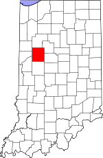
Tippecanoe County, Indiana Basics:


Tippecanoe County Indiana - Government Site

Population: 177,786
Area: 500 square miles
County seat: Lafayette
Area code(s) in use: 765
Time zone: EST
High school graduate or higher: 90.6%
Bachelor's degree or higher: 35.7%
Median household income: $44,047
Persons in poverty: 21.0%
Home ownership rate: 55.0%
Mean travel time to work: 17.5 minutes


Adjacent counties:
Benton  Carroll  Clinton  Fountain  Montgomery  Warren  White  

Find in Indiana

Map of the Tippecanoe County area


Our detail map of Tippecanoe County shows the Tippecanoe County, Indiana boundary lines and other interesting items.

Places in Tippecanoe County, Indiana

  Airports     show all on map

Agricultural Seed Airstrip, Aretz Airport, Dahnke Airport, Felix Airport, Grimes Farm Strip, Halsmer Airport, Miller Field, Purdue University Airport, Ratcliff Airport, Rush Airport, Sutton Airport, Timber House Airport, Wildcat Air Landing Area, Wyandotte Airport

  Bridges     show all on map

Grandville Bridge, Granville Bridge

  Buildings     show all on map

Americare Ambulance Service - Lafayette, Bennett's Greenhouse, Bloomer's Greenhouse, Clarks Hill Volunteer Fire Department, Knights of Pythias Home, Lafayette Fire Department Station 1, Lafayette Fire Department Station 2, Lafayette Fire Department Station 3, Lafayette Fire Department Station 5, Lafayette Fire Department Station 6, Lafayette Fire Department Station 7, Lafayette Fire Department Station 8, Lafayette Fire Department Station 9, Lafayette Fire Department Training Center, Lauramie Township Emergency Medical Services, Lauramie Township Fire Department, Ouiatenon Blockhouse, PHI Air Medical - Lafayette, Purdue University Fire Department, Randolph Township Volunteer Fire Department, Saint Vincent Seton Specialty Hospital Lafayette Campus, Shadeland Volunteer Fire Department, Sheffield Township Volunteer Fire Department, State Police Post Number 3, State Soldiers Home, Tippecanoe Township Volunteer Fire Department, Wabash Township Volunteer Fire Department Station 1, Wabash Township Volunteer Fire Department Station 2, Washington Township Buck Creek Fire Department, Wea Township Community Fire Department, West Lafayette Fire Department Station 1, West Lafayette Fire Department Station 2, West Lafayette Fire Department Station 3, West Point Volunteer Fire Association

  Canals     show all on map

Anderson Ditch, Blickenstaff Ditch, Bowen Ditch, Box Ditch, Brown Ditch, Buck Creek Ditch, Cole Ditch, Dewey Ditch, Edward Ditch, Elliott Ditch, Haywood Ditch, Hentz Ditch, Ilgenfritz Ditch, Kellerman Leaming Ditch, Kenny Ditch, Lofland Ditch, Marshall Ditch, McClure Ditch, McFarland Ditch, Montgomery Ditch, Moses Baker Ditch, O'Neall Ditch, Otterbein Ditch, Platt Ditch, Resser Ditch, Romney Fraley Ditch, Stock Farm Ditch, Stoddard Ditch, Wallace Ditch, Walters Ditch

  Cemeteries     show all on map

Americus Cemetery, Asbury Cemetery, Baker Cemetery, Battle Ground Cemetery, Cairo Cemetery, Clark Cemetery, Conarroe Cemetery, Concord Cemetery, Cunningham Cemetery, Durkee Cemetery, Elmwood Cemetery, Fairview Cemetery, Farmers Institute Cemetery, Fink Cemetery, Grandview Cemetery, Granville Cemetery, Harvey Cemetery, Hebron Cemetery, Hickory Grove Cemetery, Holladay Cemetery, Hollywood Cemetery, Johnson Cemetery, Kenny Cemetery, Marks Cemetery, Mintonye Cemetery, Newcomer Cemetery, North Union Cemetery, O'Neall Cemetery, Pierce Cemetery, Pretty Prairie Cemetery, Provault Cemetery, Resthaven Memorial Park, Saint Boniface Cemetery, Saint Joe Cemetery, Saint Johns Cemetery, Saint Marys Cemetery, Salem Cemetery, Sand Ridge Cemetery, Shambaugh Cemetery, Shelby Cemetery, Sherry Cemetery, Shoemaker Cemetery, Spencer Cemetery, Spring Grove Cemetery, Springvale Cemetery, Stingley Cemetery, Sugar Grove Cemetery, Swank Cemetery, Swisher-Hurtz Cemetery, Tippecanoe Memory Gardens Cemetery, Union Cemetery, Union Cemetery, Wheeler Grove Cemetery, Wildcat Cemetery, Wyandot Cemetery, Yorktown Cemetery, Zion Cemetery

  Census     show all on map

Americus Census Designated Place, Buck Creek Census Designated Place, Colburn Census Designated Place, Montmorenci Census Designated Place, Purdue University Census Designated Place, Stockwell Census Designated Place, West Point Census Designated Place

  Churches     show all on map

Bethany Church, Bethel Church, Christ Memorial Temple, Conroe Church, Fairview Church, Farmers Institute Church, Grace Church, Kingdom Hall Church, Liberty Chapel, Mount Zion Church, Oxford Church, Saint Lawrence Convent, Saint Pauls Church, Sharon Chapel, Stidham Church, Weaver Chapel

  Crossings     show all on map

Interchange 168, Interchange 172, Interchange 175, Interchange 178

  Dams     show all on map

Pretty Prairie Creek Road Dam, Rutan Farms Lake Dam

  Hospitals     show all on map

Home Hospital (historical), Saint Elizabeth Medical Center, Wabash Valley Hospital

  Islands     show all on map

Colliers Island, Goose Island

  Lakes     show all on map

Hadley Lake

  Locales     show all on map

Ayr-Way Lafayette Shopping Center, Battle Ground Campground, Edwood Glen Country Club, Elks Country Club, Lafayette Country Club, Linden Conservation Club, Mar-Jean Shopping Center, Market Square Shopping Center, Purdue University Forest Laboratory, Purdue University Poultry Farm, Ross-Ade Stadium, Tippecanoe Conservation Club

  Mines     show all on map

Fairfield Pit

  Parks     show all on map

Cary Camp, Columbian Park, Murdock Park, Ross Camp, Sycamore Valley Camp, Tippecanoe Battlefield Memorial

  Pillars     show all on map

Prophet Rock

  Populated Places     show all on map

Altamont Switch, Americus, Ash Grove, Bar-Barry Heights, Battle Ground, Birmingham, Buck Creek, Cairo, Clarks Hill, Colburn, Concord, Corwin, Crumb Corner, Dayton, Delp, Eastwitch, Elston, Gladens Corner, Glenhall, Green Meadows, Happy Hollow Heights, Heath, Indian Village, Klondike, Lafayette, McQuinn Estates, Meadowbrook, Monitor, Monroe, Montmorenci, Norma Jean Addition, North Crane, Octagon, Odell, Old Halfway, Pettit, Ravinamy, Romney, Shadeland, South Raub, Stockwell, Summit, Taylor, Tecumseh, Wabash Shores, West Lafayette, Westpoint, Wyandot

  Reservoirs     show all on map

Purdue University Pond, Rutan Farms Lake

  Schools     show all on map

Battle Ground Elementary School, Battle Ground Junior High School, Cary Home for Children, Clarks Hill Elementary School, Crouch Elementary School, Dayton Elementary School, East Tipp Junior High School, Edgelea Elementary School, Frank A Burtsfield Elementary School, George R Durgan Elementary School, Highland School, Jefferson Senior High School, Klondike Elementary School, Klondike Junior High School, Linnwood Elementary School, Longlois School, Monitor School, Morton Elementary School, Murdock Elementary School, Oakland Elementary School, Purdue University, Purdue University Agronomy Farm, Purdue University Dairy Farm, Purdue University Experimental Farm, Purdue University Farm Center, Purdue University Horticulture Farm, Purdue University Livestock Farm, Purdue University Veterinarian Farm, Saint Lawrence Elementary School, Saint Mary Cathedral School, Shadeland School, Southwestern Junior High School, Sunnyside Junior High School, Tecumseh Junior High School, Tippeecanoe School, Township School, Vinton Elementary School, Washington Elementary School, Wea School, West Lafayette Senior High School

  Springs     show all on map

Monitor Springs

  Streams     show all on map

Big Shawnee Creek, Bowers Creek, Bridge Creek, Buck Creek, Burnett Creek, Dismal Creek, Dry Run, East Branch Wea Creek, Finley Creek, Flint Run, Goose Creek, Harrison Creek, Hog Run, Indian Creek, Jordan Creek, Lauramie Creek, Little Flint Creek, Little Sugar Creek, Little Wea Creek, Lost Creek, Middle Fork Wildcat Creek, South Fork Wildcat Creek, Southworth Branch, Tippecanoe River, Wea Creek, Wildcat Creek

  Summits     show all on map

The Mound

  Swamps     show all on map

Mulvey Pond

  Towers     show all on map

WBAA-AM (West Lafayette), WFTE-AM (Lafayette), WPGW-AM (Portland), WXVW-AM (Lafayette)

  Valleys     show all on map

Cedar Hollow, Happy Hollow,

Tippecanoe County, Indiana Population By Race (2012 estimate)

RacePopulation
WhiteTippecanoe County White population 153,963153,962  
AsianTippecanoe County Asian population 11,55611,556
BlackTippecanoe County Black population 8,1788,178
MixedTippecanoe County Mixed population 3,3783,377
American IndianTippecanoe County American Indian population 711711
Hawaiian & Pacific IslanderTippecanoe County Hawaiian & Pacific Islander population 178177

Additional population tables :
State population table
Indiana population by county