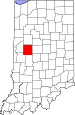
Montgomery County, Indiana Basics:


Montgomery County Indiana - Government Site

Population: 38,245
Area: 505 square miles
County seat: Crawfordsville
Area code(s) in use: 765
Time zone: EST
High school graduate or higher: 86.7%
Bachelor's degree or higher: 17.6%
Median household income: $46,026
Persons in poverty: 16.9%
Home ownership rate: 71.1%
Mean travel time to work: 20.0 minutes


Adjacent counties:
Boone  Clinton  Fountain  Hendricks  Parke  Putnam  Tippecanoe  

Find in Indiana

Map of the Montgomery County area


Our detail map of Montgomery County shows the Montgomery County, Indiana boundary lines and other interesting items.

Places in Montgomery County, Indiana

  Airports     show all on map

Babcocks Airport, Crawfordsville Municipal Airport, Meharry AG Service Airport, Shades State Park Airport, Townsend Airport, Wilkins Strip Airport

  Bridges     show all on map

Davis Bridge

  Buildings     show all on map

Coal Creek Township Volunteer Fire Department Station 1, Coal Creek Township Volunteer Fire Department Station 2, Crawfordsville Fire Department Station 1, Crawfordsville Fire Department Station 2, Darlington Fire Department, Ladoga Volunteer Fire Department, Linden - Madison Township Volunteer Fire Department, New Market Volunteer Fire Department, Ripley Township Volunteer Fire Department, S - W Rescue Services, Statewide Transfer Ambulance and Rescue, Walnut Township Fire Department, Waveland Volunteer Fire Department, Waynetown Community Volunteer Fire and Rescue

  Canals     show all on map

Armentrout Dredge Ditch, Charles Ludlow Ditch, Clarkson Ditch, Cross Ditch, Gray Ditch, Joseph Ludlow Ditch, McFarland Ditch, Needham Booher Ditch, Sommer Ditch

  Cemeteries     show all on map

Ben Hur Cemetery, Bowers Cemetery, Breaks Cemetery, Calvary Cemetery, Clouser Cemetery, Coons Cemetery, Finley Chapel Cemetery, Fruits Cemetery, Galey Cemetery, Greenlawn Cemetery, Harshbarger Cemetery, Harshbarger Cemetery, Hicks Cemetery, Hutton Cemetery, Independent Order of Odd Fellows Cemetery, Indian Creek Cemetery, Indian Creek Hill Cemetery, Inlow Cemetery, James Cemetery, Jones Cemetery, Lutheran Cemetery, Lydick Cemetery, Maple Ridge Cemetery, Meharry Cemetery, Michael Cemetery, Mount Pleasant Cemetery, Mount Pleasant Cemetery, New Ross Cemetery, Nutt Cemetery, O'Neal Cemetery, Oak Hill Cemetery, Oakland Cemetery, Old Hickory Cemetery, Old Pottinger Cemetery, Old Turkey Run Cemetery, Old Union Cemetery, Oldtown Cemetery, Peterson Cemetery, Pisgah Cemetery, Pleasant Hill Cemetery, Potts Cemetery, Rice Cemetery, Sidener Cemetery, Sparks Cemetery, Stonebraker Cemetery, Stoner Cemetery, Stover Cemetery, Thompson Cemetery, Wasson Cemetery, Wasson Cemetery, Weir Cemetery, Wesley Cemetery, Wilhite Cemetery, Willhite Cemetery, Wilson Cemetery, Wilson Killen Cemetery, Yountsville Cemetery

  Census     show all on map

Lake Holiday Census Designated Place

  Churches     show all on map

Center Church, Christian Union Church, Freedom Church, Gravelly Run Church, Haw Creek Church, Liberty Chapel, Potato Creek Church, Providence Church, Saint James Church, Union Chapel, Youngs Chapel

  Dams     show all on map

Holiday Lake Dam, Little Raccoon Structure Number 8, Shades Pond Dam, Sportsmans Club Lake Dam

  Hospitals     show all on map

Saint Clare Medical Center

  Lakes     show all on map

C Moore Lake, Morrison Lake

  Locales     show all on map

Alamo Conservation Club, Sportsmen Club, Spring Ledge Country Club, Waveland Conservation Club

  Parks     show all on map

Camp Rotary, Cold Spring Camp, Ladoga Rest Park, Lake Waveland Park, Milligan Park

  Populated Places     show all on map

Alamo, Ames, Beckville, Bowers, Browns Valley, Cherry Grove, Crawfordsville, Darlington, Darlington Woods, Deer Mill, Elmdale, Fiskville, Garfield, Hibernia, Kirkpatrick, Ladoga, Lake Holiday, Lapland, Linden, Linnsburg, Log Cabin Crossroads, Mace, Manchester, New Market, New Richmond, New Ross, North Union, Parkersburg, Shannondale, Smartsburg, Sycamore Ford, Taylor Corner, Waveland, Waynetown, Wesley, Whitesville, Wingate, Yountsville

  Post Offices     show all on map

Bowers Post Office (historical), Clousers Mills Post Office (historical)

  Reservoirs     show all on map

Lake Holiday, Lake Waveland, Pennington Lake, Shades Pond, Sportsmans Club Lake

  Ridges     show all on map

Devils Backbone

  Schools     show all on map

Anna Wilson Elementary School, Caleb Mills Elementary School, Coal Creek Central School, Crawfordsville Senior High School, Darlington Elementary and Junior High School, Horace Mann School, John Beard Elementary School, Joseph F Tuttle Junior High School, Lagoda Elementary School, Laura Hose Elementary School, Liberty School, Linden Elementary School, Meredith Nicholson Elementary School, Mill School, Mollie B Hoover Elementary School, Mount Zion School, New Market Elementary School, Nicholson School, Tuttle School, Wabash College, Walnut Elementary School, Waveland Elementary School, Waynetown Elementary and Junior High School, Wilson School

  Streams     show all on map

Black Creek, Compton Branch, Corner Creek, Davis Branch, Demeree Creek, Dry Branch, Dry Run, Haw Creek, Hazel Creek, Honey Creek, Indian Creek, Karnes Creek, Little Creek, Little Potato Creek, Little Raccoon Creek, Little Sugar Creek, Lye Creek, Lye Creek Drain, Mill Creek, Mud Run, North Fork Coal Creek, Offield Creek, Old Shoe Branch, Rattlesnake Creek, Smith Branch, Spencer Branch, Stillwater Creek, Stonebraker Branch, Turkey Run, Walnut Fork Sugar Creek, Withe Creek

  Summits     show all on map

Truax Hill

  Towers     show all on map

WCVL-AM (Crawfordsville), WLFQ-FM (Crawfordsville), WNDY-FM (Crawfordsville),

Montgomery County, Indiana Population By Race (2012 estimate)

RacePopulation
WhiteMontgomery County White population 36,98336,982  
MixedMontgomery County Mixed population 459458
BlackMontgomery County Black population 421420
AsianMontgomery County Asian population 229229
American IndianMontgomery County American Indian population 153152
Hawaiian & Pacific IslanderMontgomery County Hawaiian & Pacific Islander population 00

Additional population tables :
State population table
Indiana population by county