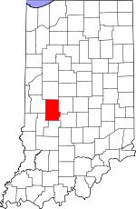
Putnam County, Indiana Basics:


Putnam County Indiana - Government Site

Population: 37,645
Area: 481 square miles
County seat: Greencastle
Area code(s) in use: 765
Time zone: EST
High school graduate or higher: 85.7%
Bachelor's degree or higher: 16.6%
Median household income: $50,480
Persons in poverty: 10.9%
Home ownership rate: 79.1%
Mean travel time to work: 29.4 minutes


Adjacent counties:
Clay  Hendricks  Montgomery  Morgan  Owen  Parke  

Find in Indiana

Map of the Putnam County area


Our detail map of Putnam County shows the Putnam County, Indiana boundary lines and other interesting items.

Places in Putnam County, Indiana

  Airports     show all on map

4 Winds Aerodrome, Bainbridge Half Mile Airport, Clover Knoll Airport, Durham Airport, Hampton Field Airport, Oleo Airport, Owens Field Airport, Putnam County Airport, Sanders Gyroport, Way West Airport

  Beaches     show all on map

Hulman Beach

  Bridges     show all on map

Bakers Camp Covered Bridge, Collins Covered Bridge, Crow Bridge, Dunbar Covered Bridge, Higgins Bridge, Houck Bridge, Houck Covered Bridge, Huffman Covered Bridge, Manhatten Covered Bridge, Oakalla Covered Bridge, Pine Bluff Bridge, Pinhook Bridge, Rolling Stone Bridge, Wildwood Bridge

  Buildings     show all on map

Bainbridge Fire Department, Bainbridge Volunteer Fire Department, Cloverdale Township Fire Department, Fillmore Volunteer Fire Department, Floyd Township Fire and Rescue, Greencastle Fire Department, Jefferson Township Volunteer Fire Department, Madison Township Volunteer Fire Department, Putnam County Operation Life, Putnam County Operation Life - Cloverdale Substation, Putnamville Correctional Facility Fire Department, Reelsville - Washington Township Volunteer Fire Department, Roachdale Fire Department, Russellville and Community Volunteer Fire Department, Van Bibber Lake Volunteer Fire Department

  Canals     show all on map

Lake Ditch, Mill Creek Ditch, Mill Creek Ditch

  Cemeteries     show all on map

Bainbridge Cemetery, Bakesburg Cemetery, Biddle Cemetery, Boone Cemetery, Boone-Hutcheson Cemetery, Carmel Cemetery, Clear Creek Cemetery, Coffman Cemetery, Doe Creek Cemetery, Fillmore Cemetery, Flatwoods Cemetery, Forest Hill Cemetery, Forgey Cemetery, Girton Cemetery, Grable Cemetery, Greeley Cemetery, Grider Cemetery, Groveland Cemetery, Hartman Cemetery, Hebron Cemetery, La Follett Cemetery, Landes Cemetery, Liberty Cemetery, Little Walnut Cemetery, Matkin Cemetery, Mill Creek Cemetery, Mount Pleasant Cemetery, New Providence Cemetery, Nicolas Cemetery, Old Bethel Cemetery, Old Union Cemetery, Peffley Cemetery, Pickle Cemetery, Pisgah Cemetery, Randel Cemetery, Roachdale Cemetery, Salem Cemetery, Skillman Cemetery, Sutherlin Cemetery, Wesley Chapel Cemetery

  Census     show all on map

Heritage Lake Census Designated Place, Van Bibber Lake Census Designated Place

  Churches     show all on map

Antioch Church, Beach Grove Church, Bethel Church, Big Walnut Church, Canaan Church, Canaan Church, Community Church, Croys Creek Church, Deer Creek Church, Long Branch Church, Mount Hebrow Church, Mount Olivet Church, Otter Creek Church, Palestine Church, Pleasant Hill Church, Sherwood Church, Smyrna Church, Somerset Church, Tri-County Community Church, Union Chapel, Union Valley Church, Walnut Chapel

  Cliffs     show all on map

Fern Cliff

  Dams     show all on map

Albin Pond Dam, Banks Lake Dam, Cagles Mill Lake Dam, Dogwood Springs Lake Dam, Edgewood Lake Dam, Elmer Martens Lake Dam, Greyhound Lake Dam, Heritage Lake Dam, Little Walnut Creek Structure Number 3, Okalla Lake Dam, Van Bibber Lake Dam

  Falls     show all on map

Vermillion Falls

  Forests     show all on map

Owen-Putnam State Forest

  Hospitals     show all on map

Putnam County Hospital

  Lakes     show all on map

Thomas Lake

  Locales     show all on map

Okalla Station

  Mines     show all on map

Cloverdale Quarry, Limedale Quarry, Manhattan Quarry, Putnam County Stone Pit

  Parks     show all on map

Jaycee Park, Krietenste Camp, Richard Lieber State Park, Robe Ann Park

  Populated Places     show all on map

Bainbridge, Barnard, Belle Union, Blakesburg, Board Park, Brick Chapel, Broad Park, Brunerstown, Cagle Mill, Carpentersville, Cary, Clinton Falls, Cloverdale, Cradick Corner, Edgewood Lake, Fillmore, Fincastle, Fox Ridge, Greencastle, Groveland, Heritage Lake, Hirt Corner, Jenkinsville, Keytsville, Limedale, Manhattan, Morton, Mount Meridian, New Maysville, Pleasant Gardens, Portland Mills, Putnamville, Raab Crossroads, Raccoon, Reelsville, Roachdale, Russellville, Van Bibber Lake, Vivalia, Westland

  Post Offices     show all on map

Hamricks Station Post Office (historical), Malta Station Post Office (historical)

  Reservoirs     show all on map

Albin Pond, Baire Lake, Banks Lake, Dogwood Springs Lake, Edgewood Lake, Elmer Martens Lake, Glenn Flint Lake, Greyhound Lake, Heritage Lake, Oakalla Lake, Quarry Pond, Thomas Lake, Van Bibber Lake

  Ridges     show all on map

Devils Backbone, Indian Ridge

  Schools     show all on map

Bainbridge Elementary School, Belle Union Elementary School, Cloverdale Elementary School, Cloverdale Junior/Senior High School, DePauw University, Fillmore Elementary School, Greencastle Junior High School, Greencastle Senior High School, Martha J Ridpath Elementary School, Mary Emma Jones Elementary School, Miller School, Northeast Elementary School, Reelsville Elementary School, Russellville Elementary School, South Putnam High School

  Streams     show all on map

Beacon Run, Belle Union Branch, Big Walnut Creek, Bledsoe Branch, Bullet Branch, Byrd Branch, Canaan Run, Church Creek, Clear Creek, Cline Creek, Cornstalk Creek, Cotton Branch, Crooked Branch, Croys Creek, Deer Creek, Deweese Branch, Doe Creek, Dry Branch, Dyer Creek, Fall Creek, Falls Branch, Ferguson Branch, Girton Run, Higgins Branch, Johnson Branch, Jones Creek, Leatherman Creek, Leatherwood Creek, Lick Creek, Limestone Creek, Little Deer Creek, Little Walnut Creek, Long Branch, Lower Limestone Creek, Maiden Run, Mill Creek, Miller Creek, Mosquito Creek, Mud Creek, North Fork Jordan Creek, North Ramp Creek, Owl Branch, Owl Creek, Peters Creek, Plum Creek, Plum Creek, Rabbit Run, Ramp Creek, Rhodes Creek, Rocky Fork, Sallust Branch, Slate Run, Snake Creek, Snyder Branch, Son Run, South Fork Little Raccoon Creek, South Ramp Creek, Union Branch, Upper Limestone Creek, Vermillion Branch, Wallace Branch

  Summits     show all on map

Bald Hill, Hadden Hill, Hughes Hill, McCoy Hill, Moser Hill, Snyder Hill, Sunset Hill

  Towers     show all on map

WGRE-FM (Greencastle), WJNZ-FM (Greencastle)

  Valleys     show all on map

Green Hollow,

Putnam County, Indiana Population By Race (2012 estimate)

RacePopulation
WhitePutnam County White population 35,31135,311  
BlackPutnam County Black population 1,5061,505
MixedPutnam County Mixed population 414414
AsianPutnam County Asian population 301301
American IndianPutnam County American Indian population 113112
Hawaiian & Pacific IslanderPutnam County Hawaiian & Pacific Islander population 00

Additional population tables :
State population table
Indiana population by county