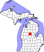
Clare County, Michigan Basics:


Clare County Michigan - Government Site

Population: 30,751
Area: 564 square miles
County seat: Harrison
Area code(s) in use: 989
Time zone: EST
High school graduate or higher: 84.1%
Bachelor's degree or higher: 11.1%
Median household income: $33,334
Persons in poverty: 24.8%
Home ownership rate: 80.3%
Mean travel time to work: 26.4 minutes


Adjacent counties:
Gladwin  Isabella  Mecosta  Midland  Missaukee  Osceola  Roscommon  

Find in Michigan

Map of the Clare County area


Our detail map of Clare County shows the Clare County, Michigan boundary lines and other interesting items.

Places in Clare County, Michigan

  Airports     show all on map

Clare County Airport, Clare Municipal Airport, Doss Field Airport, Scott Airstrip

  Bridges     show all on map

Church Bridge, Jonesville Bridge

  Buildings     show all on map

Arthur Township Hall, Charles A Amble Library, Clare City Hall, Clare County Historical Society and Museum, Clare County Sheriff's Office, Clare Fire Department, Clare Police Department, Clare Welcome Center, Farwell Historical Museum, Frost Township Police Department, Garfield Memorial Library, Garfield Township Fire Department, Harrison City Library, Harrison Community Fire Department Station 1 Headquarters, Harrison Sheriff's Office, Lincoln Township Fire Department, Lincoln Township Hall, Michigan Department of Natural Resources Harrison Field Office, Mobile Medical Response Station 31, Sheridan Township Hall, Surrey Township Fire Department, Surrey Township Public Library, United Rescue Service

  Cemeteries     show all on map

Arthur Cemetery, Cedar View Cemetery, Cherry Grave Cemetery, Elm Grove Cemetery (historical), Fernwood Cemetery, Freeman Cemetery, Frost Township Cemetery, Garfield Cemetery, Garrity Cemetery, Greenwood Cemetery, Hamilton Cemetery, Hatton Township Cemetery, Lincoln Township Cemetery, Maple Grove Cemetery, Meridith Cemetery, Old Township Cemetery, Ott Cemetery, Pleasant Plains Cemetery, Saint Athanasius Cemetery, Saint Cecilia Cemetery, Saint John's Lutheran Cemetery, Summerfield Cemetery, Surrey Cemetery, Thompson Cemetery, Wilson Grove, Winterfield Cemetery, Wood Cemetery

  Churches     show all on map

Andersen Chapel, Arthur Center Church, Assembly of God Church, Bethany Baptist Church, Brown Corners Church, Church of Christ, Church of God in Christ, Church of Jesus Christ of Latter-Day Saints, Church of Nazarene, Clare Christ Fellowship Church, Clare Congregational United Church of Christ, Clare United Methodist Church, Colonville Bible Church, Community Baptist Church, Community Church, Community Church, Community of Christ, Community of Christ Church, David Helm Chapel, Eagle Church, Evergreen Church, Faith Church, Farwell Church of Christ, Farwell Community Church, Farwell United Methodist Church, First Baptist Church, First Baptist Church of Clare, First Congregational United Church of Christ, Gathering United Methodist Church, Grace Bible Church, Harrison Church of Christ, Hope Baptist Church, Jehovah's Witnesses Clare, Jehovah's Witnesses Harrison, Lake Baptist Church, Latter-Day Saints Church, Liberty Baptist Church, Living Hope Lutheran Church, Long Lake Free Church, Maple Grove Church, Marion Full Gospel Church, Old Time Missionary Baptist Church, Prince of Peace Church, River of Hope Christian Church, Saint Athanasius Church, Saint Cecila Church, Saint John Evangelical Lutheran Church, Saint Johns Church, Saint Luke Church, Trinity Baptist Church, Victory Baptist Church

  Crossings     show all on map

Interchange 160, Interchange 162, Interchange 168, Interchange 170, Interchange 176

  Forests     show all on map

Airport Forest

  Hospitals     show all on map

Central Clinic-Harrison, Mid Michigan Medical Center, Mid Michigan Medical Center - Clare, Mid Michigan Physicians Group, North Woods Nursing Center, Tendercare of Clare

  Lakes     show all on map

Arnold Lake, Bailey Lake, Bass Lake, Bass Lake, Bear Lake, Beebe Lake, Bertha Lake, Big Cranberry Lake, Big Dollar Lake, Big Mud Lake, Big Norway Lake, Black Louie Bayou, Bluegill Lake, Bluff Lake, Boathouse Lake, Boyles Creek, Budd Lake, Bungo Lake, Canada Lake, Caner Lakes, Clear Lake, Cranberry Lake, Cranberry Lakes, Crooked Lake, Currey Lake, Deadman Lake, Decker Lake, Deer Lake, Devil Lake, Dishpan Lake, Doc and Tom Lake, Dodge Lake, Dollar Lake, Dollar Lake, Drachenburg Lake, Dunham Lake, East Trout Lake, Eight Point Lake, Elbow Lake, Eureka Lake, Finley Lake, Five Lakes, Frost Lake, Furgeson Lake, Glosch Lake, Grass Lake, Grass Lake, Gray Lake, Green Pine Lake, Gut Lake, Half Moon Lake, Halfmoon Lake, Handy Lake, Harrington Bayou, Haskell Lake, Haven Lake, Hemlock Lake, Howland Lake, Icehouse Lake, Johnny Lake, Kilborne Lake, Lake Enola, Lake Ernestine, Lake George, Lake Little George, Lake Shamrock, Lake Taho, Lake Thirteen, Lawrence Lake, Lily Lake, Lily Lake, Lindy Lake, Little Long Lake, Little Loon Lake, Little Norway Lake, Little Silver Lake, Little Sunrise Lake, Long Lake, Long Lake, Long Pond, Loon Lake, Lost Lake, Lower Brennan Lake, McWatty Lake, Mill Pond, Minnow Lake, Mud Lake, Mud Lake, Mud Lake, Muir Lake, Mystic Lake, Nestor Lakes, Norway Lake, Otter Lake, Owl Lake, Perch Lake, Perch Lake, Perch Lake, Pfannes Lake, Pike Lake, Pixley Pond, Rice Pond, Rollway Lake, Round Lake, Russell Lake, Sand Lake, Schiemann Lake, Schoomaker Lake, Shingle Lake, Shively Lake, Silver Lake, South Lake, Spring Lake, Springwood Lakes, Starkey Lake, Surrey Lake, Sutherland Lake, Three Lake, Thurston Lake, Townline Lake, Townline Lake, Trout Lake, Tuohy Lake, Turbush Lake, Twin Lakes, Upper Brennan Lake, We-E Lake, West Trout Lake, White Sand Lake, Windover Lake, Wolf Lake, Wood Lake

  Locales     show all on map

Browns Corners, Camp Deer Trails, Camp Neyati, Camp Oak Hill, Camp Rotary, Camp Summer Trails, Cedar Shores Campground, Clare County Fairground, Clarence Station (historical), Countryside Campgrounds, Devil's Knob Golf Course, Downhours Shady Acres Campground, Eagle Glen Golf Course, Farwell Station, Firefly Golf Links, Harrison Station (historical), Hatton Station (historical), Hidden Hill Family Campground, Lake George Campground, Lake George Station, Lake Station (historical), Leota Mall, Lost Lake Camp, Mud Lake State Forest Campground, Parker's Trailer Park and Camp, Pennock Station, Phelps Station, River Valley RV Park, Snow Snake Golf Course, Snow Snake Mountain Ski Area, Tamaracks Golf Course, Temple Forest Campground, Temple Station

  Mines     show all on map

Mannsiding Pit

  Oilfields     show all on map

Cranberry Lake Oil and Gas Storage Field, Freeman-Redding Oil Field, North Hamilton Oil and Gas Field, Skeels Oil Field, West Hamilton Oil and Gas Field, Winterfield Oil and Gas Storage Field

  Parks     show all on map

Barnes Island Park, Brookwood Park, Clare City Park, Clare Congregational Church Historical Marker, Clark Memorial Park, Gerrish Railroad Roadside Park, Grant Township Park, Harrison Area Park, Harrison Historical Marker, Hayes Township Outdoor Park, Logging Railroads Historical Marker, Michigan's Petroleum Industry Historical Marker, Pettit Park, Shamrock Park, Shingle Lake Park, Stamina Stadium Park, Wilson State Park

  Populated Places     show all on map

Allendale, Ash Acres, Buck Trails, Clare, Colonville, Cooperton, Dover, Farwell, Harrison, Harrison Mobile Home Estates, Hatton, Lake, Lake George, Leota, Long Lake Heights, Meadows of Farwell Mobile Home Park, Meredith, Phelps, Piney Woods, Pleasant Valley Mobile Home Park, Rainbow Bend, Ruby's Mobile Home Park, Temple, Withi Trailer Park

  Post Offices     show all on map

Alward Post Office (historical), Austa Post Office (historical), Cairns Post Office (historical), Clare Post Office, Clarence Post Office (historical), Colonville Post Office (historical), Dodge Post Office (historical), Dover Post Office (historical), Farwell Post Office, Grandon Post Office (historical), Harrison Post Office, Hatton Post Office (historical), Lake George Post Office, Lake Post Office, Leota Post Office (historical), Longlake Post Office (historical), Mark Post Office (historical), Meredith Post Office (historical), Mosteller Post Office (historical), Pennock Post Office (historical), Prestel Post Office (historical), Summerfield Post Office (historical), Temple Post Office (historical), Tonkin Post Office (historical), Upton Post Office (historical), Wade Post Office (historical), Winterfield Post Office (historical)

  Reservoirs     show all on map

Floodwood Swamp Reservoir

  Schools     show all on map

Amble School, Clare High School, Clare Middle School, Clare Primary School, Clare-Gladwin School, Doty School, Farwell Area Middle School, Farwell Elementary School, Farwell High School, Grandon School, Harrison Senior High School, Hillside Elementary School, Larson School, Long Lake School, Mid-Michigan Community College, Randall School, Redner School

  Streams     show all on map

Bailey Creek, Beaver Creek, Carrow Creek, Clam River, Clear Creek, Cranberry Creek, Cranberry Creek, Dishwash Creek, Elm Creek, Five Lakes Creek, Floodwood Creek, Giss-I-Was Creek, Green Creek, Grey Creek, Halford Creek, Harden Creek, Hemlock Creek, Jose Creek, Little Norway Creek, Loon Lake Creek, McCuran Creek, Middle Branch Cedar River, Mostellar Creek, Newton Creek, Norway Creek, Overton Creek, Popple Creek, Prestle Creek, Runyon Creek, Sanford Creek, Shingle Creek, South Branch Town Line Creek, Spike Horn Creek, Spike Horn Creek, Three Lake Creek, Town Line Creek, West Branch Cedar River, West Branch Clam River, Whisky Creek, White Sand Creek

  Summits     show all on map

Blue Mountain, McWatty Knoll

  Swamps     show all on map

Bear Swamp, Deadman Swamp, Floodwood Swamp, Muddy Bayou, Sandy Bayou, Spike Horn Swamp, Warner Bayou

  Towers     show all on map

Farwell Lookout Tower, Harrison Lookout Tower, WABX-AM (Clare), WKKM-FM (Harrison), WWKM-AM (Harrison),

Clare County, Michigan Population By Race (2012 estimate)

RacePopulation
WhiteClare County White population 29,79829,797  
MixedClare County Mixed population 431430
American IndianClare County American Indian population 215215
BlackClare County Black population 185184
AsianClare County Asian population 9292
Hawaiian & Pacific IslanderClare County Hawaiian & Pacific Islander population 00

Additional population tables :
State population table
Michigan population by county