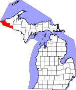
Gogebic County, Michigan Basics:


Gogebic County Michigan - Government Site

Population: 16,064
Area: 1102 square miles
County seat: Bessemer
Area code(s) in use: 906
Time zone: CST
High school graduate or higher: 91.8%
Bachelor's degree or higher: 18.7%
Median household income: $34,397
Persons in poverty: 18.9%
Home ownership rate: 76.2%
Mean travel time to work: 18.2 minutes


Adjacent counties:
Iron  Iron (WI)  Ontonagon  Vilas (WI)  

Find in Michigan

Map of the Gogebic County area


Our detail map of Gogebic County shows the Gogebic County, Michigan boundary lines and other interesting items.

Places in Gogebic County, Michigan

  Airports     show all on map

Gogebic-Iron County Airport, Hide-Away Village Landing Strip, Marenisco Landing Field, Northwoods Airport

  Bays     show all on map

Big Bear Bay, Bingham Bay, Ice House Bay, Little Bear Bay, Misery Bay, Montgomery Bay, Pabst Bay, Rice Bay

  Buildings     show all on map

Bessemer Fire Department, Bessemer Public Library, Bessemer Township Volunteer Fire Department, Campus Suites Residence Hall, Carl Kleimola Applied Technology Center, Carnegie Library, Construction Technology Annex, David G Lindquist Student Center, Gogebic County Courthouse, Gogebic County Home, Gogebic County Sheriff's Office, Ironwood Department of Public Safety, Ironwood Fire Department, Ironwood Police Department, Ironwood Township Volunteer Fire Department, Jacob Solin Center for Business Education, Lac Vieux Desert Tribal Police Department, Lake Gogebic Volunteer Fire Department Station 2 - East Shore, Lake Gogebic Volunteer Fire Department Station 2 West Shore, Marenisco Ambulance, Marenisco Township Police Department, Marenisco Volunteer Fire Department, Mount Zion Ski Chalet, Ojibway Correctional Facility, Pat O'Donnell Civic Center, Rutger Erickson Academic Center, United States Forest Service Watersmeet Ranger District, Wakefield City Library, Wakefield Police Department, Wakefield Volunteer Fire Department, Watersmeet Township Volunteer Fire Department

  Capes     show all on map

Alligator Point, Desolation Point, Indian Point, Killarney Point, Little Girls Point, Montgomery Point

  Cemeteries     show all on map

Hillcrest Cemetery, Historic Indian Burial Grounds, Katakikon Indian Village Cemetery, Lakeside Cemetery, Marenisco Township Cemetery, Riverside Cemetery, Watersmeet Township Cemetery

  Census     show all on map

Marenisco Census Designated Place, Watersmeet Census Designated Place

  Churches     show all on map

All Saints Lutheran Church, Apostolic Lutheran Church, Assembly of God Church, Calvary Baptist Church, Cornerstone Christian Church, First Presbyterian Church, Grace Baptist Church, Grace Community Fellowship, Grace Open Church, Hope Church, Immaculate Conception Church, Immaculate Conception Church, Immanuel Church, Jehovahs Witness Kingdom Hall, Keepers of the Faith Church, Lighthouse Faith Center, Living Water Missionary Church, Living Water Missionary Church, Notre Dame Church, Our Lady of Peace Church, Our Redeemer Lutheran Church, Peterson Chapel, Saint Catherine Catholic Church, Saint John Church, Saint Paul Lutheran Church, Saint Sebastian Church, Salem Lutheran Church, Seventh-Day Adventist Church, Sharon Lutheran Church, Transfiguration Episcopal Church, Trinity Lutheran Church, Wakefield United Methodist Church, Watersmeet Baptist Church, Wesley United Methodist Church, Woodland Church, Zion Evangelical Lutheran Church

  Falls     show all on map

Abinodji Falls, Ajibikika Falls, Algonquin Falls, Bathtub Falls, Big Carp Falls, Chippewa Falls, Explorers Falls, Gabbro Falls, Gorge Falls, Granite Falls, Great Conglomerate Falls, Iagoo Falls, Interstate Falls, Judson Falls, Kakabika Falls, Lepisto Falls, Manabezho Falls, Manakiki Falls, Manido Falls, Maple Creek Falls, Marshall Falls, Mex-i-min-e Falls, Nawadaha Falls, Neepikon Falls, Nelson Canyon Falls, Nokomis Falls, Ogima Falls, Ogimakwe Falls, Peterson Falls, Pinkerton Falls, Potawatomi Falls, Powder Horn Falls, Rainbow Falls, Rocky Forty Falls, Root Beer Falls, Sandstone Falls, Saxon Falls, Shining Cloud Falls, Superior Falls, Traders Falls, Trappers Falls, Yondota Falls

  Hospitals     show all on map

Duluth Clinic, Grand View Clinic, Grand View Hospital, Josephsons Nursing Home, Lac Vieux Desert Clinic, Rocco Medical Clinic, South Shore Orthopedics, Watersmeet Medical Clinic

  Islands     show all on map

Draper Island, Near Island, Reimers Island

  Lakes     show all on map

Albino Lake, Allen Lake, Amik Lake, Anderson Lake, Arnested Lake, Banks Lake, Banner Lake, Barb Lake, Basin Lake, Basin Lake, Bass Lake, Bay Lake, Beatons Lake, Beaver Dam Lake, Beaver Pond, Beaver Station Lake, Bee Lake, Bergner Lake, Big African Lake, Big Bateau Lake, Big Mosquito Lake, Birch Lake, Black River Lake, Bluebell Lake, Bluegill Lake, Bluegill Pond, Bluejay Lake, Bobcat Lake, Bracken Lake, Brown Lake, Brush Lake, Buck Lake, Buckthorn Lake, Castle Lake, Chaney Lake, Chickadee Lake, Chokecherry Lake, Cisco Lake, Clark Lake, Clear Lake, Clearwater Lake, Cloverleaf Lake, Copper Pond, Corey Lake, Cornelia Lake, Corssbill Lake, Cowslip Lake, Cox Lake, Coyote Lake, Cranberry Lake, Crane Lake, Crazy Bear Lake, Crooked Lake, Crossbill Lake, Croziers Lake, Crystal Lake, Cub Lake, Cup Lake, Cutters Pond, Cyrus Lake, Daisy Lake, Damon Lake, Davis Lake, Dawn Lake, Deer Island Lake, Deeryard Lake, Dellies Lake, Devils Head Lake, Dinner Lake, Dorothy Lake, Down Lake, Downy Lake, Doyle Lake, Dream Lake, Drone Lake, Duck Lake, Dumbbell Lake, Dutch Lake, Dwarf Lake, Eagle Lake, East Bay Lake, East Bear Lake, Eel Lake, Elbow Lake, Eleanore Lake, Elsie Lake, Emeline Lake, Englesby Lake, Feather Lake, Finger Lake, Finn Pond, Fisher Lake, Fishhawk Lake, Fleury Lake, Flicker Lake, Florence Lake, Foggy Lake, Foxpaw Lake, Gallagher Lake, Gaylord Lake, Germain Lake, Glen Lake, Glimmerglass Lake, Grace Lake, Grass Lake, Gray Lake, Gudegast Lake, Guides Lake, Hartley Lake, Hattie Lake, Hawk Lake, Hawthorn Lake, Hay Lake, Heart Lake, Helen Lake, Henry Lake, Heron Lake, Hidden Lake, High Lake, Hilltop Lake, Hogala Lake, Hoist Lake, Holly Lake, Honey Lake, Honey Lake, Honeysuckle Lake, Honk Lake, Hook Lake, Horseshoe Lake, Hummingbird Lake, Image Lake, Imp Lake, Indian Lake, Inkpot Lake, Ishkote Lake, Jack Lake, Jacksnipe Lake, Jane Lake, Jay Lake, Jaybird Lake, Jennings Lake, Jingwak Lake, Jishib Lake, Joann Lake, Johnston Springs, Katherine Lake, Katie Lake, Kerr Lake, Kickapoo Lake, King Lake, Kinwamakwad Lake, Kunschke Lake, Kvidera Lake, Lake Audrey, Langford Lake, Liluis Lake, Lindsley Lake, Little African Lake, Little Beatons Lake, Little Castle Lake, Little Duck Lake, Little Langford Lake, Little Moon Lake, Little Mosquito Lake, Little Oxbow Lake, Little Pomeroy Lake, Little Trail Lake, Lois Lake, Long Lake, Loon Lake, Louise Lake, Lumberjack Lake, Lynx Lake, Mamie Lake, Marell Lake, Marion Lake, Marsh Lake, Mastodon Lake, Maud Lake, Mayflower Lake, McCullough Lake, McDonald Lake, Meander Lake, Michigan Bay, Midget Lake, Miller Lake, Mink Lake, Mishike Lake, Misty Lake, Moccasin Lake, Monk Lake, Moon Lake, Moraine Lake, Morley Lake, Morris Lake, Moss Lake, Mountain Lake, Mule Lake, Muskeg Lake, Musque Lake, Nansen Lake, Narrow Lake, Norwood Lake, Ogima Lake, Opal Lake, Orchard Lake, Orchid Lake, Ormes Lake, Osprey Lake, Ox Yoke Lake, Oxbow Lake, Paint River Springs, Pan Lake, Partridge Lake, Pats Lake, Pelton Pond, Perch Lake, Peter and Paul Lakes, Pigeon Lake, Pilot Lake, Pincherry Lake, Pit Lake, Plains Lake, Plains Lake, Plum Lake, Plymouth Lake, Pomeroy Lake, Poor Lake, Porcupine Lake, Powwow Lake, Quack Lake, Queen Lake, Range Lake, Raspberry Lake, Raven Lake, Record Lake, Redboat Lake, Reynolds Lake, Richard Lake, Rickles Lake, Ridge Lake, Roach Lake, Ross Lake, Sagaigan Lake, Sago Lake, Saint Augustine Lake, Scaup Lake, Schneider Lake, Scout Lake, Shadow Lake, Sharptail Lake, Sherman Pond, Siskin Lake, Slope Lake, Snap Jack Lake, Snowshoe Lake, Spider Lake, Spirit Lake, Spruce Lake, Stickley Lake, Stone Lake, Sucker Lake, Summit Lake, Sun Dance Lake, Sun Lake, Tamarack Lake, Taps Lake, Taylor Lake, Tea Lake, Teal Lake, Thousand Island Lake, Thrush Lake, Tomassi Lake, Trail Lake, Trapper Lake, Tuesday Lake, Twilight Lake, Twin Pups Lakes, Twist Lake, Wellington Lake, West Bay Lake, West Bear Lake, Whitefish Lake, Whitmore Lake, Wilson Lake, Wilson Springs, Winter Lake, Winterberry Lake, Wolf Lake

  Locales     show all on map

Alpine Trailer Park and Campground, Ash Campground, Badger Campground, Balsam Campground, Bass Campground, Bear Campground, Beaver Campground, Bessemer Station (historical), Birch Campground, Black Jack Ski Area, Black River Harbor Campground, Blacks Spur, Bobcat Campground, Bobcat Lake Campground, Bobcat Lake Picnic Area, Boulder Creek Golf Course, Burned Dam Camp, Camp Ojibway, Cedar Campground, Chipmunk Campground, Clark Lake Picnic Area, Coyote Campground, Duke Station (historical), Dunham Station (historical), Eagle Campground, Ermine Campground, Fisher Campground, Fox Campground, Gateway Roadside Park, Gogebic Country Club, Gogebic County Fairgrounds, Gogebic Station, Gogebic Station (historical), Henry Lake Campground, Imp Lake Recreation Site, Indianhead Mountain Ski Area, Ironwood Station (historical), Jack Spur, Jessieville Station (historical), Junet Station, Kilton Station (historical), Lac Vieux Desert Golf Course, Langford Lake Campground and Picnic Area, Leon Campground, Little Girls Point Campground, Lynx Campground, Mallard Campground, Manley Siding, Maple Campground, Marenisco Station (historical), Marion Lake Campground and Picnic Area, Matchwood Campground, Mink Campground, Montreal Station (historical), Moosehead Lake Campground, Mount Zion Ski Hill, Omans Boat Service, Osprey Campground, Ottowa Campground, Perch Campground, Pike Campground, Pine Campground, Pomeroy Lake Campground, Porcupine Campground, Potawatomi and Gorge Falls Scenic and Picnic Area, Preque Isle State Campground, Raccoon Campground, Ramsay Station (historical), Saint Thomas Church Camp, Saxon Falls Hydro Generating Station, Silvania Entrance Station, Squirrel Campground, Superior Falls Hydro Generating Station, Sylvania, T W Toumey Nursery, Taylor Lake Recreation Site, Thomaston Station, Tula Station, Twecoma Station (historical), Wakefield Station (historical), Watersmeet Fish/Trout Hatchery, Watersmeet Roadside Park, Watersmeet Station (historical), Wolf Campground

  Mines     show all on map

Anvil Mine, Geneva Mine, Newport Mine, Old Colby Mine, Old Tilden Mine, Palms Mine, Peterson Mine, Plymouth Mine, Sunday Lake Mine

  Parks     show all on map

Black River County Park, Copper Peak: Chippewa Hill Historical Marker, Curry House Historical Marker, Curry Park, Downtown Ironwood Pocket Park, Eddy Park, Gogebic County Park, Gogebic Iron Range Historical Marker, Gogebic Lake State Park, Hiawatha Park, Ironwood City Hall Historical Marker, Kuitunen Park, Lake Superior Park, Legion County Park, Little Girls Point County Park, Longyear Park, Massie Field, Molessa County Park, Mount Zion Park, Newport Hill Historical Marker, Norrie Park, Norrie Park Historical Marker, Presque Isle Park, State River Park

  Populated Places     show all on map

Anvil, Aurora, Auvinen Corner, Beaton, Bessemer, Bonifas, Camp Dejacket, Connorville, Dunham, Ethelwood, Fuller, Gogebic, Hartley, Hautala Corner, Hillcrest, Ironwood, Jessieville, Junet, Katakitckon Indian Village, Marenisco, Norrie, North Bessemer, North Ironwood, Planter, Plymouth, Ramsay, Siemens, Stickley, Tamarack, Thayer, Theilers, Thomaston, Tula, Verona, Wakefield, Watersmeet, Wellington, White City, Wico, Yale

  Post Offices     show all on map

Anvil Location Post Office (historical), Bessemer Post Office, Black River Harbor Post Office (historical), Blue Bill Post Office (historical), Bonifas Post Office (historical), Carlson Post Office (historical), Duke Post Office (historical), Dunham Post Office (historical), Gogebic Post Office (historical), Gogebic Post Office (historical), Goodyear Post Office (historical), Hillcrest Post Office (historical), Ironwood Post Office, Jessieville Post Office (historical), Kilton Post Office (historical), Marenisco Post Office, Montreal Post Office (historical), Puritan Post Office (historical), Ramsay Post Office, Strom Post Office (historical), Thomaston Post Office (historical), Tula Post Office (historical), Tula Post Office (historical), Twecoma Post Office (historical), Verona Post Office (historical), Wakefield Post Office, Watersmeet Post Office

  Reserves     show all on map

Sylvania Wilderness

  Reservoirs     show all on map

Lake Gogebic, Ogima Lake, Presque Isle River Flooding, Saxon Falls Flowage, Sunday Lake

  Schools     show all on map

All Saints Catholic Academy, Central School, Gogebic Community College, Harding School, Johnston School, Lake School, McKinley School, Norrie Elementary School, North Bessemer School, Puritan School, Roosevelt School, Silberg School, Sleight School, Wakefield High School, Washington School, Watersmeet Township School, Wright School

  Springs     show all on map

Big Springs

  Streams     show all on map

Abitosse Creek, Alward Creek, Banner Creek, Bebeau Creek, Berranger Creek, Bice Creek, Bingham Creek, Black River, Blueberry Creek, Bluebill Creek, Bobcat Creek, Bobolink Creek, Bonifas Creek, Bowden Creek, Brotherton Creek, Burton Creek, Cardinal Creek, Cedar Creek, Chickadee Creek, Christopher Creek, Cim Creek, Collins Creek, Connor Creek, Copper Creek, Copps Creek, Cowslip Creek, Cumberland Creek, Devils Creek, Duck Creek, East Branch Presque Isle River, Emperor Creek, Finn Creek, Finnegan Creek, Flink Creek, Foley Creek, Forty Five Creek, Gaylord Creek, Ghost Creek, Gijik Creek, Gillis Creek, Gipsy Creek, Greys Creek, Grosbeck Creek, Gypo Creek, Harris Creek, Henderson Creek, Hendrick Creek, Holly Creek, Hosking Creek, Ikwesens Creek, Imp Creek, Iris Creek, Jackson Creek, Kallander Creek, Kenabeek Creek, Killdeer Creek, Kinnickinnic Creek, Kirby Creek, Langford Creek, Ledge Creek, Lehigh Creek, Little Black River, Little Carp River, Little Giant Creek, Little Presque Isle River, Lobischer Creek, Lookout Creek, Maki Creek, Maple Creek, Marathon Creek, Marenisco Creek, Marion Creek, Marsh Bay Creek, Marshall Creek, McDonald Creek, McVichie Creek, Meander Creek, Memengwa Creek, Misery Creek, Monarch Creek, Montana Creek, Montgomery Creek, Montowibo Creek, Moore Creek, Moraine Creek, Morrison Creek, Mosinee Creek, Mud Creek, Namebinag Creek, Narrows Creek, Nelson Creek, Nighthawk Creek, Omans Creek, Orchard Creek, Osprey Creek, Palms Creek, Peboan Creek, Pelton River, Pinkerton Creek, Planter Creek, Polecat Creek, Poleface Creek, Pomeroy Creek, Powder Mill Creek, Presque Isle River, Prospectors Creek, Reed Creek, Sagaigan Creek, Sahwa Creek, Sand Island Creek, Santa Fe Creek, Sapsucker Creek, Sargents Creek, Scalp Creek, Sellwood Creek, Siemens Creek, Sisson-Lilley Creek, Sixmile Creek, Slate River, Snap Jack Creek, Sparkling Creek, Speaker Creek, Speckled Brook, Spikehorn Creek, Spirit Creek, Spring Creek, Squatters Creek, Stag Creek, Sunset Creek, Tamarack River, Tanager Creek, Taylor Creek, Teds Creek, Tenderfoot Creek, Thayer Creek, Tiebel Creek, Toledo Creek, Treasure Creek, Triplett Creek, Trout Brook, Turpeinen Creek, Underwood Creek, Veron Creek, Viking Creek, Wabeno Creek, Wanagan Creek, Wapato Creek, Warbler Creek, Welch Creek, Wellington Creek, West Branch Presque Isle River, Wester Creek, Whelp Creek, Whiskers Creek, White Horse Creek, Whitefish Creek, Whitney Creek, Wolf Creek, Wolf Mountain Creek, Zigzag Creek

  Summits     show all on map

Alligator Eye, Bald Mountain, Big Powderhorn Mountain, Copper Peak, Mount Zion, Point Mountain, Wolf Mountain

  Towers     show all on map

Copps Lookout Tower, Imp Lake Lookout Tower, Marenisco Lookout Tower, Matchwood Lookout Tower, Ramsay Lookout Tower, Stateline Lookout Tower, Verona Lookout Tower, Watersmeet Lookout Tower, WUPM-FM (Ironwood)

  Trails     show all on map

Agogebic Ski Trail, Alligator Eye Trail, Broad Ax Ski Trail, Cameron Run Ski Trail, Cameron Spur Ski Trail, Chippewa Ski Trail, Crazy Horse Ski Trail, Crosscut Ski Trail, Deer Track Ski Trail, Dukes Mixture Ski Trail, FIS Racing Ski Trail, Geronimo Ski Trail, Gig Ski Trail, Gladders Ski Trail, Grizzly Ski Trail, Hiawatha Ski Trail, Horseshoe Ski Trail, Jacks Cutoff Ski Trail, Leelinaw Ski Trail, Log Jam Ski Trail, Narrow Gauge Ski Trail, Nastar Ski Trail, No Name Ski Trail, Nokomis Ski Trail, Old Flambeau Ski Trail, Ox Bow Ski Trail, Rainbow Falls Trail, River Drive Ski Trail, Running Bear Ski Trail, Shanty Boy Ski Trail, Shanty Girl Ski Trail, Spillway Ski Trail, Sundance Ski Trail, Thornapple Ski Trail, Tomahawk Ski Trail, Voyagers Highway Ski Trail, Whitesides Crossing Ski Trail, Winnebago Ski Trail,

Gogebic County, Michigan Population By Race (2012 estimate)

RacePopulation
WhiteGogebic County White population 14,65014,650  
BlackGogebic County Black population 691690
American IndianGogebic County American Indian population 418417
MixedGogebic County Mixed population 241240
AsianGogebic County Asian population 8080
Hawaiian & Pacific IslanderGogebic County Hawaiian & Pacific Islander population 00

Additional population tables :
State population table
Michigan population by county