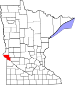
Big Stone County, Minnesota Basics:
Big Stone County Minnesota - Government Site
Population: 5,160
Area: 499 square miles
County seat: Ortonville
Area code(s) in use: 320
Time zone: CST
High school graduate or higher: 89.9%
Bachelor's degree or higher: 15.4%
Median household income: $45,545
Persons in poverty: 12.9%
Home ownership rate: 79.8%
Mean travel time to work: 17.8 minutes
Adjacent counties:
Grant (SD) Lac Qui Parle Roberts (SD) Stevens Swift Traverse
Places in Big Stone County, Minnesota
Bullock Airport,
Kapaun-Wilson Field Airport,
Ortonville Municipal Airport-Martinson Field,
Shannon Field Airport,
Stanley Field Airport Beardsley Fire Department,
Beardsley Police Department,
Beardsley Village Hall,
Big Stone County Courthouse,
Big Stone County Historical Society Museum,
Big Stone County Sheriffs Office,
Clinton Volunteer Fire Department,
Correll Volunteer Fire Department,
Graceville Ambulance Service,
Graceville City Hall,
Graceville Fire Department,
Graceville Public Library,
Odessa Fire Department,
Ortonville Ambulance Service,
Ortonville City Hall,
Ortonville City Public Library,
Ortonville Fire Department County Ditch Number Eight,
County Ditch Number Eleven,
County Ditch Number Seven,
County Ditch Number Two Lou Point,
Point Welcome,
Salmonson Point,
The Peninsula Akron Cemetery,
Artichoke Baptist Cemetery,
Artichoke Lake Cemetery,
Bailey Cemetery,
Beardsley Cemetery,
Big Stone Baptist Cemetery,
Big Stone Hutterite Colony Cemetery,
Clinton Cemetery,
Eids Cemetery,
Eidskog Cemetery,
Elim Cemetery,
Graceville Cemetery,
Holden Cemetery,
Johnson Family Cemetery,
Lakeside Cemetery,
Lakeside Cemetery,
Long Island Cemetery,
Maple Cemetery,
Midway Cemetery,
Mills Cemetery,
Mound Cemetery,
Odessa Immanuel Lutheran Cemetery,
Odessa Trinity Lutheran Cemetery,
Rest Cemetery,
Saint Mary Cemetery,
Saint Pauli Cemetery,
West Saint Paul Cemetery Artichoke Baptist Church,
Artichoke Lake Church,
Beardsley Methodist Church,
Bethany Church,
Bethlehem Lutheran Church,
Church of Saint John,
Congregational United Church,
Congregational United Church,
Eids Church (historical),
Eidskog Church,
Elim Lutheran Church,
First Assembly of God Church,
First English Lutheran Church,
Good Shepherd Lutheran Church,
Grace Lutheran Church,
Holden Church,
Holy Rosary Church,
Immanuel Church,
Kingdom Hall of Jehovahs Witnesses,
Mount Olive Lutheran Church,
New Life Community Baptist Church,
Saint Mary's Catholic Church,
Saint Pauli Norwegian Evangelical Lutheran Church, Siloah Lutheran Church, Trinity Evangelical Lutheran Church,
Trinity Lutheran Church,
Trinity Lutheran Church,
Trinity Lutheran Church,
United Methodist Church,
United Methodist Church,
Zion Lutheran Church Big Stone Lake Dam,
Holtz Irrigation Pond Dam,
Long Tom Lake Dam Lone Tree Lakebed,
Moonshine Lakebed Hanson Slough,
Karl Slough Clinton Community Clinic,
Essentia Health Holy Trinity - Graceville Clinic and Hospital,
Graceville Health Center,
Northside Medical Center,
Ortonville Area Health Services Ortonville Hospital Artichoke Lake,
Barry Lake,
Bassett Slough,
Bentsen Lake,
Campbell Slough,
Clear Lake,
Cup Lake,
Deep Lake,
East Toqua Lake,
Eli Lake,
Fogarty Lake,
Horseshoe Lake,
Lake Leo,
Lannon Lake,
Larson Lake,
Lindgren Lake,
Long Lake,
Long Tom Lake,
Lysing Lake,
Moulton Lake,
Munnwyler Lake,
Munnwyler Lake,
North Rothwell Lake,
Olson Lake,
Olson Lake,
Otrey Lake,
Peterson Lake,
Smithwicks Lake,
South Rothwell Lake,
Swenson Lake,
Thielke Lake,
Twin Lakes,
Walter Lake,
West Toqua Lake Barry,
Beardsley,
Clinton (historical),
Correll,
Graceville,
Graceville Golf Club,
Johnson,
Lakeshore RV Park,
Odessa,
Ortonville,
Ortonville Golf Course Allen State Wildlife Management Area,
Big Stone Lake Overlook,
Big Stone Lake State Park,
Central Park,
Cliffs Park,
Dismal Swamp State Wildlife Management Area,
Finberg State Wildlife Management Area,
Freed State Wildlife Management Area,
Graceville Historical Marker,
Graceville Wayside Park,
Klages State Wildlife Management Areas,
Lac Qui Parle State Wildlife Management Area,
Lakeside Park,
Lindquist State Wildlife Management Area,
Mallard Hole State Wildlife Management Area,
Nielson Park,
Northside Park,
Ortonville Region Historical Marker,
Otrey State Wildlife Management Area,
Peninsula Park,
Prairie State Wildlife Management Area,
Reisdorph State Wildlife Management Area,
Riverside Park,
Sioux Historic Park,
Skoog State Wildlife Management Area,
State Line - Ortonville Wayside Park,
Taffe State Wildlife Management Area,
Thomson State Wildlife Management Area,
Toqua Lakes Park,
Victor State Wildlife Management Area Artichoke,
Barry,
Beardsley,
Big Stone Colony,
Bonanza Grove,
Cashtown,
Clinton,
Correll,
Foster,
Graceville,
Hilltop Manor Mobile Home Park,
Hilltop Manor Mobile Home Park,
Johnson,
Lagoona Beach,
Odessa,
Ortonville,
Yankeetown Adelaide Post Office (historical),
Artichoke Lake Post Office,
Barry Post Office (historical),
Beardsley Post Office, Bigstone Post Office (historical), Clarksville Post Office (historical),
Clinton Post Office,
Correll Post Office, Custer Post Office (historical),
Foster Post Office (historical),
Graceville Post Office, Hilo Post Office (historical),
Johnson Post Office, Kingsbury Post Office (historical), Lowell Post Office (historical), Maud Post Office (historical),
Odessa Post Office,
Ortonville Post Office, Phillips Post Office (historical), Sardis Post Office (historical), Stepney Post Office (historical)
Big Stone Lake,
Long Tom Lake CGB Elementary School,
Clinton Elementary School,
Clinton Graceville High School,
Fish Creek School (historical),
Hilo School (historical),
Kinney School (historical), Lismore Colony School,
Ortonville High School,
School Number 142,
School Number 21 (historical),
School Number 22 (historical),
School Number 35 (historical),
School Number 37 (historical),
School Number 42 (historical),
School Number 47 (historical),
School Number 48 (historical),
School Number 51 (historical),
School Number 57 (historical),
School Number 58 (historical),
School Number 61 (historical),
School Number 64 (historical),
Trinity Lutheran School,
Trinity Lutheran School Fish Creek,
Little Minnesota River,
Stony Run Dismal Swamp,
Government Slough,
Humpty-dumpty Slough,
Lone Tree Slough,
Sandy Slough,
Sweetwater Lake KBAA-FM (Ortonville),
KDIO-AM (Ortonville),

