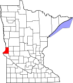
Traverse County, Minnesota Basics:


Traverse County Minnesota - Government Site

Population: 3,443
Area: 574 square miles
County seat: Wheaton
Area code(s) in use: 320 218
Time zone: CST
High school graduate or higher: 89.7%
Bachelor's degree or higher: 16.0%
Median household income: $44,025
Persons in poverty: 9.2%
Home ownership rate: 81.1%
Mean travel time to work: 14.5 minutes


Adjacent counties:
Big Stone  Grant  Richland (ND)  Roberts (SD)  Stevens  Wilkin  

Find in Minnesota

Map of the Traverse County area


Our detail map of Traverse County shows the Traverse County, Minnesota boundary lines and other interesting items.

Places in Traverse County, Minnesota

  Airports     show all on map

Beyer Airport, Frisch Airport, Johnsons Aero Repair Airport, Rick Mathias Private Airport, Simpson Landing Strip, Simpson Landing Strip, Traverse Air Airport, Wheaton Municipal Airport, Zimmerman Airport

  Buildings     show all on map

Browns Valley Ambulance Service, Browns Valley City Hall, Browns Valley Fire Department, Browns Valley Library, Browns Valley Police Department, Dumont Fire Department, Tintah Fire Department, Traverse County Sheriffs Office, Wheaton City Hall, Wheaton Community Library, Wheaton Fire Department, Wheaton Police Department

  Canals     show all on map

County Ditch Number Eight, County Ditch Number Eighteen, County Ditch Number Eleven, County Ditch Number Eleven, County Ditch Number Fifteen, County Ditch Number Fiftyone, County Ditch Number Fiftyone, County Ditch Number Fiftythree, County Ditch Number Fiftytwo, County Ditch Number Forty, County Ditch Number Fortyfour, County Ditch Number Fortyone, County Ditch Number Fortythree, County Ditch Number Fortytwo, County Ditch Number Four, County Ditch Number Four, County Ditch Number Nine, County Ditch Number Ninteen, County Ditch Number One, County Ditch Number One, County Ditch Number Seven, County Ditch Number Seventeen, County Ditch Number Sixteen, County Ditch Number Ten, County Ditch Number Thirteen, County Ditch Number Thirty, County Ditch Number Thirtyeight, County Ditch Number Thirtyfive, County Ditch Number Thirtyone, County Ditch Number Thirtyseven, County Ditch Number Thirtysix, County Ditch Number Thirtythree, County Ditch Number Twenty, County Ditch Number Twentyeight, County Ditch Number Twentyfour, County Ditch Number Twentynine, County Ditch Number Twentysix, County Ditch Number Twentythree, County Ditch Number Two, County Drain Number Twentyseven, Judicial Ditch Number Four, Judicial Ditch Number Seven, Judicial Ditch Number Twelve, Mustinka River Ditch

  Cemeteries     show all on map

Immanuel Cemetery, Lake View Cemetery, Monson Cemetery, Nelson Cemetery, Plateau Cemetery, Pleasant Hill Cemetery, Saint Galls Cemetery, Saint Johns Cemetery, Saint Patrick Cemetery, Sharon Cemetery, Siloah Cemetery, Trinity Cemetery, Valley View Cemetery, Wildwood Cemetery, Zion Cemetery, Zion Cemetery

  Channels     show all on map

Old Channel

  Churches     show all on map

Ave Maria Catholic Church, Bethlehem Covenant Church, Bethlehem Lutheran Church, Browns Valley Catholic Church, Calvary Worship Center, First Congregational Church, Good Shepherd Lutheran Church, Immanuel Church, Immanuel Lutheran Church, Kingdom Hall of Jehovahs Witnesses, Presbyterian Church, Saint Gall's Catholic Church, Saint John Lutheran Church, Saint John's Lutheran Church, Saint Pauls Church, Saint Peters Church, Siloah Church, Taylor Church, Trinity Church, United Methodist Presbyterian Church, Zion Lutheran Church

  Dams     show all on map

Browns Valley Dike, Reservation Highway Dam, White Rock Dam

  Hospitals     show all on map

Browns Valley Clinic, Browns Valley Nursing Home, Sanford Wheaton Medical Center, Traverse Care Center, Wheaton Community Health Center

  Islands     show all on map

Rainbow Island

  Lakes     show all on map

Saint Marys Lake

  Locales     show all on map

Browns Valley, Charlesville (historical), Collis (historical), Dumont (historical), Larsens Camp, Tintah, Wheaton (historical), Wheaton Country Club

  Parks     show all on map

Browns Valley Man Historical Marker, Browns Valley Wayside Park, Continental Divide Historical Marker, Foley State Wildlife Management Area, Reservation Dam State Wildlife Management Ar, Sam Brown Memorial Park, Samuel J Brown State Monument, Wadsworth Trail Historical Marker, White Rock Dam State Wildlife Management Area

  Populated Places     show all on map

Bergs Mobile Home Park, Boisberg, Browns Valley, Charlesville, Collis, Dakomin, Dumont, Schultz Trailer Park, Tintah, Wheaton

  Post Offices     show all on map

Barker Post Office (historical), Browns Valley Post Office, Collis Post Office (historical), Dakomin Post Office (historical), Dumont Post Office, Felix Post Office (historical), Inver Post Office (historical), Leonardville Post Office (historical), Mandada Post Office (historical), Monson Post Office (historical), Pioneer Post Office (historical), Pleasant Hill Post Office (historical), Territtin Post Office (historical), Tintah Post Office, Traverse Post Office (historical), Wheaton Post Office

  Reservoirs     show all on map

Lake Traverse, Mud Lake

  Schools     show all on map

Avery School (historical), Browns Valley Middle School, Bruce School (historical), Four Corner School (historical), Golden Rule School (historical), JE Pearson Elementary School, Lincoln School (historical), Round Mound School (historical), School Number 10 (historical), School Number 13 (historical), School Number 14 (historical), School Number 15 (historical), School Number 16 (historical), School Number 17 (historical), School Number 18 (historical), School Number 2 (historical), School Number 21 (historical), School Number 23 (historical), School Number 25 (historical), School Number 26 (historical), School Number 27 (historical), School Number 28 (historical), School Number 29 (historical), School Number 34 (historical), School Number 37 (historical), School Number 38 (historical), School Number 39 (historical), School Number 40 (historical), School Number 41 (historical), School Number 42 (historical), School Number 43 (historical), School Number 44 (historical), School Number 45 (historical), School Number 46 (historical), School Number 47 (historical), School Number 48 (historical), School Number 49 (historical), School Number 50 (historical), School Number 51 (historical), School Number 52 (historical), School Number 53 (historical), School Number 54 (historical), School Number 55 (historical), School Number 57 (historical), School Number 6 (historical), School Number 60 (historical), School Number 7 (historical), Theake School (historical), Trinity School (historical), Twingrove School (historical), Wheaton High School, Wyman School (historical)

  Streams     show all on map

East Fork Twelvemile Creek, Eighteenmile Creek, Fivemile Creek, Mustinka River, Steer Creek, Twelvemile Creek, West Branch Twelvemile Creek, West Fork Twelvemile Creek

  Swamps     show all on map

Flood Slough, Wet Lake,

Traverse County, Minnesota Population By Race (2012 estimate)

RacePopulation
WhiteTraverse County White population 3,2233,222  
American IndianTraverse County American Indian population 145144
MixedTraverse County Mixed population 4848
BlackTraverse County Black population 1717
Hawaiian & Pacific IslanderTraverse County Hawaiian & Pacific Islander population 76
AsianTraverse County Asian population 33

Additional population tables :
State population table
Minnesota population by county