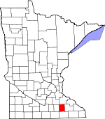
Dodge County, Minnesota Basics:
Dodge County Minnesota - Government Site
Population: 20,234
Area: 439 square miles
County seat: Mantorville
Area code(s) in use: 507
Time zone: CST
High school graduate or higher: 91.7%
Bachelor's degree or higher: 22.0%
Median household income: $66,959
Persons in poverty: 7.3%
Home ownership rate: 86.2%
Mean travel time to work: 23.3 minutes
Adjacent counties:
Freeborn Goodhue Mower Olmsted Rice Steele
Places in Dodge County, Minnesota
Dodge Center Airport Tucker Bridge Claremont City Hall,
Claremont Fire Department,
Dodge Center Ambulance Service,
Dodge Center Fire Department,
Dodge Center Library,
Dodge Center Police Department,
Dodge County Courthouse,
Dodge County Historical Society Library,
Dodge County Sheriffs Office,
Fairview Nursing Home,
Hayfield Community Ambulance,
Hayfield Fire Department,
Hayfield Library,
Kasson Fire Department,
Kasson Police Department,
Kasson Public Library,
Mantorville City Hall,
Mantorville Fire Department,
Mantorville Police Department,
Oslo City Hall,
Oslo City Police Department,
Oslo Fire Hall,
West Concord City Hall,
West Concord Fire Department,
West Concord Library,
West Concord Police Department County Ditch Number Five,
Green Valley Ditch,
Judicial Ditch Number One,
Judicial Ditch Number Seven,
Westfield-Ripley Ditch Ashland-Ripley Cemetery,
Bern Cemetery,
Claremont Street Cemetery,
Concord Cemetery,
Evergreen Cemetery,
Fairview Cemetery,
First Lutheran Cemetery,
Hillside Cemetery,
Maple Grove Cemetery,
Milton Cemetery,
Rice Lake Cemetery,
Riverside Cemetery,
Riverside Cemetery,
Saint Margaret Cemetery,
Saint Vincent de Paul Cemetery,
West Saint Olaf Cemetery,
Westfield Cemetery,
Wildwood Cemetery Assembly of God Church,
Bethel Baptist Church,
Cedar Creek Church,
Concord Church of Christ,
Congregational Church,
Faith Lutheran Church,
First Baptist Church,
First Baptist Church,
First Congregational Church,
First Presbyterian Church,
Grace Lutheran Church,
Holy Family Catholic Church,
Mount Sion Independent Lutheran Church,
Our Savior Evangelical Lutheran Church,
Our Saviour Evangelical Lutheran Church,
Peace Lutheran Church,
Pleasant Corners Church,
Praise Fellowship Church,
Presbyterian Church,
Presbyterian Church,
Rice Lake Church,
Sacred Heart Church,
Saint John's Lutheran Church,
Saint Johns Catholic Church,
Saint Joseph's Church,
Saint Peter's Episcopal Church,
Seventh Day Adventist Church,
The Church of Jesus Christ of Latter Day Saints,
Trinity Lutheran Church,
Trinity Lutheran Church,
United Methodist Church,
West Concord Catholic Church,
West Saint Olaf Church,
Westfield Church,
Zion Lutheran Church, Zwingli Congregational Church
Alberts-Rueg Group Dam,
Jim Donaldson Pond Dam,
Mantorville Dam,
Walter Buehler Detention Dam Field Crest Care Center,
Hayfield Spine Care Center,
Kasson Mayo Family Practice Center Beaver Farms,
Claremont,
Dodge Center,
Double B Farms,
Hayfield (historical),
Kasson,
Mantorville (historical),
Turner Farm,
Walter and Ester Stussy Memorial RV Park,
Wasioja (historical),
West Concord,
Zumbro Ridge Farms Mantorville Retaining Walls Park,
Schletty State Wildlife Management Area,
Wasioja Seminary Historical Marker Berne,
Claremont,
Claremont Mobile Homes,
Concord,
Dodge Center,
Eden,
Fryers Mobile Home Park,
Hayfield,
Heritage Estates,
Kasson,
Mantorville,
Oslo,
Poolers Mobile Home Park,
South Fork Homes,
Southside Mobile Home Park,
Valley View Park,
Vernon,
Vlasaty,
Wasioja,
West Concord,
West Gate Mobile Home Park,
Westfield Center (historical),
Windsor Court Mobile Home Community Ashland Post Office (historical), Avon Post Office (historical),
Berne Post Office (historical), Canesteo Post Office (historical), Cheney Post Office (historical),
Claremont Post Office,
Concord Post Office (historical),
Dodge Center Post Office, East Claremont Post Office (historical), Ellington Post Office (historical), Hallowell Post Office (historical),
Hayfield Post Office, Hector Post Office (historical),
Kasson Post Office,
Mantorville Post Office, Milton Post Office (historical),
Oslo Post Office (historical), Ricelake Post Office (historical), Sacramento Post Office (historical), Thoe Post Office (historical), Union Spring Post Office (historical), Venture Post Office (historical),
Vernon Post Office (historical),
Vlasaty Post Office (historical),
Wasioja Post Office (historical),
West Concord Post Office,
Westfield Centre Post Office (historical) Zumbro River Reservoir Hayfield High School,
Kasson-Mantorville Elementary School,
Kasson-Mantorville Senior High,
Mantorville Intermediate School,
Maranatha Adventist School,
Triton High School,
Triton Intermediate School,
West Concord Elementary School Dodge Center Creek,
Harkcom Creek,
Henslin Creek,
Little Cedar River,
Masten Creek,
Milliken Creek,
Tompkins Creek KRCH-FM (Rochester),

