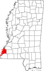
Adams County, Mississippi Basics:


Adams County Mississippi - Government Site

Population: 32,145
Area: 462 square miles
County seat: Natchez
Area code(s) in use: 601
Time zone: CST
High school graduate or higher: 79.5%
Bachelor's degree or higher: 17.6%
Median household income: $27,486
Persons in poverty: 28.6%
Home ownership rate: 68.1%
Mean travel time to work: 19.9 minutes


Adjacent counties:
Concordia (LA)  Franklin  Jefferson  Tensas (LA)  Wilkinson  
Find in Mississippi

Map of the Adams County area


Our detail map of Adams County shows the Adams County, Mississippi boundary lines and other interesting items.

Places in Adams County, Mississippi

  Airports     show all on map

Hardy-Anders Field Natchez-Adams County Airport

  Bars     show all on map

Carthage Upper Bar, Natchez Island Bar

  Bends     show all on map

Dead Mans Bend, Dead Mans Bend, Fairchilds Bend, Giles Bend, Marengo Bend, Saint Catherine Bend

  Bridges     show all on map

Natchez-Vidalia Bridge

  Buildings     show all on map

Adams County Correctional Facility, Adams County Courthouse, City of Natchez Fire Department Station 1 Central Station, City of Natchez Fire Department Station 2, City of Natchez Fire Department Station 3, City of Natchez Fire Department Station 4, Fords Point Post Light, Foster Mound Volunteer Fire Department, Kingston Volunteer Fire Department, Lake Montrose Volunteer Fire Department, Liberty Road Volunteer Fire Department, Quitman Bluff Post Light, Robson Post Light

  Canals     show all on map

Little Canal

  Capes     show all on map

Carthage Point, Cowpen Point, Glasscock Point, Jackson Point

  Cemeteries     show all on map

Adams Cemetery, Barland Cemetery, Blake Cemetery, Brandon Cemetery, Bryandale Cemetery, Buckles Cemetery, Calvin Smith Cemetery, Carter Cemetery, Clemont Cemetery, Collins Cemetery, Cory Cemetery, Dunbarton Cemetery, Evans Cemetery, Farrar Cemetery, Forest Cemetery, Foster Cemetery, Foster Cemetery, Foster Cemetery, Foster Mound Cemetery, Green Lawn Memorial Park, Higgland Cemetery, Hoggatt Cemetery, Holmes Cemetery, King Cemetery, Kingston Cemetery, Linwood Cemetery, McCouen Cemetery, McCoy Cemetery, Mount Olive Cemetery, Natchez City Cemetery, Natchez National Cemetery, Painters Cemetery, Pine Hill Memorial Park, Rawlings Cemetery, Roaring Dale Cemetery, Roseland Cemetery, Routh Cemetery, Rucker Cemetery, Saint Marks Cemetery, Sargent Cemetery, Sessions Cemetery, Sessions Cemetery, Skinners Cemetery, Surget Cemetery, Sweet Auburn Cemetery, Tate Cemetery, Trinity Cemetery, Winston Cemetery

  Census     show all on map

Cloverdale Census Designated Place, Morgantown Census Designated Place

  Channels     show all on map

Giles Cutoff, Glasscock Cutoff, Homochitto Cutoff, Water Proof Cutoff

  Churches     show all on map

Antioch Baptist Church, Assumption Church, Bethel Church, Bethel Church, Beulah Baptist Church, Briel Avenue Baptist Church, Bright Morning Star Church, Calvary Church, Carmel Church, Cedar Grove Church, China Grove Baptist Church, Church of Christ, Church of Christ, Clermont Church, Cliff Temple Church, Clover Hill Church, Cloverdale Baptist Church, Community Chapel Church of God, Cranfield Church, Daughters of Zion Church, Ebenezer Baptist Church, Eqypt Baptist Church, Faith Tabernacle Church, Fatherland Church, First Baptist Church, First Church of the Nazarene, First Presbyterian Church, Forest Aid Church, Friendship Church, Grace United Methodist Church, Greater Fatherland Baptist Church, Greater Mount Sinai Baptist Church, Greater New Bethlehem Baptist Church, Greater New Zion Baptist Church, Grove African Methodist Episcopal Church, Highland Church (historical), Holy Family Catholic Church, Immanuel Baptist Church, Indian Village Church, Jefferson Street United Methodist Church, Jerusalem Baptist Church, Jerusalem Church, King Solomon Baptist Church, Kingston Church, LaGrange Church, Macedonia Baptist Church, Marble Stone Church, Mercy Seat Church, Milford Church, Morgantown Baptist Church, Morning Pilgrim Church, Morning Star Church, Mount Bethel Church, Mount Bethel Church, Mount Bruin Church, Mount Cannan Church (historical), Mount Nebo Baptist Church, Mount Olive Church, Mount Pilgrim Church, Mount Plain Church, Murrays Temple Church of God, New Hope Church, New Hope Church, New Hope Church, New Zion Baptist Church, Parkway Baptist Church, Pentecostal Church of God in Christ, Pilgrim Church, Pine Grove Church, Pine Mount Church, Pine Ridge Presbyterian Church, Pleasant Green Baptist Church, Providence Missionary Baptist Church, Prys Temple, Riverside Church, Robinson Chapel, Rose Hill Baptist Church, Saint Charles Church, Saint James Church, Saint James Church, Saint James Church, Saint Johns Church, Saint Johns Church, Saint Luke Church, Saint Luke Church (historical), Saint Marks Church, Saint Marks Church, Saint Marys Cathedral, Saint Marys Church, Saint Peter Rock Number 1 Church, Saint Peter Rock Number 1 Church, Saint Peter Rock Number 2 Church, Saint Peter Rock Number 2 Church, Saint Peters Baptist Church, Saint Peters Church Number 1, Saint Peters Church Number 2, Salem Church, Shiloh Baptist Church, Sinai Church, Southern Hills Baptist Church, Southwood Church, Springfield Church, Stanton Baptist Church, Stanton Church, Tabernacle of Prayer Church, Tate Magnolia Church, Trace City Baptist Church, Trinity Episcopal Church, United Baptist Church, Washington Baptist Church, Washington United Methodist Church, West Side Baptist Church, Wilderness Church, Windy Hill Number 1 Church, Windy Hill Number 2 Church, Zion Chapel African Methodist Episcopal Church, Zion Hill Church, Zion Watch Church

  Cliffs     show all on map

Ellis Cliffs

  Crossings     show all on map

Holmesberry Ferry (historical)

  Dams     show all on map

Armstrong Lake Dam, Callon Lake Dam, Callon Lake Dam, Callon Lake Dam, Carl Anderson Lake Dam, D C Barksdale Lake Dam, Frank Junkin Lake Dam, Hutchins Creek Dam, Junkin Gravel Company Lake Dam, Kaiser-Carlton Lake Dam, L J Denny Lake Dam, Mrs Roland Stacy Lake Dam, Pipes Lake Dam, Risher Lake Dam, Robbins Lake Dam, Second Creek Structure 10b Dam, Second Creek Structure 11 Dam, Second Creek Structure 12 Dam, Second Creek Structure 7 Dam, Second Creek Structure 8 Dam, Second Creek Structure 9 Dam, Second Creek Watershed Structure 6a Dam, Second Creek Watershed Structure 6b Dam, Second Creek Watershed Structure One Dam, Southwood Lodge Lake Dam, T K Armstrong Catfish Ponds Dam, Tully Seale Lake Dam, Webb Carter Junior Lake Dam, Webb Carter Junior Lake Dam

  Flats     show all on map

Natchez Coravel Pits

  Guts     show all on map

Dies Slough

  Hospitals     show all on map

Charity Hospital, Natchez Community Hospital, Natchez Regional Medical Center

  Islands     show all on map

Fairchilds Island Number 114, Glasscock Towhead, Mercer Island, Middle Ground, Natchez Island

  Lakes     show all on map

Blue Hole, Briars Chute, Butler Lake, Delta Lake, Fields Lake, Flat Lake, Forked Lake, Gaillards Lake, Long Lake, Long Lake, Marengo Lake, Otter Lake, Pipe Lake, Thornburg Lake

  Levees     show all on map

Carthage Revetment, Natchez Front Revetment, Natchez Island Revetment (historical)

  Locales     show all on map

Alloway Landing, Beverly Plantation (historical), Briar Landing, Briers (historical), Carthage Landing, Cerro Gordo Landing, Cowpen Point Landing, Destruction Landing (historical), Dunkerron Plantation (historical), Elms Court Plantation (historical), Englewood Plantation (historical), Eureka Landing, Ford Landing (historical), Gaines Landing (historical), Giles Landing, Glenburny Plantation (historical), Glester Plantation (historical), Jackson Point Landing, Kienstra Landing, Liberty Shopping Center, Longwood Plantation (historical), Magnolia Mall Shopping Center, Majores Plantation (historical), Milo Landing (historical), Morrisana Plantation (historical), Natchez Country Club, Natchez-Adams County Port, Palmetto Plantation (historical), Pandella Landing, Parker Landing, Providence Plantation (historical), Quitmans Landing (historical), Selsertown (historical), Trace Town Shopping Center, Washington Station (historical), Waverly Place Landing

  Military     show all on map

Fort Dearborn (historical)

  Oilfields     show all on map

Alloway Oil Field, Anchorage Oil Field, Anna Oil Field, Armstrong Oil Field, Arnot Oil Field, Beaver Branch Oil Field, Belwood Oil Field, Beverly Oil Field, Bisland Bayou Oil Field, Bourbon Oil Field, Buckhurst Oil Field, Butler Lake Oil Field, Carthage Point Oil Field, Clifford Oil Field, Cloverdale Oil Field, Coles Creek Oil Field, Commencement Oil Field, Cooper Hill Oil Field, Cotton Valley Oil Field, Courtland Oil Field, Cowpen Point Oil Field, Cranfield Oil and Gas Field, Deerfield Oil Field, East Carthage Point Oil Field, East Commencement Oil Field, East Fairview Oil Field, Edgewood Oil Field, Ellis Cliffs Oil Field, Fairchilds Creek Oil Field, Fenwick Oil Field, Flat Lake Oil Field, Forest Home Oil Field, Galilee Oil Field, Gardens Oil Field, Giles Bend Oil Field, Gilliard Lake Oil Field, Glasscock Island Oil Field, Glasscock Oil Field, Glasscock Towhead Oil Field, Glen Aubin Oil Field, Glendale Oil Field, Grafton Oil Field, Greens Bayou Oil Field, Hilo Oil Field, Homewood Oil Field, Hutchins Landing Oil Field, Ivanhoe Oil Field, Jeannette Oil Field, Kingston Oil Field, Lagrange Oil Field, Lake Lucille Oil Field, Laurel Hill Oil Field, Levees Oil Field, Linwood Oil Field, Locust Hill Oil Field, Long Lake Oil Field, Magnolia Oil Field, Majorca Oil Field, Mandamus Oil Field, Mantua Oil Field, Mercer Oil Field, Mistletoe Oil Field, Moorland Oil Field, Morgantown Oil Field, Moss Grove Oil Field, Moss Hill Oil Field, Natchez Ferry Oil Field, New Era Oil Field, North Carthage Point Oil Field, North Cowpen Point Oil Field, North Esperance Oil Field, North Gardens Oil Field, North Kingston Oil Field, North Lagrange Oil Field, North Lake Lucille Oil Field, North Lake Mary Oil Field, North Natchez Oil Field, North Overton Oil Field, North Pelucid Bayou Oil Field, Oakland Oil Field, Ogden Bayou Oil Field, Otter Lake Oil Field, Overton Oil Field, Painters Oil Field, Pellucid Bayou Oil Field, Pine Mount Oil Field, Pleasant Hill Oil Field, Poplar Grove Oil Field, Pretty Creek Oil Field, Quitman Bayou Oil Field, Robbins Bayou Oil Field, Shieldsboro Oil Field, Sibley Oil Field, South Deerfield Oil Field, South Glen Aubin Oil Field, South Jeannette Oil Field, South Kingston Oil Field, South Lagrange Oil Field, South Sammy Creek Oil Field, Southeast Ellislie Oil Field, Southeast Fairview Oil Field, Southeast Moss Hill Oil Field, Southeast Woodlands Oil Field, Southwest Cranfield Oil Field, Southwood Oil Field, Spring Pond Oil Field, Springfield Oil Field, Stanton Oil Field, Vernon Oil Field, Washout Bayou Oil Field, Wayside Oil Field, West Carthage Point Oil Field, West Deerfield Oil Field, West Fairchilds Creek Oil Field, West Locust Hill Oil Field, West Pine Ridge Oil Field, Whites Creek Oil Field, Willow Glen Oil Field, Woodlands Oil Field

  Parks     show all on map

Natchez National Historical Park, Natchez State Park, Pipes Lake Recreation Area, Sandy Creek State Creek Wildlife Management Area

  Populated Places     show all on map

Anna, Arnot, Carthage, Cloverdale, Cranfield, Ellis Cliffs, Fenwick, Foster, Hawthorne, Hutchins Landing, Jeannette, Johnsville, Kienstra, Kingston, Leesdale, Linwood, Morgantown, Natchez, Natchez Under the Hill (historical), Pine Ridge, Saint Catherine, Selma, Sibley, Stanton, Washington

  Post Offices     show all on map

Anna Post Office (historical), Natchez Post Office

  Rapidss     show all on map

Little Gulf

  Schools     show all on map

Anchorage High School, Antioch School (historical), Braden School, Brumfield High School, Carpenter Number 1 Elementary School, Cathedral High School, Central School, Cloverdale School (historical), Deer Park School, Elizabeth Female College (historical), Grove School, Holy Family High School, Holy Family School, Jefferson Military College, Kienstra School (historical), Martin Elementary School, Martin Middle School, Milford School (historical), Montebello Elementary School, Montebello Junior High School, Morgantown Elementary School, Morgantown Middle School, Natchez Junior College, Natchez-Adams Vocational Technical School, Overton School, Painters School (historical), Pine Mount School (historical), Pine Ridge School (historical), Poplar Grove School, Price Elementary School, Quitman School (historical), Rowardale School (historical), South Natchez High School, Stanton College (historical), Thompson Middle School, West Elementary School

  Streams     show all on map

Anthony Branch, Bates Creek, Beaver Branch, Becks Bay, Brown Creek, Bullhead Bayou, Callahan Branch, Cane Bayou, Cave Bayou, Cemetery Bayou, Chase Bayou, Coldhill Bayou, Coles Creek, Cypress Bayou, Dunbar Bayou, Eastfield Creek, Greenfield Bayou, Greens Bayou, Hardings Bayou, Hoggatt Branch, Hutchins Creek, Kittering Creek, Languedoc Creek, Levees Creek, Lynn Creek, Mammoth Bayou, Martin Creek, Melvin Bayou, Mills Bayou, Odum Bayou, Ogden Branch, Old Saint Catherine Creek, Pearl Bayou, Pellucid Bayou, Perkins Creek, Pine Mount Bayou, Pretty Creek, Quitman Bayou, Robins Bayou, Rules Branch, Saint Catherine Creek, Sammy Creek, Sandy Bayou, Sandy Branch, Sandy Creek, Saragossa Bayou, Second Creek, Sharp Bayou, Siloam Bayou, Spanish Bayou, Swafford Branch, Tango Bayou, Town Creek, Turkey Creek, Wades Bayou, Walnut Creek, Washout Bayou, West Fork Homochitto River, Whitens Creek, Whites Creek, Whites Creek, Zurhellen Bayou

  Summits     show all on map

Anna Mounds, Emerald Mound, Fatherland Mounds, Foster Mounds, Mantua Mounds, Stowers Mound, Voucherie Mounds

  Swamps     show all on map

Lake Lucile, Willow Lake

  Towers     show all on map

Leesdale Lookout Tower, WMIS-AM (Natchez), WNAT-AM (Natchez), WQNZ-FM (Natchez)

  Trails     show all on map

Natchez Trace National Scenic Trail,

Adams County, Mississippi Population By Race (2012 estimate)

RacePopulation
BlackAdams County Black population 17,26217,261  
WhiteAdams County White population 14,30514,304
MixedAdams County Mixed population 289289
AsianAdams County Asian population 161160
American IndianAdams County American Indian population 129128
Hawaiian & Pacific IslanderAdams County Hawaiian & Pacific Islander population 00

Additional population tables :
State population table
Mississippi population by county