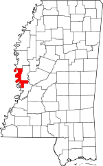
Issaquena County, Mississippi Basics:


Issaquena County Mississippi - Government Site

Population: 1,393
Area: 413 square miles
County seat: Mayersville
Area code(s) in use: 662 601
Time zone: CST
High school graduate or higher: 58.3%
Bachelor's degree or higher: 6.3%
Median household income: $24,474
Persons in poverty: 30.1%
Home ownership rate: 74.2%
Mean travel time to work: 22.2 minutes


Adjacent counties:
Chicot (AR)  East Carroll (LA)  Sharkey  Warren  Washington  Yazoo  
Find in Mississippi

Map of the Issaquena County area


Our detail map of Issaquena County shows the Issaquena County, Mississippi boundary lines and other interesting items.

Places in Issaquena County, Mississippi

  Airports     show all on map

Heigle Field Airport, Lewis Airport, Wade Airport

  Areas     show all on map

Island Number Ninetythree, Pittman Island, Sarah Island

  Bars     show all on map

Ajax Bar, Big Bar, Fitler Bar, Only Bar, Reserve Bar

  Bends     show all on map

Bunches Bend, Fitler Bend

  Buildings     show all on map

Cordell Post Light, Grace Fire Department, Issaquena County Correctional Facility, Issaquena County Courthouse, Mayersville Fire Department, Valley Park Fire Department

  Canals     show all on map

New Valewood Ditch, Steele Bayou Cutoff

  Capes     show all on map

Arcadia Point, Poverty Point

  Channels     show all on map

Lake Providence Reach, Old Channel, Sarah Cutoff

  Churches     show all on map

Bethlehem Church, Christian Home Church, Christian Home Church, Evergreen Church (historical), Friendship Church, Grace Church, Happy Home Church, Mount Aria Church, Mount Edie Church, Mount Sinai Church, Mount Tabor Church, New Bethel Church, Pleasant Green Church, Pleasant Grove Church, Rose Hill Church, Saint James Church, Saint Matthews Church, Saint Pauls Church, Saint Peters Church, Saint Peters Church, Shady Grove Church, Sweet Home Church, Woodland Church

  Crossings     show all on map

Lakeside Ferry (historical)

  Flats     show all on map

Goose Lake Flats

  Gaps     show all on map

Albemarle Crevasse

  Guts     show all on map

Black Bayou, Bunchs Cutoff, Cottonwood Chute, Gross Bayou, Mills Bayou, Muddy Bayou, Old River, Old River Chute

  Islands     show all on map

Cottonwood Bar, Poindexter Island, Stack Island

  Lakes     show all on map

Airplane Lake, Albemarle Lake, Bear Lake, Blue Hole, Blue Hole, Carlisle Lake, Chotard Lake, Cypress Lake, Duck Lake, Fitler Lake, Fivemile Lake, Glory Lake, Goose Lake, Goose Lake, Goose Lake, Greasy Lake, Hardee Lake, Horseshoe Lake, Horseshoe Lake, Kemp Marshall Lake, Little Gassoway Lake, Louisiana Lake, Moon Lake, Moon Lake, Old River, Taylor Lake, Tennessee Lake, Valley Park Lake, Wallace Lake (historical), Whiting Lake

  Levees     show all on map

Cottonwood Revetment, Fitler Revetment

  Locales     show all on map

Albemarle Landing, Arcadia Landing, Baleshed Landing, Bellevue Landing, Ben Lomond Landing, Browns Landing, Burnleys Plantation (historical), Cammacks Landing, Caulfield Plantation (historical), Chotard Landing, Christina Plantation (historical), Christmas Plantation (historical), Cottonwood Landing, Cottonwood Plantation (historical), Dalneys Landing, Dogtail Landing, Duncannon Plantation (historical), Duncansby Landing, Ellislie Plantation (historical), Greasy Bayou Landing, Hay Landing, Holly Ridge Landing, Holly Ridge Plantation (historical), Little Sunflower Landing, McKees Landing, Nelson Plantation (historical), Parks Plantation (historical), Pittman Island Landing, Rosetta Landing, Salem Landing, Shell Mound Landing, Shiloh Landing, Shipland Plantation Landing, Skipwith Landing, Steele Bayou Landing, Tennessee Landing, Wilderness Plantation (historical), Willow Point Landing

  Parks     show all on map

Anderson-Tully State Wildlife Management Area

  Populated Places     show all on map

Adams Landing, Addie, Alexander (historical), Arcadia (historical), Ashland, Booth, Chotard, Elleslie, Fitler, Grace, Hardee, Homochitto (historical), Hopedale, Ingomar (historical), Magna Vista, Mayersville, Millers Landing, New Fitler, Parks Place (historical), Tallula, Valewood, Valley Park

  Post Offices     show all on map

Booth Post Office (historical), Valley Park Post Office

  Ridges     show all on map

Tennessee Bar

  Schools     show all on map

Issaquena School

  Streams     show all on map

Cane Bayou, Cypress Bayou, East Prong Steele Bayou, Indian Bayou, Little Sunflower River, Mound Bayou, Newsom Bayou, Otter Bayou, Steele Bayou, Tillman Bayou, Washington Bayou, Whiting Bayou

  Swamps     show all on map

Alligator Lake, Flag Lake, Lafayette Lake,

Issaquena County, Mississippi Population By Race (2012 estimate)

RacePopulation
BlackIssaquena County Black population 897897  
WhiteIssaquena County White population 482481
American IndianIssaquena County American Indian population 65
MixedIssaquena County Mixed population 11
Hawaiian & Pacific IslanderIssaquena County Hawaiian & Pacific Islander population 00

Additional population tables :
State population table
Mississippi population by county