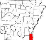
Chicot County, Arkansas Basics:


Chicot County Arkansas - Government Site

Population: 11,443
Area: 644 square miles
County seat: Lake Village
Area code(s) in use: 870
Time zone: CST
High school graduate or higher: 72.5%
Bachelor's degree or higher: 14.2%
Median household income: $25,188
Persons in poverty: 32.3%
Home ownership rate: 67.7%
Mean travel time to work: 21.1 minutes


Adjacent counties:
Ashley  Bolivar (MS)  Desha  Drew  East Carroll (LA)  Issaquena (MS)  Morehouse (LA)  Washington (MS)  West Carroll (LA)  
Find in Arkansas

Map of the Chicot County area


Our detail map of Chicot County shows the Chicot County, Arkansas boundary lines and other interesting items.

Places in Chicot County, Arkansas

  Airports     show all on map

Baker Flying Service Airport, Chicot Memorial Hospital Heliport, Dermott Hospital Heliport, Dermott Municipal Airport, Lake Village Municipal Airport, Ward's Airport

  Areas     show all on map

Howard Island, Island Number 80, Island Number 84, Island Number 86, Island Number 87, Island Number 89, Little Island, Rowdy Bend Towhead

  Bars     show all on map

Leland Bar, Vaucluse Bar

  Basins     show all on map

Panther Forest Crevasse

  Bends     show all on map

Bachelor Bend, Grand Lake Cutoff, Kentucky Bend, Leland Cutoff, Matthews Bend, Miller Bend, Rowdy Bend, Walker Bend

  Buildings     show all on map

Arkansas Department of Corrections Delta Regional Unit, Chicot County Sheriff's Office, Dermott City EMS - Advanced Life Support, Dermott City Hall, Dermott Police Department, Dermott Volunteer Fire Station, Elite Medical Service Chicot County, Elite Medical Services, Eudora City Hall, Eudora Police Department, Eudora Volunteer Fire Station, Fawnwood Volunteer Fire Department, Lake Village Police Department, Lake Village Volunteer Fire Department Station 2, Lake Village Volunteer Fire Station 1, Lakeport Volunteer Fire Department

  Canals     show all on map

Canal Number 2, Canal Number 4, Caney Canal, Diversion Canal Number 1

  Capes     show all on map

Leland Neck, Linwood Neck, Point Chicot

  Cemeteries     show all on map

Anderson Cemetery, Bayou Macon Cemetery, Coleman Cemetery, Davies Cemetery, Davis Cemetery, Greenland Cemetery, Hill Cemetery, Holly Grove Cemetery, Holly Grove Cemetery Number 1, Holly Grove Cemetery Number 2, Jennie Cemetery, Lakeport Cemetery, Liberty Cemetery, Masons Cemetery, McDermott Cemetery, Mount Carmel Cemetery, Mount Zion Cemetery, North Star Cemetery, Old Grange Cemetery, Old Lakeport Cemetery, Pleasant Green Cemetery, Pleasant Grove Cemetery, Pleasant Hope Cemetery, Red Leaf Cemetery, Saint John Cemetery, Saint Luke Cemetery, Tolliver Cemetery, Woodson Temple Cemetery, Yellow Bayou Cemetery

  Channels     show all on map

American Cutoff, Cracraft Chute

  Churches     show all on map

Assembly of God Church (historical), Aulds Church, Bayou Macon Church, Bellaire Church, Bethel Church, Blomey Shay Church (historical), Bloomfield Church, Bloomfield Church (historical), Bright Morning Star Church, Central Church, Chicot Church, Church of God, Crooked Bayou Church, Daughters of Little Rock Church (historical), First Baptist Church, Forrest Aid Church, Freewill Church, Gospel Temple, Grace Church, Greenland Church, Holly Grove Church, Holly Grove Church Number 1, Holly Grove Church Number 2, Holly Ridge Church, Hollywood Church, Jennie Church, Jerusalem Church, King Solomon Church (historical), Lakeport Church, Liberty Church, Midway Church, Midway Church, Morning Star Church, Mount Carmel Church, Mount Holy Church (historical), Mount Pleasant Church, Mount Zion Church, New Bethel Church, New Hope Church, New Hope Church (historical), New Liberty Church, New Mount Zion Church, North Star Church (historical), Oak Grove Church, Omega Church, Pilgrims Rest Church (historical), Pleasant Green Church, Pleasant Grove Church, Pleasant Hope Church, Rising Sun Church, Rising Sun Church (historical), Rose Hill Church, Rossmere Church, Saint James Church, Saint James Church, Saint John Church, Saint Luke Church, Saint Luke Church (historical), Saint Paul Church, Saint Paul Church (historical), Saint Peter Church, Seven Star Church, Smith Chapel, Strangers Rest Church, Sunflower Church, Union Church, Westside Church, Woodson Temple

  Dams     show all on map

Ball Lake Dam Number One, Ball Lake Dam Number Two, Connerly Bayou Pumping Station Dam, Ditch Bayou Station Dam, Lake Chicot Dam North, Paradise Lake Dam, Whiskey Chute Dam

  Guts     show all on map

Bear Bayou, Big Bayou Slough, Connerly Bayou, Ditch Bayou, Fish Bayou, Indian Bayou, Little Lake Bayou, Otter Bayou, Paps Slough, Rush Bayou, Soso Bayou, Swift Bayou

  Hospitals     show all on map

Chicot Memorial Medical Center, Memorial Hospital, Southeast Rehabilitation Hospital

  Islands     show all on map

Archer Island, Bell Island, Cracraft Towhead, Georgetown Towhead, Island Number 81, Island Number 82, Lakeport Towhead, Stuart Island, Worthington Towhead

  Lakes     show all on map

Archer Lake, Beaver Lake, Blue Bayou, Carolina Chute, Cocklebur Lake, Cornfield Chute, Cottonwood Chute, Dry Lake, Duck Lake, Eunice Chute, Grand Lake, Grassy Lake, Lafourche Lake, Lake Boggy Bayou, Lake Chicot, Lake Lee, Lake Paradise, Lake Port, Leland Chute, Long Lake, Macon Lake, Moon Chute, Mud Lake, Muddy Lake, Otter Bayou, Otter Lake, Snag Lake, Swan Pond, Whiskey Chute, Willow Lake, Willow Lake

  Levees     show all on map

American Cutoff Revetment, Cracraft Dikes, Cracraft Lower Dikes, Cracraft Revetment, Grand Lake Revetment, Leland Bar Dikes, Leland Cutoff Revetment, Leland Neck Revetment, Panther Forest Revetment, Spanish Moss Revetment, Sunnyside Revetment, Vacluse Revetment

  Locales     show all on map

Brown Crossing, Carriola Landing, Carter Point Landing, Coal Landing, Cracraft Landing, Dewey Landing, Eunice Landing, Gaines Landing, Grand Lake Landing, Lake Village County Club, Lakeport Landing, Leota Landing, Linwood Landing, Lower Leland Landing, Luna Landing, Mosswood Landing, Panther Forest Landing, Point Comfort Landing, Refuge Landing, Seven Oaks Landing, Sterling Landing, Sunnyside Landing, Vacluse Landing

  Parks     show all on map

Lake Chicot State Park

  Populated Places     show all on map

Albritton (historical), Ashton, Bayou Macon (historical), Bellaire, Boeuf, Bowman, Chanticleer, Chicot, Chicot Junction, Constance (historical), Cosgrove, Decker (historical), Deep Elm, Dermott, Dewey, Elmwood, Eminence, Empire, Eudora, Fairview, Grand Lake, Gum Corner, Halley Junction, Hanna, Harwood, Hickory Ridge, Hudspeth, Hurds, Indian, Jennie, Kaplin (historical), Lake Village, Lakehall, Lakeport, Leland, Luna, Macon Lake, Maxey (historical), McMillan Corner, Myrtle Grove, Panther Forest, Point Comfort, Readland, Red Leaf, Reeves (historical), Ross Van Ness, Scaife (historical), Shives, Sterling (historical), Sunnyside, Vaucluse, Vinson (historical), Wellford, Yellow Bayou

  Post Offices     show all on map

Eudora Post Office, Readland Post Office (historical)

  Reservoirs     show all on map

Ball Lake, Ball Lake, Lake Chicot, Lake Paradise, Whiskey Chute Reservoir

  Schools     show all on map

Bellaire Academy, Central Elementary School, Central Middle School, Dermott Elementary School, Dermott High School, Dermott Middle School, Dermott Upper Elementary School, Eudora High School, Eudora Junior High School, G C Johns Elementary School, G C Johns Lower Elementary School, Holly School, Lakeside High School, Lakeside Lower Elementary School, Lakeside Middle School, Lakeside Upper Elementary School, Morris-Booker Memorial College, Ross Van Ness School, Scaife School (historical), Sterling School (historical)

  Streams     show all on map

Ash Flat, Big Bayou, Bill Young Bayou, Caney Bayou, Crooked Bayou, Dry Bayou, Dry Bayou, East Boggy Bayou, Eminence Bayou, Ferry Bayou, Hill Bayou, Lafourche Bayou, Lighterwood Bayou, Little Click Bayou, Lost Lake, Old Boeuf River, Old River, Wards Bayou, Weaver Bayou, West Boggy Bayou

  Swamps     show all on map

Hubbard Brake

  Towers     show all on map

KUUZ-FM (Lake Village), KVSA-AM (McGehee), KXSA-AM (Dermott), KXSA-FM (Dermott),

Chicot County, Arkansas Population By Race (2012 estimate)

RacePopulation
BlackChicot County Black population 6,2946,293  
WhiteChicot County White population 4,9554,954
MixedChicot County Mixed population 9291
AsianChicot County Asian population 5757
American IndianChicot County American Indian population 3434
Hawaiian & Pacific IslanderChicot County Hawaiian & Pacific Islander population 00

Additional population tables :
State population table
Arkansas population by county