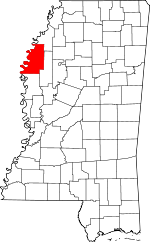
Bolivar County, Mississippi Basics:


Bolivar County Mississippi - Government Site

Population: 34,078
Area: 877 square miles
County seat: Cleveland
Area code(s) in use: 662
Time zone: CST
High school graduate or higher: 73.1%
Bachelor's degree or higher: 20.4%
Median household income: $27,768
Persons in poverty: 34.2%
Home ownership rate: 54.3%
Mean travel time to work: 17.4 minutes


Adjacent counties:
Chicot (AR)  Coahoma  Desha (AR)  Phillips (AR)  Sunflower  Washington  
Find in Mississippi

Map of the Bolivar County area


Our detail map of Bolivar County shows the Bolivar County, Mississippi boundary lines and other interesting items.

Places in Bolivar County, Mississippi

  Airports     show all on map

Bassie Landing Field, Carr Landing Field, Catfish Point Airport, Christmas Airport, Cleveland Municipal Airport, Dorr Field Airport, Glidwell Flying Service Airport, Perthshire Landing Field, Shelby Air Service Airport, Tapley Airport, Watts Field Airport, West Bolivar Flying Service Airport

  Areas     show all on map

Brushy Lake, Catfish Towhead

  Bars     show all on map

Cumbyville Bar, Huntington Bar, Little Red Bar, Lucca Bar, Prentiss Bar, Wood Cottage Bar

  Bends     show all on map

Choctaw Bend, Cypress Bend, Monterey Bend, Rosedale Bend, Yellow Bend

  Bridges     show all on map

South Court Street Bridge

  Buildings     show all on map

Beulah Fire Department, Bolivar County Correctional Facility, Bolivar County Courthouse, Bolivar County Fire Department District 1 Station 1 Cleveland, Bolivar County Fire Department District 1 Station 2 Merigold, Bolivar County Fire Department District 1 Station 3 Pace, Bolivar County Fire Department District 4 Station 1 Gunnison, Bolivar County Fire Department District 4 Station 2 Mound Bayou, Bolivar County Fire Department District 5 Station 1 Shaw, Cleveland Volunteer Fire Department Station 1, Cleveland Volunteer Fire Department Station 2, Rosedale Volunteer Fire Department, Shelby Volunteer Fire Department, Siller Coliseum, Winstonville Volunteer Fire Department

  Canals     show all on map

Bear Pen Canal, Black Bayou Drainage Ditch, Camp Slough Canal, Ditch C, Ditch E, Ditch K, Ditch Number B-2, Ditch Number B-4, Ditch Number C-1, Ditch Number C-1, Ditch Number C-10, Ditch Number C-14, Ditch Number C-3, Ditch Number C-3, Ditch Number C-4, Ditch Number C-5, Ditch Number C-6, Ditch Number C-9, Ditch Number D-2, Ditch Number D-3, Ditch Number D-6, Ditch Number D-8, Ditch Number E-10, Ditch Number E-2, Ditch Number E-3, Ditch Number E-4, Ditch Number E-5, Ditch Number E-5, Ditch Number E-7, Ditch Number Eight, Ditch Number Eight, Ditch Number Eight, Ditch Number Eighteen, Ditch Number Five, Ditch Number Five, Ditch Number Five, Ditch Number Five, Ditch Number Five A, Ditch Number Four, Ditch Number Four, Ditch Number Four, Ditch Number Four, Ditch Number Four, Ditch Number Fourteen, Ditch Number Nine, Ditch Number Nine, Ditch Number Nine, Ditch Number Nine, Ditch Number Nine A, Ditch Number One, Ditch Number One, Ditch Number One, Ditch Number Seven, Ditch Number Seven, Ditch Number Seven, Ditch Number Seven, Ditch Number Seven, Ditch Number Seventeen, Ditch Number Six, Ditch Number Six, Ditch Number Six, Ditch Number Sixteen, Ditch Number Ten, Ditch Number Thirteen, Ditch Number Three, Ditch Number Three, Ditch Number Three, Ditch Number Three, Ditch Number Twelve, Ditch Number Twelve, Ditch Number Twelve A, Ditch Number Twenty, Ditch Number Twentyeight, Ditch Number Twentynine, Ditch Number Twentysix, Ditch Number Two, Ditch Number Two, Holmes Lake Cut-Off

  Capes     show all on map

Catfish Point, Huntington Point, Hurricane Point, Indian Point, Knowlton Point, Smith Point

  Cemeteries     show all on map

Anns Tabernacle Cemetery, Asia Cemetery, Aycock Cemetery, Beaver Cemetery, Bellamy Chapel, Beulah Cemetery, Booker Cemetery, Brown Cemetery, Burrus Cemetery, Chrisman Cemetery, Clark Cemetery, Concordia Cemetery, Dean Ridge Cemetery, Delta Heights Memorial Gardens, Dickerson Cemetery, Egypt Ridge Cemetery, El Bethel Cemetery, Eutaw Cemetery, Fairview Cemetery, German Lane Cemetery, Gunnison Cemetery, Hall Cemetery, Martin Cemetery, Mexican Cemetery, Miles Cemetery, Mount Cazy Cemetery, Mount Evergreen Cemetery, Mount Harmon Cemetery, Mount Olive Cemetery, Mount Olive Cemetery, Mount Zion Cemetery, New Ashley Cemetery, New Cleveland Cemetery, New Hope Cemetery, New Hope Cemetery, New Hope Cemetery, Old Cleveland Cemetery, Old Stone Cemetery, Parthenia Cemetery, Person Cemetery, Peters Rock Cemetery, Pickett Cemetery, Pleasant Grove Cemetery, Polk-Royal Cemetery, Poplar Grove Cemetery, Rosedale Cemetery, Round Lake Cemetery, Saint Joseph Cemetery, Saint Peter Cemetery, Sanders Cemetery, Scotland Cemetery, Scott Cemetery, Sharewell Cemetery, Shelby Cemetery, Smith and Williams Cemetery, Smith Cemetery, Speckter Cemetery, Strangers Rest Cemetery, Turners Chapel Cemetery, Union Temple Cemetery, Waldon Cemetery, Ward Chapel Cemetery, Zion Cemetery

  Channels     show all on map

Victor Cutoff

  Churches     show all on map

Adath Israel Temple, Antioch Church, Antioch Church, Beautiful Star Church, Bellamy Chapel, Bethel Church, Bethlehem Church, Bethlehem Church, Bethlehem Number 1 Church, Bethlehem Number 2 Church, Bold Pilgrim Church, Bold Pilgrim Church, Bradford Chapel, Bright Star Church, Brown Temple, Burken Church (historical), Calvery Church, Chesterfield Church, Damascus Church, Davis Chapel, East Star Church, Ebenezer Church (historical), El Bethel Church, Eldridge Church (historical), Eutaw Church, First Baptist Church, First Independent Methodist Church, First Presbyterian Church, First United Methodist Church, Flower Shepard Church, Gospel Light Church, Gospel Temple, Greengrove Church, Hooper Chapel, Interstate Church, Jacob Church, Jerusalem Church, Jerusalem Church, Jerusalem Church, Johnson Kemper Church, Jordan Grove Church, Joseph Chapel, Kindling Altar Church, King Solomon Church (historical), Lampton Chapel, Little Rock Church, Living Hope Church, Longshot Church, Macedonia Church, Macedonia Church, Macedonia Church, Macedonia Church, Macedonia Church, Macedonia Church (historical), Magnolia Church, Magnolia Church, Mercy Seat Church, Midway Church, Mission Bautista Mexicana, Morning Star Church, Morning Star Church, Morning Star Church, Morrison Chapel Baptist Church, Mount Calvary Church, Mount Evergreen Church (historical), Mount Gazy Church, Mount Harmon Church, Mount Hope Church, Mount Moriah Church, Mount Moriah Church (historical), Mount Olive Church, Mount Olive Church, Mount Olive Church, Mount Olive Church, Mount Olive Church (historical), Mount Olive Church (historical), Mount Pilgrim Church, Mount Pleasant Church, Mount Pleasant Church, Mount Tanya Church, Mount Zion Church, Mount Zion Church, Mount Zion Church (historical), New Ashley Church, New Bethel Church, New Hope Church, New Hope Church, New Hope Church, New Hope Church, New Hope Church, New Hope Church (historical), New Hopewell Church, New Macedonia Church (historical), New Morning Star Church, New Mount Zion Church, New Prospect Church, New Saint James Church, New Salem Church, Niland Chapel, Nugent Church, Old Macedonia Church (historical), Old Mount Olive Church, Our Lady of Victory Catholic Church, Pace Church, Palestine Church, Parks Chapel (historical), Peters Rock Church, Pilgrim Rest Church, Pilgrims Rest Church, Pilgrims Rest Church, Pilgrims Rest Church, Pitts Chapel, Pleasant Green Church, Pleasant Green Church, Pleasant Grove Church, Pleasant Grove Church, Pleasant Grove Church, Pleasant Grove Church, Pleasant Grove Church, Poplar Grove Church, Poplar Grove Church, Providence Church, Rice Chapel, Rising Star Church, Rising Sun Church, Rock of Ages Church, Rock of Ages Church, Rose Hill Church, Saint Andrews Church, Saint Andrews Church, Saint James Church, Saint John Church, Saint John Church, Saint John Church, Saint Johns Church, Saint Luke United Methodist Church, Saint Marys Church (historical), Saint Matthew Church, Saint Paul Church, Saint Paul Missionary Baptist Church, Saint Pauls Church, Saint Pauls Church, Saint Peters Rock Missionary Baptist Church, Saint Philips Church (historical), Saint Thomas Church, Sanders Chapel (historical), Shady Grove Church, Shiloh Church, Shiloh Church (historical), Shipmans Chapel, Silver Mount Church, Spring Hill Church, Springfield Church, Strangers Home Church, Strangers Rest Church, Sunnyside Church, Sunrise Church, Travel Rest Church, Tree of Life Church, Turners Chapel, Union Grove Church, Union Grove Church, Union Hill Church, Union Temple, Virgin Mary Church (historical), Wander Home Church, Ward Chapel, Watson Temple, Waxhaw Church, White Cloud Chapel (historical), White Plains Church, White Star Church, Williams Chapel, Wilnot Chapel (historical), Yale Street Baptist Church, Zion Church, Zion Field Church

  Dams     show all on map

Alford Butler Lake Dam, Allendales Lake Dam, Bob Malone Catfish Ponds Dam, Charles Heinz Catfish Ponds Dam, Cleveland Fisheries Dam, Cleveland Sewage Lagoon Dam, Conservation Lake Dam, Dalton Taylor Catfish Ponds Dam, Ernest Finley Pond Dam, J R Taylor Catfish Ponds Dam, James Maxwell Lake Dam, Judge Brizzell Pond Dam, Merigold Sewage Lagoon Dam, Mike Litton Catfish Ponds Dam, Mills Brothers Catfish Ponds Dam, Mills Brothers Catfish Ponds Dam, Mills Brothers Catfish Ponds Dam, Mississippi Power and Light Pond Dam, Mound Bayou Recreation Lake Dam, Mound Bayou Sewage Lagoon Dam, Mrs Vaught Catfish Ponds Dam, Paul Braswell Catfish Ponds Dam, Rosedale Sewage Lagoon Dam, Shaw Sewage Lagoon Dam, Sutter Pond Dam, Verl Fuller Catfish Ponds Dam

  Forests     show all on map

Interstate Woods

  Guts     show all on map

Buffalo Bayou, Catfish Chute, Concordia Chute, Hog Pen Slough, Pecan Bayou Cutoff, Turkey Pen Bayou, Whiskey Chute, Willow Slough, Willow Slough

  Hospitals     show all on map

Bolivar Medical Center, Shelby Community Hospital

  Islands     show all on map

Concordia Island, Island Number Seventy, Island Number Seventyseven, Mud Island, Ozark Island Number Seventyfive

  Lakes     show all on map

Alligator Lake, Barrows Lake (historical), Beulah Crevasse, Big Blue Hole, Big Monocnoc Lake, Boles Lake, Brushy Lake, Buck Lake, Concordia Bayou, Conservation League Lake, Emory Pond (historical), Holmes Lake, Howden Lake, Island Lake, Kimball Lake, Lake Bolivar, Lake Concordia, Lake Vermilon, Legion Lake, Little Monocnoc Lake, Log Hole, Log Loader Chute, Long Hole, Lost Lake, Lost Lake, McClellan Lake, Mound Crevasse, North Blue Hole, Old River Lake, Old Tar Paper Shack Lake, Pecan Lake, Picnic Hole, Porter Lake, Raineys Lake, Round Hole, Round Lake, Round Lake, Sawgrass Lake (historical), Sikes Blue Hole, Sixmile Lake, Sledge Crevasse, South Blue Hole, Stamps Lake, Swan Lake (historical)

  Levees     show all on map

Cessions Revetment, Choctaw Revetment, Dennis Revetment, Huntington Point Revetment, Riverton Revetment

  Locales     show all on map

Asia Plantation (historical), Bird Landing, Bolivar County Farm, Buckridge Landing, Carsons Landing, Chenault Farms, Cleveland Industrial Park, Cookes Landing (historical), Delta State Golf Course, Dowd Plantation (historical), Eutaw Store (historical), Fallback Plantation (historical), Howarth Farm, Kentucky Landing, Kirks Plantation, Klondike Landing, Lane Landing (historical), Lees Flat, Lower Rosedale Landing, Manocknut Plantation (historical), Matthews Crossing (historical), Melrose Landing (historical), Nebletts Landing (historical), Prentiss Landing, Rosedale Landing, Scotland Plantation (historical), Stop Landing (historical), Sugar Hill Plantation (historical), Timber Lake Plantation (historical), Wildwood Plantation (historical)

  Parks     show all on map

Bear Pen Park, East Side Park, Firemans Park, Firemans Park, Shady Grove Park, Walter Sillers Memorial Park

  Populated Places     show all on map

Alligator, Australia Landing, Benoit, Beulah, Bolivar, Bolivar Landing, Boyle, Busey, Catfish Point Landing, Cessions Landing, Choctaw, Christmas, Cleveland, Cleveland Crossing, Clifford, Concordia, Dahomy, Deeson, Dennis Landing, Dixie, Duncan, Eldridge, Eutaw, Eutaw Landing, Francis, Gill, Grapeland, Gunnison, Hannah, Home Landing, Hushpuckena, Kimball Lake, Lake Vista, Lamont, Laughlin, Litton, Lobdell, Longshot, Malvina, Mason Landing, Meltonia, Merigold, Mound Bayou, Mound City, Mound Landing, Niblett Landing, Niles, O'Reilly, Pace, Perthshire, Prentiss (historical), Renova, Riverton Landing, Rochdale, Rosedale, Round Lake, Scott, Shaw, Shelby, Skene, Stringtown, Symonds, Terrene Landing, Turners Flat, Victor, Waxhaw, Winstonville, Wright, Zumbro

  Post Offices     show all on map

Alligator Post Office (historical), Cleveland Post Office, Clifford Post Office (historical), Dahomy Post Office (historical), Ivy Post Office (historical), Lobdell Post Office (historical), Niles Post Office (historical), O'Reilly Post Office (historical), Perthshire Post Office (historical), Rochdale Post Office (historical), Waxhaw Post Office (historical)

  Reservoirs     show all on map

Grassy Lake

  Ridges     show all on map

Egypt Ridge

  Schools     show all on map

Alligator Elementary School, Anarke School (historical), Bell Elementary School, Benoit High School, Bob Woods Elementary School, Bolivar County Agricultural High School (historical), Bolivar County High School, Bolivar County Junior High School, Booker School (historical), Broad Street High School, Brooks Elementary School, Cleveland Colored Consolidated School (historical), Cleveland High School, Cypress Park Elementary School, Delta State University, East Side High School, Eastwood Junior High School, Germania School (historical), Joe Barnes Vocational Technical Center, John F Kennedy Memorial High School, King Solomon School (historical), Magnolia School (historical), Margaret Green Junior High School, McEvans School, Merigold School, Montgomery Elementary School, Nailor Elementary School, New Hope School (historical), Nugent Center School, Pace Center School, Pace Elementary School, Parks Elementary School, Renova School (historical), Rosedale Normal Industrial College (historical), Shaw High School, Shelby Elementary School, Skene School, Smith School (historical), Switzer School (historical), White Zion School (historical), Woodbine School (historical)

  Streams     show all on map

Alligator Bayou, Ann Bayou, Beaver Bayou, Belman Bayou, Big Bradford Bayou, Black Bayou, Bogue Hasty, Brook Bayou, Browns Bayou, Brushy Bayou, Bull Bayou, Burrus Bayou, Christmas Lake Branch, Concordia Bayou, Concordia Drain, Dry Bayou, Dry Bayou, East Bogue Hasty, East Branch Deer Creek, Edward Bayou, Goffs Bayou, Good Luck Bayou, Grassy Lake, Half Moon Bayou, Henderson Bayou, Hushpuckena River, Icy Bayou, Jones Bayou, Jordan Bayou, Laban Bayou, Lane Bayou, Little Bradford Bayou, Little Mound Bayou, Little Steele Bayou, McNeil Slough, Moon Lake, Mound Bayou, Otter Lake Bayou, Parker Branch, Pecan Bayou, Pecan Bayou, Pistol Slough, Rossin Bayou, Sandy Slough, Silver Bayou, Snake Bayou, Snake Creek, Stillwater Bayou, Stokes Bayou, Stokes Bayou, Straight Bayou, Thousand Yard Bayou, Tommie Bayou, Turn Bayou, Upper Bogue, West Bogue Hasty, Wildcat Slough, Wilkes Bayou, Yellow Bayou

  Swamps     show all on map

Brushy Lake, California Brake (historical), Duck Chute, Merigold Brake, Mud Lake, Picket Lake, Saw Grass Lake, Yankum Lake

  Towers     show all on map

WCLD-AM (Cleveland), WCLD-FM (Cleveland), WQAZ-FM (Cleveland), WRDC-AM (Boyle), WRDC-AM (Cleveland), WXVT-TV (Greenville),

Bolivar County, Mississippi Population By Race (2012 estimate)

RacePopulation
BlackBolivar County Black population 22,08322,082  
WhiteBolivar County White population 11,48411,484
MixedBolivar County Mixed population 204204
American IndianBolivar County American Indian population 6868
Hawaiian & Pacific IslanderBolivar County Hawaiian & Pacific Islander population 3434

Additional population tables :
State population table
Mississippi population by county