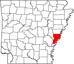
Phillips County, Arkansas Basics:


Phillips County Arkansas - Government Site

Population: 20,789
Area: 696 square miles
County seat: Helena
Area code(s) in use: 870
Time zone: CST
High school graduate or higher: 73.0%
Bachelor's degree or higher: 13.2%
Median household income: $27,219
Persons in poverty: 32.3%
Home ownership rate: 55.9%
Mean travel time to work: 18.6 minutes


Adjacent counties:
Arkansas  Bolivar (MS)  Coahoma (MS)  Desha  Lee  Monroe  Tunica (MS)  
Find in Arkansas

Map of the Phillips County area


Our detail map of Phillips County shows the Phillips County, Arkansas boundary lines and other interesting items.

Places in Phillips County, Arkansas

  Airports     show all on map

Fess Landing Strip, Gibbons Airport, Griffin Ag Airport, Helena Hospital Heliport, Thompson-Robbins Airport, Williams Landing Strip

  Basins     show all on map

Modoc Crevasse

  Bays     show all on map

Modoc Old River

  Bends     show all on map

Francis Bend, Horseshoe Bend, Old Town Bend, Sunflower Bend, Sunflower Cut-Off

  Buildings     show all on map

Arkansas Street Fire Station, Barton Rural Fire Station, Delta Cultural Center, Elaine Police Department, Elaine Volunteer Fire Department, Estevan Hall, Fern Hill Fire Station, Helena City Hall, Helena Fire Department, Helena Police Department, Helena Public Library, Lake View Police Department, Lakeview Fire Department, Lexa Rural Volunteer Fire Department, Marvell Fire Department, Marvell Police Department, Marvell Rural Volunteer Fire Department, Pafford Emergency Medical Services West Helena, Phillips County Community Center, Phillips County Courthouse, Phillips County Museum, Phillips County Sheriff's Office, South Phillips County Volunteer Fire Department Station 2, South Phillips County Volunteer Fire Station 1, Wabash Volunteer Fire Department, Watkins Corner Volunteer Fire Department, West Helena City Hall, West Helena Fire Department, West Helena Police Department, West Helena Public Library

  Canals     show all on map

Beaver Bayou Ditch, Cypress Ditch, Johnson Bayou Ditch, Lateral Number 2

  Capes     show all on map

Coon Point, Jackass Point, Lake Point, Lone Willow Point, Prairie Point, Rock Point, Stumpy Point

  Cemeteries     show all on map

Ashberry Cemetery, Bethel Cemetery, Billingsley Cemetery, Brown Cemetery, Busby Cemetery, Cedar Grove Cemetery, Central Cemetery, Coffee Creek Cemetery, Cooper Cemetery, Friendship Cemetery, Gilbert Hill Cemetery, Gill Cemetery, Hell Cemetery, Honor Hill Cemetery, Jackson Chapel Cemetery, Jones Cemetery, Lightfoot Cemetery, Lone Valley Cemetery, Magnolia Cemetery, Maney Cemetery, Maple Hill Cemetery, Morning Grove Cemetery, Mount Gilean Cemetery, Mount Mariah Cemetery, Mount Olive Cemetery, Mount Olive Cemetery, Mount Olive Cemetery, Mount Pleasant Cemetery, Mount Pleasant Cemetery, Mount Shavery Cemetery, Mount Zion Cemetery, New Jerusalem Cemetery, New Life Cemetery, New Zion Cemetery, O'Shield Cemetery, Oak Grove Garden Cemetery, Odd Fellows Cemetery, Pastel Cemetery, Polly Dots Cemetery, Postelle Cemetery, Rehoboth Cemetery, Rindy Grove Cemetery, Rindy Grove Cemetery, Saint Claire Cemetery, Saint James Cemetery, Saint Johns Cemetery, Saint Johns Cemetery, Saint Marks Cemetery, Saint Marys Cemetery, Saint Pauls Cemetery, Saint Peter Cemetery, Salem Cemetery, Schaffhauser Cemetery, Section Cemetery, Spring Lake Cemetery, Stephens Cemetery, Sunset Memorial Park, Taylor Cemetery, Tucker Grove Cemetery, Turner Cemetery, Wilson Cemetery

  Channels     show all on map

Girard Reach, Helena Reach, Horseshoe Cutoff, Montezuma Cutoff

  Churches     show all on map

Antioch Church, Ashberry Church, Barton Baptist Church, Beach Tree Church (historical), Bee Tree Church (historical), Bethlehem Church, Bethlehem Church, Bethlehem Church, Beulah Church, Blackfoot Church, Brooks Chapel, Brown Chapel, Brown Chapel (historical), Calvary Baptist Church, Calvary Church, Centennial Baptist Church, Central Church (historical), Church of God, Church of God, Church of God (historical), Church of God of Prophecy, Church of the Living God, Connells Point Church, Corder Chapel (historical), Corinth Church, County Line Church, Cypert Church, Elaine Mission, Elizabeth Church, Faith Outreach Ministries, First Assembly of God Church, First Baptist Church, First Baptist Church, First United Methodist Church, Fourth Saint Church, Freedonia Church, Friendship Church, Gumwood Church, Hickory Ridge Church (historical), Hicks Church, Jackson Chapel, Lake View Church, Lambrook Baptist Church, Liberty Church (historical), Little Zion Church, Llewellyn Church (historical), Long Grove Church, Long Lake Church, Macedonia Church, Macedonia Church (historical), Maney Church, Midway Church, Moores Chapel (historical), Morning Grove Church, Morning Star Church, Morning Star Church, Morning Star Church, Morning Star Church, Mount Gilean Church, Mount Lula Church, Mount Mariah Church, Mount Olive Church, Mount Olive Church, Mount Olive Church, Mount Olive Church (historical), Mount Pleasant Church, Mount Pleasant Church, Mount Shavery Church, Mount Zion Church, New Hope Church, New Hope Church, New Hope Church, New Jerusalem Church, New Life Church, New Mount Everett Church, New Zion Church, New Zion Church, Old Jerusalem Church, Old Mount Everett Church, Paradise Church, Pettis Memorial Church, Pilgrim Guide Church, Pilgrims Rest Church, Pleasant Grove Church, Pleasant Hill Church, Pleasant Joy Church, Point Pleasant Church, Precious Chapel, Primitive Church, Rehoboth Church, Saint Claire Church, Saint James Church (historical), Saint John Church, Saint Johns Church, Saint Johns Church, Saint Johns Church (historical), Saint Johns Episcopal Church, Saint Luke Church, Saint Luke Church, Saint Marks Church (historical), Saint Marys Church, Saint Marys Church, Saint Mathews Church, Saint Matthews Church, Saint Pauls Church, Saint Peter Church, Saint Peters Church, Sequell Church, Silver Cloud Church, Spring Lake Church, Spring Lake Church (historical), Springdale Church, Star of Bethlehem Church, True Light Church, Tucker Grove Church, Turner Church, Vanhook Church (historical), Wards Chapel, Watson Temple Church, West Helena Baptist Church, West Helena Church of the Nazarene, West Helena United Methodist Church, Wycamp Missionary Church, Zion Hill Church, Zion Traveler Church

  Cliffs     show all on map

Kangaroo Point

  Dams     show all on map

Heritage Hill Pond Dam, Jakes Lake Dam, Storm Creek Lake Dam

  Guts     show all on map

Beaver Bayou Ditch, Chute of Island, Dixie Bayou, Little Bee Bayou, Long Lake, McGehee Bayou, Sandy Slough

  Hospitals     show all on map

East Arkansas Mental Health Center, Helena Hospital, Helena Regional Medical Center

  Islands     show all on map

Helena Towhead, Island Number 61, Island Number 62, Island Number 64, Island Number 66, Island Number 68, Jug Harris Towhead, Little Island, Montezuma Towhead, Prairie Point Towhead

  Lakes     show all on map

Allen Lake, Beaver Pond, Brushy Lake, Burnt Lake (historical), Cargo Slash, Chaney Lake, Chute of Island 68, Cober Lake, Dustin Pond, Eagle Nest Lake, Flag Lake, Flat Lake, Forked Lake, Hornor Neck, Horseshoe Lake, Jentry Lake, Lacy Lake, Lake Bayou, Little Cypress Lake, Long Lake, Long Lake, Long Lake, Lost Lakes, Lower Taylor Lake, Old Town Lake, Pennyson Lake (historical), Porter Lake, Round Lake, Steelman Lake, Swan Lake, Tupelo Lake, Upper Taylor Lake, Willow Lake, Willow Lake

  Levees     show all on map

Avenue Revetment, Below Ludlow Dikes, Helena Revet, Island Number 62 Revetment, Kangaroo Point Dikes, Lodlow Revetment, Ludlow Revetment, Montezuma Towhead Dikes, Oldtown Bend Revetment, Prairie Point Dikes, Saint Francis Revet, Westover Revetment

  Locales     show all on map

Avenue Landing, Crowley Ridge Overlook, Dawson Landing, Fitzhugh Landing, Helena Casting Field Landing, Helena Country Club, Helena Junction, Houston Landing, Hudsons Landing Campground, Kangaroo Point Landing, Key Store (historical), Ludlow Landing, Mouth of Saint Francis Landing, Neuka Spur (historical), Storm Creek Lake Campground, Storm Creek Lake Campground, Westover Landing, Williamson Landing, Zion Traveler Cemetery

  Military     show all on map

Battery A (historical), Battery B (historical), Battery C (historical), Battery D (historical), Fort Curtis (historical)

  Parks     show all on map

Beech Street Historic District, Cherry Street Historic District, East Park, Eliza Miller Park, Perry Street Historic District, West Park

  Populated Places     show all on map

Barton, Belser (historical), Blackfoot, Catron, Countiss, Crumrod, Cypert, Edgewood, Elaine, Ewal, Fair Landing, Ferguson, Ferguson Landing, Gobell, Harbis (historical), Helena, Helena Crossing, Helena-West Helena, Hicks, Hicksville, Holiday Hills, Hoop Spur, Hugo (historical), Huma, Kindall, Kingtown, Lake Ridge, Lakeview, Lambrook, Latour, Lexa, Lexa Junction, Lundell, Maple Corner, Marvell, Mary Spur, Mellwood, Midland Heights, Modoc, Modoc Landing, Morning Star, Mosby Spur, New Hope (historical), North Creek (historical), North Lexa, Oak Forest, Offutt Landing, Old Town, Oneida, Pilgrims Rest, Pillar, Poplar Grove, Postelle, Preston Place, Ragan, Ratio, Southland, Trenton, Turkey Scratch, Turner, Tyner (historical), Wabash, Walnut Corner, Watkins Corner, West Helena, Westover, Wycamp

  Post Offices     show all on map

Crumrad Post Office, Helena Post Office, Mellwood Post Office, Oneida Post Office, Turner Post Office, Wabash Post Office, West Helena Post Office

  Reservoirs     show all on map

Heritage Hill Pond, Jake Lake, Jakes Lake, Storm Creek Lake

  Schools     show all on map

Barton Elementary School, Barton High School, Beach Tree School (historical), Beech Crest Elementary School, Bethlehem School, C V White High School, C V White High School, Coffee Creek School, Connells Point School (historical), Cypert School (historical), DeSoto Elementary School, DeSoto High School, District 44 School (historical), Elaine High School, Fitzhugh School (historical), Freederia School (historical), Good Luck School, Gumbottom School, Helena Crossing Elementary School, Helena-West Helena Central High School, Hicks School (historical), J F Wahl Elementary School, Jefferson Elementary School, King David School (historical), Lake View Elementary School, Lakeview Elementary School, Little Zion School (historical), Llewellyn School (historical), Long Lake School (historical), Lucilia Wood Elementary School, Lucilla Ward Elementary School, Marvell Academy, Marvell Elementary School, Marvell High School, Marvell Middle School, Marvell Primary School, Mellwood School (historical), Miller Junior High School, Morning Star School, Mosby Spur School (historical), Mount Olive School (historical), Mount Pleasant School (historical), Mount Zion School (historical), New Zion School (historical), Northend School, Oneida Junior High School, Paradise School (historical), Phillips County Community College, Pillar School (historical), Pleasant Joy School (historical), Ratio School (historical), Rollingwall School, Saint Luke School, Saint Marys School, Saint Stephens School (historical), Salem School (historical), Stephens School (historical), Turner School, Union School (historical), Union School (historical), United States National River Academy, Walters Southland Institute, West Side Elementary School, Woodruff Elementary School, Woodsdale School (historical)

  Springs     show all on map

Big Spring

  Streams     show all on map

Bear Bayou, Bear Bayou, Bee Bayou, Bee Bayou, Big Creek, Big Cypress Creek, Big Sandy Bayou, Caney Creek, Coffee Creek, Cottonwood Slough, Crooked Creek, Crooked Creek, Cypress Bayou, Gauzley Bayou, Govan Slough, Humphrey Slough, Jessie Slough, Lick Creek, Little Cypress Creek, Little Island Bayou, Middle Bayou, Mill Fork, Missouri Slough, North Creek, North Fork Bee Bayou, Oak Bayou, Porter Bayou, Saint Francis River, Sandy Branch, Scrubgrass Bayou, South Fork Bee Bayou, Storm Creek, Westover Bayou, Yellow Bank Bayou

  Swamps     show all on map

Cypress Swamp, Hubbard Lake

  Towers     show all on map

KCLT-FM (West Helena), KCRI-FM (Helena), KFFA-AM (Helena), KJIW-AM (West Helena), KJIW-FM (Helena),

Phillips County, Arkansas Population By Race (2012 estimate)

RacePopulation
BlackPhillips County Black population 12,99312,993  
WhitePhillips County White population 7,4637,463
MixedPhillips County Mixed population 187187
American IndianPhillips County American Indian population 6262
Hawaiian & Pacific IslanderPhillips County Hawaiian & Pacific Islander population 00

Additional population tables :
State population table
Arkansas population by county