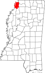
Tunica County, Mississippi Basics:


Tunica County Mississippi - Government Site

Population: 10,510
Area: 455 square miles
County seat: Tunica
Area code(s) in use: 662
Time zone: CST
High school graduate or higher: 73.7%
Bachelor's degree or higher: 14.5%
Median household income: $30,463
Persons in poverty: 30.3%
Home ownership rate: 46.1%
Mean travel time to work: 18.9 minutes


Adjacent counties:
Coahoma  Crittenden (AR)  Desoto  Lee (AR)  Panola  Phillips (AR)  Quitman  Tate  
Find in Mississippi

Map of the Tunica County area


Our detail map of Tunica County shows the Tunica County, Mississippi boundary lines and other interesting items.

Places in Tunica County, Mississippi

  Airports     show all on map

Arnold Field Airport, Ralph M Sharpe Airport, Tunica Municipal Airport

  Areas     show all on map

Clark Towhead, Mac Towhead

  Bars     show all on map

Austin Bar, Buck Island Bar, Dupuy Bar, Flower Lake Bar, Shoo Fly Bar

  Bends     show all on map

Council Bend, Fox Island Bend, Old Walnut Bend, Saint Francis Bend, Ship Island Bend, Walnut Bend

  Buildings     show all on map

North Tunica County Fire and Rescue Department, Tunica Fire Department

  Canals     show all on map

Big Six Ditch, Coon Bayou Cut-Off, Ditch Number Eight, Hollywood Brake, Indian Creek Bayou

  Capes     show all on map

Blue Point, Bordeaux Point, Bowies Point, Dales Point, Halbert Point, Harbert Point, Trotters Point

  Cemeteries     show all on map

Belmont Cemetery, Berea Cemetery, Bethany Cemetery, Bethlehem Cemetery, Bosket Cemetery, Bradley Cemetery, Church of God Cemetery, Clear Lake Cemetery, Corinth Cemetery, Crouse Cemetery, Crystal Springs Cemetery, Daygo Cemetery, Dooley Wood Cemetery, Dowd Cemetery, Forestdale Cemetery, Fredonia Cemetery, Friendship Cemetery, Johnson Chapel Cemetery, Kyles Cemetery, Macedonia Cemetery, Morning Star Cemetery, Mount Nebo Cemetery, Mount Olive Cemetery, Mount Olive Cemetery, Mount Sinia Cemetery, New Baptist Cemetery, New Hope Cemetery, Oak Grove Cemetery, Oakwood Cemetery, Phillips Cemetery, Pilgrim Rest Cemetery, Pleasant Ridge Cemetery, Rainey Cemetery, Rising Sun Cemetery, Saint Johns Cemetery, Saint Matthews Cemetery, Saint Peters Cemetery, Saunder Chapel Cemetery, Scotts Cemetery, Shady Grove Cemetery, Shiloh Cemetery, Walton Cemetery, Whites Cemetery

  Census     show all on map

North Tunica Census Designated Place, Tunica Resorts Census Designated Place, White Oak Census Designated Place

  Channels     show all on map

Commerce Cutoff, Kate Adams Chute

  Churches     show all on map

Antioch Church, Belmont Church, Berea Church, Bethany Church, Bethlehem Church, Calvary Church, Christian Grove Church, Cistern Hill Church, Clear Lake Church, Corinth Church, Crystal Spring Church, Crystal Springs Church, Cypress Grove Church, East Dubbs Church, Forestdale Church, Free Grace Church, Friendship Church, Good Hope Church, Gospel Temple, Green River Church, Hopewell Church, Jehovan Rest Church, Jenkins Chapel, Johnson Church (historical), Kyles Church, Lake City Church (historical), Little Texas Church, Macedonia Church, Macedonia Church, Macedonia Church, Millers Union Church, Moon Chapel, Morning Star Church, Morning Star Church, Mount Nebo Church, Mount Olive Church, Mount Olive Church, Mount Olive Church, Mount Siani Church, Mount Sinai Church, Mount Zion Church, Mount Zion Church, Neeley Chapel, New Baptist Church, New Haven Church, New Hope Church, New Morning Star Church, New Salem Church, Oak Grove Church, Oak Grove Church, Oak Grove Church, Peters Rock Church, Phillips Church, Pilgrim Rest Church (historical), Pleasant Grove Church, Pleasant Grove Church, Pleasant Ridge Church, Prospect Church, Rising Sun Church, Saint Johns Church, Saint Johns Church, Saint Lukes Church, Saint Mary Church, Saint Mathews Church, Saint Pauls Church, Saint Pauls Church, Saint Peters Church, Sanders Church, Scotts Chapel, Shady Grove Church, Shiloh Church, Simual Church, Strangers Home Church, Strangers Rest Church (historical), The Shepard Church, Walton Church, Westlake Church, Whites Church, Withers Church

  Dams     show all on map

Battle Ewing Catfish Ponds Dam, Boyd Brothers Catfish Ponds Dam, C H Block Catfish Ponds Dam, C J Perry Catfish Ponds Dam, C J Perry Catfish Ponds Dam, E Justice Lake Dam, Mitlon Boyd Catfish Pond Dam, Paul Battles Catfish Ponds Dam, Paul Battles Catfish Ponds Dam, Paul Battles Catfish Ponds Dam, S W Seabrook Catfish Ponds Dam, S W Seabrook Catfish Ponds Dam, Wesley Bailey Catfish Pond Dam

  Guts     show all on map

Anderson Bayou, Beaverdam Bayou, Black Bayou, Boggy Bayou, Brushy Bayou, Buck Island Bayou, Coon Bayou, Dry Bayou, Flat Bayou, Floyd Bayou, Herron Bayou, Jack Lake Bayou, Kyles Brake, McKinney Bayou, Minton Bayou, Nails Bayou, Old Bordeaux Chute, Strunger Bayou, Sunrise Bayou, Tee Bayou, Twelvemile Bayou

  Hospitals     show all on map

Tunica County Hospital

  Islands     show all on map

Bordeaux Island, Council Island, Fox Island, Helena Island Number Sixty, Peters Island, Rabbit Island, Saint Francis Towhead, Ship Island, Stubbs Island, Whiskey Island

  Lakes     show all on map

Bear Lake, Beaverdam Lake, Beaverdam Lake, Blue Hole, Buck Island Bayou, Clear Lake, Clear Lake, Cow Oak Lake, Cypress Lake, Dead Man Lake, Duck Lake, Eagle Lake, Fish Lake, Fish Lake, Fish Lake, Fish Lake Bayou, Flag Lake, Flea Harbor Lake, Fletcher Bayou, Flower Lake, Gum Pond, Halfmile Lake, Hatch Lake, Jasper Lake, Lake Tyranza, Lost Lake, Mathis Bayou, Midway Lake, Mud Lake, Mud Lake, Mud Lake, North Lake, O K Pocket, Old River Chute, Old River Lake, Old River Lake, Phillips Bayou, Reel Lake, Sandy Bayou, School Lake, Sixmile Lake, Souva Lake, Trout Lake, Tunica Lake, Twomile Lake, Walnut Lake, Yellow Lake Bayou

  Levees     show all on map

Commerce Revetment, Mhoon Bend Revetment, Polk Landing Revetment, Trotter Landing Revetment

  Locales     show all on map

Acres Farm, Beaverdam, Bennet Farm, Bennetts Landing (historical), Blue Point Farm, Crews (historical), Erwin Company Farm, Eureka Plantation (historical), Flynn Farm, Indian Creek Plantation (historical), Kirby Plantation, Leatherman Plantation, Linwood Landing, Mary Mac Plantation (historical), Murphy Farm, Nash Landing, Owen Farm, Owen Farm, Perry Farm, Peyton (historical), Polk Landing

  Parks     show all on map

Askew Refuge

  Populated Places     show all on map

Austin, Banks, Bowdre, Clack, Clayton, Commerce, Commerce Landing, Dooley, Dubbs, Dundee, Eagle Landing, Evansville, Fox Island, Gerlach Mill, Green River, Hally, Hamlin, Harbert Landing, Hollywood, Little Texas, Lost Lake, Maud, Mhoon Landing, North Tunica, Pink, Prichard, Robinsonville, Saint Francis Island Landing, Tibbs, Trotter Landing, Tunica, Tunica North, Tunica Resorts, White Oak

  Post Offices     show all on map

Banks Post Office (historical), Clayton Post Office (historical), Crews Post Office (historical), Dundee Post Office (historical), Hollywood Post Office (historical), Maud Post Office (historical)

  Schools     show all on map

Bill School, Bonnie Blue School, Calvary School (historical), Cannon School, Clayton School, Coleman School, Corinth School, Crystal Springs School, Delta Hills of Pritchard School, Donaldson School, Dooley Wood School, Dowd School, Dubbs School, Dundee School, Dundee School, Forestdale School (historical), Fredonia School, Hopewell School, Houston School, Hubbard School (historical), Indian Creek School, Isles School, Lake School (historical), Little Texas School, McPete School, Mhoon School, Millers Union School, Mount Olive School, New Hope School, Oak Grove School (historical), Prospect School (historical), Pruett School, Riverside School, Shady Grove School, Tatum School, Technical Institute of Learning, Thompson School, Tunica Junior High School, Tunica-Rosa Fort High School, Wildwood School (historical), Withers School

  Streams     show all on map

Ark Bayou, Beaverdam Bayou, Big Dog Bayou, Brushy Bayou, Dry Bayou, Indian Creek, Little White Oak Bayou, Lost Lake Bayou, MacKinnis River, Seven Mile Bayou, Whiskey Chute, White Oak Bayou

  Swamps     show all on map

Eagle Lake, Gum Pond, Hollywood Brake, Willow Swamp, Withers Brake,

Tunica County, Mississippi Population By Race (2012 estimate)

RacePopulation
BlackTunica County Black population 7,8197,819  
WhiteTunica County White population 2,5012,501
MixedTunica County Mixed population 8484
AsianTunica County Asian population 7473
American IndianTunica County American Indian population 2121
Hawaiian & Pacific IslanderTunica County Hawaiian & Pacific Islander population 1110

Additional population tables :
State population table
Mississippi population by county