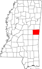
Kemper County, Mississippi Basics:
Kemper County Mississippi - Government Site
Population: 10,379
Area: 766 square miles
County seat: De Kalb
Area code(s) in use: 601 662
Time zone: CST
High school graduate or higher: 75.4%
Bachelor's degree or higher: 10.4%
Median household income: $27,471
Persons in poverty: 28.0%
Home ownership rate: 77.9%
Mean travel time to work: 29.5 minutes
Adjacent counties:
Lauderdale Neshoba Newton Noxubee Sumter (AL) Winston
Places in Kemper County, Mississippi
Giles Airport,
Joe Williams Naval Outlying Field Wild Horse Prairie 3 Mile Corner Volunteer Fire Department,
Choctaw Fire Department Station 3,
Damascus Volunteer Fire Department,
De Kalb Public Library,
De Kalb Volunteer Fire Department,
Kemper - Neshoba County / Regional Correctional Facility,
Kemper County Courthouse,
Kemper County Volunteer Fire District 3 Station,
Porterville Volunteer Fire Department,
Preston Fire Department,
Scooba Volunteer Fire Department King Canal Antioch Cemetery, Ashland Cemetery,
Bethany Springs Cemetery,
Binnsville Cemetery,
Blackwater Cemetery,
Blue Chapel Cemetery,
Bluff Springs Cemetery,
Briggs Chapel Cemetery,
Cedar Lawn Memorial Cemetery,
Center Ridge Cemetery,
Chamberlin Cemetery,
Chapel Hill Cemetery,
Cherry Cemetery,
Chisholm Cemetery,
Cole Cemetery,
Damascus Cemetery,
DeKalb Cemetery,
Dry Creek Cemetery,
Enondale Cemetery,
Felton Cemetery,
Giles Cemetery,
Hampton Cemetery,
Hensons Cemetery,
Hopewell Cemetery,
Jerusalem Cemetery,
Klondike Cemetery,
Liberty Cemetery,
Linwood Cemetery,
Macedonia Cemetery,
McDonald Cemetery,
McRae Cemetery,
Mount Hebron Cemetery,
Mount Olive Cemetery,
Mount Pleasant Cemetery,
New Hope Cemetery,
New Hope Cemetery, Oden Cemetery,
Old Scooba Cemetery,
Old Wahalak Cemetery,
Pawticfaw Cemetery,
Pinecrest Cemetery, Pleasant Grove Cemetery,
Pleasant Springs Cemetery,
Pleasant Springs Church Cemetery, Porterville Cemetery,
Robbins Cemetery,
Rush Cemetery,
Salem Cemetery, Scooba Cemetery,
Shepard Grove Cemetery,
Shepherd Cemetery,
Shiloh Cemetery,
Smith Cemetery,
Smyrna Cemetery,
Spring Hill Cemetery, Stovall Cemetery,
Talbert Cemetery, Tinsley Cemetery,
Tubb Cemetery,
Twin Cemeteries,
Union Cemetery,
Union Cemetery,
Van Devender Cemetery,
Wahalak Cemetery,
West Kemper Cemetery,
Zion Cemetery Alawine Springs Church,
Antioch Baptist Church,
Bay Springs Baptist Church,
Bethel Church,
Bethlehem Church,
Beulah Church,
Big Oak Church,
Binnsville United Methodist Church,
Blackwater Baptist Church,
Bloomfield Church,
Blue Chapel,
Bluff Springs Church,
Bodka Valley Church,
Briggs Chapel,
Brown Ridge Church,
Cedar Grove Church,
Center Ridge Baptist Church,
Center Ridge Church,
Center Ridge Church,
Chapel Hill Church,
Church of God,
Church of God,
Clarks Chapel,
Corinth Church,
Coy Church,
De Kalb Baptist Church,
Dry Creek Church,
Ebenezer Church,
Enondale Church,
Frazier Grove Church,
Friendship Baptist Church,
Friendship Church,
Hopewell Church,
Hopewell Church,
Jerusalem Church,
Kemper Church,
Kemper Springs Baptist Church,
Keys Chapel,
Liberty Baptist Church,
Liberty Church,
Little Zion Church,
Macedonia Church,
Mellen Church,
Mount Ararat Church,
Mount Cephus Church,
Mount Hebron Church, Mount Nebo Baptist Church (historical),
Mount Pleasant Church,
Mount Pleasant Church,
Mount Salem Church,
Mount Zion Church,
Mount Zion Church,
New Hope Church,
New Hope Church,
New Hope Church,
Pawticfaw Baptist Church (historical),
Persimmon Chapel,
Persimmon Ridge Church,
Philadelphia Baptist Church (historical),
Pilgrim Rest Church,
Pleasant Grove Church,
Pleasant Grove Church,
Pleasant Hill Church,
Pleasant Ridge Church,
Pleasant Springs Church,
Porterville Methodist Church,
Providence Church,
Saint Johns Church,
Shady Grove Church,
Shephard Church,
Shiloh Church,
Sinai Church,
Smyrna Church,
Spanish Oak Church,
Spring Hill Church,
Spring Hill Church,
Stonewall Church,
Sunflower Church,
Sunny Mount Giles Church,
Tamola Church,
Tucker Church,
Union Baptist Church,
Union Church,
Union Hall Church,
Union Hill Church,
Unity Springs Church,
Vardaman Church,
Wahalak First Baptist Church,
West Kemper Baptist Church,
Zion Church Yanceys Ferry (historical) A A Hopper Pond Dam,
Billy Harry Pond Dam,
Carlton Fleming Pond Dam,
Dorothy Stennis Pond Dam,
E Q Lunsford Pond Dam,
George Sciples Mill Pond Dam,
H C Jenkins Pond Dam,
Harry H Russell Pond Dam,
Hoppers Lake Dam,
Hugh Thomasson Lake Dam,
James Barnhanm Pond Dam,
Kempdale Lake Dam,
Larry Bell Pond Dam,
Lester May Lake Dam,
Odessa Briggs Pond Dam,
Shammack Creek Structure 2 Dam,
Spinks Pond Dam,
Thomas Mill Pond Dam,
W O Wilkerson Pond Dam,
Weyerhauser Lumber Company Lake Dam,
Weyerhauser Lumber Company Pond Dam,
Weyerhauser Lumber Company Pond Dam Riley-Kemper Community Hospital Bruton Pond Calverts Store (historical),
Johnsons Store (historical),
Kellis Store,
Moscow Recreational Vehicle Park Fort Stephens (historical) Akron,
Antioch (historical),
Ayanabi (historical),
Beckville (historical),
Binnsville,
Blackwater,
Bloomfield,
Bluff Springs,
Bogue Toocolo Chitto (historical),
Carters,
Center Ridge (historical),
Chomontakali (historical),
Cleveland,
Cow Creek (historical),
Coy,
Cullum,
Cuthi Uckehaca (historical),
Damascus,
Darnall (historical),
De Kalb,
East Abeika (historical),
East Coongetto (historical),
East Yazo Skatane (historical),
Electric Mills,
Enondale,
Giles,
Haanka Ullah (historical),
Hatchette (historical),
Herbert (historical),
Holihtasha (historical),
Kemper Springs,
Kipling,
Klondike,
Liberty,
Lynville,
Millington,
Moscow,
Mount Nebo,
Narkeeta (historical),
Oak Grove,
Oktibbeha (historical),
Old Narkeetah (historical),
Old Scooba (historical),
Old Wahalak (historical),
Peden (historical),
Porterville,
Preston,
Prince Chapel,
Prismatic,
Red Bud (historical),
Rio,
Rocky Mount (historical),
Sciples Mill,
Scooba,
Spinks (historical),
Sucarnoochee,
Tamola,
Texas (historical),
Townsend,
Wahalak Cullum Post Office (historical), Darnall Post Office (historical),
De Kalb Post Ofice, Enondale Post Office (historical), Giles Post Office (historical), Kellis Store Post Office (historical), Kemper Springs Post Office (historical), Kipling Post Office (historical), Millington Post Office (historical), Minden Post Office (historical), Moscow Post Office (historical), Mount Nebo Post Office (historical), Narkeeta Post Office (historical), Oak Grove Post Office (historical), Pawticfaw Post Office (historical), Pea Ridge Post Office (historical), Peden Post Office (historical),
Porterville Post Office,
Preston Post Office, Prince Post Office (historical), Prismatic Post Office (historical), Rio Post Office (historical), Rocky Mount Post Office (historical), Spinks Post Office (historical), Sucarnoochee Post Office (historical), Tamola Post Office (historical), Townsend Post Office (historical), Wahalak Post Office (historical), West Kemper Post Office (historical)
Bateman Lake,
Hoppers Lake,
Kempdale Lake Antioch School (historical),
Atwood School (historical),
Bay Springs School (historical),
Center Ridge School (historical),
Centerville School (historical),
Chapel Hill Grammar School (historical), Cleveland College (historical),
Delk School (historical),
East Kemper Elementary School, Enondale School (historical), Fairview College (historical), Fairview Male and Female Academy (historical),
Grange School (historical), Hopper School (historical), Independent Ridge School (historical),
Kemper Normal College (historical),
Little Rock School,
Lynville Attendance Center (historical),
Oak Grove School,
Oak Grove School (historical), Porterville Grammar School (historical),
Porterville High School (historical),
Preston School, Prince Chapel School (historical),
Rocky Point School (historical),
Shady Grove School (historical),
Spencer High School, Sucarnoochee School (historical),
Tamola School (historical), Townsend High School (historical), Tram Road School (historical),
West Kemper Elementary School,
West Kemper High School Bendix Creek,
Big Scooba Creek,
Blackwater Creek,
Caney Creek,
Cap Branch,
Chamberlin Creek,
Chickasawhay Creek,
Cow Creek,
Cullum Branch,
Dale Branch,
Delphia Creek,
Dry Creek,
Flat Creek,
Flat Scooba Creek,
Goolsby Creek,
Hamilton Branch,
Houston Creek,
Hull Branch,
Indian Branch,
Land Creek,
Liberty Branch,
Little Creek,
Little Minnow Creek,
Little Ross Branch,
Little Scooba Creek,
Mayo Branch,
Mineral Springs Branch,
Mosley Branch,
Parker Creek,
Pawticfaw Creek,
Penders Creek,
Pole Branch,
Poole Branch,
Pushacoona Creek,
Quilby Creek,
Running Creek,
Running Tiger Creek,
Seals Branch,
Sid Creek,
Snoody Creek,
Sorghum Branch,
Steel Creek,
Straight Creek,
Tallachula Creek,
Tifallili Creek,
Toles Branch,
Wahalak Creek,
Yazoo Creek Bull Mountain,
White House Mountain Porterville Lookout Tower,

