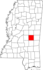
Newton County, Mississippi Basics:


Newton County Mississippi - Government Site

Population: 21,568
Area: 578 square miles
County seat: Decatur
Area code(s) in use: 601
Time zone: CST
High school graduate or higher: 83.1%
Bachelor's degree or higher: 13.3%
Median household income: $35,907
Persons in poverty: 19.3%
Home ownership rate: 78.4%
Mean travel time to work: 26.6 minutes


Adjacent counties:
Clarke  Jasper  Kemper  Lauderdale  Leake  Neshoba  Scott  Smith  
Find in Mississippi

Map of the Newton County area


Our detail map of Newton County shows the Newton County, Mississippi boundary lines and other interesting items.

Places in Newton County, Mississippi

  Airports     show all on map

James H Easom Field Airport, Rose Field Airport

  Buildings     show all on map

Conehatta Volunteer Fire Department, Decatur Volunteer Fire Department, Duffee Volunteer Fire Department, Gibbstown - Lawrence Volunteer Fire Department, Hickory Volunteer Fire Department, Newton City Hall, Newton Fire Department, Newton Public Library, Union Fire Department

  Canals     show all on map

Chunky Canal, Okahatta Canal, Warrior Canal

  Cemeteries     show all on map

Abney Cemetery, Baptist Cemetery, Brand Cemetery, Bufkin Cemetery, Decatur Cemetery, Doolittle Confederate Cemetery, Eureka Cemetery, Evans Cemetery, Ferguson Cemetery, Friendship Cemetery, Greenland Cemetery, Hickory Cemetery, Hollingsworth Cemetery, Indian Cemetery, Johnson Cemetery, Masonic Cemetery, McGee Cemetery, Memorial Park, Mount Carmon Cemetery, Mount Vernon Cemetery, Old Good Hope Cemetery, Old Norman Cemetery, Pine Grove Cemetery, Pleasant Hill Cemetery, Pleasant Ridge Cemetery, Spring Hill Cemetery

  Census     show all on map

Conehatta Census Designated Place

  Churches     show all on map

African Church (historical), Altarie Church, Antioch Chistian Church, Beatline Church, Bethel Church, Bethel Church, Bethel Church (historical), Bethelehem Church (historical), Bethelehem Church (historical), Bethlehem Church, Beulah Church, Blue Springs Church, Calvary Baptist Church, Cedar Grove Church, Center Ridge Church, Choctaw Church (historical), Chunky Baptist Church, Church of Christ, Conehatta Missionary Baptist Church, Corinth Church, Cross Roads Church, Duffee Church, Duffee Church, Duffee Church, Ebenezer Church, Erin Cumberland Church, Eureka Church, Evans Tabernacle, Faith Tabernacle Church, Fellowship Church, First Baptist Church, First Baptist Church, First Presbyterian Church, Gilmers Church, Good Hope Church, Good Hope Church, Green Grove Church, Greenland Baptist Church, Greenwood Church, Hazel Church, Hebron Church, Hopewell Church, Hudsons Chapel, Jerusalem Church, Lake Church, Lake Holiness Church, Lebanon Church, Liberty Church, Liberty Church, Little Rock Church, Little Zion Church, Lucern Church, Macedonia Church, Macedonia Church, Majure Church, Midway Church, Midway Church, Morning Star Baptist Church, Mount Carmon Church (historical), Mount Moriah Church, Mount Moriah Church, Mount Nebo Church, Mount Olive Church (historical), Mount Pleasant Church, Mount Pleasant Church, Mount Vernon Church, Mount Vernon Church, Mount Zion Church, Mount Zion Church, Mount Zion Church (historical), New Ireland Church, New Island Church (historical), Newton Christian Church, Newton Church of Christ, Newton First Methodist Protestant Church, Newton Presbyterian Church, Newton United Methodist Church, Oak Grove Church, Oakland Church, Pilgrim Grove Church, Pilgrim Rest Church, Pinckney Church, Pine Bluff Church, Pine Grove Church, Pine Ridge Church, Pine Ridge Church, Pleasant Grove Church, Pleasant Hill Church, Pleasant Ridge Baptist Church, Pleasant Valley Church, Poplar Church, Poplar Springs Church, Possum Trot Church (historical), Prospect Church, Prospect Church, Reids Chapel, Rock Branch Church, Rock Creek Church, Rock Hill Church (historical), Roman Hill Church, Saint Catherine Church, Saint Clyde Church, Saint Hill Church, Saint John Church, Saint Mary Church, Sand Ridge Church, Sand Springs Church, Shady Grove Church, Sharon Church, Shiloh Church, Spring Hill Church, Spring Hill Church, Sunny Hill Church, Trinity Episcopal Church, Truelight Church, Union Chapel Church, Union Church, Union Church, Union United Methodist Church, West Decatur Church, White Plains Church, White Plains Church, White Stone Church

  Crossings     show all on map

Interchange 100, Interchange 109, Interchange 115, Interchange 121

  Dams     show all on map

B J Blount Lake Dam, B L Griffin Lake Dam, Bill May Lake Dam, C Loper Catfish Pond Dam, C M Blount Lake Dam, Carroway Lake Dam, Charles Guin Lake Dam, Chunky River Watershed 47 Dam, Chunky Watershed Structure 5 Dam, County Pond Dam, D Graham Lake Dam, Doctor Laird Lake Dam, Doctor Moore Lake Dam, E J Pearson Lake Dam, Earl Laird Lake Dam, Earl Laird Lake Dam, Ecjc Lake Dam, Fahrbach Lake Dam, Germeny Lake Dam, Henry Lake Dam, McMullan Lake Dam, McMullan Lake Dam, Mrs Graham Lake Dam, Newton Lagoon Dam, Osborn Lake Dam, P Measells Lake Dam, Pearsons Catfish Pond Dam, Pearsons Catfish Pond Dam, R Doolittle Pond Dam, Spring Lake Hunting Club Lake Dam, Stovall Lake Dam, T Herd Lake Dam, T L Harris Lake Dam, Tommy Graham Pond Dam, Troy Brand Lake Dam, W Parks Lake Dam

  Hospitals     show all on map

Laird Hospital, Meadowview Hospital, Pioneer Community Hospital of Newton

  Lakes     show all on map

Kennedy Pond, Ozborn Lake, Stamper Pond

  Locales     show all on map

Addy Store (historical), Barnes Mill (historical), Chaney Store (historical), Crosby Mill (historical), Dollars Store (historical), Graham Store (historical), Greens Mill (historical), Hammond Store (historical), Hunters Mill (historical), Leach Store (historical), Millins Mill (historical), Mississippi State Experimental Station, Moores Mill (historical), Patrons Union Campground, Pearsons Mill (historical), Pierce Store (historical), Pinkney Mill (historical), Sharps Store (historical), Storys Store (historical), Tinsdale Store (historical), Tuckers Mill (historical), Vance Mill (historical), Vance Store (historical), Watkins Store (historical), Williams Store (historical)

  Populated Places     show all on map

Bartlett, Battlefield (historical), Bethel, Beulah, Bissaasha (historical), Blounts Store, Calhoun, Cedar Grove, Center Ridge, Chunky, Chunky (historical), Coatraw (historical), Conehatta, Decatur, Doolittle (historical), Duffee, Ebenezer, Evergreen (historical), Goodhope, Greenfield (historical), Greenland, Hazel, Hickory, Hubbard, Jeff, Lawrence, Lebanon, Liberty, Little Rock, Little Rock (historical), Lucern, Mount Vernon, New Ireland, New Providence, Newton, Oka Hullo (historical), Oka Kapassa (historical), Okahta Talaia (historical), Patrons Union (historical), Paula (historical), Perdue, Perota (historical), Pilgrim Grove, Pine Bluff, Poplar Springs, Prospect, Roberts, Rock Branch, Rock Creek, Roscoe (historical), Scanlon (historical), Six Towns (historical), Stamper (historical), Stratton, Tallow (historical), Tanglewood, Toomer (historical), Union, Urbo (historical), Volcan (historical), Wickward (historical), Willoughby

  Post Offices     show all on map

Bartlett Post Office (historical), Battlefield Post Office (historical), Lucern Post Office (historical), Nanahuma Post Office (historical), Prospect Post Office (historical), Roberts Post Office (historical), Roscoe Post Office (historical), Stamper Post Office (historical)

  Reservoirs     show all on map

Carson Pond, Community Pond, County Pond, Daniel Lake, Horne Mill Pond, Spring Lake, Wanitka Lake, Wickware Pond

  Schools     show all on map

Battlefield School (historical), Beat Line School (historical), Berry School (historical), Beulah School (historical), Beulah-Hubbard School (historical), Blackwell School (historical), Buena Vista School (historical), Cedar Grove School (historical), Center Point School (historical), Center Ridge School (historical), Chapel Hill School (historical), Chestnut Ridge School (historical), Chestnut Springs School, Clark Memorial College, Conehatta High School, Conehatta Institute (historical), Conehatta School, Consolidated School (historical), County Line School (historical), Decatur Attendance Center (historical), Doolittle School (historical), East Central Community College, Erin School (historical), Goodnews School (historical), Green Grove School, Hickman Chapel School (historical), Hickory Attendance Center (historical), Hickory Grove School (historical), Hickory Institute (historical), High Heel School (historical), Hunnicut School (historical), Lawrence Institute (historical), Liberty Hill School (historical), Liberty School (historical), Maple Springs School (historical), Mount Zion School, Newton County Elementary School, Newton County High School, Newton Male and Female College (historical), Newton Vocational School, Oak Grove School (historical), Parks School (historical), Pine Grove School (historical), Pine Grove School (historical), Pine Grove School (historical), Pine Ridge School (historical), Poplar Springs School (historical), Progress School (historical), Rush School (historical), Saint John School (historical), Saint Paul School (historical), Spring Chapel School (historical), Spring Hill School (historical), Sweetwater School (historical), Sycamore School (historical), Tallahala School (historical), Thirteenth School (historical), Union Grove School (historical), Union Ridge School (historical), Wall School (historical), Walnut School (historical), Why Not School (historical), Witts School (historical)

  Springs     show all on map

Gum Spring, Sulphur Spring

  Streams     show all on map

Barnett Creek, Bethel Branch, Bethel Creek, Big John Branch, Blue Branch, Bogue Falema Creek, Box Creek, Brushy Creek, Buck Branch, Caney Creek, Carlton Branch, Chunky Creek, Cleveland Branch, Concobona Creek, Conehatta Creek, Craney Branch, Decatur Branch, Dorman Branch, Dorsey Branch, Dry Branch, Dry Branch, Dunnagin Creek, Gum Pond Branch, Hale Branch, Hallman Branch, Hensley Branch, Hitts Branch, Hog Branch, Huckleberry Creek, John Cook Branch, Johnson Creek, Laird Branch, Little Rock Creek, Mayatte Creek, McMullan Branch, Nelson Creek, Okahatta Creek, Parker Branch, Potterchitto Creek, Pumpkin Creek, Reese Branch, Reeves Branch, Richardson Mill Creek, Riley Branch, Riser Creek, Rock Branch, Roebuck Branch, Sand Branch, Scotchenflipper Creek, Sellers Creek, Simmons Branch, Sivils Creek, Smith Branch, Tallashua Creek, Tarlow Creek, Threat Branch, Tonacana Creek, Townsend Branch, Turkey Creek, Walker Branch, Witt Creek

  Summits     show all on map

Diamond Hill, Nance Hill

  Towers     show all on map

Newton Lookout Tower, WBKN Radio Tower (Biloxi), WMYQ-AM (Newton), WMYQ-FM (Newton),

Newton County, Mississippi Population By Race (2012 estimate)

RacePopulation
WhiteNewton County White population 13,69613,695  
BlackNewton County Black population 6,5576,556
American IndianNewton County American Indian population 1,0351,035
MixedNewton County Mixed population 173172
AsianNewton County Asian population 8686
Hawaiian & Pacific IslanderNewton County Hawaiian & Pacific Islander population 00

Additional population tables :
State population table
Mississippi population by county