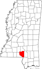
Marion County, Mississippi Basics:
Marion County Mississippi - Government Site
Population: 26,395
Area: 542 square miles
County seat: Columbia
Area code(s) in use: 601
Time zone: CST
High school graduate or higher: 76.3%
Bachelor's degree or higher: 13.2%
Median household income: $31,865
Persons in poverty: 25.7%
Home ownership rate: 78.1%
Mean travel time to work: 33.4 minutes
Adjacent counties:
Jefferson Davis Lamar Lawrence Pearl River Walthall Washington (LA)
Places in Marion County, Mississippi
Browns Landing Airport,
Circle Bar Ranch Airport,
Columbia-Marion County Airport,
Porter Airport,
Pyramid Unicom Airport New Bridge,
Old Bridge (historical) Columbia City Hall,
Columbia Fire Department Station 1,
Columbia Fire Department Station 2,
Columbia Health and Rehabilitation Center,
Foxworth Fire Department,
Marion - Walthall County / Regional Correctional Facility,
Marion County Courthouse,
Pine Burr Volunteer Fire Department,
Southwest Marion Fire Department,
Southwest Marion Fire Department Foxworth,
Southwest Marion Fire Department Sandy Hook,
Star B Rest Personal Care Home,
The Grove Nursing Home Center,
The Myrtles Assisted Living,
Tri - Community Volunteer Fire Department Station 1,
Tri - Community Volunteer Fire Department Station 2,
Tri - Community Volunteer Fire Department Station 3,
Tri - Community Volunteer Fire Department Station 4,
Tri - Community Volunteer Fire Department Station 5 Allen Cemetery,
Antioch Cemetery, Barnes Cemetery,
Baylis Chapel Cemetery, Blackburn Cemetery,
Breakfield Cemetery,
Broom Cemetery,
Bunker Hill Cemetery,
Bunker Hill Memorial Cemetery,
Capp Cemetery,
Cedar Grove Cemetery,
Clear Creek Cemetery,
Columbia City Cemetery,
Cook Cemetery,
Darbun Cemetery,
East Columbia Cemetery,
Ebenezer Cemetery,
Emmanuel Cemetery,
Enon Cemetery,
Expose Cemetery,
Ford Cemetery,
Ford Chapel Cemetery,
Fortenberry Cemetery,
Foxworth Cemetery,
Friendship Cemetery,
Good Hope Cemetery,
Harmony Cemetery,
Holly Springs Cemetery, Holmes Cemetery,
Hopewell Cemetery,
Hurricane Creek Cemetery,
Improve Cemetery,
Kokomo Cemetery,
Little Rock Cemetery,
Lott Memorial Cemetery,
Morgantown Cemetery,
Mount Gilead Cemetery,
Mount Sinai Cemetery,
New Damascus Cemetery,
New Hope Cemetery,
New Union Cemetery,
New Zion Cemetery,
North Columbia City Cemetery,
Oak Grove Cemetery,
Old Broom Cemetery,
Pearl River Cemetery,
Pinebur Cemetery,
Pleasant Hill Cemetery,
Pope Cemetery,
Randle Cemetery,
Raybourn Cemetery,
Richland Creek Cemetery,
Rose Hill Cemetery,
Rose Hill Cemetery,
Sandy Hook Cemetery,
Sandy Hook Cemetery,
Singley Cemetery,
Smith Cemetery,
Spring Cottage Cemetery,
Stringer Cemetery,
Stringer Cemetery,
Sunflower Cemetery,
Thompson Chapel Cemetery,
Tolar Cemetery,
Turnage Chapel Cemetery,
Warren Cemetery,
Watts Cemetery,
Wilks Cemetery,
Woodlawn Cemetery Foxworth Census Designated Place Antioch Baptist Church,
Antioch Church,
Attam Ministries,
Baylis Chapel,
Blue Spring Church,
Brushy Creek Church,
Bunker Hill Baptist Church,
Calvary Baptist Church,
Cedar Grove Church,
Christian Hill Baptist Church,
Christian Hill Church,
Christian Union Church,
Church of Christ,
Church of God in Christ,
Clear Creek Church,
Columbia Presbyterian Church,
Columbia Valley Methodist Church,
Durban Mennonite Church,
East Columbia Church,
Edna Church,
Emmanuel Church,
Enon Church,
Faithway Landmark Church,
First Assembly of God Church,
First Baptist Church,
First United Methodist Church,
Ford Chapel,
Foxworth First Baptist Church,
Friendship Church,
Gates Road Church,
Good Hope Church,
Goss Baptist Church,
Grace Point Worship Center,
Graves Creek Church,
Harmony Church,
Holly Springs Church,
Hopewell Church,
Hub Church,
Hurricane Creek Church,
Improve Church,
Kokomo Baptist Church,
Little Rock Church,
Macedonia Church,
Macedonia Church,
Mays Creek Church,
Morgantown Church of God,
Morning Star Church,
Mount Bethel Church,
Mount Carmel Church,
Mount Gilead Church,
Mount Sinai Church,
New Damascus Church,
New Hope Baptist Church,
New Hope Church,
New Jerusalem Church of God,
New Union Church,
New Zion Methodist,
North Columbia Baptist Church,
North Columbia Church of God,
Oak Grove Church,
Old Spring Cottage Church (historical),
Pearl River Church,
Pinebur Church,
Pleasant Hill Church,
Pleasant Valley Church,
Richland Creek Church,
Rose Hill Church,
Rose Hill Church,
Saint Marys Church,
Saint Paul Church,
Saint Stephens Episcopal Church,
Sanctified Church (historical),
Sandy Hook Baptist Church,
Shady Grove Church,
Shiloh Baptist Church,
Spring Hill Church,
Sunflower Church,
Sunlight Church,
Sweet Home Church,
Sweet Valley Church,
Temple Baptist Church,
Terrys Chapel,
True Vine Baptist Church,
Turnage Chapel,
United Church,
Unity Baptist Church,
West Columbia Church of God,
White Bluff Church,
Zion Hill Church (historical) Red Bluff Andersons Canal Structure Two Dam,
Bass Lake Dam,
Bill Waller Lake Dam,
Columbia Sewage Lagoon Dam,
Columbia Training School Lake Dam,
Earkan Lake Dam,
Fortenberry Lake Dam,
Holiday Creek Structure 4 Dam,
Kobrock Lake Dam,
Lake Columbia Dam,
Long Horn Lake Dam,
McDaniels Pond Dam,
Michelle Lake Dam,
Shaw Ponds Dam,
Singley Lake Dam,
Singley Lake Dam,
Singley Ponds Dam,
Stogner Lake Dam,
Tolar Ponds Dam,
Tom Watts Lake Dam,
W E Stogner Lake Dam,
Whitehead Lake Dam Applewhite Private Hospital (historical), Columbia Clinic Hospital (historical),
Dalys Hospital (historical),
Marion General Hospital Black Lake,
Black Lake,
Blue Lake,
Harper Lake,
Spains Lake,
Yellow Lake 3J Poultry Ranch,
Air Industrial Park,
Bass Poultry Farm,
Bayliss Water Mill (historical),
Bucking Spur Ranch,
Columbia Country Club,
East Marion Community Center,
Mimosa Landing Campground,
Prisk Poultry Farms,
Rials Farms,
Summers Poultry Farm,
West Sauer (historical),
Wilkes Mill (historical) Fords Fort (historical) Columbia Oil Field,
East Morgantown Oil Field,
Greens Creek Oil Field,
Hub Oil Field,
Improve Oil Field,
Knoxo Oil Field,
Morgantown Oil Field,
Newson Oil Field Columbia Water Park,
Duckworth Park,
Gardner Stadium,
Marion County State Wildlife Management Area,
Westerfield Little League Ball Park Bethel,
Bunker Hill,
Carmich,
Cheraw,
Columbia,
Columbia Springs (historical),
Ebenezer,
Edna,
Emmanuel,
Enon,
Expose,
Fordsville (historical),
Fortenberry,
Foxworth,
Good Hope,
Goss,
Hamage,
Harmony,
Holly Springs,
Hopewell,
Hub,
Hurricane Creek,
Improve,
Jamestown,
Keno (historical),
Kokomo,
Lampton,
Lightville (historical),
Lovelace,
Mildred,
Morgantown,
Natcole,
New Hope,
New Union,
Newsom,
Pickwick,
Pinebur,
Saint Paul,
Sandy Hook,
Sauer,
Saxon,
Spring Cottage,
Sumbax,
Twin,
White Bluff Edna Post Office (historical), Fordsville Post Office (historical),
Foxworth Post Office, Hub Post Office (historical), Improve Post Office (historical), Keno Post Office (historical),
Kokomo Post Office, Lampton Post Office (historical), Lataiuer Post Office (historical), Orangeburg Post Office (historical), Pinebur Post Office (historical)
Lake Bill Waller,
Lake Columbia,
Lake Watts Buford Consolidated School (historical),
Bunker Hill School,
Cedar Grove School (historical),
Clear Creek School (historical),
Columbia Academy,
Columbia Academy,
Columbia Elementary School,
Columbia High School,
Columbia Junior High School,
Columbia Primary School,
Columbia Training School,
Edna School (historical),
Fords School (historical),
Friendship School (historical),
Goss School (historical),
Harmony Private School (historical),
Hopewell School (historical),
Hub Attendance Center,
Hurricane Creek School (historical),
Improve School,
Jefferson Elementary School,
Jefferson Middle School,
Kokomo School,
La Marion School (historical), Lampton Vocational School (historical),
Marion County High School,
Marion County Vocational School,
Morgantown High School, Morris School (historical),
Petty School (historical),
Pine Grove School (historical), Pinebur School (historical),
Saint Paul School (historical),
Sandy Hook School (historical), Spring Cottage School (historical), Tar Kiln School (historical),
Union School (historical),
Water Valley School (historical),
West Marion High School,
West Marion Primary School Hollywood Spring Ball Mill Creek,
Balls Mill Creek,
Beaver Dam Creek,
Beaver Dam Creek,
Big Creek,
Black Branch,
Boggy Prong,
Brushy Creek,
Buckhorn Creek,
Clay Hill Creek,
Clear Creek,
Collins Creek,
Cook Creek,
Crooked Creek,
Cypress Creek,
Dillon Creek,
Dry Creek,
Dry Creek,
Dry Creek,
Elbow Branch,
Fenny Creek,
Graves Creek,
Gully Creek,
Harper Creek,
Holiday Creek,
Hurricane Creek,
Indian Creek,
Jones Creek,
Little Prong Creek,
Long Branch,
Long Branch,
Lower Little Creek,
Mays Creek,
Middle Fork Creek,
Mike Tom Branch,
Mill Creek,
Pierce Creek,
Rankin Mill Creek,
Rawls Creek,
Richland Creek,
Sandy Hook Creek,
Sheep Pen Branch,
Silver Creek,
Sweetwater Creek,
Tenmile Creek,
Thompson Creek,
Turkey Branch,
Twitty Creek,
Upper Little Creek,
Wolf Island Branch Red Hill,
Stony Point Hill Allen Bay,
Rawls Bay Improve Lookout Tower,
Pinebur Lookout Tower,
W45A-TV (Columbia),
WCJU-AM (Columbia),
WFFF-AM (Columbia),
WFFF-FM (Columbia),

