Montgomery County, Mississippi Basics:


Montgomery County Mississippi - Government Site

Population: 10,596
Area: 407 square miles
County seat: Winona
Area code(s) in use: 662
Time zone: CST
High school graduate or higher: 73.6%
Bachelor's degree or higher: 13.3%
Median household income: $30,440
Persons in poverty: 32.5%
Home ownership rate: 73.2%
Mean travel time to work: 23.5 minutes
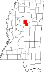
Adjacent counties:
Attala  Carroll  Choctaw  Grenada  Webster  

Find in Mississippi

Map of the Montgomery County area


Our detail map of Montgomery County shows the Montgomery County, Mississippi boundary lines and other interesting items.

Places in Montgomery County, Mississippi

  Airports     show all on map

Winona-Montgomery County Airport

  Bridges     show all on map

Dorris Bridge (historical), Lindsay Bridge (historical)

  Buildings     show all on map

Duck Hill Volunteer Fire Department, Dunns Store (historical), Kilmichael Volunteer Fire Department, Montgomery County Courthouse, Poplar Creek Volunteer Fire Department, Stewart Volunteer Fire Department, Winona Fire Department

  Cemeteries     show all on map

Adams Cemetery, Bethesda Cemetery, Bethesda Cemetery, Bethlehem Cemetery, Biblical Garden Cemetery, Branscome Cemetery, Bronte Cemetery, Center Cemetery, Duck Hill Cemetery, Dunn Cemetery, Flowers Cemetery, Forest Hill Cemetery, Goodin Cemetery, Griffin Cemetery, Griffin Cemetery, Hays Creek Cemetery, Hays Creek Cemetery, Joe Walker Cemetery, Jordans Cemetery, Kindred Cemetery, Lindsey Springs Cemetery, Loggins Cemetery, Marshill Cemetery, Mason Cemetery, Mission Cemetery, Mount Pisgah Cemetery, Mount Pleasant Cemetery, Mulberry Cemetery, New Hope Cemetery, New Liberty Baptist Church Cemetery, Oakwood Cemetery, Old Friendship Cemetery, Old Friendship Cemetery, Old Northern Grocery Cemetery, Old Pine Bluff Cemetery, Pine Grove Cemetery, Pittman Cemetery, Pleasant Grove Cemetery, Prospect Cemetery, Prospect Cemetery, Purnell Cemetery, Red Hill Cemetery, Saint Johns Cemetery, Salem Cemetery, Shady Grove Cemetery, Shiloh Cemetery, Shiloh Cemetery, Spring Hill Cemetery, Stinson Cemetery, Taylor Cemetery, Townsend Cemetery, Wilkins Cemetery, Williams Cemetery, Wilmount Cemetery, Wilson Cemetery

  Churches     show all on map

Bethany Church, Bethel Church, Bethel Church, Bethesda Church, Bethlehem Church, Bethlehem Church, Bethlehem Church, Bethsaida Church, Campbell Hill Church, Center Hill Church, Church of the Living God, Columbiana Church, Columbiana Church, Covenant Church, Duck Hill Baptist Church, Elkhorn Church, First Baptist Church, First Presbyterian Church, Friendship Church, Friendship Church, Haven United Methodist Church, Hays Creek Church, Hays Creek Church, Hazel Green Church, Hebron Church, Hopewell Church, Huntsville Church of Christ, Kilmichael Baptist Church, Kingdom Hall of Jehovahs Witnesses, Lindsey Spring Church, Marshill Church, Mission Church, Moore Memorial United Methodist Church, Mount Pisgah Church, Mount Pleasant Church, Mount Vernon Church, Mulberry Baptist Church (historical), Nations Poplar Creek Church, New Hope Church, New Liberty Baptist Church, North Winona Baptist Church, Northside Church, Pine Bluff Church, Pinkey Grove Church, Pleasant Grove Church, Pleasant Hill Church, Pleasant Spring Church, Poplar Springs Union Church, Prospect Church, Prospect Church, Red Hill Church, Saint Johns Church, Saint Mark Church, Salem Church, Scotland Church, Shady Grove Church, Shiloh Baptist Church, Spring Hill Church, Spring Hill Number 2 Church, Sweet Home Church, Unity Church, Wilkins Chapel, Wilmount Church, Winona Baptist Church, Winona Baptist Temple, Youngs Chapel

  Crossings     show all on map

Interchange 185, Sewells Ferry (historical)

  Dams     show all on map

American Legion Lake Dam, Blaylock Pond Dam, Bogue Watershed Y-30-31 Dam, Bogue Watershed Y-30-34 Dam, Bogue Watershed Y-30-43 Dam, Bogue Watershed Y-30-51 Dam, Bogue Watershed Y-30-52 Dam, Bogue Watershed Y-30-57 Dam, Bogue Watershed Y-30-58 Dam, Bogue Watershed Y-30-84 Dam, Bogue Watershed Y-30-89 Dam, Bogue Watershed Y-30-94 Dam, Bogue Watershed Y-30-95 Dam, Bogue Watershed Y-54-38 Dam, Elmer Pruitt Pond Dam, G E Mason Catfish Pond Dam, G E Mason Catfish Ponds Dam, G H Curtis Lake Dam, Gaylon Williams Lake Dam, H M Alexander Lake Dam, J H Collins Lake Dam, J W Braswell Pond Dam, Kilmichael Lagoon Dam, Mississippi No Name 222 Dam, Mississippi No Name 223 Dam, Mississippi No Name 224 Dam, Mississippi No Name 226 Dam, Rodney Mortimer Lake Dam, W M Lott Pond Dam, Windham Dam, Winona Country Club Dam, Winona Sewage Lagoon Dam

  Hospitals     show all on map

Kilmichael Hospital, Tyler Holmes Memorial Hospital

  Locales     show all on map

Binford (historical), Choctawville (historical), Dabney (historical), Elliott (historical), Ferguson Box (historical), Kilgore (historical), Laura (historical), Middleton (historical), Nation Community Center, Simpsons Shop (historical), Thrailkill (historical), Winona Country Club, Wolf Creek (historical)

  Populated Places     show all on map

Alva, Cedar Hill, Duck Hill, Eskridge, Foltz, Fox, Hendrix, Huntsville, Kilmichael, Lilac, Lodi, Minerva, Poplar Creek, Poplar Springs, Sawyer, Sibleyton, Stewart, Sugar Hill, Sweatman, Winona

  Post Offices     show all on map

Alva Post Office (historical), Cedar Hill Post Office (historical), Huntsville Post Office (historical), Laura Post Office (historical), Lilac Post Office (historical), Lodi Post Office (historical), Minerva Post Office (historical), Sibleyton Post Office (historical), Winona Post Office

  Reservoirs     show all on map

American Legion Lake, Beat Three Lake, Milligan Springs Lake

  Schools     show all on map

Centerside School, Duck Hill Elementary School, Duck Hill High School, Edwards School, Hays Creek School, Kilmichael Elementary School, Kilmichael High School, Kilmichael Vocational High School, Knox High School, Prospect School, Saint Johns School, Spring Hill School, Sweet Home School, Winona High School, Winona Junior High School, Young School

  Streams     show all on map

Armstrong Branch, Bogue Creek, Bywy Creek, Campbell Creek, Campbells Branch, Caney Creek, Clear Creek, Coffe Branch, Collins Gulley Creek, Crape Creek, Davidson Creek, Dunn Creek, East Fork Bogue Creek, East Fork Lewis Creek, Eskridge Creek, Flowers Creek, Gum Branch, Horse Creek, Horsepen Branch, Hurricane Branch, Jacks Slough, Jackson Creek, Larg Branch, Lewis Creek, Little Horse Creek, Little Mouse Creek, Little Mulberry Creek, Little Poplar Creek, Lodi Creek, Mouse Creek, Mulberry Creek, Murrell Branch, Old Channel Big Black River, Parkers Creek, Poplar Creek, Powell Creek, Powells Creek, Red Hill Branch, Reed Creek, Scott Branch, Sykes Creek, West Fork Lewis Creek, Wilkins Creek, Wolf Creek, Worsham Creek, Young Creek

  Towers     show all on map

Montgomery Lookout Tower, WONA-AM (Winona), WONA-FM (Winona), WONA-FM (Winona),

Montgomery County, Mississippi Population By Race (2012 estimate)

RacePopulation
WhiteMontgomery County White population 5,6265,626  
BlackMontgomery County Black population 4,8644,863
MixedMontgomery County Mixed population 5352
AsianMontgomery County Asian population 3231
American IndianMontgomery County American Indian population 2121
Hawaiian & Pacific IslanderMontgomery County Hawaiian & Pacific Islander population 00

Additional population tables :
State population table
Mississippi population by county