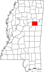
Oktibbeha County, Mississippi Basics:
Oktibbeha County Mississippi - Government Site
Population: 48,992
Area: 458 square miles
County seat: Starkville
Area code(s) in use: 662
Time zone: CST
High school graduate or higher: 86.7%
Bachelor's degree or higher: 43.1%
Median household income: $29,430
Persons in poverty: 34.2%
Home ownership rate: 50.1%
Mean travel time to work: 17.9 minutes
Adjacent counties:
Choctaw Clay Lowndes Noxubee Webster Winston
Places in Oktibbeha County, Mississippi
George M Bryan Airport,
Oktibbeha Airport Adaton - Self Creek Volunteer Fire Department,
Central Oktibbeha Fire Department,
East Oktibbeha Volunteer Fire Department,
East Oktibbeha Volunteer Fire Department Osborne Station,
East Oktibbeha Volunteer Fire Department Sessums Station,
Humphrey Coliseum,
Maben Volunteer Fire Department,
Mitchell Memorial Library,
Oktibbeha County Courthouse,
Oktibbeha County District 5 Volunteer Fire Department Station 1,
Oktibbeha County District 5 Volunteer Fire Department Station 2,
Oktibbeha County Heritage Museum,
Starkville City Hall,
Starkville Fire Department Station 1,
Starkville Fire Department Station 2,
Starkville Fire Department Station 3,
Starkville Fire Department Station 4,
Starkville Public Library Jordan Canal,
Trim Cane Canal Adaton Cemetery,
Adaton Cemetery,
Associated Reform Presbyterian Cemetery,
Beg Creek Cemetery,
Bethel Cemetery,
Bethel Cemetery,
Bethesda Cemetery,
Boyd Cemetery,
Cedar Grove Cemetery,
Center Grove Cemetery,
Clear Springs Cemetery,
Colcolough Cemetery,
Community Club Cemetery,
Craig Springs Cemetery,
Crigler Cemetery,
Curtis Chapel Cemetery,
Double Springs Cemetery,
Double Springs Cemetery,
Fox Cemetery, Halbert Cemetery, Harvey Cemetery,
Josey Creek Cemetery,
Lost Cemetery,
Mayhew Mission Cemetery,
McClelland Cemetery,
McMinn Cemetery,
Memorial Garden Park Cemetery,
Morgan Chapel Cemetery,
Mount Olive Cemetery,
New Hope Cemetery,
Old Presbyterian Cemetery,
Old Sturgis Cemetery, Outlaw-Harvey Cemetery,
Parrish Cemetery,
Pearsons Chapel Cemetery,
Peters Cemetery,
Pleasant Ridge Cemetery,
Rice Cemetery,
Salem Cemetery,
Sanders Cemetery,
Seitz Cemetery,
Self Creek Cemetery,
Sessums Cemetery, Shaw Family Cemetery, Spencer Family Cemetery,
Stewart Cemetery,
Sturgis Cemetery,
Wake Forest Cemetery Mississippi State Census Designated Place Adaton Baptist Church,
Adaton United Methodist Church,
Aldersgate United Methodist Church,
Antioch Missionary Baptist Church,
Austin Church of Christ Holiness,
Belaire Church,
Bethel Baptist Church,
Bethel Church,
Bethel Missionary Baptist Church,
Bethesda Baptist Church,
Bethlehem Church,
Big Creek Methodist Church,
Blackjack Missionary Baptist Church,
Bradley Church of God,
Broadmoore Church,
Calvary Baptist Church,
Cedar Grove Baptist Church,
Center Grove Baptist Church,
Chapel Hill Baptist Church,
Chapel of Memories,
Chestnut Grove Baptist Church,
Church of Christ,
Church of God,
Church of the Living God,
Clear Springs Primitive Baptist Church,
Community Club Church,
Curtis Chapel,
Double Springs Baptist Church,
Double Springs Methodist Church,
East Starkville Church,
Ebenezer Baptist Church,
Emmanuel Baptist Church,
Episcopal Church of the Resurrection,
Faith Baptist Church of Starkville,
Faith Pentecostal Church of God,
First Assembly of God Church,
First Baptist Church,
First Baptist Church of Longview,
First Church of Christ Holiness,
First John Missionary Baptist Church,
First Presbyterian Church,
First United Methodist Church,
First United Pentecostal Church,
Friendship Baptist Church,
Good Hope Baptist Church,
Griffin United Methodist Church,
Grove Baptist Church,
Jones Chapel Baptist Church,
Josey Creek Baptist Church,
Kingdom Hall,
Liberty Hill United Methodist Church,
Little Spring Hill Baptist Church,
Longview Baptist Church,
Longview Methodist Church,
Lumis Church,
Maben Church of Christ,
Maben First Baptist Church,
Maben United Methodist Church,
Mayhew Mission (historical),
Meadowview Baptist Church,
Morgan Chapel Baptist Church,
Mount Airy Baptist Church,
Mount Olive Baptist Church,
Mount Peiler Church,
Mount Zion Missionary Baptist Church,
New Bethel Baptist Church,
New Hope Baptist Church,
New Light United Methodist Church,
New Prospect Baptist Church,
Pearsons Chapel,
Peters Rock Temple Church of God in Christ,
Pierce Chapel (historical),
Pine Grove Baptist Church,
Plair United Methodist Church,
Pleasant Grove Baptist Church,
Pleasant Grove United Methodist Church,
Pleasant Hill Church,
Pleasant Ridge Baptist Church,
Prairie Grove Baptist Church,
Prince of Peace Lutheran Church,
Redeemer Church,
Reform Presbyterian Church (historical),
Robinson Missionary Baptist Church,
Rockhill United Methodist Church,
Saint Joseph Catholic Church,
Saint Mark Church,
Saint Matthews Church,
Saint Paul Baptist Church,
Salem Baptist Church (historical),
Sand Creek Chapel Missionary Baptist Church,
Second Baptist Church,
Self Creek Bible Baptist Church,
Self Creek Southern Baptist Church,
Sessums Methodist Church,
Silver Ridge Church,
Sixteenth Section Missionary Baptist Church,
Spring Hill Missionary Baptist Church,
Sturgis Baptist Church,
Sturgis Presbyterian Church,
Sturgis United Methodist Church,
Trinity Presbyterian Church,
True Vine Church,
Union Hill Baptist Church,
Vernon Cumberland Presbyterian Church (historical),
Victory Missionary Baptist Church,
Wake Forest Baptist Church,
Zion Cypress Methodist Church,
Zion Franklin United Methodist Church Lyons Bluff Atkinson Lake Dam,
Bluff Lake Dam,
Bock Lake Dam,
Butler Lake Dam,
Camps Lake Dam,
Coleman Lake Dam,
Colemans Lake Dam,
Crain Lake Dam,
Crumpton Lake Dam,
Davis Lake Dam,
Dodson Lake Dam,
Dorman Lake Dam,
Gordon Lake Dam,
Gray Lake Dam,
Hall Lake Dam,
Howell Lake Dam,
Howell Lake Dam,
Jackson Lake Dam,
Johnson Lake Dam,
Johnson Lake Dam,
Johnson Lake Dam,
Jones Lake Dam,
Keller Lake Dam,
Kleban Lake Dam,
Kleban Lake Dam,
Laughlin Lake Dam,
Livingston Lake Dam,
Long Lake Dam,
Lost Lake Dam,
Love Lake Dam,
Love Lake Dam,
Lyle Lake Dam,
Massey Lake Dam,
McHann Lake Dam,
McKinnon Lake Dam,
McMinn Lake Dam,
Mississippi State College Lake Dam,
Mitchell Lake Dam,
Mitchell Lake Dam,
Montford Lake Dam,
Mullins Lake Dam,
Norris Lake Dam,
Oakley Lake Dam,
Oktibbeha County Lake Dam,
Oswalt Lake Dam,
Page Lake Dam,
Parish Lake Dam,
Parish Lake Dam,
Pennell Lake Dam,
Randle Lake Dam,
Ratliff Lake Dam,
Shaw Lake Dam,
Slaughter Lake Dam,
Slaughter Lake Dam,
Spruell Lake Dam,
Stacy Lake Dam,
Starkille Lagoon Dam,
Starkville Gun Club Lake Dam,
Starkville Lagoon Dam,
Starkville Sewage Lagoon Dam,
Starkville Sewage Lagoon Dam,
State College Sewage Lagoon Dam,
Strickland Lake Dam,
Sykes Lake Dam,
Tuckaway Lake Dam,
Turner Lake Dam,
Watkins Lake Dam,
White Lake Dam,
Wilkerson Lake Dam Mississippi State University School of Forest Resources Parker Slough Oktibbeha County Hospital Agency (historical),
Bells Mill (historical),
Bethel (historical),
Bethesda (historical),
Bridges (historical),
Camp Seminole,
Cedar Grove (historical),
Clarks Mill (historical),
Clear Spring (historical),
Colliers Tanyard (historical),
Council Ridge (historical),
East Plaza Shopping Center,
Ebenezer (historical),
Eightytwo Plaza Shopping Center,
Elliotts Store (historical),
Ennis Store (historical), Grab All (historical),
Hamburg (historical),
Hebron (historical),
Hickory Grove (historical),
High (historical),
Lebanon,
Lincecums Mill (historical),
Martins Mill (historical), Meadow Woods Plantation (historical),
Mississippi Research and Technology Park, Parkinsons Mill (historical), Peck Mill (historical),
Perkins Mill (historical),
Prospect (historical),
Providence (historical),
Quinns Mill (historical),
Red Acre (historical),
Salem (historical),
Southdale Shopping Center,
Spring Hill (historical),
Starkville Country Club,
State College,
State Shopping Center,
Steelville (historical),
Sykes Mill (historical),
Village Mall Shopping Center,
White Mill (historical),
Whitefield (historical),
Yanaby (historical),
Zion (historical) Babe Ruth Park,
Dudy Noble Field,
Jaycee Field,
McKee Park,
Moncrief Park,
Scott Field,
University Estates Community Park,
Westside Park Academy Park,
Adaton,
Avondale,
Belaire Estates,
Bells,
Bingham Estates,
Black Jack,
Bradley,
Bugh,
Cedar Point,
Center Grove,
Cherokee Heights,
Clayton Village,
College View,
College Vista,
Colonial Hills,
Conner Heights,
Country Club Subdivision,
Country Hills,
Country Meadows,
Country Side Estates,
Craig Springs,
Deerfield,
Didlake,
Double Springs,
Fairfield Commons,
Fairground Subdivision,
Glendale,
Green Acres,
Green Oaks,
Greenbriar,
Hancock Circle,
Heritage Colony,
Hickory Grove Estates,
Highland Estates,
Hillbrook,
Hillcrest,
Lakeside Estates,
Landers,
Longview,
Maben,
Magnolia Heights,
Montgomery Park,
Morgantown,
Muldrow,
Nashdale,
Northgate,
Northwood,
Northwood Hills,
Oakwood Estates,
Oktibbeha Gardens,
Oktoc,
Osborn,
Page Subdivision,
Parkdale,
Patrick,
Pecan Acres,
Pine Grove (historical),
Plairs,
Plantation Homes,
Pleasant Acres,
Pleasant Ridge,
Pressly Place,
Quail Valley,
Rocky Hill,
Rolling Hills,
Rosedale,
Self Creek,
Sessums,
Sheely Hills,
Sherwood Forest,
Southdale,
Starkville,
Stonegate,
Sturgis,
Sunset,
Tanglewood,
Templeton Meadows,
Timbercove,
University Estates,
University Heights,
Valley View,
Waterfront Estates,
Wellborn Subdivision,
West End,
Westland Heights,
Westwood,
Whispering Pines,
Wood Dale,
Wood Manor,
Woodland Heights Adaton Post Office (historical), Agency Post Office (historical),
Double Springs Post Office (historical), Longview Post Office (historical),
Mississippi State Post Office, Trimcane Post Office (historical)
Camps Lake,
Dorman Lake,
Lake Tuckaway,
Oktibbeha County Lake Alexander Attendance Center,
Armstrong Middle School,
Austin School,
B L Moor High School,
Beat 1 School,
Blackjack School, Cavanna Academy (historical),
Chapel Hill School,
Henderson High School,
Henderson School,
Lewis Chapel School (historical),
Little Vine Academy (historical),
Maben Elementary School,
Maben High School,
Maben Junior High School,
Mhoons Farm School,
Mississippi State University,
Overstreet Elementary School,
Pleasant Grove School,
Robertson School,
Rock Hill School,
Saint Matthews School,
Self Creek Christian Academy, Self Creek Consolidated School (historical),
Starkville Academy,
Starkville High School,
Sturgis Attendance Center,
Sudduth Elementary School,
Sudduth School,
Truevine School Ash Creek,
Biba Wila Creek,
Big Creek,
Bogue Fallah,
Boughenia Creek,
Browning Creek,
By-Wy Creek,
Chinchahoma Creek,
Cypress Creek,
Dry Creek,
Dry Creek,
Glade Branch,
Glen Creek,
Golden Horn Creek,
Hollis Creek,
Jackson Branch,
Josey Creek,
Lick Creek,
Line Creek,
Little Creek,
Long Branch,
Pete Slough,
Red Bank Creek,
Rocky Bottom Creek,
Sand Creek,
Sand Creek,
Self Creek,
Shaw Creek,
Sixmile Creek,
Skinner Creek,
Sun Creek,
Talking Warrior Creek,
Tobacco Juice Creek,
Trim Cane Creek,
Turkey Creek Green Timber Reservoir Number Three Maben Lookout Tower,
WKOR-AM (Starkville),
WKOR-FM (Starkville),
WMSB-FM (Mississippi State),
WSMU-FM (Starkville),
WSSO-AM (Starkville),

