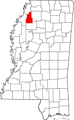
Quitman County, Mississippi Basics:


Quitman County Mississippi - Government Site

Population: 7,798
Area: 405 square miles
County seat: Marks
Area code(s) in use: 662
Time zone: CST
High school graduate or higher: 67.0%
Bachelor's degree or higher: 11.8%
Median household income: $23,115
Persons in poverty: 37.8%
Home ownership rate: 66.1%
Mean travel time to work: 22.5 minutes


Adjacent counties:
Coahoma  Panola  Tallahatchie  Tunica  
Find in Mississippi

Map of the Quitman County area


Our detail map of Quitman County shows the Quitman County, Mississippi boundary lines and other interesting items.

Places in Quitman County, Mississippi

  Airports     show all on map

Selfs Airport

  Bends     show all on map

Agar Lake Cut-Off, Blue Lake Cut-Off, Campbell White Cut-Off, Horseshoe Lake Cut -Off, Island Lake Cut-Off, Marks Cut-Off, Morning Star Cut-Off, Oxbow Bend, White Lake Cut -Off, Willow Lake Cut-Off, Wright School Cut-Off

  Bridges     show all on map

Mud Bridge

  Buildings     show all on map

Crowder Fire Department, Lambert Volunteer Fire Department Station 1 Headquarters, Lambert Volunteer Fire Department Station 2, Marks Fire Department Station 1 Headquarters, Marks Fire Department Station 2, Sledge Volunteer Fire Department

  Canals     show all on map

Panola Quitman Floodway, Pompey Ditch, Quitman Panola Ditch

  Cemeteries     show all on map

Belen Cemetery, Bower Cemetery, Chrestman Cemetery, Denton Cemetery, Gleason Grove Cemetery, Lambert Cemetery, New Macedonia Cemetery, Posey Mound Cemetery, Tallahatchie County Cemetery, Youngs Cemetery

  Census     show all on map

Darling Census Designated Place

  Churches     show all on map

Alexander Church, Allens Chapel (historical), Anderson Chapel, Beautiful Zion Church, Belen Baptist Church, Belmont Church, Belview Church, Bethel Church, Blue Lake Baptist Church, Blue Lake Chapel, Butler Chapel (historical), Cedar Grove Church (historical), Church of Christ (historical), Cinders Band Church (historical), Clear Creek Church, Cypress Church (historical), Dickerson Chapel, Eagle Grove Church, Fairhaven Church, First Baptist Church of Lambert, First Baptist Church of Marks, First Baptist Church of Sledge, Fish Lake Church, Friendship Church, Friendship Church, Gleason Grove Church, Goodwill Church, Greenhill Church, Holly Grove Church, Hollywood Church, James Church, Johnson Church (historical), Jones Chapel, Locke Station Church, Macedonia Chapel, Macedonia Church, Macedonia Church, Macedonia Church, Macedonia Church, Marks Church of Christ, Marks Presbyterian Church, Marks United Methodist Church, McNeil Church, Miller Church, Morning Star Church, Mount Eva Church, Mount Kingdom Church (historical), Mount Moriah Church (historical), Mount Nemo Church, Mount Olive Church, Mount Olive Church (historical), Mount Zion Church, Mount Zion Church, Neals Chapel, New Bethel Church, New Bethel Church, New Galilee Church, New Home Church, New Hope Church, New Light Church (historical), New Macedonia Church, New Mount Carmel Church, New Salem Church, New Salem Church (historical), Oak Grove Church, Pawpaw Church, Phillips Chapel, Pilgrims Rest Church, Pilgrims Rest Church, Pleasant Grove Church (historical), Pleasant Ridge Church, Queen Chapel, Riverside Church, Riverview Church, Robinson Chapel, Saint John Church, Saint John Church (historical), Saint John Church (historical), Saint Paul Church (historical), Sanctified Church, Shady Grove Church, Shady Grove Church, Shelton Grove Church, Silent Grove Baptist Church, Smith Chapel, Sturdevant Chapel (historical), Sykes Church, Tabernacle Church, Union Grove Church (historical), Valley Queen Missionary Baptist Church, Visitor Chapel, Walkers Chapel, Wallace Chapel (historical), Walnut Baptist Church, Wesley Chapel, West Marks Church, Whites Chapel, Whiting Chapel (historical), Woodland Chapel

  Crossings     show all on map

Neels Ferry, Turner Ferry (historical)

  Dams     show all on map

Harvey Howze Pond Dam, Tony Sabravati Lake Dam

  Guts     show all on map

Ash Log Bayou, Buck Bayou, Wilson Bayou

  Hospitals     show all on map

Quitman County Hospital

  Lakes     show all on map

Algar Lake, Bear Lake, Black Lake, Blue Hole, Blue Lake, Boyce Lake, Buckskin Lake, Buford Lake, Clear Lake, Croudip Lake, Dorsey Lake, Fish Lake, Flag Lake, Forked Lake, Grassy Lake, Hornet Lake, Horseshoe Lake, Island Lake, Little Whiting Lake, Locust Lake, Long Lake, Long Lake, McNeil Lake, Mussel Lake, Newsome Lakes, Oxbow Lake, Pecan Lake, Peterson Lake, Pompey Lake, Pruit Lake, Red Lake, Round Hole (historical), Shanker Lake, South Lake, Squirrel Lake, Twin Lakes, Whiting Lake, Whitney Lake, Willow Lake, Wilson Lake

  Locales     show all on map

Burgess (historical), Carr (historical), Dry Bayou Plantation, Green River (historical), Hazelwood (historical), Hills Precinct (historical), Keefe (historical), Mouth of Coldwater (historical), Oxbows Landing (historical), Pages (historical), Posey Mound, Quitman County Farm (historical), Quitman County Hunting Club (historical), State Penal Farm Camp B, Turner Landing (historical)

  Populated Places     show all on map

Allen, Barksdale, Belen, Birdie, Bobo, Chancy, Crenshaw, Crowder, Darling, Denton, Essex, Falcon, Hinchcliff, Lambert, Longstreet, Marks, Oliverfried, Riverview, Sabino, Sledge, Vance, Walnut, West Marks, Yarbrough

  Schools     show all on map

Arkadelphia School (historical), Avant School (historical), Bellview School (historical), Camal White School (historical), Crowder Elementary School, Crowder High School, Falcon School, Friendship School (historical), Gleason School (historical), Griffin School (historical), Holly Grove School (historical), Lambert High School, Miller School (historical), Mount Zion School (historical), New Bethel School (historical), Quitman County High School, Quitman County Industrial High School, Riverview School (historical), Sabino School (historical), Sledge Elementary School, Sledge High School, Southside School, Walnut School (historical), Westside School, Whiting School (historical), Wright School (historical)

  Streams     show all on map

Beech Bayou, Bobo Bayou, Broad Bayou, Brushy Bayou, Burrell Bayou, Coldwater River, David Bayou, Dry Bayou, Fish Bayou, Fourmile Bayou, Fourmile Bayou, Fowler Creek, Graveyard Bayou, Hope Bayou, Indian Creek, Little Opossum Bayou, Loggie Bayou, McNeil Bayou, Meyers Bayou, Moore Bayou, Muddy Bayou, Old Little Tallahatchie River, Old Yocona River, Onemile Bayou, Pecan Bayou, Puncheon Bayou, Sledge Bayou, Stovall Bayou, Thomasson Bayou, Tucker Bayou, Walnut Bayou, Whiting Chute, Yellow Lake Bayou

  Swamps     show all on map

Beaver Ruin Brake, Burnt Brake, Chinquapin Brake, Lost Lake, Whiting Brake

  Towers     show all on map

WQMA-AM (Marks),

Quitman County, Mississippi Population By Race (2012 estimate)

RacePopulation
BlackQuitman County Black population 5,3965,396  
WhiteQuitman County White population 2,2932,292
MixedQuitman County Mixed population 7877
American IndianQuitman County American Indian population 1615
Hawaiian & Pacific IslanderQuitman County Hawaiian & Pacific Islander population 00

Additional population tables :
State population table
Mississippi population by county