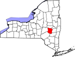
Schoharie County, New York Basics:


Schoharie County New York - Government Site

Population: 32,087
Area: 622 square miles
County seat: Schoharie
Area code(s) in use: 518 607
Time zone: EST
High school graduate or higher: 87.7%
Bachelor's degree or higher: 19.9%
Median household income: $51,896
Persons in poverty: 11.1%
Home ownership rate: 77.1%
Mean travel time to work: 28.0 minutes


Adjacent counties:
Albany  Delaware  Greene  Montgomery  Otsego  Schenectady  
Find in New York

Map of the Schoharie County area


Our detail map of Schoharie County shows the Schoharie County, New York boundary lines and other interesting items.

Places in Schoharie County, New York

  Airports     show all on map

B/G Heliport, Blue Heron Airport, Boyle's Landing Airport, Gar Field Airport, Hogan Airport, Nettie's Place Airport, Schoharie Creek Airport, Sharon Airport, Valley View Airport

  Bridges     show all on map

Blenheim Covered Bridge, Bridge Street Bridge, Cobleskill Creek Bridge, Cobleskill Creek Bridge, Delaware and Hudson Railroad Bridge, Howes Cave Road Bridge, Schoharie Bridge

  Buildings     show all on map

Alumni Hall, Blenheim Hose Company, Bouck Hall, Broome Volunteer Fire Department, Camp Summit (historical), Carlisle Volunteer Fire Department, Central Bridge Fire Department, Champlin Dining Hall, Charlotteville Volunteer Fire Department, Cobleskill Fire Department, Cobleskill Town Hall, Conesville Town Hall, Davis Hall, Dix Hall, Draper Hall, Esperance Fire Department, Esperance Town Hall, Fake Hall, Frisbie Hall, Gallupville Volunteer Fire Department, Hodder Hall, Huntersland Volunteer Fire Department, Iroquois Museum, Jefferson Town Hall, Jefferson Volunteer Fire Department, Knapp Hall, Kniskern House, Marchand Manor Assisted Living Facility, Middleburgh Emergency Volunteer Ambulance Corps, Middleburgh Fire Department, Middleburgh Library, Old Stone Fort Museum, Parsons Hall, Pearson Hall, Porter Hall, Prentice Dining Hall, Richmondville Fire House, Richmondville Volunteer Emergency Squad, Ryder Hall, Scho - Wright Ambulance Service, Schoharie Fire Department, Schoharie Free Library, Schoharie Valley Grange, Sharon Springs Free Library, Sharon Springs Joint Fire District, Sharon Springs Manor Adult Home, Summit Town Hall, Summit Volunteer Fire Department, Ten Eyck Hall, Van Wagenen Library, Vroman Hall, West Fulton Volunteer Fire Department, Wheeler Hall, Wieting Hall

  Cemeteries     show all on map

Abbott Cemetery, Argusville Cemetery, Argusville Cemetery, Armlin Cemetery, Ball Cemetery, Baptist Church Cemetery, Barkman Cemetery, Barkman Cemetery, Barton Hill Cemetery, Bates Hollow Church Cemetery, Beekman Cemetery, Bellinger Cemetery, Bile Cemetery, Blenheim Hill Cemetery, Borthwick Cemetery, Bradt Cemetery, Bramanville Cemetery, Breakabeen Cemetery, Burhans Cemetery, Carlisle Cemetery, Casper Cemetery, Central Bridge Cemetery, Chambers Cemetery, Champlin Cemetery, Charlotteville Cemetery, Choate Cemetery, Clapper Cemetery, Clock Cemetery, Cobleskill Rural Cemetery, Cotton Hill Cemetery, Cowley Cemetery, Dorloo Cemetery, Dugway Cemetery, East Conesville Cemetery, Ellis Cemetery, Ellis Cemetery, Ellison Cemetery, Esperance Cemetery, Evergreen Cemetery, Fox Cemetery, Fox-Cross Cemetery, France Cemetery, Franklinton Cemetery, Freese Cemetery, Fulton Hill Cemetery, Gallupville Rural Cemetery, Gilboa Rural Cemetery, Grovernors Corners Cemetery, Guernsey Cemetery, Hager Cemetery, Holmes Cemetery, Holy Cross Cemetery, Houck Cemetery, Huntersland Cemetery, Huntersland School Cemetery, Hynds Cemetery, Jefferson Old Village Cemetery, Keyser Cemetery, Kilmer Cemetery, Knisker Cemetery, Lawyer Cemetery, Lawyersville Cemetery, Leesville Cemetery, Livingston Presbyterian Cemetery, Livingstonville Cemetery, Lutheranville Cemetery, Manorkill Rural Cemetery, Marcley Cemetery, Mattice Cemetery, Maynard Cemetery, Methodist Church Cemetery, Moore Cemetery, New Eminence Cemetery, New Rhinebeck Cemetery, New Summit Cemetery, Old Eminence Cemetery, Old Stone Fort Cemetery, Old Summit Cemetery, Patria Cemetery, Patrie Cemetery, Peck Cemetery, Peoples Cemetery, Potter Hill Cemetery, Richmondville Rural Cemetery, Richmondville Village Cemetery, Richtmyer Case Cemetery, Rossman Cemetery, Ruliffson Cemetery, Safford Cemetery, Sagendorf Cemetery, Saint Pauls Cemetery, Scott Cemetery, Scott Patent Cemetery, Seward Cemetery, Shafer Cemetery, Shafer Cemetery, Shew Cemetery, Shultas Cemetery, Slate Hill Cemetery, Slingerland Cemetery, Sloansville Valley Cemetery, Snooks Cemetery, Soule Cemetery, South Gilboa Cemetery, Strobeck Cemetery, Taylor Cemetery, Village of West Fulton Cemetery, Warnerville Cemetery, Welch's Corners Cemetery, West Conesville Cemetery, West Jefferson Cemetery, West Richmondville Cemetery, Zimmer Cemetery

  Census     show all on map

Central Bridge Census Designated Place

  Churches     show all on map

Brimstone Church, Dutch Reformed Church, East Hill Church, Fairland Church, Gates Hill Church, Mountainview Church, Open Bible Baptist Church, Pilgrim Holiness Church, Reformed Church of Middleburgh, Reformed Church of Schoharie, Rhema Worship Center, Richmondville United Methodist Church, Rose of Sharon Church of God, Saint Anna's Catholic Church, Saint Catherines Roman Catholic Church, Saint Christopher Episcopal Church, Saint Johns Church, Saint Mark's Lutheran Church, Saint Matthew's Lutheran Chapel, Saint Paul's Lutheran Church, Schoharie Valley Alliance Church, Scott Patent Church, Sharon Springs United Methodist Church, Summit United Methodist Church, Trinity Lutheran Church, United Methodist Church, United Presbyterian Church, Zion Evangelical Lutheran Church, Zion Lutheran Church of Seward

  Cliffs     show all on map

The Cliff, Vromans Nose

  Dams     show all on map

Gilboa Dam

  Falls     show all on map

Boucks Falls, Manorkill Falls, Mine Kill Falls

  Hospitals     show all on map

Beard Wellness Center, Cobleskill Regional Hospital

  Islands     show all on map

Boucks Island

  Lakes     show all on map

Baldwin Pond, Bowmaker Pond, Clausen Pond, Fly Pond, Fuller Pond, Mud Lake, Rossman Pond, Russell Lake, Summit Lake, The Vlaie

  Locales     show all on map

Baird Corners, Barbers Farm, Becker Corners, Beekman Corners, Bohringers Fruit Farm, Buck Hill Farm, Clay Hill Farm, Cobleskill Drive-In (historical), Cobleskill Golf and Country Club, Cobleskill Village Water Pollution Control Plant, Cold Springs Farm, Cooper's Ark Farm, Country Road Campground, Five Corners, Foundation Equestrian Center, Fran Lan Farms, George Landis Arboretum, Heather Ridge Farm, Hide - a - Way Campsites, Highwinds Farm, Housons Corners, Mountainview Paradise Golf Estate, Nagimor Farm, Nickerson Park Campground, Old Stone Fort, Parsons Farm, Red Maple Farm, Ruth, Sagendorf Corners, Schoharie Valley Railroad Complex, Sharon Orchards, Shutts Corners, Sidney Corners, Stone House Farm, Sunnycrest Orchards Farm Market, Terrace Mountain Orchard, Vroman Corners, Welch Corners, Zeh Corners

  Mines     show all on map

Cobleskill Quarry, Klondike Quarry, Schoharie Quarry

  Parks     show all on map

Central Bridge Community Park, Crittenden Athletic Fields, Fox Creek Park, Lasalle Park, Max V Shaul State Park, Mine Kill State Park

  Populated Places     show all on map

Arabia, Argusville, Barnerville, Bates, Beards Hollow, Bramanville, Breakabeen, Broome Center, Carlisle, Carlisle Center, Central Bridge, Charlotteville, Clove, Cobleskill, Colonial Village Mobile Home Park, Conesville, Dorloo, Dwelly Corners, East Cobleskill, East Jefferson, Eminence, Engleville, Esperance, Flat Creek, Franklinton, Fultonham, Gallupville, Gardnersville, Gilbert Corners, Gilboa, Greenbush, Grovenor Corners, Hawversville, Howes Cave, Huntersland, Hyndsville, Janesville, Jefferson, Lawyersville, Leesville, Lincoln Mobile Home Park, Little York, Livingstonville, Lutheranville, Mackey, Manorkill, Middleburgh, Mineral Springs, North Blenheim, Old Central Bridge, Owlsville, Patria, Pine Grove, Richmondville, Schoharie, Schoharie Junction, Seward, Sharon, Sharon Center, Sharon Springs, Shutter Corners, Sloansville, South Gilboa, South Gilboa Station, South Jefferson, Staleyville, Summit, Valley Mobile Home Court, Valley Mobile Home Court, Vintonton, Vorman Corners, Warnerville, Watsonville, West Conesville, West Fulton, West Jefferson, West Middleburgh, West Richmondville

  Post Offices     show all on map

Charlotteville Post Office, Fultonham Post Office, Jefferson Post Office, North Blenheim Post Office, Schoharie Post Office, Sloansville Post Office, Summit Post Office, West Fulton Post Office

  Reservoirs     show all on map

Bear Gulch Pond, Blenheim Gilboa Reservoir, Cobleskill Reservoir, Conover Pond, Echo Pond, Engleville Pond, Mayham Pond, Schoharie Reservoir, Stamford Reservoir, Upper Blenheim Gilboa Reservoir, Utsayantha Lake

  Ridges     show all on map

Dutton Ridge, Windy Ridge

  Schools     show all on map

Barton Hill School (historical), Bridge School, Central School, Clapper Hollow School (historical), Cobleskill - Richmondville High School, Cross Hill School, Fuller District School Number Four (historical), George D Ryder Elementary School, Hicks School, Jefferson Central School, Joseph B Radez Elementary School, Lamb of God Christian School, Middleburgh Central School, Middleburgh Elementary School, Oliver School (historical), Petty School, Saint Mark's Christian School, Schoharie County High School, Schoharie Elementary School, Schoharie Junction School (historical), Schoharie Occupational Education Center, School Number 1 (historical), School Number 1 (historical), School Number 10 (historical), School Number 10 (historical), School Number 11 (historical), School Number 11 (historical), School Number 12 (historical), School Number 12 (historical), School Number 12 (historical), School Number 12 (historical), School Number 13 (historical), School Number 13 (historical), School Number 13 (historical), School Number 14 (historical), School Number 14 (historical), School Number 14 (historical), School Number 14 (historical), School Number 15 (historical), School Number 2 (historical), School Number 2 (historical), School Number 2 (historical), School Number 2 (historical), School Number 3 (historical), School Number 3 (historical), School Number 4 (historical), School Number 4 (historical), School Number 4 (historical), School Number 4 (historical), School Number 5 (historical), School Number 5 (historical), School Number 5 (historical), School Number 5 (historical), School Number 5 (historical), School Number 6 (historical), School Number 6 (historical), School Number 6 (historical), School Number 6 (historical), School Number 6 (historical), School Number 7 (historical), School Number 7 (historical), School Number 7 (historical), School Number 7 (historical), School Number 8 (historical), School Number 8 (historical), School Number 8 (historical), School Number 9 (historical), School Number 9 (historical), School Number 9 (historical), School Number 9 (historical), School Number 9 (historical), School Number 9 (historical), School Number 9 (historical), Sharon Springs Central School, State University of New York College of Agriculture and Technology at Cobleskill, William H Golding Elementary School, William H Golding Middle School

  Streams     show all on map

Bear Kill, Betty Brook, Black Brook, Clapper Hollow Creek, Cobleskill Creek, Cole Brook, Cripplebush Creek, Fly Creek, Fox Creek, Heathen Creek, House Creek, Keyser Kill, King Creek, Lake Creek, Line Creek, Little Schoharie Creek, Louse Kill, Manor Kill, Mill Creek, Mine Kill, Ox Kill, Panther Creek, Platter Kill, Punch Kill, Stony Brook, Stony Creek, Stony Creek, West Creek, West Kill, Wharton Hollow Creek

  Summits     show all on map

Armlin Hill, Bald Mountain, Barrack Zourie, Barton Hill, Blenheim Hill, Blenheim Mountain, Bornt Hill, Brown Mountain, Bull Hill, Burnt Hill, Cannady Hill, Cotton Hill, Donats Mountain, East Hill, Fulton Hill, Gates Hill, High Knob, Hogback, Hony Hill, Hubbard Hill, Leonard Hill, Meade Hill, Mine Hill, Moore Hill, Mount Jefferson, Mount Royal, Mount Shank, Petersburg Mountain, Pine Hill, Pine Mountain, Quiery Hill, Reed Hill, Richtmyer Peak, Rossman Hill, Round Top, Rundy Cup Mountain, Safford Hill, Schoharie Hill, Scott Patent Hill, Sicklers Mountain, Steenburg Mountain, Stevens Mountain, Terrace Mountain, The Cobble, Towpath Mountain, Walhalla Rocks, Warnerville Hill, Wayman Hill, Welch Hill, Woodchuck Hill, Zimmer Hill

  Swamps     show all on map

Bear Swamp, Cedar Swamp

  Towers     show all on map

WMYY-FM (Schoharie), WSCM-AM (Cobleskill)

  Valleys     show all on map

Bear Gulch, Beards Hollow, Bouck Hollow, Brooker Hollow, Brookie Hollow, Clapper Hollow, Cole Hollow, Cornell Hollow, Darling Hollow, Dibble Hollow, Doney Hollow, Ecker Hollow, Laughton Hollow, Mickel Hollow, Mill Valley, Pleasant Valley, Sawyer Hollow, Shew Hollow, The Gorge, Warner Hollow, Wharton Hollow, Whiting Hollow,

Schoharie County, New York Population By Race (2012 estimate)

RacePopulation
WhiteSchoharie County White population 30,90030,899  
MixedSchoharie County Mixed population 417417
AsianSchoharie County Asian population 257256
American IndianSchoharie County American Indian population 9696
Hawaiian & Pacific IslanderSchoharie County Hawaiian & Pacific Islander population 00

Additional population tables :
State population table
New York population by county