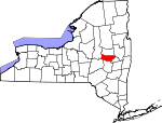
Montgomery County, New York Basics:


Montgomery County New York - Government Site

Population: 49,916
Area: 403 square miles
County seat: Fonda
Area code(s) in use: 518
Time zone: EST
High school graduate or higher: 83.5%
Bachelor's degree or higher: 16.1%
Median household income: $42,830
Persons in poverty: 19.2%
Home ownership rate: 67.8%
Mean travel time to work: 23.9 minutes


Adjacent counties:
Fulton  Herkimer  Otsego  Saratoga  Schenectady  Schoharie  
Find in New York

Map of the Montgomery County area


Our detail map of Montgomery County shows the Montgomery County, New York boundary lines and other interesting items.

Places in Montgomery County, New York

  Airports     show all on map

Amsterdam Airfield, Canajoharie Airport, Di Stefano Airpark, Hickory Acres Airport, Hiserts Airpark Inc, Hop House Airpark, Nellis Field Airport, O'Riley Airport, Russell Airport, Saint Marys Hospital Elevated Heliport, The Ranch Airport

  Bridges     show all on map

Barge Canal Bridge, Barge Canal Bridge, East Canada Creek Bridge, Florida Town Bridge, Irish Creek Bridge, Mohawk River Barge Canal Bridge, Mohawk River Bridge, North Chuctanunda Creek Bridge, Otsquago Creek Bridge, Schoharie Creek Bridge

  Buildings     show all on map

Ames Volunteer Fire Department, Amsterdam City Hall, Amsterdam Fire Department, Amsterdam Fire Station Number 3, Amsterdam Fire Station Number 4, Amsterdam Fire Station Number 5 (historical), Amsterdam Fire Station Number 6, Amsterdam Free Library, Amsterdam Memorial Hospital Skilled Nursing Facility, Amsterdam Public Safety Building, Arkell Museum, Canajoharie Library, Canajoharie Volunteer Fire Department, Charleston Volunteer Fire Department, Cranesville Volunteer Fire Department, Florida Volunteer Fire Department, Fort Hunter Engine and Hose Company, Fort Hunter Free Library, Fort Johnson Fire Company Station 1, Fort Plain Fire Department, Fort Plain Free Library, Frothingham Free Library, Glen Volunteer Fire Department, Greater Amsterdam Volunteer Ambulance Corps, Hagaman Volunteer Fire Department, Margaret Reaney Memorial Library, Mid County Volunteer Ambulance Service, Mohawk Volunteer Fire Department, Montgomery County Home (historical), Montgomery Meadows Residential Health Care Facility, Morris Building, Mount Loretto Nursing Home, Palatine Nursing Home, Park Hill Adult Home, Rialto Theatre, Saint Johnsville Family Health Center, Saint Johnsville Volunteer Ambulance Corps, Sarah Jane Sanford Home For Elderly Women

  Cemeteries     show all on map

Ames Cemetery, Caughnawaga Cemetery, Christian Church Cemetery, Chuctanunda Cemetery, Clouse Cemetery, Coleman Cemetery, County Line Cemetery, Crane Cemetery, Currytown Cemetery, Dillenback Cemetery, Dodds Cemetery, Dorn Cemetery, Dunkel Cemetery, Edwards Cemetery, Evergreen Cemetery, Fairview Cemetery, First Baptist Church Cemetery, Flanders Cemetery, Flint Cemetery, Flint Cemetery, Fort Plain Cemetery, Frey Bush Cemetery, Friends Cemetery, Good Shepherd Cemetery, Gove Cemetery, Green Cemetery, Green Cemetery, Green Hill Cemetery, Griffeth Cemetery, Hagaman Mills Cemetery, Haight Cemetery, Kimball Cemetery, Kline Cemetery, Klock Cemetery, Klock Cemetery, Lykers Cemetery, Maple Avenue Cemetery, Mapletown Cemetery, Mitchell Cemetery, Montgomery County Home Cemetery, Mount Carmel Cemetery, Mount Hope Cemetery, Nellis Cemetery, Nelliston Cemetery, Nestle Cemetery, Old Hagaman Cemetery, Old Saint Josephs Cemetery, Olmstead Cemetery, Palatine Bridge Cemetery, Phillips Cemetery, Phillips Cemetery, Pine Grove Cemetery, Prospect Hill Cemetery, Prospect View Cemetery, Reformed Church Cemetery, Remsen Bush Cemetery, Saint Casimir Cemetery, Saint Johns Cemetery, Saint Josephs Cemetery, Saint Marys Cemetery, Saint Michael Cemetery, Saint Stanislaus Cemetery, Sammons Cemetery, Scotch Church Cemetery, Sitterly Cemetery, Sweet Cemetery, Thayer Cemetery, Van Epps-Starin Cemetery, Van Vechten Cemetery, Village Cemetery, Walrath Cemetery, West Saint Johnsville Cemetery, Wiles Cemetery, Wycoff Cemetery, Yerding Cemetery

  Census     show all on map

Tribes Hill Census Designated Place

  Churches     show all on map

Ames - Sprout Brook Methodist Church, Auriesville Shrine, Calvary Assembly of God Church, Calvary Reformed Church, Christian Church, Cranesville Reformed Church, Emanuel Presbyterian Church, Episcopal Church of the Good Shepherd, Evangelical United Brethren Church (historical), Family Bible Church, First Baptist Church, First Baptist Church, First Methodist Church, First Methodist Church, First Reformed Church, First Reformed Church, Fonda Reformed Church, Forest Avenue Methodist Church, Good Shepherd Church, Grace Christian Church, Holy Cross Episcopal Church, Kingdom Hall of Jehovahs Witnesses, Kingdom Hall of Jehovahs Witnesses, Kingdom Hall of Jehovahs Witnesses Amsterdam Congregation, Our Lady of Mount Carmel Church, Palatine Church, Pilgrim Holiness Church, Primera Iglesia Bautista de Amsterdam Baptist Church, Reparatrix Convent, Saint Ann's Episcopal Church, Saint Casimir's Roman Catholic Lithuanian Church, Saint Cecilia Church, Saint James Roman Catholic Church, Saint John The Baptist Roman Catholic Church, Saint John's Reformed Church, Saint Joseph Convent (historical), Saint Josephs Roman Catholic Church, Saint Lukes Lutheran Church, Saint Marys Roman Catholic Church, Saint Michael's Roman Catholic Church, Saint Nicholas Greek Catholic Church, Saint Paul Lutheran Church, Saint Pauls Lutheran Church, Saint Stanislaus Catholic Church, Saint Stephen's Catholic Church, Saving Grace Baptist Church, Second Presbyterian Church, Seventh Day Adventist Church, Tekakwitha Friary, Temple of Israel, Trinity Lutheran Church, Trinity Lutheran Church, Trinity Reformed Church, Valley Alliance Church

  Cliffs     show all on map

Big Nose, Little Nose

  Crossings     show all on map

Interchange 27, Interchange Number 28

  Dams     show all on map

Lock Number 10, Lock Number 11

  Falls     show all on map

Buttermilk Falls, Canajoharie Falls

  Flats     show all on map

Wintergreen Flats

  Hospitals     show all on map

Saint Mary's Healthcare Amsterdam Memorial Campus, Saint Mary's Hospital, Saint Mary's Hospital

  Islands     show all on map

Abeel Island, Bronson Island, Davey Island, Giording Island, Pepper Island, Robb Island, Swart Island, Upper Pepper Island

  Lakes     show all on map

Kellogg Pond, McLachlan Pond, Youngs Lakes

  Locales     show all on map

Amsterdam City Wastewater Treatment Plant, Amsterdam Golf Course, Amsterdam Industrial Center, Amsterdam Toll Plaza, Appleridge Farm, B and B Crop Farms, Bellinger's Apple Orchard, Canajoharie Country Club, Canajoharie Village Wastewater Treatment Plant, Canajoharie Village Water Filtration Plant, Canjoharie Toll Plaza, Cashins Farm, Christmans Corners, Clancy Farms, Currytown Farm, Damin Farm, Damrock Farm, Davis Corners, Featherwood Farm, Fonda - Fultonville Wastewater Treatment Plant, Fox Corners, Fultonville Toll Plaza, Holloway Brothers Farm, Kietzman Farm, Kilmartin Corners, Lib Corners, Longmeadow Farm, Market Corners, Merry Hill Farm, Mill Point, Mohawk Rest Area, Mohawk Ridge Farms, Montgomery County Sewer District 1 Sewage Treatment Plant, Moyers Corners, Natural Bridge Farm, Niagara-Mohawk Power Corporation Church Street Sub-Station, One Cow Farm, Pattersonville Rest Area, Pavlus Orchard, Persons Farm, Potter Farms, Ridgedale Farm, Ripple Corners, Rockwell Corners, Rolling Hills Country Club, Rulison Honey Farm, Saint Johnsville Village Wastewater Treatment Plant, Sand Flats Orchard, Snooks Corners, Square Barn Corners, Starlight Acres, Young Corners

  Military     show all on map

Amsterdam Armory, Fort Johnson (historical), Fort Klock (historical)

  Mines     show all on map

Saint Johnsville Quarry

  Parks     show all on map

Bergen Park, Coessens Park, Glen Historic District, Hassenfuss Field, Klock Park, Mohawk Mills Park, Nelliston Historic District, Schoharie Crossing State Historic Site, Veterans Memorial Field

  Pillars     show all on map

Herkimer Monument

  Populated Places     show all on map

Ames, Amsterdam, Auriesville, Berryville, Brookman Corners, Browns Hollow, Buel, Burtonsville, Canajoharie, Charleston, Charleston Four Corners, Charlesworth Corners, Church Corners, Cook Corners, Cranesville, Crescent Park, Currytown, East Stone Arabia, Edge of Town Mobile Home Park, Flat Creek, Fonda, Fordsbush, Fort Hunter, Fort Johnson, Fort Plain, Freysbush, Fultonville, Fultonville Mobile Home Park, Glen, Hagaman, Hallsville, Harrower, Hessville, Highland Mobile Home Estates, Keesler Corners, Lost Valley, Lykers, Manny Corners, Mapletown, Marshville, McKinley, Miller Corners, Minaville, Mindenville, Nelliston, Oak Ridge, Palatine Bridge, Pine Meadow Mobile Home Park, Randall, Rockton, Root Center, Rural Grove, Saint Johnsville, Salt Springville, Sand Hill, Scotch Bush, Scotch Church, Shady Lane Mobile Home Park, South Amsterdam, Sprakers, Sprout Brook, Stone Arabia, Stone Ridge, Tribes Hill, Valley Brook, Van Deusenville, Wallins Corners, Waterville, Wellsville, West Saint Johnsville, Yosts

  Post Offices     show all on map

Amsterdam Post Office, Canajoharie Post Office, Fonda Post Office, Fort Hunter Post Office, Fort Johnson Post Office, Fort Plain Post Office, Fultonville Post Office, Hagaman Post Office, Nelliston Post Office, Palatine Bridge Post Office, Saint Johnsville Post Office, Sprakers Post Office, Tribes Hill Post Office

  Reservoirs     show all on map

Canajoharie Reservoir, Fonda Reservoir, Fort Plains Reservoir, Harrower Pond, Kellogg Reservoir, Old Fonda Reservoir, Palatine Bridge Underground Reservoir

  Schools     show all on map

Academy Street School, Ames Academy (historical), Amsterdam High School, Arnold Avenue School, Bonesteel School (historical), Bratt School (historical), Buckler Christian Academy, Burtonsville School, Cadaughrity School, Canajoharie Middle School, Canajoharie Senior High School, Carytown School, Clara S Bacon Elementary School (historical), Collins Corners School, Corbin Hill School (historical), Cranes Hollow School, David H Robbins Elementary School, District Number 3 School (historical), District Number 9 School (historical), Dutchtown School, East Hill School, East Main Street School, Fifth Ward School, Fonda - Fultonville K - 4 School, Fonda - Fultonville Senior High School, Fonda-Fultonville 5 - 8 School, Fort Plain Central School, Fort Plank School, Free Union School (historical), Gray School, Guy Park Avenue School, Hamilton School (historical), Harry Hoag Elementary School, Hickory Hill School (historical), Kline School, Klock School, Maloney School (historical), Marie Curie Institute of Engineering and Commerce, McCleary School, Meadow Brook School, Milton Avenue School, Mountanye School, Nellis Center School (historical), Nelliston Public School (historical), Nestle School (historical), R J McNulty Academy, River Road School, Saint Johnsville Junior - Senior High School, Saint Josephs Parochial School, Saint Mary's Catholic Institute (historical), Saint Mary's Institute Elementary School, Saint Marys Hospital School of Nursing, Saint Stanislaus School, School Number 10 (historical), School Number 10 (historical), School Number 10 (historical), School Number 11 (historical), School Number 11 (historical), School Number 12 (historical), School Number 13 (historical), School Number 13 (historical), School Number 14 (historical), School Number 15 (historical), School Number 17 (historical), School Number 2 (historical), School Number 2 (historical), School Number 3 (historical), School Number 3 (historical), School Number 3 (historical), School Number 4 (historical), School Number 4 (historical), School Number 4 (historical), School Number 4 (historical), School Number 5 (historical), School Number 5 (historical), School Number 5 (historical), School Number 6 (historical), School Number 6 (historical), School Number 6 (historical), School Number 7 (historical), School Number 7 (historical), School Number 7 (historical), School Number 7 (historical), School Number 7 (historical), School Number 7 (historical), School Number 8 (historical), School Number 8 (historical), School Number 9 (historical), School Number 9 (historical), Seeber Lane School, Swart Hill School, Switzer Hill School, Theodore Roosevelt Junior High School, Victory Christian Academy, Voorhees School, Vrooman Avenue School, Walts School, West Hill School (historical), West Spring Street School, Wilbur Lynch High School, William B Tecler Elementary School, William Barkley School, Winnie School (historical), Woodrow Wilson School, Yankee Hill School

  Streams     show all on map

Auries Creek, Bowmans Creek, Briggs Run, Brimstone Creek, Bunn Creek, Canajoharie Creek, Caroga Creek, Compaanen Kill, Crum Creek, Danascara Creek, Degraff Creek, Dove Creek, East Canada Creek, Evas Kill, Flat Creek, Flitzpatrick Creek, Irish Creek, Kayaderosseras Creek, Knauderack Creek, Lasher Creek, McQueen Creek, Mill Creek, Mother Creek, Otsquago Creek, Revine Creek, Schoharie Creek, South Chuctanunda Creek, Terwilleger Creek, Timmerman Creek, Van Wie Creek, Wilsey Creek, Yatesville Creek, Zimmerman Creek

  Summits     show all on map

Bean Hill, Budd Hill, Corbin Hill, Failing Hill, Florida Hills, Maple Hill, McKinney Hill, Patton Hill, Round Top, Shellstone Hill, Swart Hill, Wessel Hill

  Swamps     show all on map

Little Bear Swamp

  Towers     show all on map

WBUG-AM (Amsterdam), WCAN-FM (Canajoharie), WCSS-AM (Amsterdam), WSHQ-FM (Cobleskill)

  Valleys     show all on map

Cranes Hollow, Happy Hollow, Hell Hollow, Mudge Hollow, Wagner Hollow,

Montgomery County, New York Population By Race (2012 estimate)

RacePopulation
WhiteMontgomery County White population 47,17147,170  
BlackMontgomery County Black population 1,2481,247
MixedMontgomery County Mixed population 799798
AsianMontgomery County Asian population 399399
American IndianMontgomery County American Indian population 250249
Hawaiian & Pacific IslanderMontgomery County Hawaiian & Pacific Islander population 5049

Additional population tables :
State population table
New York population by county