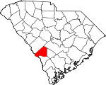
Barnwell County, South Carolina Basics:


Barnwell County South Carolina - Government Site

Population: 22,271
Area: 548 square miles
County seat: Barnwell
Area code(s) in use: 803
Time zone: EST
High school graduate or higher: 79.1%
Bachelor's degree or higher: 12.2%
Median household income: $35,748
Persons in poverty: 28.7%
Home ownership rate: 74.3%
Mean travel time to work: 24.5 minutes


Adjacent counties:
Aiken  Allendale  Bamberg  Burke (GA)  Orangeburg  

Find in South Carolina

Map of the Barnwell County area


Our detail map of Barnwell County shows the Barnwell County, South Carolina boundary lines and other interesting items.

Places in Barnwell County, South Carolina

  Airports     show all on map

Barnwell Regional Airport

  Areas     show all on map

Slaughter Field

  Bridges     show all on map

Beaverdam Bridge, Pattersons Bridge

  Buildings     show all on map

Barnwell County Emergency Management Office, Barnwell County Fire Coordinator, Barnwell County Fire Department, Barnwell County Library, Barnwell County Sheriff's Office, Barnwell Fire Department, Barnwell Police Department, Barnwell Rural Fire Department, Blackville Fire Department, Elko Volunteer Fire Department Elko, Friendship Volunteer Fire Department, Hilda Volunteer Fire Department, Kline Volunteer Fire Department, Long Branch Rural Fire Department, Pump House Number 5, Pump House Number 6, Red Oak Volunteer Fire Department, Snelling Volunteer Fire Department, South Carolina State Government Law Enforcement Office, Williston Fire Department, Williston Police Department, Williston Rescue Squad

  Capes     show all on map

Bannon Point, Flowers Point

  Cemeteries     show all on map

Bates Cemetery, County Memory Gardens, Dunbar Cemetery, Frost Branch Cemetery, Hair Cemetery, Holmes Cemetery, Hope Memorial Park, Jowers Cemetery, Jowers Cemetery, Old Field Cemetery, Sanders Cemetery, Scott Cemetery, Seven Pines Cemetery, Singleton Cemetery, Walker Cemetery, Williams Cemetery, Williams Cemetery, Woods Cemetery, Woods Cemetery

  Churches     show all on map

Allens Chapel Baptist Church, Ashleigh Baptist Church, Ashleigh Church (historical), Ashleigh Church (historical), Barnwell Mennonite Church, Barnwell Presbyterian Church, Barnwell United Methodist Church, Bell Pond Baptist Church, Bethlehem Baptist Church, Big Fork Church (historical), Blackville Church (historical), Blackville United Methodist Church, Boiling Springs Presbyterian Church, Browns Church, Calvary Church, Canaan Church (historical), Canaan Fair Church, Chaney Grove Church (historical), Church of God, Church of God, Church of God, Daisy May Church (historical), Double Pond Baptist Church, Ebenezer Baptist Church, Ebenezer Baptist Church, Elko Baptist Church, Episcopal Church of the Holy Apostles, Fair Branch Church (historical), Fairmont Church (historical), First Assembly of God Church, First Baptist Church, First Baptist Church, First Baptist Church, Foster Branch Church (historical), Four Mile Church (historical), Friendship Baptist Church, Friendship Baptist Church, Friendship Church (historical), Frost Branch Baptist Church, Gospel Mission, Great Cypress Baptist Church, Green Branch Church, Grubbs Mission, Hagood Avenue Baptist Church, Healing Springs Baptist Church, Hutto Chapel Baptist Church, Jordan Baptist Church, Joyce Branch Church (historical), Kline Baptist Church, Long Branch Baptist Church, Macedonia Baptist Church, Mission Church (historical), Morris Chapel, Morris Chapel (historical), Mount Calvary Church, Mount Lebanon Church, Mount Olivet Baptist Church, Neds Branch Church (historical), New Home Baptist Church, New Jerusalem Baptist Church, Nobel Street Baptist Church, Parks Church (historical), Pilgrim Rest Baptist Church, Pine Hill Church, Pleasant Hill Church (historical), Pleasant Mount Church (historical), Red Branch Baptist Church, Reedy Branch Baptist Church, Rosemary Baptist Church, Rosemary Baptist Church, Rosemary Church, Sacred Heart Church, Saint Albans Church, Saint Andrews Roman Catholic Church, Saint Johns Baptist Church, Saint Luke Church (historical), Saint Marys Church, Saint Paul Baptist Church, Saint Paul Church (historical), Saint Peter Baptist Church, Saint Peters Church (historical), Second Baptist Church, Second Mount Olive Baptist Church, Seven Pines Baptist Church, Seven Pines Church (historical), Shiloh Church (historical), Shrub Branch Church, Siloam Church, Silver Spring Church, Spring Branch Church (historical), Springfield Baptist Church, Steel Creek Church (historical), Sunshine Baptist Church, Sweet Branch Baptist Church, Sweetwater Grove Church, Temple Baptist Church, Thomas Grove Church (historical), Thomas Grove Church (historical), Union Branch Church (historical), Union Church, Union Church, Williston Presbyterian Church, Winfield Heights Baptist Church, Zion Grove Church (historical)

  Crossings     show all on map

Dog Ferry (historical)

  Dams     show all on map

Andersons Pond D-3059 Dam, Bates Pond D-3072 Dam, Bolens Fishing Lake D-3063 Dam, Bolens Pond D-3055 Dam, Collums Pond D-3071 Dam, Dicks Pond D-3069 Dam, Edgar A Brown Dam D-3064, Edisto Pond Dam D-3061, Folks Lower Pond D-3053 Dam, Folks Upper Pond Dam D-3052, Fuller Pond Dam D-3065, Hairs Pond D-3060 Dam, Handberry Pond Dam D-3066, Hartzogs Pond Dam D-3056, Jowers Pond Dam D-3048, Lake Cynthia Dam D-3068, Matthews Mill Pond D-3049 Dam, McLains Pond D-3058 Dam, Mixon Pond Dam D-3051, Owens Pond D-3067 Dam, Redds Pond D-3050 Dam, Savannah River Plant Pond B D-3078 Dam, Savannah River Plant Pond Dam Number Five D-3076, Savannah River Plant Pond Dam Number Four D-3075, Savannah River Plant Pond Number Two D-3074 Dam, Srp Number 16-403-D D-3073 Dam, Srp Number 18-488-10 D-3077 Dam, Stills Pond D-3057 Dam, W C Smiths Pond D-3070 Dam, Willis Mill Pond D-3054 Dam

  Forests     show all on map

Ernest Rand Memorial State Forest

  Hospitals     show all on map

Barnwell County Hospital

  Lakes     show all on map

Buckmire Pond (historical), Craigs Pond, Cypress Pond (historical), Fiddle Pond, Folk Pond, Guess Pond, Kennedys Pond, Lake Brown, Nicks Lake (historical), Peters Pond, Pond Four, Pond Two, Sister Lake

  Locales     show all on map

Barnwell Station (historical), Bells Mill (historical), Boylston Mill (historical), Brinleys Mill (historical), Carter Plaza Shopping Center, Dunbarton Fire Tower, Edisto Experimental Station, Ellis Store (historical), Griffins Store (historical), Iris Hall, Meyers Mill (historical), Meyers Mill Siding, Robbins Station, Sanders Old Mill (historical), Short Staple Plantation (historical), Stringfellows Mill (historical), Substation Number 3, Thalmans Mill (historical), Tri-County Shopping Center, Willis Mill (historical), Woodward Mill (historical)

  Military     show all on map

Barnwell Army Air Field (historical)

  Parks     show all on map

Barnwell State Park

  Populated Places     show all on map

Ashleigh, Ashley Place (historical), Barnwell, Blackville, Boiling Springs, Donora (historical), Dunbarton (historical), Elko, Ellenton (historical), Farrells Mill, Greenland (historical), Guiomaer (historical), Hagoods Mill, Happy Bottom, Hattieville, Healing Springs, Hells Half Acre, Hilda, Kline, Leigh (historical), Long Branch, Owens Crossroad, Patterson Mill, Reynold, Robbins (historical), Rosemary (historical), Snelling, Walker, Whaley, Williston, Yale (historical), Yenome

  Post Offices     show all on map

Barnwell Post Office, Blackville Post Office, Hilda Post Office

  Reservoirs     show all on map

Bolen Pond, Castles Pond (historical), Corleys Mill Pond (historical), Edgar A Brown Lake, Fuller Pond, Hayes Mill Pond, Lake Cynthia, Matthews Millpond, Par Pond, Pond B, Pond Five, Stringfellow Mill Pond, Willis Millpond

  Schools     show all on map

Ashleigh School (historical), Ashleigh School (historical), Ashley Grove School (historical), Barbers Branch School, Barnwell Academy (historical), Barnwell Elementary School, Barnwell High School, Bell Pond School (historical), Big Forks School (historical), Blackville High School, Blackville Middle School, Blackville School (historical), Blessed Home School (historical), Boiling Spring School (historical), Browns School (historical), Calvary School (historical), Cedar Grove School (historical), Craig Pond School (historical), Diamond School (historical), Double Pond School (historical), Dry Branch School (historical), Ebenezer School (historical), Edwards Junior High School, Fair Branch School (historical), Four Mile School (historical), Friendship School (historical), Frost Branch School (historical), Galilee School (historical), Great Cypress School (historical), Green Branch School (historical), Greenland School (historical), Greens Academy School (historical), Gum Pond School (historical), Hailey Branch School (historical), Healing Spring School (historical), Hercules School (historical), Jefferson Davis Academy, Jordan School (historical), Long Branch School (historical), Long Branch School (historical), Macedonia Middle School, Morris Chapel School (historical), Morris School (historical), Morris School (historical), Mount Pleasant School (historical), Neds Branch School (historical), Oak Grove School, Opossum College (historical), Park School (historical), Patterson Mill School (historical), Pleasant Hill School (historical), Reedy Branch School (historical), Reese Creek School (historical), Rosemary School, Rosemary School (historical), Roundtree School (historical), Saint John School (historical), Saint Marys School (historical), Saint Matthews School (historical), Saint Paul School (historical), Saint Peters School (historical), Shrub Branch School (historical), Silver Spring School (historical), Spring Branch School (historical), Steel Creek School (historical), Sunshine School (historical), Sunshine School (historical), Sweet Branch School (historical), Thomas Grove School (historical), Tinkers Creek School (historical), Union Branch School (historical), Williston-Elko High School, Williston-Elko Middle School, Yaw Branch School (historical)

  Springs     show all on map

Boiling Spring, Healing Springs, White Oak Spring

  Streams     show all on map

Big Branch, Bodiford Mill Creek, Boggy Gut Branch, Buck Creek, Caddins Branch, Dry Branch, Fourmile Branch, Gantts Mill Creek, Georges Creek, Gideon Branch, Hercules Creek, Hurricane Creek, Indian Grave Branch, Jordan Branch, Joyce Branch, Long Branch, Meyers Branch, Mill Creek, Parker Branch, Patterson Branch, Pen Branch, Reedy Branch, Riley Mill Branch, Rosemary Creek, Sheepford Branch, Shrub Branch, Spur Branch, Steel Creek, Toby Creek, Turkey Creek, Whaley Creek, Windy Hill Creek, Yarrow Branch

  Summits     show all on map

Barnwell Hill

  Swamps     show all on map

Booker Pond, Ditch Pond, Duck Pond, Duck Pond Bay, Green Savannah Lake, Little Wolf Bay, Wolf Bay

  Towers     show all on map

WBAW-AM (Barnwell), WBAW-FM (Barnwell), WEBA-TV (Allendale),

Barnwell County, South Carolina Population By Race (2012 estimate)

RacePopulation
WhiteBarnwell County White population 11,84811,848  
BlackBarnwell County Black population 9,8669,866
MixedBarnwell County Mixed population 334334
AsianBarnwell County Asian population 134133
American IndianBarnwell County American Indian population 111111
Hawaiian & Pacific IslanderBarnwell County Hawaiian & Pacific Islander population 00

Additional population tables :
State population table
South Carolina population by county