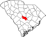
Calhoun County, South Carolina Basics:


Calhoun County South Carolina - Government Site

Population: 14,928
Area: 381 square miles
County seat: Saint Matthews
Area code(s) in use: 803
Time zone: EST
High school graduate or higher: 84.4%
Bachelor's degree or higher: 17.6%
Median household income: $39,843
Persons in poverty: 18.2%
Home ownership rate: 81.1%
Mean travel time to work: 26.4 minutes


Adjacent counties:
Clarendon  Lexington  Orangeburg  Richland  Sumter  

Find in South Carolina

Map of the Calhoun County area


Our detail map of Calhoun County shows the Calhoun County, South Carolina boundary lines and other interesting items.

Places in Calhoun County, South Carolina

  Airports     show all on map

Alan's Airport, Do-Little Field Airport, Mc Neil Airport, St Mathews Airport

  Buildings     show all on map

Belleville Fire Department, Belleville Fire Department Substation, Calhoun County Courthouse, Calhoun County Emergency Medical Services, Cameron Fire Department, Cameron Town Fire Department, Caw Caw Fire Department, Fort Motte Fire Department, Fort Motte Fire Department Lone Star, Fort Motte Fire Department Stumphole, Jumper Station Fire Department, Midway Fire Department, Saint Matthew's Police Department, Saint Matthews Fire Department, Sandy Run Fire Department

  Capes     show all on map

Bell Hall Neck

  Cemeteries     show all on map

Goodin Cemetery, Kaigler Cemetery, Mount Moriah Cemetery, Mount Zion Cemetery, West End Cemetery

  Churches     show all on map

Andrew Chapel, Antioch Church, Bethel Church, Bethel Church, Bethel Church, Bethlehem Church, Beulah Church, Beulah Church, Beulah Church, Browns Chapel, Calvary Church, Cedar Falls Church, Congaree Church, Denny Memorial Church (historical), Ebenezer Church, Emancipation Church, Gethsemane Church, Glovers Chapel, Hagood Church, Haynes Chapel, Heyward Church, Jericho Church, Jerusalem Baptist Church, Macedonia Church, Mizpah Church, Mount Carmel Church, Mount Carmel Church, Mount Cromer Church (historical), Mount Moriah Church, Mount Nebo Church, Mount Olive Church, Mount Pisgah Church, Mount Pisgah Church, Mount Pleasant Church, Mount Salem Church, Mount Zion Church, Pilgrim Rest Church, Pine Grove Church, Prodigal Church, Providence Church, Providence Church, Red Church, Saint John Church, Saint Luke Church, Saint Mark Church, Saint Matthews Church, Saint Paul Church, Saint Paul Church, Saint Peters Church, Saint Peters Church, Saint Stephens Church, Sandy Run Lutheran Church, Savannah Chapel, Shady Grove Church, Shiloh Church, Union Church, Weeping Mary Church (historical), Wesley Chapel, Zion Church, Zion Church (historical)

  Crossings     show all on map

Interchange 125, Interchange 136, Interchange 139

  Dams     show all on map

A S Smoak Pond Dam D-2676, Bensons Pond Dam D-2626, Bobby Gressett Pond Dam D-2662, Boozer Lower Pond Dam D-2922, Boozer Upper Pond Dam D-2668, Brady Pond Dam D-2624, Brakefield Pond Dam D-2675, Buycls Swamp Pond Dam D-2928, Calmont Pond Dam D-2672, Camp Daniels Pond Dam D-2689, Campbell Pond Dam D-2678, Edens Small Pond Dam D-2615, Edwards Pond Dam D-2688, Furtick Pond Dam D-2682, Gadden Pond Dam D-2656, Green Pond Dam D-2681, Griffith Pond Dam D-2679, Harmond Pond Dam D-2664, Hill Number One Pond Dam D-2669, Hills Number Two Pond Dam D-2667, J L Wannamaker Pond Dam D-2685, Jessie Rast Pond Dam D-2687, Lackland Pond Dam D-2670, Layseth Millpond Dam D-2923, Morefields Pond Dam D-2617, Otts Pond Dam D-2677, Paradice Lake Dam D-2629, Perkins Pond Dam D-2646, Peter Buycls House Pond Dam D-2927, Reid House Pond Dam D-2655, Saint Matthews City Sewage Dam D-2919, Saint Matthews Waste Pond Dam D-2638, Sam Reid Pond Dam D-2658, Shannon Pond Dam D-2673, Shehane Cabin Pond Dam D-2659, Smith Pond Dam D-2680, Smoke Pond Dam D-2929, South Carolina Noname 09001 D-2614 Dam, South Carolina Noname 09003 D-2616 Dam, South Carolina Noname 09005 D-2618 Dam, South Carolina Noname 09006 D-2917 Dam, South Carolina Noname 09007 D-2619 Dam, South Carolina Noname 09008 D-2621 Dam, South Carolina Noname 09009 D-2622 Dam, South Carolina Noname 09010 D-2623 Dam, South Carolina Noname 09011 D-2625 Dam, South Carolina Noname 09012 D-2627 Dam, South Carolina Noname 09013 D-2628 Dam, South Carolina Noname 09014 D-2630 Dam, South Carolina Noname 09015 D-2631 Dam, South Carolina Noname 09016 D-2632 Dam, South Carolina Noname 09017 D-2918 Dam, South Carolina Noname 09018 D-2633 Dam, South Carolina Noname 09020 D-2634 Dam, South Carolina Noname 09021 D-2635 Dam, South Carolina Noname 09022 Dam, South Carolina Noname 09023 D-2637 Dam, South Carolina Noname 09024 D-2639 Dam, South Carolina Noname 09025 D-2640 Dam, South Carolina Noname 09026 D-2641 Dam, South Carolina Noname 09027 D-2920 Dam, South Carolina Noname 09028 D-2642 Dam, South Carolina Noname 09029 D-2643 Dam, South Carolina Noname 09030 D-2644 Dam, South Carolina Noname 09031 D-2645 Dam, South Carolina Noname 09032 D-2647 Dam, South Carolina Noname 09033 D-2648 Dam, South Carolina Noname 09034 D-2649 Dam, South Carolina Noname 09035 D-2650 Dam, South Carolina Noname 09036 D-2651 Dam, South Carolina Noname 09037 D-2652 Dam, South Carolina Noname 09038 D-2653 Dam, South Carolina Noname 09039 D-2654 Dam, South Carolina Noname 09040 D-2921 Dam, South Carolina Noname 09041 D-2661 Dam, South Carolina Noname 09043 D-2663 Dam, South Carolina Noname 09044 D-2665 Dam, South Carolina Noname 09045 D-2924 Dam, South Carolina Noname 09046 D-2925 Dam, Strawberry Pond Dam D-2674, Strickland Pond Dam D-2683, Struckman Pond Dam D-2926, Sulton Pond Dam D-2671, Sykes Pond Dam D-2636, Way Pond Dam D-2657, Whetstone Pond Dam D-2686, Wiles Pond Dam D-2660

  Guts     show all on map

Butlers Gut

  Lakes     show all on map

Braddy Lake, Holly Pond, Lord Lake, Mullers Big Lake, Mullers Little Lake, Saylors Lake, True Blue Lake, Wolf Lake

  Locales     show all on map

Calhoun Subdivision Landing, Camp Dergan, Cotton Lane Farms, Daniels 4H Camp, Hinnant Farms, Langsyne Plantation, Low Falls Landing, Saw Dust Landing

  Populated Places     show all on map

Cameron, Creston, Enos, Fort Motte, Hammond Crossroads, Lone Star, Midway, Oak Grove, Riley, Saint Matthews, Sandy Run, Singleton, Staley Crossroads, Tina, Totness, Weeks Landing, Wertz Crossroads, Wiles Crossroads

  Post Offices     show all on map

Cameron Post Office, Saint Mathews Post Office

  Reservoirs     show all on map

A S Smoak Pond, Acres Pond, Baker Mill Pond, Beckhams Pond, Bensons Pond, Bobby Gressett Pond, Boozer Lower Pond, Boozer Upper Pond, Bozard Pond, Brady Pond, Brakefield Pond, Bull Pond, Bull Pond, Buycks Pond, Buycls Swamp Pond, Calmont Pond, Camp Daniels Pond, Campbell Pond, Campbell Pond, Carolina Eastman Waste Pond, Crim Pond, Crowder Pond, Culclosure Pond, D H Rast House Pond, D H Rast Lower Pond, D H Wannamaker Pond, Davis Pond, Dents Pond, Doodle Hill Pond, Duncan Pond, Edens Small Pond, Edwards Pond, F M Wannamaker Pond, Furtick Pond, Gadden Pond, Geiger Pond, Geigers Pond, Green Pond, Gressett House Pond, Gressette Pond, Griffith Pond, Harmond Pond, Hill Number One Pond, Hills Number Two Pond, Holman Pond, Houch Pond, Hutto Pond, Huttos Lake, I Prickett Pond, J L Wannamaker Cabin Pond, J L Wannamaker Pond, Jamison Pond, Jessie Rast Pond, Lackland Pond, Lake Helen, Lake Inspiration, Layseth Millpond, Loyseth Millpond, Millwood Pond, Morefield Pond, Moss Lake, Old Way Pond, Otts Pond, Paradice Lake, Perkins Pond, Perkins Pond, Peter Buycls House Pond, Powerline Pond, R E Rast Pond, Rast Pond, Raysors Lake, Razor Highway Pond, Redmond Pond, Reid House Pond, Reid Pond, Rileys Millpond, Rileys Pond, Rogers Pond (historical), Ruckers Pond, Shannon Pond, Shehane Cabin Pond, Shehane Pump House Pond, Sikes Pond, Smith Pond, Smiths Falls Pond, Smoke Pond, Speigners Pond, Spigner Pond, Staley Pond, Strawberry Pond, Strickland Pond, Struckman Pond, Sulton Pond, Sweetwater Lake, Sykes Pond, T C Moss Pond, Taylors House Pond, Taylors Upper Pond, Wannamakers Pond, Wannamakers Upper I-26 Pond, Waste Stabilization Pond, Way Pond, Whetstone Pond, Wienges Lake, Wienges Lake, Wiles Pond, Willie Rucker Pond

  Ridges     show all on map

Mullers Barn Ridge

  Schools     show all on map

Amaker School (historical), Beaver Creek School, Belleville School (historical), Bethlehem Elementary School, Bethlehem School, Boggy Branch School, Briar Head School, Brown School (historical), Calhoun County High School, Center Hill School, Center Hill School (historical), Davis School (historical), Ebenezer School, Fort Motte School, Guinyard Elementary School, Heyward School (historical), Huckabee School (historical), John Ford Middle School, Kerswill Academy, Langsyne School (historical), Lexington-Calhoun School (historical), Midway School (historical), Mitchell School, Mount Carmel School, Mount Cromer School (historical), Mount Moriah School (historical), Mount Olive School (historical), Mount Salem School (historical), Nazarene School (historical), Pine Grove School, Providence School, Rowe School, Rowe School (historical), Saint John Elementary School, Saint John School, Saint Lukes School (historical), Saint Peter School (historical), Saint Peters School, Sandy Run School (historical), Sunny Plain School, Union Harbor School (historical), Union School (historical), Upper Center Hill School

  Springs     show all on map

Antley Spring

  Streams     show all on map

Antley Spring Branch, Bates Mill Creek, Bay Branch, Bell Branch, Big Beaver Creek, Buckhead Creek, Burke Creek, Congaree Spring Branch, Cook Branch, Cowpen Swamp, Crim Creek, Dicks Swamp, Falls Branch, Flea Bite Creek, Furlick Branch, Gin Branch, Halfway Swamp Creek, High Hill Creek, Hildebrand Branch, Howell Branch, Keller Branch, Little Beaver Creek, Little Sandy Run, Lyons Creek, Mack Branch, Murph Mill Creek, North Fork Sandy Run, Polk Spring Creek, Rock Branch, Sandy Run, Savany Hunt Creek, Sikes Creek, Squirrel Creek, True Blue Creek, Turkey Branch, Warley Creek

  Summits     show all on map

Haigs Hill, Red Hill

  Swamps     show all on map

Devils Orchard, Mullers Swamp

  Towers     show all on map

WKSO-FM (Orangeburg), WQKI-AM (Saint Matthews), WRLX-FM (Orangeburg)

  Valleys     show all on map

Buyck Bottom,

Calhoun County, South Carolina Population By Race (2012 estimate)

RacePopulation
WhiteCalhoun County White population 8,2408,240  
BlackCalhoun County Black population 6,3896,389
MixedCalhoun County Mixed population 149149
American IndianCalhoun County American Indian population 9089
AsianCalhoun County Asian population 4544
Hawaiian & Pacific IslanderCalhoun County Hawaiian & Pacific Islander population 1514

Additional population tables :
State population table
South Carolina population by county