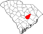
Clarendon County, South Carolina Basics:


Clarendon County South Carolina - Government Site

Population: 34,367
Area: 607 square miles
County seat: Manning
Area code(s) in use: 803 843
Time zone: EST
High school graduate or higher: 76.3%
Bachelor's degree or higher: 13.8%
Median household income: $33,267
Persons in poverty: 22.8%
Home ownership rate: 71.7%
Mean travel time to work: 26.9 minutes


Adjacent counties:
Berkeley  Calhoun  Florence  Orangeburg  Sumter  Williamsburg  

Find in South Carolina

Map of the Clarendon County area


Our detail map of Clarendon County shows the Clarendon County, South Carolina boundary lines and other interesting items.

Places in Clarendon County, South Carolina

  Airports     show all on map

Byrd Field Airport, Clarendon Memorial Hospital Heliport, Palmetto Air Plantation Airport, Pocotaligo Airport, Santee Cooper Regional Airport, Yahu Field Airport

  Bays     show all on map

Cantey Bay, Tranquility Cove

  Bridges     show all on map

Brewington Crossing, Francis Marion Bridge, Gilliard Crossing, Midway Crossing, W J Gooding Bridge

  Buildings     show all on map

City of Manning Fire Department, Clarendon County Court House, Clarendon County Emergency Services Fire Department, Clarendon County Fire Department Brewington Foreston, Clarendon County Jail, Clarendon County Rural Fire Department Alcolu, Clarendon County Rural Fire Department Barrineau, Clarendon County Rural Fire Department Davis, Clarendon County Rural Fire Department Gable - Sardinia, Clarendon County Rural Fire Department Headquarters, Clarendon County Rural Fire Department Liberty, Clarendon County Rural Fire Department Panola - Rimini, Clarendon County Rural Fire Department Paxville, Clarendon County Rural Fire Department Santee, Clarendon County Rural Fire Department Summerton, Clarendon County Rural Fire Department Taw Caw, Clarendon County Rural Fire Department Turbeville, Clarendon County Rural Fire Department Union Oakdale, Clarendon County Rural Fire Department Wyboo, Clarendon County Sheriff's Office, Clarendon County Sheriff's Office and Detention Center, Dennis Memorial Auditorium, Free Will Baptist Childrens Home, Harvin Clarendon County Library, Manning Police Department, Midlands MedTech, South Carolina Highway Patrol, Summerton Police Department, Turbeville Correctional Institution, Turbeville Police Department, Turbeville Town Hall

  Capes     show all on map

Paradise Point

  Cemeteries     show all on map

Brewington Cemetery, Brown Cemetery, Butler Cemetery, Calvary Cemetery, Ebenezer Cemetery, Evergreen Cemetery, Fellowship Cemetery, Hodges Cemetery, Home Branch Cemetery, Lees Cemetery, Manning Cemetery, New Town Cemetery, Rehoboth Cemetery, Richardson Cemetery, Saint James Cemetery, Saint Paul Cemetery, Trinity Cemetery

  Census     show all on map

Alcolu Census Designated Place

  Churches     show all on map

Alcolu Baptist Church, All Saints Episcopal Church, Andrews Chapel, Antioch Church, Barrett church (historical), Barrineau Church, Bethlehem Church, Big New Hope Church, Biggers Church, Bloomville Church, Brewington Church (historical), Briggs Chapel, Briggs Church (historical), Calvary Church, Chapel Hill Church (historical), Chapel Hill Church (historical), Church of God, Crossroads Church, Cypress Church, Cypress Fork Church, Delain Chapel (historical), Douglas Fork Church (historical), Ebenezer Baptist Church, Ebenezer Church, Elizabeth Church, Emmanuel Church, Fair Haven Church, Foreston Church, Foreston Church (historical), Friendship Church, Friendship Church, Gamble Chapel, Goodwill Church, Goodwill Church (historical), Goodwill-Santee Church, Green Hill Church, Green Hill Church, Green Savannah Church, Gumspring Church, Halleytown Church (historical), Harmony Church, Hickory Grove Church, Holiness Church, Holiness Church, Holy Rock Church (historical), Home Branch Church, Howard Chapel, James Chapel (historical), Jordan Church, Kings Chapel, Knights Hill Church, Laurel Hill Church, Liberty Church, Liberty Hill Church, Little Bethel Church, Little Star Church, Little Star Church (historical), Live Oak Church, Loadabar Church (historical), Loadagal Church, Macedonia Church, Manning Baptist Church, Manning Methodist Church, Manning Presbyterian Church, Melina Church, Midway Church, Mount Chapel Church, Mount Hermon Church (historical), Mount Hope Church, Mount Milian Church, Mount Nebo Church, Mount Pleasant Church, Mount Pleasant Church, Mount Zero Church, Mount Zion Church, New Bethany Church, New Branch Church, New Covenant Presbyterian Church, New Harmony Church, New Hope Church, New Light Church, New Town Church, New Zion Church, New Zion Church (historical), New Zion Church (historical), Oak Grove Church, Oak Grove Church, Oak Grove Church, Oak Grove Church, Oak Grove Church, Oak Grove Church (historical), Oaks Church, Old Evening Light Church (historical), Pine Grove Church, Pisgah Church, Pleasant Grove Church, Providence Church, Rambay Church, Reevesville Church, Rehoboth Church (historical), Rock Hill Church, Saint James Church, Saint James Church (historical), Saint Johns Church, Saint Lukes Church, Saint Mark Missionary Baptist Church, Saint Marks African Methodist Episcopal Church, Saint Marys Church, Saint Marys Roman Catholic Church, Saint Matthews Church, Saint Matthews Church, Saint Matthews Church, Saint Matthews Church, Saint Mattias Episcopal Church, Saint Michaels Church, Saint Paul Church, Saint Paul Church (historical), Saint Peters Church, Saint Peters Church, Saint Phillip Church, Saint Phillips Church, Sanctified Church, Sardinia Presbyterian Church, Society Hill Church, Spring Grove Church (historical), Spring Hill Church, Springhill Church, Summerton Baptist Church, Summerton Methodist Episcopal Church South, Summerton Presbyterian Church, Tawcaw Church, The Mother Church, Thomas Chapel (historical), Three Square Pond Church (historical), Trinity African Methodist Episcopal Church, Trinity Church, Union Church, Union Church, Union Hill Church, Union Hill Church, Westminister Church, Wilson Grove Church, Wilson Union Church, Wyboo Church (historical)

  Crossings     show all on map

Interchange 102, Interchange 108, Interchange 115, Interchange 119, Interchange 122, Interchange 132

  Dams     show all on map

Alderman Pond Dam D-3486, Berry Pond Dam D-3491, Buddin Pond Dam D-3485, Cuttinumber Pond Dam D-3482, Edna Ward Pond Dam D-3492, George Tindal Pond Dam D-3496, Harvin Pond Dam D-3489, Lees Number Three Pond Dam D-3506, Mcfadden Pond Dam D-3483, Plowden Pond Dam D-3493, Riggs Pond Dam D-3507, Shaw Pond Dam D-3509, South Carolina Noname 14001 D-3487 Dam, South Carolina Noname 14002 D-3498 Dam, South Carolina Noname 14003 D-3497 Dam, South Carolina Noname 14004 D-3508 Dam, South Carolina Noname 14005 D-3484 Dam, South Carolina Noname 14006 D-3481 Dam, South Carolina Noname 14007 D-3500 Dam, South Carolina Noname 14008 D-3495 Dam, South Carolina Noname 14010 D-3505 Dam, South Carolina Noname 14011 D-3504 Dam, South Carolina Noname 14012 D-3499 Dam, South Carolina Noname 14013 D-3503 Dam, South Carolina Noname 14015 D-3490 Dam, South Carolina Noname 14016 Dam, South Carolina Noname 14017 D-3494 Dam, W J Jackson Pond Dam D-3488, Wards Pasture Pond Dam D-3502

  Guts     show all on map

Still Creek

  Hospitals     show all on map

Clarendon Memorial Hospital, Turbeville Correctional Institution Infirmary

  Islands     show all on map

Blackoak Island (historical), Conyer Lake Island, Goat Island, Green Island, Persanti Island, Pine Island, Round Island, Stave Island (historical)

  Lakes     show all on map

Brewington Lake, Brown Lake (historical), Colclough Pond, Cuddo Lake (historical), Goshing Pond, Home Lake, Jordan Pond, Jordan Pond (historical), Martins Lake, Pine Grove Lake (historical), Polly Cantey Pond, Prince Pond (historical), Scotts Lake (historical), Sullivan Lake (historical)

  Locales     show all on map

Bi-Lo Plaza Shopping Center, Camp Cooper, Camp Harmony, Camp Robinson, Camp Shelor, Clarendon Golf And Country Club, Elliots Landing, Fort Watson (historical), Foxboro Golf Club, Goat Island Landing, Manning Wastewater Treatment Facility, New Zion Station, Potato Creek Landing, Sean's Poultry Farm, Wrights Landing (historical)

  Parks     show all on map

Santee National Wildlife Refuge, Taw Caw Creek Park

  Populated Places     show all on map

Adams Landing, Alcolu, Baggette Crossroads, Barrineau Crossroads, Beards Crossroads, Belser Crossroads, Bloomville, Bonanza (historical), Brewington (historical), Central Crossroads, Country Club Estates, Cypress Fork Crossroads, Davis Crossroads, Davis Station, Durant, Eagle Point, Foreston, Frierson, Gable, Halleytown, Harvin, James Crossroads, Jordan, Juneville, Log Jam Landing, Manning, New Zion, Panola, Paxville, Polly Landing, Rimini, Rodgers, Rowland, Saint Paul, Sardinia, Seloc, Shad Moss village, Silver, Summerton, Trinity Cross Roads, Turbeville, Union Crossroads, White Oak, Wilson, Wilson Crossroads, Wyboo Plantation

  Post Offices     show all on map

Alcolu Post Office, Davis Station Post Office, Gable Post Office, Manning Post Office, Paxville Post Office, Sardinia Post Office, Turbeville Post Office

  Reservoirs     show all on map

Alderman Pond, Berry Pond, Buddin Pond, Cuttinumber Pond, Cypress Lake, Dingle Pond, Edna Ward Pond, Elliot Pond, Elliott Millpond, Fox Tindal Pond, G Tindal Pond, Hardy Pond, Harvin Pond, Lakewood, Lakewood Lake, Lakewood Pond, Lees Number One Pond, Lees Number Three Pond Dam, Lees Number Two Pond, Lib Pines Lake, Mcfaddens Pond, Rainbow Lake, Riggs Pond, Sigmon Pond, Stukes Pond, Summerton Waste Treatment Pond, W J Jackson Pond

  Schools     show all on map

Alcolu Elementary School, Barrineau School (historical), Baywood School (historical), Bethel School (historical), Bethel School (historical), Bethel School (historical), Bloomville School (historical), Briggs School (historical), Burnt Branch School (historical), Butler School (historical), Central School (historical), Clarendon Hall School, Cobia School (historical), Cross Roads School (historical), Cypress Folk School (historical), Deep Creek School (historical), Douglas School (historical), Duffie School (historical), East Clarendon Elementary School, East Clarendon High School, East Clarendon Middle School, East Clarendon School, Ebenezer School (historical), Eden Street School (historical), Enterprise School, Felton Rosenwald School (historical), Foreston School (historical), Friendship School, Gable School (historical), Goodwill School (historical), Green Savanna School (historical), Halleytown School (historical), Harvin School, Hickory Grove School (historical), Hicks School, Holliday School (historical), Home Branch School (historical), Howard Chapel School (historical), Jordan School (historical), Jordan School (historical), Juneburn School (historical), Laurence Manning Academy, Liberty Hill School, Liberty Hill School (historical), Loadabar School (historical), Malina School, Manning Academy (historical), Manning High School, Manning Middle School, Manning Primary School, Manning Training School (historical), McFadden School (historical), Middle School, Mount Chapel School (historical), Mount Nero School (historical), Mount Olive School (historical), New Hope School (historical), New Panola School (historical), New Road School (historical), Oak Grove School, Oak Grove School (historical), Oak Grove School (historical), Oak Grove School (historical), Oak Grove School (historical), Oakdale School, Oaks School (historical), Panole School (historical), Paxville School (historical), Pine Dale School (historical), Pine Grove School (historical), Pleasant Grove School (historical), Rambay School (historical), Reevesville School (historical), Rockland School (historical), Rockmart School (historical), Saint James School (historical), Saint John School (historical), Saint John School (historical), Saint Mark School (historical), Saint Marks School (historical), Saint Marys School (historical), Saint Matthews School (historical), Saint Michael School (historical), Saint Peters School (historical), Saint Phillips School (historical), Salem School (historical), Sandbed School (historical), Santee Rosenwald School (historical), Santee School (historical), Scott Branch School, Silver School (historical), Slader Nelson School (historical), Society Hill School (historical), Spring Grove School (historical), Spring Hill School (historical), Springhill School, Summerton Graded School (historical), Summerton High School (historical), Trinity School (historical), Union Hill School, Wells School (historical), Westminister School (historical), Wilson Mill School (historical), Wilson School (historical), Wilson School (historical), Wilson Union School (historical), Zoar Hill School (historical)

  Streams     show all on map

Ballard Creek, Bear Creek, Bell Branch, Belser Creek, Bennets Branch, Bennetts Branch, Big Branch, Big Branch, Big Branch, Big Branch, Birch Branch, Bluff Branch, Breakfast Branch, Broad Branch, Broadway Branch, Brunson Branch, Buckhead Branch, Burnt Branch, Cain Branch, Carroll Slough, Chapel Branch, Chapel Creek, Church Branch, Clubhouse Branch, Davis Branch, Davis Branch, Dean Swamp, Deep Creek, Des Champs Branch, Doctor Branch, Douglas Swamp, Fellowship Branch, Grimes Creek, Guckolds Branch, Half Way Creek, Hicks Branch, Highland Creek, Hog Branch, Home Branch, Horse Branch, Hungary Hall Branch, Jacks Creek, Joes Branch, Juneburn Branch, Key Branch, Knife Branch, Lakewood Creek, Lemon Branch, Lightwood Knot Branch, Little River, Little Tawcaw Creek, Lizzies Branch, Loss Branch, McCoys Branch, Meetinghouse Branch, Mill Branch, Mill Branch, Mill Branch, Mount Hope Swamp, Newman Branch, Ox Swamp, Peddlers Branch, Pen Branch, Pocotaligo River, Potato Creek, Richardson Branch, Rooty Branch, Rosehen Branch, Sammy Swamp, Savanna Branch, Scott Branch, Spreadoak Branch, Spring Branch, Spring Branch, Spring Grove Creek, Sullivans Branch, Tancaw Creek, Tarkiln Branch, Tawcaw Creek, Taylor Branch, Tearcoat Branch, Three Hole Swamp, Torkiln Branch, Trustless Branch, White Oak Branch, White Oak Creek, Wildcat Branch, Wyboo Swamp

  Swamps     show all on map

Bee Tree Bay, Big Bay, Black River Swamp, Boggy Bay, Buck Bay, Bullhead Bay, Conyers Bay, Crow Bay, Cutno Bay, Cypress Bay, Dial Bay, Doctor Bay, Dogwood Pond, Elwood Bay, Fuller Bay, Guise Bay, Gum Pond, Hog Bay, Hog Meadow Swamp, Indian Bay, Islanded Bay, Junkyard Bay, Lake Marion, Little Junkyard Bay, Monkey Bay, Pigeon Bay, Rosehen Bay, Sandhill Bay, Tiger Bay, White Pond

  Towers     show all on map

Foreston Lookout Tower, New Zion Lookout Tower, Summerton Lookout Tower, WYMB-AM (Manning), WYMB-AM (Manning),

Clarendon County, South Carolina Population By Race (2012 estimate)

RacePopulation
BlackClarendon County Black population 16,97716,977  
WhiteClarendon County White population 16,77116,771
MixedClarendon County Mixed population 309309
AsianClarendon County Asian population 241240
American IndianClarendon County American Indian population 103103
Hawaiian & Pacific IslanderClarendon County Hawaiian & Pacific Islander population 00

Additional population tables :
State population table
South Carolina population by county