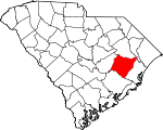
Williamsburg County, South Carolina Basics:


Williamsburg County South Carolina - Government Site

Population: 33,581
Area: 934 square miles
County seat: Kingstree
Area code(s) in use: 843
Time zone: EST
High school graduate or higher: 77.1%
Bachelor's degree or higher: 12.3%
Median household income: $25,174
Persons in poverty: 29.9%
Home ownership rate: 73.6%
Mean travel time to work: 27.7 minutes


Adjacent counties:
Berkeley  Clarendon  Florence  Georgetown  Marion  

Find in South Carolina

Map of the Williamsburg County area


Our detail map of Williamsburg County shows the Williamsburg County, South Carolina boundary lines and other interesting items.

Places in Williamsburg County, South Carolina

  Airports     show all on map

Hemingway-Stuckey Airport, Lane Airport (historical), McIntosh Airport, Williamsburg Regional Airport

  Basins     show all on map

Big Bay, Burgess Bay, Burton Bay, Dobson Bay, Lin Whites Bay, Lower Rutledge Bay, McCants Bay, Pine Island Bay, Round Bay, Rutledge Bay, Whiteoak Bay, Whites Bay, Wildcat Bay, Wolf Bay

  Bridges     show all on map

Murrays Ferry Bridge, Wallace D Conner Bridge

  Buildings     show all on map

Adams Life Link Ambulance, Federal Correctional Institution Williamsburg, First Care Medical Transport, Greeleyville Police Department, Hemingway Fire Department, Hemingway Police Department, Kershaw Memorial Library, Kingstree City Hall, Kingstree Fire Department, Kingstree Police Department, Kingstree Town Hall, Lake City Police Department, Lane Town Hall, South Carolina Highway Patrol, South Lynches Fire Department Station 4, Williamsburg County Courthouse, Williamsburg County Disaster Preparedness Agency, Williamsburg County Fire Department Bloomingville, Williamsburg County Fire Department Cedar Creek, Williamsburg County Fire Department Central, Williamsburg County Fire Department Cooper Brothers, Williamsburg County Fire Department Earles, Williamsburg County Fire Department Greeleyville, Williamsburg County Fire Department Headquarters, Williamsburg County Fire Department Lane, Williamsburg County Fire Department Morrisville, Williamsburg County Fire Department Mount Vernon, Williamsburg County Fire Department Mouzon, Williamsburg County Fire Department Muddy Creek, Williamsburg County Fire Department Nesmith, Williamsburg County Fire Department Salters, Williamsburg County Fire Department Stuckey, Williamsburg County Fire Department Suttons, Williamsburg County Fire Department Trio, Williamsburg County Jail, Williamsburg County Library, Williamsburg County Sheriff's Department, Williamsburg County Sheriff's Office, Williamsburg Technical College Library

  Canals     show all on map

Kingstree Swamp Canal

  Cemeteries     show all on map

Bird Pond Cemetery, Black Mingo Cemetery, Bloomingvale Cemetery, Cades Cemetery, Cedar Swamp Cemetery, Cedar Swamp Cemetery, Cooper Cemetery, Ebenezer Cemetery, Elim Cemetery, Graham Cemetery, Harmon Cemetery, Harmony Cemetery, Indiantown Cemetery, Johnson Cemetery, Keels Cemetery, McClary Cemetery, McClary Cemetery, Midway Cemetery, Mount Hope Cemetery, Mount Lebanon Cemetery, Mount Vernon Cemetery, Nesmith Cemetery, Poplar Hill Cemetery, Richmond Cemetery, Salters Cemetery, Spring Gully Cemetery, Sutton Cemetery, Union Cemetery, Williamsburg Presbyterian Cemetery

  Churches     show all on map

Allen Chapel, Allen Church, Antioch Church, Antioch Church, Asbury Church, Beach Swamp Church, Bethel Church, Bethel Church, Bethel Church, Bethesda Church, Bethesda Church, Bethlehem Church, Bethlehem Church, Beulah Church, Beulah Church, Beulah Church, Birch Creek Church, Black Mingo Church, Black River Church, Black River Church, Blake Church, Bloomingvale Baptist Church, Cades Pentecoastal Holiness Church, Cane Branch Church, Cedar Creek Church, Cedar Grove Church, Cedar Grove Church, Cedar Swamp Baptist Church, Cedar Swamp Methodist Church, Central Church, Central Church, Charity Church, Chavis Church, Church of God, Church of God and True Holiness, Concord Church, Dickey Chapel, Earls Methodist Episcopal Church South, Ebenezer Methodist Church, Elijah Church, Elim United Methodist Church, Evangelistic Temple Wat Church, First Baptist Church, First Old Mount Zion African Methodist Episcopal Church, Floyd Tabernacle, Friendship Church, Goodwill Church, Great Pleasant African Methodist Episcopal Church, Greater Bethel African Methodist Episcopal Church, Greeleyville Church, Harmony Church, Hebron Methodist Church, Henry Church, Hickory Grove Church, Hickory Grove Church, Hickory Hill Church, Holiness Church (historical), Holiness Church (historical), Honey Hill Church, Howard Church, Huggins Church, Indiantown Presbyterian Church, Jehovah Church, Jeremiah Church, Jerusalem African Methodist Episcopal Church, Jerusalem Church, Kennedyville Church, Kingstree Baptist Church, Kingstree Presbyterian Church, Kingstree United Methodist Church, Lane Chapel, Laws Swamp Church, Little Star Church, Long Branch Church, Long Branch Church, Macedonia Church, Macedonia Church, Manbess Church, Mathews Hill Church, Matthews Church, Midway Baptist Church, Midway Church, Millwood Methodist Episcopal Church South, Morning Star Church, Mortons Church, Mount Arat Church, Mount Carmel Church, Mount Cedar Church, Mount Hope Church, Mount Moriah Church, Mount Olive Church, Mount Vernon Church, Mount Zion Church, Mount Zion Church, Mount Zion Church, Mount Zion Church, Mount Zion United Methodist Church, Mouzon Church, Nazareth African Methodist Episcopal Church, Nesmith Missionary Baptist Church, New Bethel Church, Oak Grove Church, Oak Grove Church (historical), Oak Ridge Church, Pergamus Church, Pilgrim Church, Pine Grove Church, Pine Grove Church, Piney Forest Church, Poplar Hill Church, Randy Grove Church, Rehoba Church, Richmond Church, Rock Hill Church, Saint Agey Church, Saint Albans Episcopal Church, Saint Anns Catholic Church, Saint James Church, Saint James Church, Saint James Church, Saint John Church, Saint John Church, Saint Johns Church, Saint Johns Church, Saint Johns Church, Saint Johns Church, Saint Johns Holiness Church, Saint Luke Church, Saint Lukes Church, Saint Lukes Church, Saint Lukes Church, Saint Mark Church, Saint Marks Church, Saint Marks Church, Saint Marys Church, Saint Marys Church, Saint Marys Church, Saint Marys Holiness Church, Saint Matthews Church, Saint Michael Church, Saint Paul Church, Saint Paul Church, Saint Pauls Church, Saint Peter Church, Saint Phillips Church, Saint Rest Church, Saint Stephen Church, Salters Methodist Church, Sand Hill Church, Sandridge Church, Sandy Bay Church, Sandy Grove Church, Second Baptist Church, Siloam Baptist Church, Singleton Church, Snow Hill Church, Spring Gully Church, Spring Hill Church (historical), Spring Pond Church, Sutton Church, Thompson Church, Trinity Baptist Church, Trio Methodist Episcopal Church South, Union Church, Union Church, Weldon Church, Wesley Church, Williamsburg Presbyterian Church, Wilsons Chapel, Workman Methodist Episcopal Church South (historical)

  Crossings     show all on map

Hicksons Ferry (historical), Lower Crossing, Murrays Ferry (historical)

  Dams     show all on map

A H Parsons Pond Dam D-3088, Ackerman Pond Dam D-3096, Billy Cox Lower Pond Dam D-3089, Billy Cox Upper Pond Dam D-3090, Brockington Pond Dam D-3100, George Lewis Pond Dam D-3102, J P Gamble Pond Dam, Kingstree Oxidation Pond Dam D-3086, Lakewood Pond Dam D-3097, McCollough Upper Pond Dam D-3091, Scott Pond Dam D-3087, Snowden Pond Dam D-3098, South Carolina Noname 45001 D-3101 Dam, South Carolina Noname 45002 D-3099 Dam, South Carolina Noname 45003 D-3095 Dam, South Carolina Noname 45004 D-3094 Dam, South Carolina Noname 45005 D-3081 Dam, South Carolina Noname 45006 D-3092 Dam, South Carolina Noname 45009 D-3082 Dam, South Carolina Noname 45015 D-3093 Dam, W S McCollough Junior Pond Dam D-3085, Webber Pond Dam D-3083

  Flats     show all on map

Dog Creek Flats

  Hospitals     show all on map

Johnson Hospital, Kelley Memorial Hospital (historical), Williamsburg Regional Hospital, Williamsburg Regional Hospital

  Islands     show all on map

Rough Island, Wittee Island

  Lakes     show all on map

Broad Lake, Conyer Lake, Doctor Hole, Duke Lake, Ferry Lake, Franks Lake, Horse Pond, Little Lake, Staple Lake, Williams Pond, Wilson Lake, Wittee Lake, Wittee Lake

  Locales     show all on map

Boswells Beach, Burrows Hall, Cooper Crossroads, Faircloth Plantation, Hemingway Commerce Center, Holly Tree Plantation, Kings Tree Plaza Shopping Center, Kingstree Golf Course, Kingstree Square Shopping Center, Kingstree Wastewater Treatment Plant, Long Lands Plantation, Rhems Plantation, Scott Woods Plantation, South Carolina Gun Club, Spring Bank Plantation, Swamp Fox Golf Club

  Parks     show all on map

Kingstree Historic District

  Populated Places     show all on map

Andrews, Antioch, Ard Crossroads, Baker Crossroads, Bartell Crossroads, Belsers Crossroads, Blakely, Bloomingvale, Brockington, Brunson Crossroads, Bryans Crossroads, Cades, Carris, Cedar Creek, Cedar Swamp, Chandlers, Cherry Hill, Clarks Crossroads, Cook, Cook Corner, Cooper, Dorseytown, Earle, Edwards, Fowler, Gordonville, Gourdin, Greeleyville, Harper Crossroads, Hebron Crossroads, Heineman, Hemingway, Henry, Hogeye Crossroads, Hopewell, Indiantown, Kellehan Crossroads, Kingstree, Lane, Martin Corner, Martins Crossroads, Midway Crossroads, Millwood, Moore Crossroads, Morrisville, Mouzon, Muddy Creek Crossroads, Nesmith, New Market (historical), Nexsen (historical), Oak Ridge, Old Morrisville, Outland, Poplar Hill, Rock Bluff, Rome, Saint Johns Crossroads, Salters, Salters Depot, Singletary Forks, Snow Junction, Snow Town, Stuckey, Suttons, Taft, Terrell Crossroad, Tisdale, Trio, Union Crossroads, Warsaw, Willtown (historical), Woodland Acres, Workman

  Post Offices     show all on map

Cooper Post Office (historical), Greeleyville Post Office, Hemingway Post Office, Kingstree Post Office, Lane Post Office, Nesmith Post Office

  Reservoirs     show all on map

Ackerman Pond, Billy Cox Upper Pond, Brockington Pond, Browns Pond, Ervins Pond, George Lewis Pond, J P Gamble Pond, Jack McGill Pond, Kingstree Oxidation Pond, Lakewood Pond, Longlands Hope Swamp Pond, Longlands House Pond, Parsons Pond, Rames Farm Pond, Scott Pond, Sheppard Pond, Snowden Pond, W S McCollough Junior Pond, Webber Pond

  Ridges     show all on map

Big Ridge

  Schools     show all on map

Aimwell School (historical), Allen Chapel School (historical), Battery Park Elementary School, Bennett School (historical), Bethel School, Bethel School, Bethesda School (historical), Bethlehem School, Beulah School, Beulah School (historical), Beulah School (historical), Birch Creek School, Blakely School, Bloomingvale School, Broad Swamp School (historical), Brown School, Burrows School, C E Murray High School, Cades - Hebron Elementary School, Cades School (historical), Cane Branch School (historical), Carris School (historical), Cedar Swamp School (historical), Central School, Central School, Chavis Elementary School, Chavis School (historical), Coldwater School, Cooper School, D P Cooper Elementary School, Dorsey Town School, Earle School (historical), Earle School (historical), Fowler School, Goins School, Great Pleasant School (historical), Greeleyville Elementary School, Green School, Hebron School, Hebron School (historical), Heineman School (historical), Hemingway Career and Technology Center, Hemingway High School, Hickory Hill School (historical), Hunter School (historical), Hunter School (historical), Indian Town School, Indiantown Academy (historical), Indiantown School (historical), Inglenook School (historical), Jerusalem School, Johnson Swamp School (historical), King School, Kingstree Elementary School, Kingstree Junior High School, Kingstree Senior High School, Leneuds School (historical), Little Branch School, Longwood School (historical), Macedonia School, Marion School, Mary School (historical), Midway School, Millwood School, Mount Arat School (historical), Mount Vernon School (historical), Mount Zion School, Mount Zion School, Mouzon School, Muddy Creek School, Nesmith School, Never Fail School (historical), Oak Grove School, Oak Ridge School (historical), Pine Grove School (historical), Pine Grove School (historical), Piney Forest School, Retreat School (historical), Roper School (historical), Rough Branch School (historical), Saint James School, Saint James School (historical), Saint John School, Saint John School, Saint John School (historical), Saint Johns School (historical), Saint Lawrence School, Saint Lukes School, Saint Mark Elementary School, Saint Marks School, Saint Marks School (historical), Saint Marys School (historical), Saint Matthews School, Saint Matthews School (historical), Saint Michael School, Saint Pauls School (historical), Sandy Bay School, Sandy Bay School, Sandy Grove School (historical), Shavers School, Shaw School, Singleton School (historical), Snow Hill School, Spring Branch School (historical), Sutton School (historical), Terry School, The King's Academy, The Living Word Christian School, Thomas School (historical), Thompson School (historical), Tomlinson High School, Union School, Union School, W M Anderson Primary School, Ward School (historical), Warsaw School, Warsaw School (historical), Wayside School, Wee Nee School, Wee Tee School (historical), Whiteoak School (historical), Williamsburg Academy (historical), Williamsburg County Headstart School, Williamsburg Technical College, Williamsburg-Blakely Elementary/Middle School, Wittee School

  Streams     show all on map

Bennett Swamp, Birch Creek, Black Mingo Creek, Boggy Swamp, Boggy Swamp, Brunson Branch, Bull Branch, Burnett Swamp, Camden Swamp, Campbell Branch, Campbell Swamp, Caney Branch, Cedar Branch, Cedar Swamp, Chaney Swamp, Chapel Branch, Clapp Swamp, Dickey Swamp, Dobson Branch, Dry Swamp, Flat Swamp, Gin Branch, Grahams Mill Branch, Gully Branch, Gumtree Branch, Gumtree Branch, Headless Creek, Hickory Nut Branch, Holliman Swamp, Home Swamp, Hughs Branch, Indiantown Swamp, Island Branch, Jacks Creek, James Branch, Johnson Branch, Johnsons Swamp, Jumping Run, June Branch, Laws Swamp, Log Branch, Long Branch, Long Branch, Long Branch, McElroy Branch, McKnight Swamp, McNamee Swamp, Mill Branch, Mill Branch, Mill Branch, Mill Creek, Mill Creek, Mulberry Branch, Murray Swamp, Ox Swamp, Paisley Swamp, Parsley Swamp, Penn Branch, Poplar Hill Branch, Pudding Swamp, Pushing Branch, Rocky Ford Swamp, Rome Branch, Roper Branch, Shaler Branch, Shanty Branch, Singleton Swamp, Sleeper Branch, Smith Swamp, Smith Swamp, Smiths Bay, Snow Branch, Sportsman Pond, Spring Branch, Spring Branch, Stony Run Branch, Stump Branch, Thorntree Swamp, Turkey Creek, Walden Branch, Walnut Branch, Waterman Branch, Whiteoak Swamp, Whiteoak Swamp, Wittee Branch

  Swamps     show all on map

Alligator Bay, Baker Swamp, Butlers Bay, Camp Pond Bay, Cedar Bay, Cedar Creek Bay, Chicken Swamp, Cow Head Bay, Cypress Pond, Doctor Hole, Findley Bay, Flat Swamp, Graham Swamp, Johnsons Swamp, Juniper Run, Long Bay, Oak Ridge Bay, Orr Swamp, Ricefield Bay, Sandy Bay, Sportsman Pond, Spring Bay, Spring Valley Swamp, The Morass, Tupelo Bay, Wittee Bay

  Towers     show all on map

Cook Fire Tower, Cooper Fire Tower, Earle Lookout Tower, Lane Fire Tower, WDKD-AM (Kingstree), WHLZ-FM (Manning), WKSP-AM (Kingstree), WKYB-AM (Hemingway), WTUA-FM (Saint Stephen), WWKT-FM (Kingstree)

  Valleys     show all on map

Spring Gully,

Williamsburg County, South Carolina Population By Race (2012 estimate)

RacePopulation
BlackWilliamsburg County Black population 22,02922,029  
WhiteWilliamsburg County White population 11,04811,048
MixedWilliamsburg County Mixed population 269268
American IndianWilliamsburg County American Indian population 134134
Hawaiian & Pacific IslanderWilliamsburg County Hawaiian & Pacific Islander population 00

Additional population tables :
State population table
South Carolina population by county