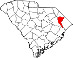
Marion County, South Carolina Basics:


Marion County South Carolina - Government Site

Population: 32,414
Area: 489 square miles
County seat: Marion
Area code(s) in use: 843
Time zone: EST
High school graduate or higher: 80.7%
Bachelor's degree or higher: 12.1%
Median household income: $30,562
Persons in poverty: 25.2%
Home ownership rate: 67.4%
Mean travel time to work: 26.5 minutes


Adjacent counties:
Dillon  Florence  Georgetown  Horry  Williamsburg  

Find in South Carolina

Map of the Marion County area


Our detail map of Marion County shows the Marion County, South Carolina boundary lines and other interesting items.

Places in Marion County, South Carolina

  Airports     show all on map

Marion County Airport

  Basins     show all on map

Ellerbe Bay, Gum Swamp Bay, Terrell Bay

  Bays     show all on map

Grassy Bay

  Bends     show all on map

Horseshoe Bend, Worly Cut

  Bridges     show all on map

Godfrey Ferry Bridge, Potatoe Bed Ferry Bridge

  Buildings     show all on map

Britton's Neck - Gresham Fire Department, Brittons Neck Gresham Fire Department, Centenary Volunteer Fire Department, Marion City Hall, Marion County Courthouse, Marion County Emergency Management Office, Marion County Emergency Medical Services, Marion County Jail, Marion County Law Enforcement Center, Marion County Library, Marion County Sheriff's Office, Marion County Sheriff's Office, Marion Fire Department, Marion Fire Department Station 2, Marion Police Department, Marion Police Department Community Substation, Marion Police Department Substation, Marion Rescue Squad, Marion Rural Fire Department, Mullins Branch Marion County Library, Mullins City Hall, Mullins Community Fire Department Mullins, Mullins Municipal Court, Mullins Nursing Center, Mullins Police Department, Mullins Police Department, Nichols Library, Nichols Police Department, Nichols Volunteer Fire Department, Pee Dee Rural Fire Department, Rains Volunteer Fire Department, South Carolina Law Enforcement Division, South Carolina Tobacco Museum, Temperance Hill Fire Department

  Canals     show all on map

Catfish Canal

  Capes     show all on map

Britton Neck, Clark Point, The Corner, Wahee Neck

  Cemeteries     show all on map

Allen Cemetery, Ammons Cemetery, Baker Cemetery, Baxley Cemetery, Bay Cemetery, Brown Cemetery, Bryant Cemetery, Christmas Cemetery, Clay Hill Cemetery, Durant Cemetery, Ebenezer Cemetery, Ford Cemetery, Jones Cemetery, Kirton Cemetery, Lambert Cemetery, Lane Cemetery, Lee Cemetery, Livingston Cemetery, Moody Cemetery, Nazarene Cemetery, New Cemetery, New Life Cemetery, Nichols Cemetery, Nichols-Jones Cemetery, Old Field Cemetery, Olivet Cemetery, Palmer Cemetery, Powers Cemetery, Rose Hill Cemetery, Smith Cemetery, Smithy Cemetery, Spencer Cemetery, Springville Cemetery, Tabernacle Cemetery, Turner Cemetery, Wahee Cemetery, Wahee Cemetery, Waldon Cemetery

  Churches     show all on map

Antioch Baptist Church, Ariel Church, Bethel African Methodist Episcopal Church, Bethel Church (historical), Bethel United Methodist Church, Bethlehem African Methodist Episcopal Church, Bethlehem Baptist Church, Bethlehem Church, Bethlehem Church, Beulah Methodist Episcopal Church (historical), Blessed Hope Baptist Church, Buzzard Skull Church, Catholic Church of the Infant Jesus, Centenary Church, Center Church, Centerville Baptist Church, Central Church, Christ Episcopal Church, Christian Faith Baptist Church, Church of Christ, Church of God, Church of the Advent, Daviston Church of God, Door of Hope Christian Church, East Marion Pentecostal Holiness Church, Ebenezer African Methodist Episcopal Church, Ebenezer Church, Effingham Church, Ellen Chapel Holiness Church, Everbee Church, Faith Apostolic Church of Jesus Christ, First Faith Assembly Church, First Friendship Baptist Church, First United Methodist Church, Forks Chapel, Friendship African Methodist Episcopal Church, Friendship Church, Friendship Church, Friendship Church, Gapway Baptist Church, Greater Singletry African Methodist Episcopal Church, Gurley Church, Hickory Hill Freewill Baptist Church, Highway Church of Christ, Holy Temple Church of God In Christ, House of God In Mullins, House of God Zion Church, Jesus Christ Church, Jesus Only Church, Kingdom Hall of Jehovahs Witnesses, Little Bethel Baptist Church, Little Zion Methodist Church, Macedonia United Methodist Church, Marion Baptist Church, Marion Church of God, Marion Presbyterian Church, McMillan Memorial Baptist Church, Mill Creek Church, Miller Church, Monument of Faith Evangelistic Church, Mount Carmel Baptist Church, Mount Olive Baptist Church, Mount Olive Seventh Day Adventist Church, Mount Pisgah Baptist Church, Mount Zion African Methodist Episcopal Church, Mount Zion Church, Mullins - Marion Original Free Will Baptist Church, Mullins Church of God, Mullins First Baptist Church, Mullins First Pentecostal Holiness Church, Mullins Freewill Baptist Pentecostal Faith, Mullins Presbyterian Church, Nazarene Church, Nebo Church, New Born Assembly Church, New Faith Apostolic Church, New Life Church (historical), New Mount Zion African Methodist Episcopal Church, Nichols United Methodist Church, North Mullins Baptist Church, Oak Grove Church (historical), Old Ark Church, Old Ebenezer Church, Old Field Church, Open Door Independent Baptist Church, Pee Dee Baptist Church, Pee Dee Church, Peedee Association Church, Piney Grove Baptist Church, Pleasant Grove Church, Pleasant Grove Church (historical), Pleasant Grove Missionary Baptist Church, Pleasant Hill Church, Progressive Church of Our Lord Jesus Christ, Rain Freewill Baptist Church, Red Hill Church, Reedy Creek Church, Refuge Pentecostal Church, Saint James African Methodist Episcopal Church, Saint Johns African Methodist Episcopal Church, Saint Marks Church (historical), Saint Marys Church, Saint Matthews Church (historical), Saint Paul Baptist Church, Saint Paul Church, Saint Phillips Church, Saint Stephens Baptist Church, Saint Timothy Church, Sandy Grove Church, Sellers Chapel Baptist Church, Shiloh Church, Souls Chapel, Spring Branch Church, Springville Church, Tabernacle Church, Tabernacle Church, The Church of Jesus Christ of Latter Day Saints, The First Pentecostal Holiness Church, The Greater Highway Church of Christ, The New Greater Deliverance Church for all People, Tranquil Church, Union Church, Wahee Church (historical), Walkers Chapel, Weeping Willow Church, West Marion Baptist Church, White Church, White Hill Church, Williams Chapel African Methodist Episcopal Church, Wise Chapel, Woodlawn Park Baptist Church, Word of Faith Christian Center, Zion Church (historical), Zion Southern Methodist Church

  Cliffs     show all on map

Dunham Bluff, Lower Dog Bluff, Red Bluff, Upper Dog Bluff

  Dams     show all on map

Baxley Farm Pond Dam D-0509, Baxleys 501 Pond Dam D-0513, Gaddys Millpond D-0512 Dam, Leggett Millpond Dam D-0511, McMillen Lower Pond Dam D-0515, McMillen Upper Pond Dam D-0514, Rowell Pond Dam D-3239

  Falls     show all on map

The Falls

  Guts     show all on map

Millrace Stream

  Hospitals     show all on map

Finger Infirmary (historical), Marion County Medical Center, Marion Memorial Hospital, Martins Hospital (historical)

  Islands     show all on map

Bear Knot Island, Big Island, Blackwell Island, Byrd Island, Dickerson Island, Hickory Island, Knife Island, Little Cane Island, Millrace Islands, Mose Islands, Pee Dee Island, Pee Dee Islands, Rogers Islands, Singletary Islands

  Lakes     show all on map

Alligator Lake, Anderson Lake, Baker Lake, Balloon Lake, Bass Lake, Bee Tree Lake, Big Ben Port Lake, Big Brown Lake, Big Lake, Blocker Lake, Boat Lake, Boggy Lake, Bowen Lake, Brushy Lake, Burrell Little Lake, Byrd Lake, Cain Lake, Cannon Lake, Carey Lake, Carmichael Lake, Collin Lake, Cox Lake, Crooked Lake, Cross Lake, Cypress Creek Lake, Cypress Lake, Cypress Lake, Deep Lake, Dill Lake, Dog Lake, Elvis Lake, Fair Lake, Fishtrap Lake, Gator Lake, Gator Pond, Grassy Lake, Graves Lake, Haroldson Lake, Hemphill Lake, Hodge Lake, Home Lake, Honey Lake, Horseshoe Lake, Huggins Lake, Jack Lake, Jack Lake, Jordan Lake, Judy Lake, Little Ben Port Lake, Little Brown Lake, Lone Pine Lake, Long Lake, Lower Ford Lake, Old Dead River, Old River, Palmer Lake, Richard Lake, River Field Lake, Round Hole Lake, Russ Lake, Rye Ridge Pond, Sampson Lakes, Sara Lake, Shackleford Lake, Shaley Lake, Smokey Lake, Smoky Lake, Snowbird Lake, Spring Lake, Stone Lake, Tar Lake, Ten Acre Pond, Thomas Lake, Trout Lake, Upper Ford Lake, Widow Lake

  Locales     show all on map

Atkinson Farm, Baxley Farms, Camp Number Five, Dusty Hill Golf Club, Grice Ferry, Knife Island Landing, Lower Dog Bluff Landing, Marion Mall Shopping Center, Marion Towne Center, Mullins Wastewater Treatment Plant, Pauls Plantation (historical), Pee Dee Plaza Shopping Center, Pineland Country Club, South Main Street Wastewater Treatment Facility, Upper Dog Bluff Landing, Wateree Deer Club, White Oak Landing, Woodbury Rod and Gun Club

  Parks     show all on map

Harmon Park, Marion Historic District

  Populated Places     show all on map

Ariel Cross Road, Blue Brick, Brittons Neck, Cartwheel Landing, Catfish Landing, Centenary, Country Club Estates, Davis Landing, Daviston, Eulonia, Friendship, Gapway, Gresham, Koonce, Laughlin, Marion, Mullins, Nichols, North Mullins, Pee Dee, Pendeboro, Rains, Sampson Landing, Sellers, Smithboro, Spring Branch, Stave Landing, Tabernacle, Temperance Hill, Turner Place, West Marion, Woodbury, Zion

  Post Offices     show all on map

Centenary Post Office, Gresham Post Office, Marion Post Office, Mullins Post Office, Nichols Post Office, Rains Post Office

  Reservoirs     show all on map

Gaddy Mill Pond, Leggett Mill Pond, Smith Mill Pond

  Schools     show all on map

Beauty Spot School, Bethel School, Bethlehem School (historical), Britton Neck High School, Brittons Neck Elementary School, Cedar Grove School (historical), Centenary School (historical), Creek Bridge High School, Easterling Primary School, Friendship School, Gapway School, Gresham School, Johnakin Middle School, Marion County Technical Education Center, Marion County Training School (historical), Marion Elementary School, Marion High School, Marion Intermediate School, McCormick Elementary School, Meadow Hill School (historical), Melvin School, Mullins Early Childhood Center, Mullins Grade School (historical), Mullins High School, Nazarene School, Nebo School (historical), Nichols Elementary School, North Mullins Primary School, Old Field School (historical), Palmetto Elementary School (historical), Palmetto High School, Palmetto Middle School, Pee Dee School (historical), Penderborough School, Pleasant Hill School (historical), Rains Centenary Early Childhood Center, Saint James School, Saint Paul School, Scotch School, Singletary School, Smith Swamp School, Southside Elementary School, Spring Branch School, Springville School, Tabernacle School, Terrells Bay High School (historical), Todd School, Weeping Willow School, Zion School (historical), Zion School (historical)

  Streams     show all on map

Alligator Run, Boggy Branch, Briar Creek, Brown Swamp, Bull Swamp, Catfish Creek, Collins Creek, Crutchlow Branch, Cud Swamp, Cypress Creek, Dead River, Dead River, Fowler Branch, Jacobs Creek, Jiles Creek, Jones Swamp, Jordan Creek, Little Pee Dee River, Little Reedy Creek, Lone Pine Lake Run, Lumber River, Lynches River, Marsh Creek, Millrace Drain, Mink Creek, Palmetto Swamp, Reedy Creek, Russ Creek, Stackhouse Creek, The Gulley, The Gully, Tobys Creek, White Oak Creek

  Summits     show all on map

Heaven Hill

  Swamps     show all on map

Agnay Swamp, Back Swamp, Bear Swamp, Beverly Swamp, Big Horsepen Bay, Big Sister Bay, Boggy Bay, Buck Cove, Cane Bay, Cane Swamp, Catfish Bay, Catfish Swamp, Collins Swamp, Flat Swamp, Flax Patch Swamp, Ford Swamp, Fox Bay, Fox Bay, Giles Bay, Johnson Swamp, Keedley Swamp, Little Horsepen Bay, Little Sister Bay, Maidendown Bay, Maple Swamp, Middle Bay, Mill Bay, Piney Bay, Pitch Pot Swamp, Rabbit Bay, Raft Swamp, Reedy Creek Bay, River Swamp, Sedge Marsh, Small Marsh, Smith Swamp, Smith Swamp, Tenmile Bay, Wiggins Swamp, Wolf Pit Bay

  Towers     show all on map

Brittons Neck Lookout Tower, Marion Gresham Lookout Tower, Nichols Lookout Tower, WCIG-FM (Mullins), WJAY-AM (Mullins), WKSY-FM (Marion), WKXS-AM (Marion), WWPD-FM (Marion),

Marion County, South Carolina Population By Race (2012 estimate)

RacePopulation
BlackMarion County Black population 18,18418,184  
WhiteMarion County White population 13,45213,451
MixedMarion County Mixed population 357356
American IndianMarion County American Indian population 194194
Hawaiian & Pacific IslanderMarion County Hawaiian & Pacific Islander population 00

Additional population tables :
State population table
South Carolina population by county