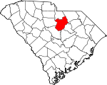
Kershaw County, South Carolina Basics:


Kershaw County South Carolina - Government Site

Population: 62,200
Area: 727 square miles
County seat: Camden
Area code(s) in use: 803 843
Time zone: EST
High school graduate or higher: 83.9%
Bachelor's degree or higher: 18.6%
Median household income: $44,068
Persons in poverty: 16.1%
Home ownership rate: 78.0%
Mean travel time to work: 27.8 minutes


Adjacent counties:
Chesterfield  Darlington  Fairfield  Lancaster  Lee  Richland  Sumter  

Find in South Carolina

Map of the Kershaw County area


Our detail map of Kershaw County shows the Kershaw County, South Carolina boundary lines and other interesting items.

Places in Kershaw County, South Carolina

  Airports     show all on map

El Porvenir Airpark, Kershaw Airport (historical), Over the Hill Airport, Woodward Field Airport

  Bends     show all on map

Devils Elbow

  Bridges     show all on map

Blakneys Bridge (historical), Fran Bridge (historical), Houghs Bridge, McGougans Bridge, Porter Bridge, Tillers Bridge, Youngs Bridge, Youngs Bridge (historical)

  Buildings     show all on map

Bethune City Hall, Bethune Police Department, Bethune Public Library, Bethune Volunteer Rescue Squad, Camden Archives and Museum Library, Camden City Hall, Camden Conference Center, Camden Fine Arts Center, Camden Fire Department, Camden Fire Department, Gates Hill Community House (historical), Kershaw County Courthouse, Kershaw County Fire Department Boykin, Kershaw County Fire Department Flat Rock, Kershaw County Fire Department Gates Ford, Kershaw County Fire Department North Central, Kershaw County Fire Department Pine Grove, Kershaw County Fire Department Pine Grove Substation, Kershaw County Fire Department Shepard, Kershaw County Fire Department Westville, Kershaw County Fire Service Cassatt, Kershaw County Fire Station Antioch, Kershaw County Fire Station Baron DeKalb, Kershaw County Fire Station Beaver Creek, Kershaw County Fire Station Bethune, Kershaw County Fire Station Blaney, Kershaw County Fire Station Buffalo Mount Pisgah, Kershaw County Fire Station Charlotte Thompson, Kershaw County Fire Station Doby's Mill, Kershaw County Jail, Kershaw County Library, KershawHealth Emergency Medical Services, Lugoff Fire Department Station 10, Lugoff Fire Department Station 8, Lugoff Fire Department Station 9, Mount Pisgah Buffalo Rescue Squad, Rhame Arena, South Carolina Highway Patrol Troop 1 Post B, Wateree Power Plant

  Canals     show all on map

Gilles Ditch, Jumping Gully, Wateree Canal (historical)

  Capes     show all on map

Belmont Neck, Betty Neck, Friends Neck, Gibsons Neck

  Cemeteries     show all on map

Beaver Creek Cemetery, Beaver Creek Cemetery, Bethel Cemetery, Boykin Cemetery, Brannon Cemetery, Chestnut Cemetery, DuBose Cemetery, Duncan Cemetery, Ebenezer Cemetery, Forest Lawn Memorial Park, Hammond Cemetery, Jackson Cemetery, Jewish Cemetery, McLeans Branch Cemetery, Mount Prospect Cemetery, New Grove Cemetery, Parker Cemetery, Pine Grove Cemetery, Porter Cemetery, Prospect Cemetery, Quaker Cemetery, Rock Hill Cemetery, Rock Hill Cemetery, Saint Johns Cemetery, Saint Matthews Cemetery, Saint Pauls Cemetery, Sandy Level Cemetery, Scotch Cemetery, Smyrles Cemetery, Stroud Cemetery, White Oak Cemetery

  Census     show all on map

Boykin Census Designated Place, Lugoff Census Designated Place

  Churches     show all on map

Abney Church, Antioch Baptist Church, Beaver Creek Church, Beaver Creek Church, Beaver Creek Meeting House (historical), Beaverdam Church, Belmont Baptist Church, Bethany Church, Bethel Church, Bethel Hill Church, Bethel Pentecostal Holiness Church, Bethlehem Church, Bethseda Freewill Baptist Church, Bethseda Presbyterian Church, Bethune Baptist Church, Beulah Church, Beulan Church, Blaney Baptist Church, Buffalo Church, Camden Church of God, Cantey Hill Church, Cassatt Baptist Church, Cassatt Church (historical), Catoe Church, Cedar Rock Church, Church of Christ, Church of God, Concord Church, Cool Spring Church, Copperhill Church (historical), Cornerstone Baptist Church, Damascus Church, Dekalb Baptist Church, Deliverance Tabernacle, East Camden Church of God, Ebenezer Church, Ebenezer Church, Emmanuel Church, First Baptist Church, First Baptist Church of Lugoff, Flat Rock Church, Flint Hill Church, Fort Clark Church, Gains Church, Good Aim Church, Good Hope Church, Gospel Hill Church (historical), Grace Episcopal Church, Green Hill Church, Green Hill Church, Hanging Rock Church, Harmony Baptist Church, Harmony Church, Harmony Church, Hermitage Church, High Hill Church, Highway Church, Hillcrest Church, Hyco Baptist Church, James Chapel, Kirkland Church, Lakeview Baptist Church, Liberty Hill Church (historical), Liberty Hill Presbyterian Church, Lockhart Church (historical), Long Branch Church, Lyttleton Street United Methodist Church, Macedonia Church, Malvern Hill Baptist Church, Manhaven Church, Marshalls Church, Mills Creek Church, Mount Calvary Church, Mount Joshua Church, Mount Moriah Baptist Church, Mount Oliver Church, Mount Olivet Church, Mount Pisgah Church, Mount Pisgah Church, Mount Pleasant Church, Mount Prospect Church, Mount Zion Church, Mount Zion Church, Mount Zion Church, Mount Zion Church (historical), New Ephesus Church, New Grove Church (historical), New Jerusalem Church, Oak Ridge Church, Oak Spring Church, Our Lady of Perpetual Help Roman Catholic Church, Parker Church (historical), Parkers Church, Pilgrim Church, Pine Grove Church, Pine Grove Church, Pine Tree Presbyterian Church (historical), Pleasant Grove Church, Prospect Church (historical), Providence Church, Red Hill Church, Refuge Church, Rock Hill Church, Rock Hill Church, Rock Hill Church, Rock Hill Church (historical), Rock Spring Church, Roundton Church, Rowan Church, Saint John Church (historical), Saint Johns Church, Saint Johns Church, Saint Johns Church, Saint Johns Church, Saint Lukes Church, Saint Mathew Church, Saint Matthews Methodist Episcopal Church, Saint Pauls Church, Saint Pauls Church (historical), Saint Stephens Church, Saint Timothys Lutheran Church, Salem Church, Sand Hill Church, Sanders Creek Baptist Church, Sanders Creek Church, Sandy Grove Church, Sandy Grove Church, Sandy Level Church, Sardis Baptist Church, Second Presbyterian Church, Shamrock Church, Shiloh Church, Sinai Church, Smyrna Church, Smyrna Church, Southside Baptist Church, Springvale Baptist Church, Sutton Branch Baptist Church, Sweet Home Baptist Church (historical), Swift Creek Baptist Church (historical), Tabernacle Church, Thorn Hill Church, Tim Rod Church, Trinity United Methodist Church, Union Church, Union Church, Weeping Mary Church, Wesley Chapel, White Oak Church, Whiteoak Church, Witty Church (historical), Zion Hill Church (historical)

  Crossings     show all on map

Chesnuts Ferry (historical), Gents Crossing, Graves Ford, Harrisons Ford, Interchange 101, Interchange 87, Interchange 92, Interchange 98, Mickles Ferry (historical), Peays Ferry (historical), Tillers Ferry (historical), Tom Jones Ford

  Dams     show all on map

A P Bowen Number Two Pond Dam D-2533, A P Bowens Number One Pond Dam D-2534, A P Bowens Number Three Pond Dam D-2535, Bowen Pond Dam Number One D-1138, Bowen Pond Dam Number Two D-2519, Bowers Pond Dam D-2499, Cook Pond Dam D-1068, Cranshaw Pond Dam D-2518, Dew Fresh Pond Number One Dam D-2509, Dew Fresh Pond Number Two Dam D-2511, Frank Martin Pond Dam D-2504, George West Pond Dam D-1332, Gogo Pond Dam D-2507, Graham Pond Dam D-2503, Hermitage Mill Pond Dam, Hilton House Pond Dam D-1139, Kendall Lake Dam, McGuirts Flint Hill Pond Dam D-2500, McGuirts House Pond Number One Dam D-2524, McGuirts House Pond Number Two Dam D-2525, Mulberry House Pond Dam D-2505, Mulberry Picnic Pond Dam D-2506, Oliver Pond Dam D-2529, Parkers Pond Dam D-1326, R W Cokers Pond Dam D-2516, Ralph Smith Pond Dam D-2544, Sidney Horton Pond Dam D-1074, Sinclair Pond Dam D-1328, South Carolina Noname 28001 D-2510 Dam, South Carolina Noname 28002 D-1329 Dam, South Carolina Noname 28003 D-2502 Dam, South Carolina Noname 28006 D-1144 Dam, South Carolina Noname 28008 D-2515 Dam, South Carolina Noname 28009 D-2513 Dam, South Carolina Noname 28010 D-1064 Dam, South Carolina Noname 28011 D-2514 Dam, South Carolina Noname 28015 D-2540 Dam, South Carolina Noname 28016 D-2522 Dam, South Carolina Noname 28017 D-2501 Dam, South Carolina Noname 28024 D-2538 Dam, South Carolina Noname 28025 D-1145 Dam, South Carolina Noname 28026 D-1322 Dam, South Carolina Noname 28028 D-2527 Dam, South Carolina Noname 28031 D-2541 Dam, South Carolina Noname 28033 D-2542 Dam, South Carolina Noname 28038 D-2536 Dam, South Carolina Noname 28039 D-1147 Dam, South Carolina Noname 28043 D-2530 Dam, South Carolina Noname 28044 D-2520 Dam, South Carolina Noname 28045 D-2521 Dam, South Carolina Noname 28046 Dam, South Carolina Noname 28047 D-2528 Dam, South Carolina Noname 28048 D-1071 Dam, South Carolina Noname 28049 D-2508 Dam, South Carolina Noname 28050 Dam, Stokes Pond Dam D-2543, Sunny Hill Pond Dam Number One D-2523, Sunny Hill Pond Dam Number Two D-2526, Susie Barfield Pond Dam D-2531, Tidwells Pond Dam D-2537, Ubanks Pond Dam D-2512, Wateree Dam, Wiedemann Pond Dam D-2517, William Holly Pond Dam D-1073

  Falls     show all on map

Cedar Falls

  Hospitals     show all on map

Camden Hospital (historical), Kershaw Health Medical Center

  Lakes     show all on map

Bakers Millpond, English Pond, Heath Pond, Hyatts Millpond, Johnsons Pond, Lake Clear, Llewellyn Millpond, Mickle Lake, Sip Hole, Stevens Millpond, West Millpond, White Pond

  Locales     show all on map

Adams Mill (historical), Adamsons Mill (historical), Ancrum Ferry, Belmont Plantation (historical), Bethel Campground, Boltons Mill (historical), Bookmans Mill (historical), Boykins Mill (historical), Bramblewood Plantation (historical), Buckton Plantation (historical), Burrows Tract (historical), Camden Country Club, Camden Plaza Shopping Center, Camden Polo Club, Campbells Mill (historical), Campbells Mill (historical), Campbells Plantation (historical), Carrison Mill (historical), Carter Hill Plantation (historical), Carys Fort Plantation (historical), Chestnuts Mill (historical), Childers Mill (historical), Clermont Plantation (historical), Crims Mill (historical), Dobys Mill (historical), Elgin Farms, English Mill (historical), English Plantation (historical), Fairholm Plantation (historical), Finally Farm, Fralo Farm, Hensons Store (historical), Hermitage Farm, Hillard Plantation (historical), Hoods Mill (historical), Jordan Mill (historical), Knights Hill Plantation (historical), Knights Mill (historical), Lugoff Station, McDowell Plantation (historical), Mount Pleasant Plantation (historical), Mulberry Plantation, North Towne Square Shopping Center, Northwest Junction (historical), Oglesby Plantation (historical), Pindar Hill Plantation (historical), Pine Grove Plantation (historical), Plane Hill Plantation (historical), Pretty Mamas Plantation (historical), Race Track Farm (historical), Raleys Mill (historical), Red Hill Plantation (historical), Sandy Hill Plantation (historical), Shrocks Mill (historical), Shrocks Plantation (historical), Smyrles Plantation (historical), Smyrna Camp Ground (historical), Springdale Plantation (historical), Springdale Race COurse, Squire Jims Plantation (historical), Sunny Hill Plantation, Town Creek Plantation (historical), Vaughans Mill (historical), Wannah Plantation, Warrens Old Muster Ground, Waterham Plantation (historical), White Oak Plantation (historical), White Pines Golf Course

  Parks     show all on map

Boykin Park, City of Camden Historic District, Grooms Park, Hampton Park, Jackson Park, Kendall Mill Historic District, Kershaw County Fairgrounds, Kershaw Park, Legion Park, Liberty Hill Historic District, Monument Park, N R Goodale State Park, Sandy Grove Park, Scott Park, Woodward Park, Zemp Field

  Populated Places     show all on map

Abney Crossroads, Antioch, Arrowwood, Barfield Mill, Baxley, Beaver Creek, Bee Tree (historical), Bellfield (historical), Bethune, Blaney Hills, Blaney West, Blue Spring (historical), Boykin, Branham Heights, Camden, Cantey, Cantys Lane, Cassatt, Cedar Creek, Cedar Springs, Clyburn, Coats Crossroad, Cool Springs, Dekalb, Deloach (historical), Du Bose Park, Dusty Bend, Edgewood, Elgin, Elgin Acres, Ellerbee (historical), Fairfax, Flat Rock, Forest Heights, Four Seasons, Gaston Mill, Gettysburg, Grannys Quarter (historical), Green Valley, Hammond, Hermitage Mill, Highland Farms, Hillsdale, Hyco, Jeffers Place, Jordan Mill, Kellytown, Kirkland, Kirkley Mill, Kirkover Hills, Kirkwood, Knights Hill, Lafayette Village, Liberty Hill, Lockhart Oil Field, Log Town (historical), Lugoff, Mayfield Acres, McCaskill, Meadow View, Millbank (historical), Minton Mill, Mount Pisgah, Norris Heights, Paint Hill, Pecan Grove, Pecan Orchard, Peckwoods, Pepper Ridge, Pine Creek, Pine Land, Pine Mark, Pine Valley, Pine Village, Pinewood Heights, Rabon Crossroads, Red Hill, Robinson Crossroad, Rock Branch North, Sandwood Hills, Sandy Springs, Shamokin, Shepard, Spalding (historical), Spears Creek, Spring Lake, Spring Village, Stockton (historical), Stoneboro, Sumei Circle, Sunnyhill, The Groves, Thunderwoods, Tickle Hill, Tillersville, Tupelo Creek, Tupelo Hills, Valley Park, Warren Crossroads, Warrington, Westville, White Gardens, White Hills, Windsor Heights, Woodland Forest

  Post Offices     show all on map

Bethune Post Office, Camden Post Office

  Rapidss     show all on map

Loves Shoals

  Reservoirs     show all on map

Adams Mill Pond, Bowen Lower Pond, Bowen Number Two Pond, Bowen Upper Pond, Bowens Number One Pond, Bowens Number Three Pond, Bowers Pond, Boykin Mill Pond, Boykin Millpond, Camden Reservoir, Camden State Park Lake, Carnes Pond, Colonial Lake, Company Pond, Cooks Pond, Cool Springs Lower Pond, Cool Springs Upper Pond, Cranshaw Pond, Curetons Pond, Dew Fresh Pond Number One, Dew Fresh Pond Number Two, Duck Pond, Ford Pond, Fredricksburg Pond, George West Pond, Gogo Pond, Graham Pond, Hermitage Mill Pond, Hermitage Millpond, Hilton House Pond, Hoods Pond, Horton Pond, Hortons Pond, Hough Millpond, House Pond, Hudson Pond, Kendall Lake, Kirkland Pond, Kirkleys Mill Pond (historical), Lake Elliott, Lake Shamokin, Lake Wateree, Lewellem Millpond, Little Barfield Millpond, Little White Pond, Macdonald Willetts Pond, McCrag Mill Pond (historical), McGuirts Flint Hill Pond, McGuirts House Pond Number One, McGuirts House Pond Number Two, Miles Pond, Mulberry House Pond, Mulberry Picnic Pond, Oliver Pond, Parkers Pond, Powell Pond, R W Cokers Pond, Raley Millpond, Ralph Pond, Ratliff Millpond, Ratliff Millpond, Retriever Training Pond, Sandy Hill Pond Number One, Sandy Hill Pond Number Two, Sidney Horton Pond, Sinclairs Pond, Stokes Pond, Susies Pond, Taylor Pond, Tidwells Pond, Ubanks Pond, Vaughan Mill Pond, Vaughans Millpond, Wateree Farm Pond Number One, Wateree Farm Pond Number Three, Whitehead Brothers Pond, Wiedemann Pond, William Holly Pond

  Schools     show all on map

Antioch Elementary School, Antioch School (historical), Barker School (historical), Baron DeKalb High School (historical), Baron DeKalb School, Bethune High School, Bethune Middle School, Black River School (historical), Blaney Elementary School, Boykin School, Browning Home and Mather Academy, Buffalo School (historical), Buffalo School (historical), Camden High School, Camden Junior High School, Camden Middle School, Camden Military Academy, Camden Primary School, Cantey Hill School (historical), Cantey Hill School (historical), Carver School, Cassatt School (historical), Cedar Rock School (historical), Central School (historical), Charlotte Thompson School (historical), Cleveland School (historical), Cleveland School Monument, Concord School, Cooks School (historical), Crescent School (historical), Cureton Mill School (historical), Ebenezer School, Ebenezer School (historical), Flat Rock School (historical), Gates Ford School (historical), Good Hope School, Green Hill School, Green Hill School (historical), Hickman School, Hickman School, Hopewell School (historical), Jackson Elementary School, Jackson High School, Johnson School (historical), Joseph Kershaw School, Joshua School, Kershaw County Vocational Center, Kirkland School, Kirkland School, Knight Hill School, Liberty Hill School (historical), Lockhart School, Lugoff Elementary School, Lugoff School, Lugoff-Elgin High School, Lugoff-Elgin Middle School, Malvern Hill School, McCandless School (historical), McLeod School (historical), Mickle School, Midway School, Mill Creek School (historical), Mount Joshua School (historical), Mount Pisgah Elementary School, Mount Zion School (historical), Neds Creek School (historical), North Central High School, Oak Grove School (historical), Oakridge School, Parker School, Pine Grove Academy (historical), Pine Grove School, Pine Tree Hill Elementary School, Pisgah School (historical), Pleasant Grove School (historical), Pleasant Grove School (historical), Providence School (historical), Red Hill School (historical), Red Hill School (historical), Saint Mathew School (historical), Shamrock School (historical), Stockton School (historical), Stoneboro School (historical), Stoneboro School (historical), Sweet Home School (historical), Swift Creek School (historical), Thornhill School (historical), Timrod School (historical), Truesdale School, Wateree School (historical), Weeping Mary School, West Branch School (historical), Western Academy (historical), Westville School (historical), Witty School (historical), Woods School (historical)

  Springs     show all on map

Brevards Spring, Cold Spring, Green Spring, Jumelle Spring, Mineral Spring

  Streams     show all on map

Beard Branch, Beaver Creek, Beaverdam Branch, Beaverdam Creek, Beaverdam Creek, Bee Branch, Bell Branch, Bell Branch, Berkeley Branch, Big Branch, Big Pine Tree Creek, Bolton Branch, Briar Branch, Buck Creek, Camp Creek, Cook Run, Cow Branch, Daley Branch, Dodge Branch, Donnington Branch, Dry Branch, Dye Mill Branch, Flat Branch, Flat Rock Creek, Fork Creek, Gates Ford Branch, Gillies Creek, Grannies Quarter Creek, Grassy Bottom Branch, Gully Branch, Gum Swamp, Gum Swamp Creek, Haig Creek, Hammond Branch, Hanging Rock Creek, Horse Head Branch, Horse Pen Creek, Horsepen Creek, Hyco Branch, Jim Branch, Jumping Gully, Kelly Creek, Kirkwood Branch, Langley Branch, Lick Creek, Little Beaver Creek, Little Buffalo Creek, Little Flat Rock Creek, Little Lynches River, Little Pine Tree Creek, Little Swift Creek, Long Branch, Maple Branch, McCaskill Creek, Mills Creek, Nancy Branch, Neds Creek, Otterslide Branch, Pates Mill Branch, Raglins Creek, Red Oak Camp Creek, Reedy Branch, Rock Branch, Rocky Branch, Rocky Branch, Rununder Branch, Sanders Creek, Sawneys Creek, Shirley Creek, Showerbath Branch, Singleton Creek, Sloan Branch, South Buffalo Creek, Spears Creek, Spring Branch, Stillhouse Branch, Suttons Branch, Swift Creek, Thomas Branch, Thoroughfare Branch, Timber Creek, Town Creek, Tranham Creek, Tuppler Branch, Twentyfive Mile Creek, White Oak Creek, Wolfpin Branch, Yankee Branch

  Summits     show all on map

Buck Hill, Cantey Hill, Dunns Mount, Eagles Nest, Fort Hill, Hobkirk Hill, Jumelle Hill, Knight Hill, Paint Hill

  Swamps     show all on map

Betty Neck Swamp

  Towers     show all on map

Buffalo Lookout Tower, Cassatt Lookout Tower, Liberty Hill Lookout Tower, WCAM-AM (Camden), WCTG-AM (Columbia), Westville Lookout Tower, WIS-TV (Columbia), WPUB-FM (Camden), WVEF-AM (Camden)

  Valleys     show all on map

Brewer Gully,

Kershaw County, South Carolina Population By Race (2012 estimate)

RacePopulation
WhiteKershaw County White population 45,03345,032  
BlackKershaw County Black population 15,61215,612
MixedKershaw County Mixed population 871870
AsianKershaw County Asian population 373373
American IndianKershaw County American Indian population 249248
Hawaiian & Pacific IslanderKershaw County Hawaiian & Pacific Islander population 6262

Additional population tables :
State population table
South Carolina population by county