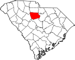
Fairfield County, South Carolina Basics:


Fairfield County South Carolina - Government Site

Population: 23,338
Area: 686 square miles
County seat: Winnsboro
Area code(s) in use: 803
Time zone: EST
High school graduate or higher: 80.1%
Bachelor's degree or higher: 15.1%
Median household income: $35,452
Persons in poverty: 23.2%
Home ownership rate: 72.8%
Mean travel time to work: 27.9 minutes


Adjacent counties:
Chester  Kershaw  Lancaster  Newberry  Richland  Union  

Find in South Carolina

Map of the Fairfield County area


Our detail map of Fairfield County shows the Fairfield County, South Carolina boundary lines and other interesting items.

Places in Fairfield County, South Carolina

  Airports     show all on map

Fairfield County Airport, Summers Station Heliport

  Bridges     show all on map

Bells Bridge, Browns Bridge, Glenns Bridge

  Buildings     show all on map

Cedar Creek Power Plant, Fairfield County Emergency Medical Services, Fairfield County Fire Department Blackstock - Woodward, Fairfield County Fire Department Blair, Fairfield County Fire Department Community, Fairfield County Fire Department Community Substation, Fairfield County Fire Department Dutchman Creek, Fairfield County Fire Department Feasterville, Fairfield County Fire Department Greenbrier Bethel, Fairfield County Fire Department Greenbrier Substation, Fairfield County Fire Department Jenkinsville, Fairfield County Fire Department Lebanon, Fairfield County Fire Department Mitford, Fairfield County Fire Department Ridgeway, Fairfield County Fire Department Southeastern, Fairfield County Jail, Fairfield County Library, Featerville Community Center (historical), Parr Shoals Power Plant, Ridgeway Police Department, Winnsboro Fire Department

  Cemeteries     show all on map

Aimwell Cemetery, Aimwell Cemetery, Antioch Cemetery, Antioch Cemetery, Beaver Creek Cemetery, Bethel Cemetery, Bethesda Cemetery, Bethlehem Cemetery, Brick Cemetery, Calvary Cemetery, Castles-Stevenson Cemetery, Charles Cemetery, Coleman Cemetery, Concord Cemetery, Cool Branch Cemetery, Dennis Crosby Cemetery, Fairfield Cemetery, Feaster Cemetery, Friendship Cemetery, Gibson Cemetery, Gladney Cemetery, Greenbrier Cemetery, James Ashford Cemetery, Lebanon Cemetery, Little River Cemetery, Longtown Cemetery, Mann Cemetery, Milling Crossroad Cemetery, Mobley Cemetery, Molly Alston Cemetery, Monticello Cemetery, Mount Olive Cemetery, Mount Olivet Cemetery, Mount Zion Cemetery, New Buffalo Cemetery, New Hope Cemetery, Oaklawn Cemetery, Old Stone Church Cemetery, Owens Cemetery, Pearson Cemetery, Piney Grove Cemetery, Richardson Cemetery, Richmond Covenanter Cemetery, Roberts Cemetery, Robinson Cemetery, Rock Creek Cemetery, Ross Memorial Gardens Cemetery, Russell Cemetery, Saint James Cemetery, Saint Johns Cemetery, Saint Stephens Cemetery, Salem Cemetery, Sawneys Creek Cemetery, Shelton-Shivar Cemetery, Shiloh Cemetery, Shiloh Cemetery, Shiloh Cemetery, Thomas Woodward Cemetery, Turner Cemetery, Union Cemetery, Van Cemetery, Weeping Mary Cemetery, White Oak Cemetery, Wiley Coleman Cemetery, Winnsboro Mills Cemetery, Wirick Cemetery, Yarborough Cemetery

  Census     show all on map

Winnsboro Mills Census Designated Place

  Churches     show all on map

Aimwell Church, Antioch Church, Antioch Church, Beaver Creek Church, Bethel Associate Reformed Presbyterian Church, Bethel Church, Bethel Church, Bethesda African Methodist Episcopal Zion Church, Bethesda Church, Bethlehem Church, Black Jack Church, Browns Chapel, Calvary Church, Church of God, Church of God, Church of the Nazarene, Concord Church (historical), Cool Branch Baptist Church, Cool Branch Church, County Grove Church, Crooked Run Church, Ebenezer Church, Elizabeth Church (historical), Fairfield Church, Fairview Church, First Baptist Church, Friendship Church, Gethsemane Church, Gibson Meeting House (historical), Gladden Grove Church, Good Hope Church, Greenbrier Church, Hassion Hill Church, Hebron Church, Holiness Church, Holy Sanctified Baptist Church (historical), Lebanon Presbyterian Church, Liberty Universal Church, Little Mission Church, Little River Church, Little River Church, Longtown Church, Macedonia Church, Mitford Church (historical), Monticello Methodist Church, Morris Creek Church, Mount Moriah Church, Mount Moriah Church (historical), Mount Olive Church, Mount Olive Church, Mount Olivet Church, Mount Pilgrim Church, Mount Pisgah Church, Mount Visit Church, Mount Zion Church, Mount Zion Church, Mount Zion Church, Nazareth Church, New Haven Church, New Hope Church, New Hope Church, New Hope Church, New Zion Church, New Zion Church (historical), Oak Grove Church, Old Brick Church, Old Hope Station Church, Pine Grove Church, Pine Grove Church, Pleasant Grove Church, Purity Church, Red Hill Church, Rehoboth Church, Rock Creek Church, Rock Hill Church, Rock Hill Church, Rockton Church, Rulis Chapel, Saint Barnabas Church, Saint Johns Church, Saint Johns Church, Saint Johns Church, Saint Johns Episcopal Church, Saint Lukes Church, Saint Marks Church, Saint Marys Church (historical), Saint Matthews Church, Saint Matthews Church, Saint Paul Baptist Church, Saint Pauls Church, Saint Peters Church, Saint Stephens Church, Saint Theresa Church, Salem Church, Sawneys Creek Church, Shady Grove Church, Shiloh Church, Shiloh Church, Shiloh Church (historical), Shiloh Church (historical), Stephen Green Memorial Baptist Church, Sweet Prospect Church, The Church of Jesus Christ of Latter Day Saints, Union Memorial Church, Upper Hope Station Church, Waymaon Methodist Church, Weeping Mary Church, Weeping Mary Church, White Hall Church, White Oak Church, White Oak Church, White Oak Church, Winnsboro Mills Methodist Church, Zion Chapel (historical), Zion Church, Zion Church (historical), Zion Hopewell Church

  Crossings     show all on map

Dukes Ford (historical), Hancocks Old Ferry (historical), Hugheys Ferry (historical), Hunts Ford, Interchange 34, Interchange 41, Interchange 46, Interchange 48, Kingsburys Ferry (historical), Lyles Ford, Ruffs Ferry (historical)

  Dams     show all on map

Camp Longridge Lake Dam D-0534, Caughmans Duck Pond D-1572 Dam, Doctor Taylors Pond D-1570 Dam, Hawkins Pond D-1569 Dam, Jackson Mill Creek WCD Dam D-0523, Jackson Mill Creek WCD Dam Two D-0521, Macfie Pond D-1568 Dam, South Carolina Noname 20001 D-0529 Dam, South Carolina Noname 20002 D-0530 Dam, South Carolina Noname 20008 D-0525 Dam, South Carolina Noname 20010 D-0527 Dam, South Carolina Noname 20018 D-0535 Dam, South Carolina Noname 20019 D-0520 Dam, South Carolina Noname 20020 D-0532 Dam, South Carolina Noname 20021 D-0438 Dam, South Carolina Noname 20022 D-0528 Dam, South Carolina Noname 20023 D-0533 Dam, South Carolina Noname 20024 D-1571 Dam, South Carolina Noname 20025 D-1673 Dam, Wateree Creek WCD Dam Number Four D-0539, Wateree Creek WCD Dam Number One D-0536, Wateree Creek WCD Dam Number Three D-0538, Wateree Creek WCD Dam Number Two D-0537, Winnsboro Reservoir Dam D-0522

  Hospitals     show all on map

Fairfield Memorial Hospital

  Islands     show all on map

Hampton Island, Pearsons Island, Shelton Island

  Locales     show all on map

Bells Mill (historical), Camp Longridge, Camp Welfare, Elliots Mill (historical), Fort Wagener (historical), Fort Wagner Monument, Kincaids Mill (historical), Lees Old Mill (historical), Pickels Mill (historical), Rocky Branch Hunt Camp, Somers Mill (historical), South Sandy Boat Ramp, White Oak Conference Center

  Mines     show all on map

Anderson Quarry, Blair Quarry

  Parks     show all on map

Featerville Academy Historic District, Lake Wateree State Park, Ridgeway Historic District, Stevenson Park, White Oak Historic District

  Populated Places     show all on map

Adger, Alston, Biddle (historical), Blair, Bucklick, Clayton, Colonel Creek Landing, Cool Branch, Dawkins, Douglass, Dutchman Creek, Feasterville, Flint Hill, Gladden Grove (historical), Jenkinsville, Jennings, Lebanon, Longtown, Lylesford (historical), Mitford, Monticello, Old Buckhead, Parr, Richtex, Ridgeway, Rion, Rock Creek, Rock Hill, Rockton, Salem Crossroads, Shelton, Simpson, Smallwood, Stover, Strother, Sueville (historical), Taylors Creek, Wallaceville, White Oak, Winnsboro, Winnsboro Mills, Woodward

  Post Offices     show all on map

Winnsboro Post Office

  Rapidss     show all on map

Aldrichs Shoal (historical), Buck Shoals, Busbys Shoals, Chapels Shoals, Griffins Shoal, Powells Shoal

  Reservoirs     show all on map

Camp Longridge Lake, Jackson Mill Creek Watershed Structure Number One, Jackson Mill Creek Watershed Structure Number Two, Monticello Reservoir, Wateree Creek Conservation District Reservoir, Wateree Creek Watershed Structure Number Four, Wateree Creek Watershed Structure Number Three, Wateree Creek Watershed Structure Number Two, Wateree Lake, White Oak Conference Center Lake, Winnsboro Reservoir

  Schools     show all on map

Aimwell School (historical), Bethel School (historical), Bethlehem School (historical), Black Jack School (historical), Broad River School (historical), Calvary School (historical), Centerville School (historical), Elizabeth School (historical), Everett School, Fairfield County Training School (historical), Fairfield County Vocational Center, Fairview School (historical), Featerville Male and Female Academy (historical), Geiger School, Gethsemane School (historical), Gladden Grove School (historical), Gordon School, Greenbrier School, Gritts School (historical), Hessian Hill School (historical), Hope Station School (historical), Kelly Miller School, Langford School (historical), Leitner Grove School (historical), Mathis School (historical), McCrorey Liston School, Mitford School, Monticello High School (historical), Mount Olive School (historical), Mount Olivet School (historical), Mount Pilgrim School (historical), Mount Visit School (historical), Mount Zion College (historical), Mount Zion Institute, Mount Zion School (historical), New Hope School (historical), New Zion School (historical), New Zion School (historical), Oak Grove School, Piney Grove School (historical), Piney Grove School (historical), Purity School (historical), Richard Winn Academy, Rock Hill School (historical), Rocky Creek School (historical), Saint Barnabas School (historical), Saint Holiness School (historical), Saint John School (historical), Saint Mark School (historical), Saint Matthews School (historical), Saint Peters School (historical), Shady Grove School (historical), Shiloh School (historical), Shiloh School (historical), Sweet Prospect School (historical), Thorn School (historical), Thorntree School (historical), Turner School (historical), Union School (historical), Wallaceville School (historical), White Hall School, White Oak School (historical), Winnsboro High School, Woodward School (historical)

  Streams     show all on map

Beaver Creek, Bell Creek, Big Wateree Creek, Brushy Fork Creek, Camp Branch, Catawba River, Cedar Fork, Center Creek, Chappel Branch, Chicken Creek, Colonel Creek, Cool Branch, Crooked Creek, Crumpton Creek, Debutary Creek, Dumpers Creek, Dutchmans Creek, Fox Creek, Frees Creek, Freshley Branch, Gaydens Creek, Gibson Branch, Gladney Branch, Glovers Branch, Harden Branch, Hellers Creek, High Hill Creek, Hill Creek, Hogfork Branch, Horse Branch, Horse Creek, Hunts Branch, Jackson Creek, Jordan Branch, Kennedy Creek, Lick Branch, Little Wateree Creek, Lots Fork, Manns Branch, Mayo Creek, McClures Creek, McCulley Creek, Mile Branch, Mill Creek, Minton Creek, Mobley Creek, Moore Creek, Morris Creek, Neckleys Creek, Old Ridge Branch, Opossum Branch, Persimmon Fork, Ready Creek, Reedy Branch, Robinson Branch, Rochelle Creek, Rock Dam Creek, Rocky Branch, Rocky Creek, Russell Creek, Sand Creek, Sandy Fork, Scabbler Branch, Smith Branch, Spring Branch, Stitt Branch, Storm Branch, Taylor Creek, Thorntree Creek, Wall Creek, Weir Creek, West Fork Little River, White Oak Branch, Wilkinsons Creek, Williams Creek, Willow Swamp Branch, Winnsboro Branch, Woodward Branch

  Towers     show all on map

Shelton Lookout Tower, Simpson Lookout Tower, White Oak Lookout Tower, WINF-AM (Winnsboro),

Fairfield County, South Carolina Population By Race (2012 estimate)

RacePopulation
BlackFairfield County Black population 13,67613,676  
WhiteFairfield County White population 9,2429,241
MixedFairfield County Mixed population 280280
American IndianFairfield County American Indian population 7070
Hawaiian & Pacific IslanderFairfield County Hawaiian & Pacific Islander population 00

Additional population tables :
State population table
South Carolina population by county