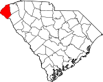
Oconee County, South Carolina Basics:


Oconee County South Carolina - Government Site

Population: 74,628
Area: 626 square miles
County seat: Walhalla
Area code(s) in use: 864
Time zone: EST
High school graduate or higher: 82.5%
Bachelor's degree or higher: 21.6%
Median household income: $41,854
Persons in poverty: 19.2%
Home ownership rate: 74.7%
Mean travel time to work: 24.0 minutes


Adjacent counties:
Anderson  Franklin (GA)  Habersham (GA)  Hart (GA)  Jackson (NC)  Pickens  Rabun (GA)  Stephens (GA)  Transylvania (NC)  

Find in South Carolina

Map of the Oconee County area


Our detail map of Oconee County shows the Oconee County, South Carolina boundary lines and other interesting items.

Places in Oconee County, South Carolina

  Airports     show all on map

Anna's Airport, Eagle Ridge Airport, Hawks Nest Farm Airport, Oconee County Regional Airport, US Army Reserve Center-Clemson Heliport

  Areas     show all on map

Lee Falls Special Area

  Bars     show all on map

Cleveland Shoal (historical), Harris Shoal (historical), Woodall Shoals

  Beaches     show all on map

East Beach

  Bends     show all on map

Fork Bottom Bend, Horseshoe Bend, Pickens Bend

  Bridges     show all on map

Blackwell Bridge, Cassidy Bridge, Chapman Bridge, Cherrys Bridge, Cobbs Bridge, Davis Bridge, Emerson Bridge, Flat Shoals Bridge, Highway 76 Bridge, Horseshoe Bridge, Hunnicut Bridge, Jarrett Bridge (historical), Jenkins Bridge, Knox Bridge (historical), Land Bridge, Lawrence Bridge, Maxwell Bridge, Nimmons Bridge, Nimmons Bridge (historical), Old Pickens Bridge, Prather Bridge, Ramsey-Jarrett Bridge, Russell Bridge, Tanyard Bridge

  Buildings     show all on map

Andrew Pickens Ranger Station, Chattooga River Information Center, Lonsdale Mill Power Plant, Oakway Fire Department Station 1, Oconee County Courthouse, Oconee County Jail, Oconee County Library, Oconee County Rural Fire Department, Oconee County Rural Fire Department Cleveland, Oconee County Rural Fire Department Corinth Shiloh, Oconee County Rural Fire Department Crossroads, Oconee County Rural Fire Department Fair Play, Oconee County Rural Fire Department Friendship, Oconee County Rural Fire Department Keowee, Oconee County Rural Fire Department Keowee Ebenezer, Oconee County Rural Fire Department Keowee Key, Oconee County Rural Fire Department Long Creek, Oconee County Rural Fire Department Mountain Rest, Oconee County Rural Fire Department Oak Way, Oconee County Rural Fire Department Pickett Post Camp Oak, Oconee County Rural Fire Department Salem, Oconee County Rural Fire Department Seneca, Oconee County Rural Fire Department South Union, Oconee County Rural Fire Department Walhalla, Oconee County Rural Fire Department West Union, Oconee County Rural Fire Department Westminster, Oconee Medical Center Emergency Medical Services, Seneca City Hall, Seneca Police Department, Walhalla City Hall, Walhalla Police Department, West Union Police Department, Westminster Branch Library, Westminster City Hall, Westminster Fire Department, Westminster Police Department

  Cemeteries     show all on map

Alexander Cemetery, Belmont Cemetery, Bethel Cemetery, Bethel Cemetery, Bethlehem Cemetery, Brasstown Cemetery, Cary Cemetery, Chauga Cemetery, Cherry Hill Cemetery, Collins Cemetery, Coneross Cemetery, Crossroad Cemetery, Damascus Cemetery, Duke Cemetery, Evergreen Memorial Gardens, Fall Creek Cemetery, Flat Rock Cemetery, Green Cemetery, Hays Cemetery, Hepsibah Cemetery, High Falls Cemetery, Hopewell Cemetery, Isaqueena Cemetery, Kesse Cemetery, Laurel Springs Cemetery, Lutheran Cemetery, Marit Cemetery, Monte Vista Cemetery, Moody Cemetery, Mount Carmel Cemetery (historical), Mount Pleasant Cemetery, Mount Tabor Cemetery, Mount View Cemetery, Mountain Grove Cemetery, Mountain View Cemetery, Nazareth Cemetery, New Foundation Cemetery, New Hope Cemetery, New Promised Land Cemetery, Oak Grove Cemetery, Oakway Cemetery, Oconee Memorial Gardens, Old Liberty Cemetery, Old New Hope Cemetery, Old Pickens Cemetery, Oponee Memorial Gardens, Pells Cemetery, Piney Grove Cemetery, Pleasant Grove Cemetery, Pleasant Hill Cemetery, Pleasant Ridge Cemetery, Poole Cemetery, Poplar Springs Cemetery, Richland Cemetery, Rider Mountain Cemetery, Rock Springs Cemetery, Rocky Fork Cemetery, Rocky Knoll Cemetery, Rogers Cemetery, Ross Cemetery, Snyder Cemetery, South Union Cemetery, Stamp Creek Cemetery, Stewart Cemetery, Stribbling Cemetery, Toxoway Cemetery, Unity Cemetery, Westview Cemetery, Whitmere Cemetery, Wildwood Memorial Park, Winchester Cemetery, Wolf Pit Cemetery, Wolf Stake Cemetery

  Census     show all on map

Fair Play Census Designated Place, Newry Census Designated Place, Utica Census Designated Place

  Churches     show all on map

Adison Church, Beaverdam Baptist Church, Belmont Baptist Church, Bethel Baptist Church, Bethel Church, Bethel Church (historical), Bethel Church (historical), Bethlehem Baptist Church, Blue Ridge Church, Boones Creek Church, Bounty Land Baptist Church, Brasstown Baptist Church, Calvary Church, Calvary Church, Canon Church, Center Church, Chauga Baptist Church, Cheohee Baptist Church, Cheohee Baptist Church, Cheohee Cemetery, Cherry Hill Church, Church of God, Church of God, Church of God, Church of God, Clearmont Baptist Church, College Street Baptist Church, Coneross Baptist Church, Corinth Baptist Church, Corinth Baptist Church, Cross Roads Baptist Church, Crossroad Baptist Church Number 2, Crossroad Church, Damascus Baptist Church, Double Springs Baptist Church, Double Springs Church, Earles Grove Baptist Church, Ebenezer Baptist Church, Ebenezer Baptist Church, Emmanuel Church, Emmanuel Church, Episcopal Church of the Ascension, Fair Play Presbyterian Church, Fairview Church, Fall Creek Baptist Church, First Baptist Church, First Church of Christ Scientist, Flat Rock Baptist Church, Freedom Church, Friendship United Methodist Church, Galilee Methodist Episcopal Church (historical), Hepsibah Baptist Church, High Falls Church, Holly Springs Church, Hopewell Baptist Church, Hopewell Church, Isaqueena Church, John Wesley Methodist Episcopal Church (historical), Laurel Spring Church, Little River Baptist Church, Long Mountain Church, Monte Vista Baptist Church, Morgan Memorial Church, Mount Carmel Church, Mount Carmel Church, Mount Carmel Church (historical), Mount Nebo Baptist Church, Mount Olive Church, Mount Pleasant Baptist Church, Mount Sinai Church (historical), Mount Tabor Baptist Church, Mount Vernon Church, Mount Zion Holiness Church, Mountain Grove Baptist Church, Mountain Rest Baptist Church, Mountain Spring Church, Mountain View Church, Nazareth Church, Nebo Church (historical), New Foundation Church (historical), New Galilee Baptist Church, New Harmony United Methodist Church, New Hope Baptist Church, New Promised Land Church, Oakway Church, Old Hepsibah Baptist Church, Old Liberty Baptist Church, Old Madison Church, Old Pickens Church, Old Retreat Church, Old Stone Church, Owens Chapel, Pleasant Grove Baptist Church, Pleasant Hill Baptist Church, Pleasant Hill Baptist Church, Pleasant Ridge Baptist Church, Poplar Springs Baptist Church, Providence Church, Reedy Fork Baptist Church, Retreat Baptist Church, Return Baptist Church, Richland Church, Richland Church, Rider Mountain Church, Rock Hill Church, Rock Hill Church, Rock Springs Church, Rocky Fork Baptist Church, Rocky Knoll Baptist Church, Round Mountain Church (historical), Saint Annes Church, Saint Francis Catholic Church, Saint Johns Evangelical Lutheran Church, Saint Marks Church, Saint Matthew Baptist Church, Saint Paul Baptist Church, Saint Peters Church, Salem Davidian Church, Seneca Baptist Church, Seneca Methodist Episcopal Church, Seneca Presbyterian Church, Shiloh Church, Shiloh Church, Snow Creek Church, South Union Baptist Church, Stamp Creek Baptist Church, Tabernacle Holiness Church (historical), Tamassee Daughters of the American Revolution Church, Toxaway Baptist Church, Toxaway Church (historical), Travelers Rest Church, Trinity Baptist Church, Trinity Methodist Church, Tugaloo Church, Tugaloo Church, Unity Baptist Church, Walhalla Methodist Church, Walhalla Presbyterian Church, Walhalla Wesleyan Methodist Church, Welcome Church, Welcome Wesleyan Church, West Union Church (historical), Westminster Baptist Church, Westminster Presbyterian Church, Westminster United Methodist Church, Westminster Wesleyan Church, Whitewater Church (historical), Whitmire Church, Williams Street Church of Christ, Wolf Stake Baptist Church, Zion Church, Zion Church

  Crossings     show all on map

Andersons Ferry (historical), Cleveland Ferry (historical), Interchange 1, Interchange 2, Jenkins Ferry (historical), Long Bottom Ford, Mullens Ford (historical), Nicholas Ford, Pickens Ferry (historical), Ramsey Ferry (historical), Robertsons Ford, Rocky Ford, Rouges Ford, Shelor Ferry (historical), Stribling Ferry (historical), Waltons Ford (historical)

  Dams     show all on map

Adams Pond Dam D-1654, Beaverdam Creek WCD Dam Number Five D-1665, Beaverdam Creek WCD Dam Number Four D-1667, Beaverdam Creek WCD Dam Number Two D-1666, Bookers Lake Dam D-1646, Chattooga Lake Dam D-1637, Coneross Creek D-1654 Dam, Coneross Creek WCD Dam Number 21 D-1656, Coneross Creek WCD Dam Number Eight D-1653, County Country Club Pond Dam D-1658, Crystal Lake Dam D-1645, Duke Power Dam, Freeman Pond Dam D-1662, Gordons Lake Dam D-1640, Harper Pond Dam D-1661, Hicks Pond Dam D-1659, Horseshoe Lake Dam D-1650, Jocassee Dam, Johns Pond Dam D-1663, Keaslers Pond Dam D-1630, Lake Cheohee Dam D-1632, Lake Jemike Number One Dam D-1648, Lake Jemike Number Two Dam D-1649, Lake Leroy Dam D-1639, Little River Dam, Mountain Lake Dam D-1641, Mountain Rest Lake Dam D-1638, Nickols Pond Dam D-1660, Oconee State Park Dam Number One D-1642, Rochester Craven Dam D-1633, Rochester Little Lake Dam D-1523, Roletter Pond Dam D-1664, South Carolina Noname 37011 D-1651 Dam, South Carolina Noname 37024 D-1635 Dam, South Carolina Noname 37026 D-1631 Dam, South Carolina Noname 37030 D-1644 Dam, South Carolina Noname 37031 D-1643 Dam, Stephens Coneross Dam, Townes Creek Dam D-1634, Tugaloo Dam, Walhalla Reservoir Dam D-1647, Webbs Pond Dam D-1657, Whitewater Lake Dam D-1636

  Falls     show all on map

Hidden Falls, High Falls, Isaqueena Falls, Kings Creek Falls, Lower Falls, Spoonauger Falls

  Gaps     show all on map

Callas Gap, Hi Saw Gap, Hickory Gap, Line Rock Gap, Mongold Gap, Reed Mountain Gap, Rocky Gap

  Hospitals     show all on map

Blue Ridge Surgery Center, Oconee Medical Center, Shady Brook Hospital, Upstate Pain Management and Surgery Center

  Lakes     show all on map

Cox Pond, Turn Hole

  Locales     show all on map

Applewood Shopping Center, Bakers Mill (historical), Brysons Apple Orchard, Burrel Place Campground, Burrells Ford Campground, Camp Jocassee, Camp Jocassee (historical), Cane Creek Landing, Cassidy Bridge Campground, Cedar Creek Rifle Range, Chattooga Belle Farm, Chattooga Picnic Area, Cherry Hill Recreation Site, Church Campground, Dogwood Plaza Shopping Center, Earls Ford Recreation Site, Gates Store (historical), Hemlock Club (historical), Highway 28 Recreation Site, Holdins Mill (historical), Humphreys Mill (historical), Keith Quarter, Keowee Marina, Keowee Village Shopping Center, Kings Mill (historical), Knox Store, Lonsdale Mill, Mina-Tonka Lodge (historical), Moody Spring Campground, Mountain Rest, Oconee Country Club, Oconee Square Shopping Center, Oconee Station, Old Retreat, Piedmont State Nursery, Pine Mountain Hunt Camp, Pitts Mill (historical), River View Lodge (historical), Rose Bud Picnic Area, Round Mountain Apple Orchard, Scenic Plaza Shopping Center, Seneca Marina, Simpson Store, Sloan Bridge Campground, Snead Mill (historical), Southgate Shopping Center, Swaneys Landing, Tri-State Club (historical), Village Creek Mission, Walhalla Filtration Point, Walhalla Fish Hatchery, White Rock Scenic Area, Wilsons Landing, Woodall Shoals Recreation Site, Wrights Siding, Yellow Branch Campground

  Mines     show all on map

Bee Cove Creek Prospect, John O'Leary Prospect

  Parks     show all on map

Chauga River Scenic Area, Colonel Cleveland Monument, DAR Monument, General Pickens Monument, Hopewell-Keowee Monument, Newry Historic District, Oconee State Park, Seneca Historic District, Station Creek Cove Botanical Area, Treaty Oak Monument

  Populated Places     show all on map

Adams Crossing, Avondale, Battle Creek, Bay Shores, Bent Tree, Bishop Heights, Boones Creek, Bounty Land, Brasstown, Brock, Brookwood, Burns Mill, Caballin Springs, Camp Oak, Chagee (historical), Chauga Heights, Cheohee, Cherokee Gardens, Cherrys Crossing, Clearmont, Clemson Forest, Cleveland-A-Farm, Clovis Point, Colonial Heights, Colonial Place, Conneross (historical), Corinth, Country Villa Subdivision, Courtenay, Cove Inlet, Cross Roads, Crystal Falls, Dalton, Dixon Crossroads, Dogwood Heights, Doris Heights, Dutch Fork, Earles Grove, Eastcliff, Eastminster, Ebenezer, Eleven Oaks, Enchanted Hills, Ensenaka (historical), Fair Play, Fairplay Shores, Fairview, Fairview Shores, Fall Creek, Fernwood Acres, Five Points, Flat Shoals, Forest Acres, Forest Hills, Fox Run, Friendship, Friendship Shores, George Martin Acres, Gilstrap, Greenbriar, Grover Square, Hampton Shores, Hanover Hills, Harbin (historical), Harbin Acres, Hicks Store, Holly Springs, Horse Shoe (historical), Indian Hills, Indian Oaks, Jason, Jocassee, Jocassee (historical), Johns Mill, Jordonia, Keowee, Keowee (historical), Keowee Haven, Keowee Plantation, Keowee Shores, Knoll Wood Manor, Kulsetsiyi (historical), Lake Barcroft Acres, Lakeside Estates, Lakeside Mobile Home Park, Lakeview Heights, Long Bottom Ford, Longcreek, Loran Point, Madison, Martindale, Millbrook, Moody Cove, Morningside Heights, Mylintee Estates, Newry, Normandy Shores, Oakmont, Oakway, Oconee (historical), Oconee Estates, Oconee Point, Old Madison, Old Pickens, Oxford, Percival Crossroads, Phinney, Picket Post, Poplar Cove, Poplar Springs Ridge, Port Bass, Port Santorini, Rackley, Retreat, Return, Richland, Ridgeland Estates, Ridgeview, Ridgewood, Royal Acres, Russell (historical), Salem, Saxony Forest, Seneca, Seneca (historical), Seneca Landing, Seven Oaks, Shadwick, Shiloh, Shiloh Estates, Singing Pines, Snug Harbor, South Cove, South Union, Southern Meadows, Spring Valley, Springbrook, Springdale, Stone Haven, Sugar Hill, Sunset Shores, Tabor, Tamassee, The Meadows, The Woods, Thriftwood, Timberlake, Tokeena Point, Tomassee (historical), Tsiyahi (historical), Ustanli (historical), Utica, Valley View, Valley View Shores, Village Creek, Vista Grove, Walhalla, Walnut Grove, Water Plantation, West Union, Westminster, Wexford, Whetstone, White Harbor, White Oak Cliffs, Woodburn, Woodcreek, Woodfarm Acres, Woodland Acres, Woodland Trailer Park

  Post Offices     show all on map

Jocassee Post Office (historical), Pickett Post Office (historical), Seneca Post Office, Walhalla Post Office, West Union Post Office, Westminster Post Office

  Rapidss     show all on map

Big Shoals

  Reserves     show all on map

Ellicott Rock Wilderness

  Reservoirs     show all on map

Ables Pond, Adams Pond, Adams Pond, Barrett Pond, Beaverdam Watershed Five Lake, Beaverdam Watershed Four Lake, Bookers Lake, Broom Pond, Browns Lake, Browns Lake, Butts Pond, Chattooga Lake, Collins Lake, Coneross Creek Reservoir, Coneross Creek Reservoir, Coneross Watershed 21 Reservoir, Coneross Watershed 9-A Reservoir, Crystal Lake, Crystal Lake, Dickson Lake, Freeman Pond, Gibson Pond, Gordons Lake, Harper Pond, Harper Pond, Hattooga Lake, Hicks Pond, Horseshoe Lake, Johns Pond, Johns Pond, Keaslers Pond, Lake Becky, Lake Cheohee, Lake Cherokee, Lake Cherokee, Lake Front Homes Pond, Lake Isaquenna, Lake Jemike, Lake Jocasse, Lake Jocassee, Lake Keowee, Lake Keowee, Lake Leroy, Lake Yonah, Mahaffey Lake, Marritt Pond, McMahons Mill Pond (historical), Miller Pond, Mitchells Lake, Mountain Rest Lake, Mountain Rest Lake, Negro Fork Reservoir, Nickols Pond, Oconee State Park Lake Number One, Parker Lakes, Peters Pond, Prater Pond, Ramsey Pond, Reids Pond, Rochester Lake Number One, Rochester Lake Number Two, Roletter Pond, Sanders Lake, Seneca Reservoir, Smith Pond, Smith Pond, Spearman Pond, Sumter National Forest Lake, Tugaloo Lake, Varnadore Pond, Walhalla Reservoir, Walhalla Reservoir, Webb Lake, Webb Pond, Webbs Pond, Whitewater Lake, Whitewater Lake, Wingos Lake

  Ridges     show all on map

Chattooga Ridge, Slatten Ridge

  Schools     show all on map

Bear Pen School (historical), Bethlehem School (historical), Block School Number 2 (historical), Blue Ridge High School, Blue Ridge School (historical), Blue Ridge School (historical), Boone Creek School Number 1 (historical), Boone Creek School Number 2 (historical), Boones Creek School (historical), Bounty Land School (historical), Bounty Land School (historical), Brasstown School (historical), Chattooga School, Cherry Hill School (historical), Clairmont School (historical), Clemson University, Cleveland School, Corinth School (historical), Crawford School (historical), Damascus School (historical), Earles Grove School (historical), Ebenezer High School (historical), Fair Play Elementary School, Fair Play School (historical), Fair Play-Oakway School, Fairfield School (historical), Fairview School (historical), Fort George School (historical), Friendship School (historical), Friendship School Number 1 (historical), Friendship School Number 2 (historical), Gignillial Park Elementary School, Hillcrest School, Holly Springs School, Isaqueena School Number 1 (historical), Isaqueena School Number 2 (historical), Jocassee School (historical), Keowee High School, Keowee School (historical), Little River School (historical), Long Creek Academy (historical), Long Creek School (historical), Madison School (historical), Mill Creek School (historical), Mountain Grove School (historical), Mountain Rest School, Neville School (historical), New Hope School, Newry Corinth School, Northside School, Norton School (historical), Oak Grove School (historical), Oakway Elementary School, Oakway Middle School, Oakway School (historical), Oconee Creek School (historical), Oconee Station School (historical), Oconee Vocational Center, Pine Street Elementary School, Poplar Springs School (historical), Providence School (historical), Providence School (historical), Ravenel Elementary School, Reedy Fork School (historical), Retreat School (historical), Retreat School (historical), Return School (historical), Return School (historical), Rich Mountain School (historical), Richland School (historical), Round Mountain School (historical), Seneca High School, Seneca Preschool, Shiloh School (historical), Shiloh School (historical), Smeltzer School (historical), Snow Creek School (historical), South Union School (historical), South Union School (historical), Southside School, Tamassee DAR School, Tamassee/Salem Middle-High School, Tokeena School (historical), Union School (historical), Utica Elementary School, Victor Monaghan School (historical), Village Creek School (historical), Walhalla Elementary School, Walhalla Graded School (historical), Walhalla Graded School (historical), Walhalla High School, Walhalla Middle School, West-Oak High School, Westminster Elementary School, Westminster Middle School, Westminster Preschool, Westminster Public School (historical), Westminster School (historical), Zion School (historical)

  Springs     show all on map

Moody Spring

  Streams     show all on map

Alexander Creek, Bad Creek, Bad Creek, Bad Creek, Baker Branch, Barbecue Branch, Barkshed Branch, Barton Creek, Barton Creek, Battle Creek, Beaman Branch, Bear Creek, Bearcamp Creek, Beaty Creek, Bee Creek, Betty Branch, Big Branch, Big Branch, Big Creek, Big Stakey Creek, Boatwright Creek, Bone Camp Creek, Boones Creek, Brasstown Creek, Burgess Creek, Camp Bottom Branch, Camp Branch, Cane Creek, Caney Branch, Cantrell Creek, Cater Branch, Cedar Creek, Chambers Branch, Chattooga River, Chauga River, Cheohee Creek, Cherry Cove Branch, Choestoea Creek, Clear Branch, Cleveland Creek, Cobb Creek, Coley Creek, Colonels Fork Creek, Coppermine Branch, Corbin Creek, Cornhouse Creek, Crane Creek, Craven Creek, Crooked Creek, Crooked Creek, Crossland Creek, Crow Creek, Daniel Branch, Dark Branch, Davis Branch, Devil Hole Branch, Devils Branch, Devils Fork, Devils Fork Creek, Dodgens Creek, Doran Creek, Double Branch, Double Branch, Drummond Creek, East Fork Chattooga River, East Longnose Creek, East Toxaway Creek, East Village Creek, Fair Play Creek, Fall Creek, Fall Creek, Fiddlers Creek, Findley Branch, Fishtrap Branch, Flat Shoals River, Flint Creek, Frenge Branch, Grapevine Branch, Gryer Branch, Halfway Branch, Harbin Creek, Harts Branch, Hell Hole Creek, Hickory Flat Branch, Horse Bone Branch, Horsepasture River, Howard Creek, Indian Camp Branch, Ira Branch, Jacks Creek, Jerry Creek, Joe Branch, Jumping Branch, Kelly Creek, Keowee River, King Creek, Knox Creek, Laurel Creek, Lee Branch, Lick Log Creek, Limber Pole Creek, Limestone Creek, Little Brasstown Creek, Little Cane Creek, Little Choestoea Creek, Little Longnose Creek, Little River, Little Toxaway Creek, Long Branch, Long Branch, Long Branch, Long Creek, Longnose Creek, Martin Creek, McKinneys Creek, Mile Creek, Mill Branch, Mill Creek, Mill Creek, Mill Creek, Miller Field Branch, Moody Creek, Moss Mill Creek, Mud Creek, Mud Creek, Muddy Creek, Neal Branch, Negro Fork, North Fork Fall Creek, Oconee Creek, Opossum Creek, Orchard Branch, Orrs Mill Creek, Otter Creek, Pack Branch, Perkins Creek, Persimmon Branch, Pigpen Branch, Pinckney Branch, Porter Branch, Ramsey Creek, Reece Branch, Reedy Branch, Rhoda Branch, Richland Creek, Rocky Fork, Sand Branch, Sawhead Branch, Sawyer Branch, Seneca Creek, Shiloh Branch, Shingle Mill Branch, Shoulder Bone Branch, Sixmile Creek, Slatten Branch, Smeltzer Creek, Snow Creek, Sourwood Branch, Speeds Creek, Spider Valley Creek, Spy Rock Creek, Stamp Creek, Station Creek, Stump Branch, Sugar Creek, Swaford Creek, Tamassee Creek, Taylor Creek, Thompson River, Tilly Branch, Todd Branch, Townes Creek, Toxaway Creek, Turpin Branch, Tyler Branch, Village Creek, Von Hollen Creek, Wallace Branch, Wash Branch, West Fork Crane Creek, West Toxaway Creek, West Village Creek, Whetner Branch, Whetstone Creek, Whetstone Creek, White Fork, White Oak Creek, White Rock Creek, Whitewater River, Williams Creek, Wilson Branch, Wilson Creek, Woodall Branch, Wright Creek, Yarborough Branch, Yellow Branch

  Summits     show all on map

Big Stakey Mountain, Boast Mountain, Boatwright Mountain, Buck Knob, Burrells Mountain, Buzzard Roost Mountain, Callas Mountain, Cantrell Mountain, Crane Mountain, Crossroads Mountain, Dodge Mountain, Double Spring Mountain, Fisher Knob, Fork Mountain, Gallbuster Mountain, Grassy Mountain, Hester Mountain, Hickory Top, Hurricane Mountain, John Mountain, Licklog Mountain, Limber Pole Mountain, Little Stakey Mountain, Long Mountain, Long Mountain, Longnose Mountain, Lydia Mountain, McKinney Mountain, McKinneys Mountain, Medlin Mountain, Mill Mountain, Morton Mountain, Moss Mountain, Musterground Mountain, Nancy Long Mountain, Oconee Mountain, Old Field Mountain, Persimmon Mountain, Pine Mountain, Piney Knob, Piney Mountain, Poor Mountain, Reed Mountain, Rich Mountain, Rider Mountain, Ridley Mountain, Rockhouse Mountain, Ross Mountain, Round Mountain, Round Top, Russell Mountain, Smeltzer Mountain, Steps Mountain, Stumphouse Mountain, Tamassee Knob, Tater Hill, Tommys Knob, Tunnel Hill, Turnip Top, Wells Mountain, Whetstone Mountain, White Rock Knob, Whitewater Mountain

  Towers     show all on map

Clemson Lookout Tower, Long Creek Lookout Tower, Long Mountain Lookout Tower, Long Mountain Lookout Tower, WBFM-FM (Seneca), WGOG-AM (Walhalla), WSNW-AM (Seneca), Yellow Branch Lookout Tower

  Trails     show all on map

Foothills Trail, Winding Stairs Trail

  Tunnels     show all on map

Middle Tunnel, Saddle Tunnel, Stumphouse Mountain Tunnel,

Oconee County, South Carolina Population By Race (2012 estimate)

RacePopulation
WhiteOconee County White population 66,94166,941  
BlackOconee County Black population 5,7465,746
MixedOconee County Mixed population 1,1191,119
AsianOconee County Asian population 597597
American IndianOconee County American Indian population 224223
Hawaiian & Pacific IslanderOconee County Hawaiian & Pacific Islander population 00

Additional population tables :
State population table
South Carolina population by county