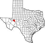
Crane County, Texas Basics:


Crane County Texas - Government Site

Population: 4,573
Area: 785 square miles
County seat: Crane
Area code(s) in use: 432
Time zone: CST
High school graduate or higher: 71.7%
Bachelor's degree or higher: 13.9%
Median household income: $49,974
Persons in poverty: 16.5%
Home ownership rate: 81.4%
Mean travel time to work: 21.9 minutes


Adjacent counties:
Crockett  Ector  Midland  Pecos  Upton  Ward  Winkler  

Find in Texas

Map of the Crane County area


Our detail map of Crane County shows the Crane County, Texas boundary lines and other interesting items.

Places in Crane County, Texas

  Airports     show all on map

Crane County Airport, J-Bar Ranch Airport

  Buildings     show all on map

Crane County Jail, Crane County Library, Crane Volunteer Fire Department and Emergency Medical Service

  Cemeteries     show all on map

County South Cemetery, Crane Memorial Gardens

  Churches     show all on map

First Baptist Church, Good Shepherd Catholic Church, Tabernacle Baptist Church, United Pentecostal Church

  Flats     show all on map

Spudder Flats

  Hospitals     show all on map

Crane Memorial Hospital

  Lakes     show all on map

Juan Cordona Lake, Perkins Lake, Soda Lake

  Locales     show all on map

Davis Windmills, Dawson Windmills, East Well Windmill, East Windmill, Ell Long Ranch, Fielding Windmill, Glass and Everitt Ranch, Gulf Windmill, Hardland Windmill, Hidden Water Windmill, House Windmill, J Bar Ranch, Lea Ranch, McClain Windmill, Middle Windmill, Middle Windmill, New Well Windmill, New Windmill, North Adolph Windmill, North Windmill, Old Headquarters Windmills, Old House Windmill, Pee Wee Windmill, Pigman Windmill, R B Valley Windmill, R B Windmill, Red Windmill, Sand Camp, Sand Windmill, Smith Ranch, Two G Windmill, Williams Ranch, Windmill Number Five, Windmill Number Nine, Windmill Number Ten

  Oilfields     show all on map

Armer Oil Field, Atapco Oil Field, Bayview Oil Field, Block 31 Oil Field, C Bar Oil Field, Concho Bluff Oil Field, Crane Cowden Oil Field, Crawar Oil Field, Crossett Oil Field, Dune Oil Field, Edwards Oil Field, Lea Oil Field, McElroy Oil Field, Roberdeau Oil Field, Running W Oil Field, Sand Hills Oil Field, Sand Hills South Oil Field, Tucker Oil Field, Waddell Oil Field, Warren Gas Plant, West Sand Hills Oil Field

  Parks     show all on map

Crane County Park

  Populated Places     show all on map

Crane, Horsehead Crossing (historical), Tubbs Corner

  Post Offices     show all on map

Crane Post Office

  Reservoirs     show all on map

Big Tank

  Schools     show all on map

Crane Elementary School, Crane High School, Crane Middle School, Crane-Bethune School

  Springs     show all on map

Antelope Springs (historical), Natural Wells Springs, Wild Cherry Water Hole Spring

  Summits     show all on map

Hilltop

  Towers     show all on map

KAIR-FM (Crane)

  Valleys     show all on map

Landreth Draw, Mayfield Draw

  Wells     show all on map

Adams Well, Big South Well, Bullard Well, Center Well, Corner Well, Coyote Well, Cummins Well, Doodle Bug Well, Dunn Well, East Well, Hands Well, Highway Well, Kyle Well, Little South Well, Little Star Well, McElroy Well, Middle Henderson Well, North Henderson Well, Number Two Well, Russell Well, Salt Well, Sand Well, Sand Well, Schinery Well, South Henderson Well, West Well, Williams Well, Yates Well,

Crane County, Texas Population By Race (2012 estimate)

RacePopulation
WhiteCrane County White population 4,2624,262  
BlackCrane County Black population 169169
American IndianCrane County American Indian population 6464
MixedCrane County Mixed population 4645
AsianCrane County Asian population 3232
Hawaiian & Pacific IslanderCrane County Hawaiian & Pacific Islander population 00

Additional population tables :
State population table
Texas population by county