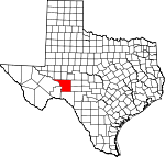
Crockett County, Texas Basics:


Crockett County Texas - Government Site

Population: 3,732
Area: 2807 square miles
County seat: Ozona
Area code(s) in use: 325
Time zone: CST
High school graduate or higher: 62.4%
Bachelor's degree or higher: 9.6%
Median household income: $49,850
Persons in poverty: 16.9%
Home ownership rate: 65.4%
Mean travel time to work: 16.5 minutes


Adjacent counties:
Crane  Irion  Pecos  Reagan  Schleicher  Sutton  Terrell  Upton  Val Verde  

Find in Texas

Map of the Crockett County area


Our detail map of Crockett County shows the Crockett County, Texas boundary lines and other interesting items.

Places in Crockett County, Texas

  Airports     show all on map

Ozona Municipal Airport, Perry Ranch Airport

  Buildings     show all on map

Crockett County Emergency Medical Services, Crockett County Museum, Crockett County Public Library, Ozona Volunteer Fire Department

  Cemeteries     show all on map

Cedar Hill Cemetery

  Census     show all on map

Ozona Census Designated Place

  Dams     show all on map

Soil Conservation Service Site 1 Dam, Soil Conservation Service Site 2 Dam, Soil Conservation Service Site 3 Dam, Soil Conservation Service Site 4 Dam, Soil Conservation Service Site 5 Dam, Soil Conservation Service Site 6 Dam, Soil Conservation Service Site 7 Dam

  Lakes     show all on map

Escondido Water Hole, Twin Lake

  Locales     show all on map

Adams Ranch, Alto Windmill, Antelope Windmill, Antone Windmill, Baggett Ranch, Baggett Ranch, Bailey Ranch, Bean Ranch, Big Indian Waterhole Windmill, Bill West Windmill, Bissett Ranch, Blakeney Ranch, Blue Ridge Windmill, Brooks Ranch, Buckhorn Ranch, Bunger Ranch, Canyon Windmill, Cedar Canyon Windmill, Clay Tank Windmill, Clayton Ranch, Clayton Ranch, Clayton Ranch, Coates Windmill, D K McMullan Ranch, Davidson Ranch, De Long Ranch, Devils River Windmill, Divide Windmill, Divide Windmill, Dog Canyon Windmill, Double Windmill, Dunlap Ranch, East Odom Windmill, East Windmill, Escondido Windmill, F McMullan Junior Ranch, Fields Ranch, Fogarty Ranch, Four Way Windmill, Friend Ranch, Glade Windmill, Glasscock Ranch, Glisa Windmill, Goat Windmill, Government Windmill, Hagelstein Ranch, Harvik Ranch, Henderson Windmill, Herrell Ranch, High Lonesome Stage Station, Hoover Ranch, House Windmill, Hunt Ranch, Hunt Ranch, Indian Waterhole Windmill, Indian Windmill, J Childress Ranch, Javelina Windmill, Kincaid Ranch, Lemmon Windmill, Lemon Windmill, Little Windmill, Lower Windmill, Marley Ranch, Maus Hog Windmill, McNutt Windmill, Mesquite Windmill, Middle Windmill, Middle Windmill, Mitchell Ranch, Mogul Ranch, Money Windmill, Montgomery Ranch, Murrah Windmill, New Well Windmill, New Windmill, Noelke Windmill, North Crockett Community Center, North Wilson Windmill, Odom Windmill, Oglesby Ranch, Old Ranch Windmill, Owens Ranch, Ozona Country Club, Patton Ranch, Perner Ranch, Phillips Ranch, Pierce Ranch, Pierce Ranch, Pikes Peak Windmill, Point Windmill, Prince Albert Windmill, R Childress Ranch, Ranchito Windmill, Read Ranch, Red Tail Windmill, Redman Camp, Road Windmill, Road Windmill, Rockwall Windmill, Santa Rosa Windmill, Schlinke Windmill, Seahorn Ranch, Six Section Windmill, South Odom Windmill, South Wilson Windmill, South Windmill, Star Divide Windmill, Star Windmill, Sulfur Windmill, Sulfur Windmill, Sulphur Trap Windmill, Sulphur Windmill, Sulphur Windmill, T and L Windmill, Telephone Windmill, Twelvefoot Windmill, Twelvemile Camp, Twenty-Five Foot Windmill, W Childress Ranch, Ward Ranch, Watson Ranch, West Divide Windmill, West Ranch, West Windmill, White Windmill, Whites Windmill, Wildcat Windmill, Wildcat Windmill, Wilkins Ranch, Williams Windmill, Yegua Windmill

  Military     show all on map

Ozona Air Force Station (historical)

  Oilfields     show all on map

Clara Couch Oil Field, Cox Oil Field, Crockett Oil Field, Elkhorn Oil Field, Escondido Oil Field, Farmer Oil Field, Halff Oil Field, Midway Lane Oil Field, Noelke Oil Field, Olson Oil Field, Ozona Gas and Oil Field, Shannon Oil Field, Simpson Oil Field, Tippett Gas Plant, Tippett Oil Field, Todd Deep Oil Field, Todd Oil Field, Vaughn Oil Field, Weger Oil Field, World Powell Oil Field, World West Oil Field

  Parks     show all on map

Fort Lancaster State Historical Park, Fort Lancaster State Historical Park

  Plains     show all on map

Edwards Plateau

  Populated Places     show all on map

Crockett Heights, Emerald (historical), Fort Lancaster, Four Corner Windmill, Hembrie (historical), Midway, Ozona

  Post Offices     show all on map

Ozona Post Office

  Reservoirs     show all on map

Clay Tank, Government Tank, Lost Tank, Pool Tank, Rock Tank, Round Mountain Tank, Soil Conservation Service Site 1 Reservoir, Soil Conservation Service Site 2 Reservoir, Soil Conservation Service Site 3 Reservoir, Soil Conservation Service Site 4 Reservoir, Soil Conservation Service Site 5 Reservoir, Soil Conservation Service Site 6 Reservoir, Soil Conservation Service Site 7 Reservoir, Telephone Tank

  Schools     show all on map

Ozona High School, Ozona Intermediate School, Ozona Middle School, Ozona Primary School

  Springs     show all on map

Big Indian Water Hole Spring (historical), Cedar Springs, Colored Hills Springs (historical), Escondido Water Hole Spring, Government Water Hole Spring, Hoover Springs, Howard Springs, Indian Water Hole Spring, Live Oak Spring

  Streams     show all on map

Fivemile Creek, Live Oak Creek, Noelke Creek, Owens Creek, Twelvemile Creek

  Summits     show all on map

Bachelor Hill, Indio Hill, Lone Mountain, Pikes Peak, Round Mountain, Southwest Mesa

  Towers     show all on map

KYXX-FM (Ozona)

  Trails     show all on map

Fort Lancaster State Historic Site Trail

  Valleys     show all on map

Anderson Draw, Antone Canyon, Baggett Draw, Bean Draw, Bert Mertz Canyon, Big Canyon, Big Indian Canyon, Bill West Draw, Brown Canyon, Brushy Canyon, Brushy Draw, Buffalo Draw, Bull Clod Draw, Burnt Canyon, Cave Draw, Cedar Canyon, Deer Canyon, Devils River Draw, Dog Canyon, Double Mill Draw, Double Tank Canyon, Eagle Draw, East Fork Howard Draw, East Prong Simpson Canyon, Escondido Draw, Eureka Draw, First Canyon, Garrett Draw, Government Canyon, Government Canyon, Government Draw, Gurley Draw, Herrell Canyon, Horse Canyon, House Draw, Indian Canyon, Indian Draw, J M Canyon, Jackson Draw, Jackson Draw, Javelina Draw, Jesus Canyon, Jesus Draw, Knute Draw, Little Shaggy Canyon, Live Oak Canyon, Live Oak Draw, Loftin Canyon, Mailbox Draw, Mitchell Canyon, Musk Hog Canyon, New Well Canyon, Newton Draw, Noelke Draw, Pikes Peak Draw, Plum Canyon, Prince Albert Draw, Puckett Draw, Rock House Canyon, Salt Draw, Schneemann Draw, Scott Canyon, Scott Canyon, Second Canyon, Sevenmile Draw, Shafter Draw, Shaggy Canyon, Simpson Canyon, Sixshooter Canyon, Son Chapman Draw, Sowell Draw, Sulfur Canyon, Taylor Box Draw, Third Canyon, Tucker Draw, West Prong Simpson Canyon, Wild Horse Canyon, Wildcat Draw, Wood Canyon

  Wells     show all on map

Four Troughs Well, Goat Well, Howards Well, Noelke Well, Old Well, Salt Draw Well, Shafter Well,

Crockett County, Texas Population By Race (2012 estimate)

RacePopulation
WhiteCrockett County White population 3,5573,556  
BlackCrockett County Black population 6059
American IndianCrockett County American Indian population 5252
MixedCrockett County Mixed population 3433
AsianCrockett County Asian population 3029
Hawaiian & Pacific IslanderCrockett County Hawaiian & Pacific Islander population 43

Additional population tables :
State population table
Texas population by county