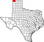
Dallam County, Texas Basics:


Dallam County Texas - Government Site

Population: 7,021
Area: 1503 square miles
County seat: Dalhart
Area code(s) in use: 806
Time zone: CST
High school graduate or higher: 71.6%
Bachelor's degree or higher: 10.7%
Median household income: $42,781
Persons in poverty: 12.6%
Home ownership rate: 62.2%
Mean travel time to work: 16.6 minutes


Adjacent counties:
Cimarron (OK)  Hartley  Moore  Sherman  Union (NM)  

Find in Texas

Map of the Dallam County area


Our detail map of Dallam County shows the Dallam County, Texas boundary lines and other interesting items.

Places in Dallam County, Texas

  Airports     show all on map

Circle H Farms Ltd Airport, Conlen Airport, Miller Airfield, Nebtex Land Co. Airport

  Buildings     show all on map

Dalhart Emergency Medical Services, Dalhart Volunteer Fire Department, Dallam - Hartley County Jail, Dallam - Hartley County Library, Texline Public Library, Texline Volunteer Fire and Rescue Department, XIT Museum

  Churches     show all on map

Antioch Baptist Church, Calvary Assembly of God Church, Central United Methodist Church, Lincoln Street Baptist Church, New Light Baptist Church, Saint Marys Church, Seventh Day Adventist Church

  Dams     show all on map

Reynolds Dam

  Forests     show all on map

Rita Blanca National Grassland

  Lakes     show all on map

Alkali Lakes, Coldwater Lakes, Flater Lake

  Locales     show all on map

Bagot Ranch, Coloney Community House, Lost Camp, Pritchard Ranch, Rita Blanca Ranger Station, Rita Blanca Work Center, Sandhill Windmill, Steel Windmill, Thompson Grove Campground, Tovrea Ranch, Wharton Ranch

  Parks     show all on map

Clarks Monument

  Populated Places     show all on map

Bolin, Buffalo Springs, Bunker Hill, Chamberlin, Coldwater, Conlen, Corlena, Dalhart, Hitt, Irwin, Kerrick, Perico, Texline, Thompson Grove, Ware, Windy Hill

  Post Offices     show all on map

Dalhart Post Office, Texline Post Office

  Reservoirs     show all on map

Reynolds Lake

  Schools     show all on map

Allyn Finch Intermediate School, Allyn Finch Intermediate School, Canyon School, Dalhart Elementary School, Dalhart High School, Dalhart Junior High School, Texline School, X I T Secondary School

  Springs     show all on map

Agua Fria Springs, Aqua Fria Spring, Black Muley Springs (historical), Buffalo Springs, Flater Springs, Government Spring, Government Springs, Horseshoe Bend Springs, Kimble Springs, Potato Spring

  Streams     show all on map

Aqua Fria Creek, Carrizo Creek, East Rita Blanca Creek, Junkyard Creek, Perico Creek, West Rita Blanca Creek

  Towers     show all on map

KXIT-AM (Dalhart), KXIT-FM (Dalhart)

  Valleys     show all on map

Compound Draw, Red Cow Draw

  Wells     show all on map

Allen Well, Badenhop Well, Big Six Well, Bull Well, Cakehouse Well, Canyon Well, Curlew Well, Dinkle Well, Dogtown Well, Dulaney Well, Eagle Well, Fiftyfive Well, Flower Well, Fortynine Well, Government Well, Inman Well, Johnson Well, Kendale Well, Lake Well, Little Duck Well, Matlock Well, New Well, Pipetower Well, Seventy Well, Seventyfive Well, Seventyone Well, Seventyseven Well, Seventytwo Well, Sis Well, Sixtynine Well, Three VS Well, Two Story Well, West Well, White Well, Woody Well, XIT Thirtysix Well,

Dallam County, Texas Population By Race (2012 estimate)

RacePopulation
WhiteDallam County White population 6,6146,613  
American IndianDallam County American Indian population 119119
MixedDallam County Mixed population 105105
AsianDallam County Asian population 4949
Hawaiian & Pacific IslanderDallam County Hawaiian & Pacific Islander population 77

Additional population tables :
State population table
Texas population by county