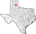
Donley County, Texas Basics:
Donley County Texas - Government Site
Population: 3,602
Area: 927 square miles
County seat: Clarendon
Area code(s) in use: 806
Time zone: CST
High school graduate or higher: 83.3%
Bachelor's degree or higher: 19.0%
Median household income: $41,875
Persons in poverty: 14.9%
Home ownership rate: 70.8%
Mean travel time to work: 17.7 minutes
Adjacent counties:
Armstrong Briscoe Carson Collingsworth Gray Hall Wheeler
Places in Donley County, Texas
Hedley Airport,
Smiley Johnson Municipal Airport/Bass Field Associated Ambulance Authority,
Clarendon Motor Company Building,
Clarendon Volunteer Fire Department, Donley County Courthouse,
Donley County Jail, G B Burton Memorial Library,
Hedley Volunteer Fire Department,
Howardwick Volunteer Fire Department,
Martin-Lowe House, Saints Roost Museum
Boydston Cemetery,
Citizens Cemetery,
Jericho Cemetery,
Odd Fellows Cemetery,
Rowe Cemetery,
Saint Marys Cemetery Martin Church Bitter Creek Ranch Lake Dam,
Greenbelt Dam,
Matthews Lake Dam,
Soil Conservation Service Site 1 Dam,
Soil Conservation Service Site 2 Dam,
Spencer Lake Dam Cattail Lake,
Lelia Lake,
Taylor Lakes Bitter Creek Ranch,
Bitter Creek Ranch,
Chamberlain Community Center,
Clarendon Country Club,
Griffin East Ranch,
Griffin North Ranch,
Griffin Ranch,
Indian Creek Ranch,
Roach Ranch,
S J Ranch Playa Lakes Wildlife Management Area - Taylor Unit,
Prospect Park Ashtola,
Clarendon,
Giles,
Hedley,
Howardwick,
Jericho,
Lelia Lake,
McKnight,
Rockledge Clarendon Post Office,
Hedley Post Office Bitter Creek Ranch Lake,
Bonita Tank,
Clarendon Lake,
Greenbelt Reservoir,
Jenny Tank,
Joe Tank,
Johnson Lake,
Matthews Lake,
Soil Conservation Service Site 1 Reservoir,
Soil Conservation Service Site 2 Reservoir,
Spencer Lake Clarendon Elementary School,
Clarendon High School,
Clarendon Junior High School,
Hedley School Bitter Creek Spring, Broome Springs, Browder Springs, Buck Spring, Chamberlain Springs, Cottonwood Springs, Dunbar Springs, Eagle Springs,
East Spring, Glenwood Springs, Highway Springs,
Indian Creek Spring,
Indian Creek Spring, Indian Springs, Kelly Springs, Luttrell Springs, Naylor Springs, Nester Springs, Parker Springs,
Parker Springs (historical), Sandy Springs, West Bitter Creek Springs,
West Spring Allen Creek,
Barton Creek,
Bell Creek,
Big Sandy Creek,
Boggy Creek,
Browder Creek,
Calf Creek,
Camp Creek,
Carrol Creek,
Cottonwood Creek,
Dalton Creek,
Dry Creek,
East Halls Creek,
East Koogle Creek,
East Lelia Lake Creek,
Edgel Creek,
Glenwood Creek,
Gyp Creek,
Hackberry Creek,
Hackberry Creek,
Halls Creek,
Hallum Creek,
Homes Creek,
Kelly Creek,
Lelia Lake Creek,
Little Skillet Creek,
McCormick Creek,
McCullum Creek,
Mitchell Creek,
Parks Creek,
Pig Plum Creek,
Polecat Creek,
Rawhide Creek,
Record Creek,
Rock Creek,
Saddlers Creek,
Sandy Creek,
Skillet Creek,
South Fork Buck Creek,
Three Tree Creek,
Troublesome Creek,
Troublesome Creek,
Turkey Creek,
West Fork Oaks Creek,
West Lelia Lake Creek,
Whitefish Creek Gunboat Mountain,
Mount Ararat Buffalo Arroyo,
Crow Hollow,
Eagle Arroyo,
Jesse Arroyo,
Kilfoil Draw,
Oklahoma Draw,
Tate Arroyo,
Troublesome Canyon,
Windy Valley,

