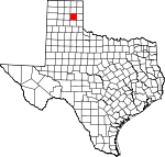
Gray County, Texas Basics:
Gray County Texas - Government Site
Population: 22,955
Area: 926 square miles
County seat: Pampa
Area code(s) in use: 806
Time zone: CST
High school graduate or higher: 81.1%
Bachelor's degree or higher: 13.9%
Median household income: $44,455
Persons in poverty: 14.9%
Home ownership rate: 75.0%
Mean travel time to work: 18.5 minutes
Adjacent counties:
Armstrong Carson Collingsworth Donley Hemphill Hutchinson Roberts Wheeler
Places in Gray County, Texas
Mc Lean/Gray County Airport,
Perry Lefors Field Airport Devils Rope Museum,
Freedom Museum USA,
Gray County Courthouse,
Gray County Jail,
Guardian Emergency Medical Service,
Historical Museum of Barbed Wire and Fencing Tools,
Hoover Volunteer Fire Department Station 1,
Hoover Volunteer Fire Department Station 2,
Lefors Volunteer Fire Department and Emergency Medical Service, Lovett Memorial Library,
McLean Emergency Medical Service,
McLean Volunteer Fire Department,
McLean-Alanreed Museum,
Pampa Fire Department Fire Marshal's Office,
Pampa Fire Department Station 1,
Pampa Fire Department Station 2,
Pampa Police Department,
Schneider Hotel,
Texas Department of Criminal Justice Region 5 Baten Intermediate Sanction Facility,
Texas Department of Criminal Justice Region 5 Rufe Jordan Unit,
White Deer Land Museum Elderidge Cemetery,
Fairview Cemetery,
Hillcrest Cemetery,
Memory Garden,
Saint Mary Cemetery Barrett Baptist Church,
Bible Baptist Church,
Church of the Nazarene,
Fellowship Baptist Church,
First Assembly of God Church,
First Free Will Baptist Church,
Grace Baptist Church,
Jehovahs Witnesses Church,
Mary Ellen and Harvester Church of Christ,
New Life Assembly of God Church,
Open Door Church of God in Christ,
Pentecostal Holiness Church,
Presbyterian Update Church,
Primera Iglesia Bautista Mexicana Church,
Progressive Baptist Church,
Saint Vincent de Paul Catholic Church,
Seventh Day Adventist Church,
United Pentecostal Church,
Westside Church of Christ,
Zion Lutheran Church City of Pampa Lake Dam,
Cubine Lake Dam,
John C Haynes Lake Dam,
McClellan Dam,
R D Back Dam McClellan Creek National Grassland Highland General Hospital,
Pampa Regional Medical Center,
Worley Hospital Bell Lake,
Deep Lake,
Lake McConnell,
Wakefield Lake Dial-Dickey Ranch,
East Bluff One Campground,
East Bluff Three Campground,
East Bluff Two Campground,
Fishermans Point Campground,
Harnes Ranch,
Hudgens Ranch,
Huselby Ranch,
Johnson Ranch,
McClellan Campground,
McClellan Picnic Area,
McDowell Campground,
McDowell Picnic Area,
Pampa Country Club,
Pampa Plant,
Pursley Ranch,
Southside Campground,
Taylor Ranch,
Webb Ranch Aspen Park,
Boys Club Park,
Central Park,
Coronado Park,
Evergreen City Park,
Highland Park,
Hobart Street Park,
Hollywood Park,
Lions Club Park,
Lions Park,
Marcus Sanders Park,
Mora Park,
Prairie Park,
Priest Park,
Recreational Park Alanreed,
Back,
Bowers City,
Boydston, Coltexo,
Denworth, Grandview,
Heaton,
Hoover,
Kingsmill,
Kingsmill Camp,
Laketon,
Lefors,
McLean,
Mesilla Park,
Pampa,
Wesco, Wilcox
Lefors Post Office,
McLean Post Office,
Pampa Post Office City of Pampa Lake,
Cubine Lake,
Franklin Lakes,
Gething Lakes,
Haynes Lake,
Lake McClellan,
R D Back Lake,
Tadpole Lake Austin Elementary School,
Austin School,
Baker School,
Carver School, Grandview - Hopkins Elementary School,
Grandview School,
Houston School,
Lamar Elementary School,
Lamar School,
Lee Junior High School, Lefors School,
Mann School,
McLean School,
Pampa High School,
Pampa Learning Center,
Pampa Middle School,
Saint Vincents School,
Travis Elementary School,
Travis School,
Wilson Elementary School,
Wilson School Big Springs, Big Springs (historical), Cabin Springs (historical), Cantonment Springs, Clear Springs, Gething Springs,
Hackberry Spring, Hackberry Springs, Indian Spring, Jewel Springs, Lefors Springs, McClellan Springs, Red Deer Springs (historical), Snowden Springs (historical), Stage Hollow Springs (historical), Stump Springs (historical),
White Horse Spring Apple Orchard Creek,
Cabin Creek,
Cantonment Creek,
Dry Sandy Creek,
Grapevine Creek,
Grapevine Creek,
Hackberry Creek,
Little Turkey Creek,
McClellan Creek,
North Fork Grapevine Creek,
North McClellan Creek,
Peterson Creek,
Plum Creek,
Pond Creek,
Red Mud Creek,
Sand Creek,
South Fork Grapevine Creek,
Thut Creek,
Turkey Creek KGRO-AM (Pampa),
KOMX-FM (Pampa),
KPDN-AM (Pampa) McClellan Creek Trail Devils Gulch,
Jack Canyon,
Saye Draw,
Stage Hollow,
Tibbetts Draw,

