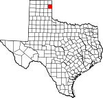
Hemphill County, Texas Basics:


Hemphill County Texas - Government Site

Population: 4,077
Area: 906 square miles
County seat: Canadian
Area code(s) in use: 806
Time zone: CST
High school graduate or higher: 78.1%
Bachelor's degree or higher: 17.6%
Median household income: $53,295
Persons in poverty: 19.2%
Home ownership rate: 75.0%
Mean travel time to work: 17.7 minutes


Adjacent counties:
Ellis (OK)  Gray  Lipscomb  Ochiltree  Roberts  Roger Mills (OK)  Wheeler  

Find in Texas

Map of the Hemphill County area


Our detail map of Hemphill County shows the Hemphill County, Texas boundary lines and other interesting items.

Places in Hemphill County, Texas

  Airports     show all on map

En Gedi Ranch Airport, Hemphill County Airport, Split B Ranch Airport, Urschel Ranch Airport

  Buildings     show all on map

Briscoe Volunteer Fire Department Station 2, Canadian Volunteer Fire Department, Gem City Fire Department, Hemphill County Emergency Medical Services, Hemphill County Jail, Hemphill County Library, Palace Theatre, River Valley Pioneer Museum

  Cemeteries     show all on map

Cataline Cemetery, Prairie Dell Cemetery, Washita Cemetery

  Churches     show all on map

Abundant Life Assembly of God Church, Believers Covenant Fellowship Church, Catholic Church, Central Baptist Church, First Baptist Church, First Presbyterian Church, Gageby Church, Methodist Church

  Dams     show all on map

Abraham Lake Dam, Arrington Lake Dam, Cleveland Lake Dam, Club Lake Dam, Dam Number 22, Kritzer Lake Dam, Lake June Dam, Lake Marvin Dam, M K Brown Reservoir Dam, Oasis Lake Dam, Soil Conservation Service Site 1 Dam, Soil Conservation Service Site 10 Dam, Soil Conservation Service Site 11 Dam, Soil Conservation Service Site 12 Dam, Soil Conservation Service Site 13dam Dam, Soil Conservation Service Site 14a Dam, Soil Conservation Service Site 14dam Dam, Soil Conservation Service Site 15 Dam, Soil Conservation Service Site 15a Dam, Soil Conservation Service Site 16 Dam, Soil Conservation Service Site 2 Dam, Soil Conservation Service Site 22 Dam, Soil Conservation Service Site 23a Dam, Soil Conservation Service Site 23b Dam, Soil Conservation Service Site 24 Dam, Soil Conservation Service Site 25 Dam, Soil Conservation Service Site 26 Dam, Soil Conservation Service Site 27 Dam, Soil Conservation Service Site 28 Dam, Soil Conservation Service Site 29 Dam, Soil Conservation Service Site 3 Dam, Soil Conservation Service Site 30 Dam, Soil Conservation Service Site 31 Dam, Soil Conservation Service Site 32 Dam, Soil Conservation Service Site 4 Dam, Soil Conservation Service Site 45 Dam, Soil Conservation Service Site 5 Dam, Soil Conservation Service Site 6 Dam, Soil Conservation Service Site 7 Dam, Soil Conservation Service Site 8 Dam, Soil Conservation Service Site 9 Dam

  Flats     show all on map

Big Flat, Tanner Flat

  Hospitals     show all on map

Hemphill County Hospital

  Lakes     show all on map

Timber Lakes

  Locales     show all on map

Anvil Park, Arrington Ranch, Canadian Feedyards, Lake Marvin Campground, McQuiddy Curves, Mendota Siding, Old Military Road Campground, Urschell Ranch, Young Ranch

  Oilfields     show all on map

Feldman Oil and Gas Field, Kelln Oil Field

  Parks     show all on map

Gene Howe Wildlife Management Area

  Populated Places     show all on map

Canadian, Clear Creek, Dreyfoos, Gageby (historical), Gem, Glazier, Hogtown (historical), Mendota, Springers Ranch (historical)

  Post Offices     show all on map

Canadian Post Office

  Reservoirs     show all on map

Abraham Lake, Arrington Lake, Big Lake, Cleveland Lake, Club Lake, Goettsche Lake, Huston-Stickley Lake, Kritzer Lake, Lake Cindy, Lake June, Lake Kiowa, Lake Marvin, Lake Sharon, M K Brown Reservoir, Oasis Lake, Soil Conservation Service Site 1 Reservoir, Soil Conservation Service Site 10 Reservoir, Soil Conservation Service Site 11 Reservoir, Soil Conservation Service Site 12 Reservoir, Soil Conservation Service Site 13 Reservoir, Soil Conservation Service Site 14 Reservoir, Soil Conservation Service Site 14a Reservoir, Soil Conservation Service Site 15 Reservoir, Soil Conservation Service Site 15a Reservoir, Soil Conservation Service Site 2 Reservoir, Soil Conservation Service Site 22 Reservoir, Soil Conservation Service Site 23a Reservoir, Soil Conservation Service Site 23b Reservoir, Soil Conservation Service Site 24 Reservoir, Soil Conservation Service Site 25 Reservoir, Soil Conservation Service Site 26 Reservoir, Soil Conservation Service Site 27 Reservoir, Soil Conservation Service Site 28 Reservoir, Soil Conservation Service Site 29 Reservoir, Soil Conservation Service Site 3 Reservoir, Soil Conservation Service Site 30 Reservoir, Soil Conservation Service Site 31 Reservoir, Soil Conservation Service Site 32 Reservoir, Soil Conservation Service Site 4 Reservoir, Soil Conservation Service Site 45 Reservoir, Soil Conservation Service Site 5 Reservoir, Soil Conservation Service Site 6 Reservoir, Soil Conservation Service Site 7 Reservoir, Soil Conservation Service Site 8 Reservoir, Soil Conservation Service Site 9 Reservoir

  Schools     show all on map

Baker Elementary School, Baker School, Blue Ridge School, Canadian Alterative School, Canadian Elementary School, Canadian High School, Canadian Middle School

  Springs     show all on map

Bent Springs, Big Timber Springs (historical), Canadian Springs (historical), Clear Springs, Hackberry Springs, Jo Spring, Jo Spring, Miles Springs (historical), Mollys Springs (historical), Needmore Springs (historical), Oasis Springs, Springer Springs, Threemile Springs

  Streams     show all on map

Big Timber Creek, Big Timber Creek, Boggy Creek, Cabin Creek, Cat Creek, Clear Creek, Dads Creek, Dry Creek, Dry Fork Boggy Creek, Dry Fork Washita River, Dry Oasis Creek, East Prong Big Timber Creek, Elk Creek, Gageby Creek, Hackberry Creek, Hay Creek, Horse Creek, Major Creek, McKay Creek, Morgan Creek, Needmore Creek, Oasis Creek, Persimmon Creek, Red Deer Creek, Simmons Creek, South Simmons Creek, Spring Creek, Threemile Creek, Turkey Creek, West Fork Clear Creek, West Fork Dry Creek, West Horse Creek, White Creek

  Summits     show all on map

Rattlesnake Hill

  Towers     show all on map

KEZP-FM (Canadian), KEZP-FM (Canadian)

  Valleys     show all on map

Mulberry Draw, Washburn Arroyo,

Hemphill County, Texas Population By Race (2012 estimate)

RacePopulation
WhiteHemphill County White population 3,9303,930  
American IndianHemphill County American Indian population 4544
AsianHemphill County Asian population 3736
MixedHemphill County Mixed population 3332
Hawaiian & Pacific IslanderHemphill County Hawaiian & Pacific Islander population 44

Additional population tables :
State population table
Texas population by county